Gwyddgrug, Pencader
- Land size
- 12 acres
- Bedrooms
- 3
- Bathrooms
- 1
Key Features
- 12 acre well equipped smallholding with option of further 6.5 acres
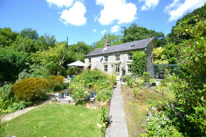
- Impressive refurbished Farmhouse
- 2 Ranges Of Stone Outbuildings
- Modern Barns suitable for livestock housing, stables or workshops
- Attractive Lands with stream frontage
- Option of Further 6.5 Acres with field shelter
- Lovely Rural Views
- Peaceful Location shared with one other property.
- 20 Minutes Carmarthen, Close to Llanybydder, Lampeter, Llandysul and Newcastle Emlyn
Description
A rurally positioned 12 acre smallholding with an attractive traditional homestead having an impressive refurbished 3 bedroomed farmhouse, 2 stone barns with potential for conversion, modern barns and useful lands with stream frontage.
Located in a private location shared with one other property, this is ideal for those seeking the rural lifestyle yet being convenient to the local towns and with a lovely aspect over the surrounding country side.
Option of a further 6.5acres of productive pasture land.
Close to Brechfa forest and only some 20 minutes North of Carmarthen
Location - Situated in a peaceful rural surroundings with attractive views, approximately half a mile from the A485 roadway in the village of Gwyddgrug, some 20 minutes North of Carmarthen but also convenient to Llanybydder, Llandysul, Newcastle Emlyn and Lampeter. The property has a lovely rural aspect, located at the end of a shared driveway with a neighbour to the rear of the homestead.
Description - A traditional farmstead in a tucked away location with one close neighbour having a fully refurbished and renovated spacious farmhouse having been completely insulated with the benefit of oil fired central heating and uPVC double glazing and offering accommodation of high residential appeal with good quality kitchen and bathroom. The property has to be internally inspected to be fully appreciated.
the property also has the benefit of double glazed windows with a feature front conservatory, enjoying the views and in our considered opinion is a turn key purchase requiring no further works, being well presented and ready for immediate occupation.
The Farmhouse provides more particularly the following -
Side Entrance Door To Porch - 2.92m x 2.59m (9'7" x 8'6") - Tiled floor, double aspect windows, door to -
Utility Room - 3.48m x 2.39m (11'5" x 7'10") - With good quality range of kitchen units at base and wall level incorporating single drainer sink unit, space for washing machine and tumble dryer, extensive work surfaces, Worcester oil fired central heating boiler, tiled walls, door to -
Cloakroom - With toilet
Main Hallway - With recently installed oak staircase to first floor, attractive tiled flooring, radiator.
On the further side is a useful Study/Office area
Kitchen/ Dining Room - 4.47m x 4.09m (14'8" x 13'5") - This room is complemented by good quality fitted kitchen units at base and wall level having a stainless steel sink unit, 4 ring ceramic hob with extractor hood over, electric oven, integrated Bosch microwave, integrated dishwasher, attractive tiled walls, feature wood effect flooring, modern contemporary styled upright radiator.
There is a further Dresser style unit matching the kitchen units. Door to conservatory.
Fireplace - There is a feature double sided wood burning stove set on a slate hearth, access from the kitchen and living room
Living Room - 7.52m x 4.09m (24'8" x 13'5") - An impressive large room with plenty of room for relaxing and entertaining with the central fireplace having the double sided multi fuel stove shared with the kitchen two radiators
Front Conservatory - 9.14m x 3.05m (30' x 10') - Of uPVC construction having two sets of patio doors opening to the sides. This enjoys a lovely aspect over the farmyard, and the land and countryside beyond.
First Floor - With access via oak staircase from the hallway to -
Galleried Landing - Walk-in airing cupboard with radiator
Bedroom 1 - 4.78m x 4.90m (15'8" x 16'1") - A large light room with double aspect windows, radiators, access to loft space
Bedroom 2 - 4.32m x 4.14m (14'2" x 13'7") - With radiator, two front windows
Bedroom 3 - 4.17m x 3.12m (13'8" x 10'3") - Radiator, access to loft, front window
Feature Bathroom - 3.66m x 2.03m (12' x 6'8") - Offering a newly fitted suite with the benefit of attractive tiled walls having panelled bath, wash hand basin, toilet, shower cubicle and heated towel rail.
Externally - The property is approached via an initial shared lane leading to a private farmyard flanked by two traditional barns, in our opinion having potential for conversion in to further accommodation if required.
Range 1 - Being the original stable block with coach house to side and workshop. This building has a rear leanto building used for loose boxes/livestock housing.
Second Former Cowshed - With leanto Dairy to front
Steel Framed Barns - 18.29m x 13.72m overall (60' x 45' overall) - Recently erected barn range, being diversely appealing with concreted floor, this would suit livestock housing, American style barn/stabling or indeed could be used for workshop/commercial purposes, offering good specification buildings with its own self contained yard area.
Land - The lands mainly provided to the front of the property running down to a feature stream, one paddock to the rear.
Optional Land - There is an optional parcel of land on the approach to the property being some 6.4 acres with a field shelter on a concrete base - GUIDE PRICE: £50,000.
Services - We are informed the property benefits from connection to mains electricity, private water from borehole, private drainage, oil fired central heating, broadband available.
Directions - From Lampeter take the A485 roadway towards Carmarthen, proceed through Llanybydder, Llanllwni and New Inn and in the village of Gwyddgrug take the left hand turning and turn immediately left again, continue along this road to its termination, just before a cattle grid, turn left on to a farm lane being the entrance of Bwlchcoed and continue to the property.
Council Tax Band - D - Amount Payable: £2048
Map Location
Property details
- Tenure
- Freehold
- Council Tax Band
- D
- Date Posted
- 2026-01-29
Market Value Analysis
Compared with 221 Farms & Smallholdings listings in Wales (10+ acres).
Energy Performance Certificate
Energy Efficiency Rating
Based on UK Energy Performance Certificate standards (EU Directive 2002/91/EC)
Running costs are one side. Planning activity, flood history and ground risks for this location are in the full report.
Utilities & Restrictions
Utilities
- Electricity
- Ask Agent
- Water
- Ask Agent
- Heating
- Ask Agent
- Broadband
- Ask Agent
- Sewerage
- Ask Agent
Rights & Restrictions
- Public Rights of Way
- Ask Agent
- Private Rights of Way
- Ask Agent
- Listed Property
- Ask Agent
- Restrictions
- Ask Agent
Listed status, conservation areas and planning constraints for this location are in the full report.
Property Features
- Accessibility
- Ask Agent
- Parking
- Parking Available
- Garden
- Garden
Beyond the particulars: planning activity, flood history, heritage and ground risks, checked for this exact spot.
Connectivity
Broadband
Fastest speed available at this postcode
7 Mbps
Under 10 Mbps here
Suitable for
- Basic browsing & email
Mobile signal
Predicted 4G and 5G signal; indoor signal depends on building materials.
Ofcom Connected Nations postcode-level predictions. Speeds and signal are modelled, not measured, and vary between addresses and providers.
Signal is the easy part. Planning activity, flood history and protected designations here are in the full report.
Nearest Schools
Primary
- Cae'R Felin1.8 miles
- Pupils
- 104
- Type
- Nursery, Infants & Juniors
- Language
- Welsh medium school / provision (including transitional)
- Llanllwni2.4 miles
- Pupils
- 37
- Type
- Infants & Juniors
- Language
- Welsh medium school / provision (including transitional)
- Llanpumsaint5.3 miles
- Pupils
- 33
- Type
- Infants & Juniors
- Language
- Welsh medium school / provision (including transitional)
- Ysgol Bro Teifi5.9 miles
- Pupils
- 861
- Type
- Middle (ages 3-19)
- Language
- Welsh medium school / provision (including transitional)
- Brynsaron6 miles
- Pupils
- 51
- Type
- Infants & Juniors
- Language
- Welsh medium school / provision (including transitional)
Secondary
- Ysgol Bro Teifi5.9 miles
- Pupils
- 861
- Type
- Middle (ages 3-19)
- Language
- Welsh medium school / provision (including transitional)
- Ysgol Bro Pedr9.9 miles
- Pupils
- 967
- Type
- Middle (ages 3-19)
- Language
- Dual language school / provision (Welsh and English) (including transitional)
- Ysgol Gyfun Emlyn11 miles
- Pupils
- 502
- Type
- Secondary (ages 11-19)
- Language
- Dual language school / provision (Welsh and English) (including transitional)
- Queen Elizabeth High School11 miles
- Pupils
- 1,289
- Type
- Secondary (ages 11-19)
- Language
- English medium school / provision
- Ysgol Gyfun Gymraeg Bro Myrddin12 miles
- Pupils
- 929
- Type
- Secondary (ages 11-19)
- Language
- Welsh medium school / provision (including transitional)
Distances are straight-line from the advertised location. Source: the national school registers (DfE, Welsh Government, Scottish Government) and Ofsted.
Schools are just the start: sold prices nearby, planning activity and any flood history are in the full report.
Amenities
Supermarket
GP surgery
Pharmacy
Straight-line distances from the advertised location. Sources: NHS records, Geolytix supermarket locations, OS Open Greenspace and the national trails registers.
The area stacks up? Now check the location itself: planning nearby, protected designations and past flooding.
Getting Around
Nearest station
Nearest bus stop
Typical drive times
Straight-line distances from the advertised location; drive times are typical free-flow times over OpenStreetMap road data, so allow more at peak. Public transport locations from DfT NaPTAN.
Easy to reach matters. So do planning activity, flood history and ground risks: all in the full report.
Flood Risk
Natural Resources Wales open data, checked around the advertised map pin for the listed acreage. Long-term risk counts flood defences; the planning map's flood zones do not. Provided by LandSale, not the listing agent, and not part of the agent's particulars. Risk varies across a holding, so verify before committing.
Rivers and the sea
Planning map: Flood Zone 1.
Surface water
Not at the pin: mapped about 20 metres away.
These bandings are the summary. Where this location sits on the flood maps, plus planning activity, heritage and ground risks, is in the full report.
Important notice: Information, maps and tags on this page are drawn from the advertising agent's marketing materials or generated automatically. LandSale has not verified them. Relying on these details is at your own risk, always carry out independent checks before committing to a purchase.
LandSale full disclaimer
Marketing information only - not formal particulars. The details on this website are provided for general guidance and do not constitute an offer or contract. Neither LandSale nor the advertising estate/land agent accepts responsibility for any inaccuracy.
1. Source of information
- Listing content: Core description, asking price, tenure, measurements, photographs and planning history originate from the marketing materials of the advertising estate or land agent. LandSale does not author this content and cannot guarantee its accuracy.
- Automated tags & categorisation: Property type, land-use class, acreage bands and similar labels may be applied by machine-learning models. They are intended as a helpful guide only and may not reflect the property's legal status or permitted use.
- Third-party & enriched data layers: Maps, boundary outlines, planning designations, soil reports, broadband coverage and other environmental or location-based insights are licensed from external suppliers. Such data are supplied “as is", may be incomplete or out of date and are subject to change without notice.
2. Verification required
Prospective purchasers must verify critical matters, including but not limited to planning permission, title boundaries, public rights of way, environmental constraints, acreage, services, access and VAT status, through their own inspections, specialist surveys, legal advisers and the selling agent before relying on the information or entering into any contract.
3. No warranty or liability
LandSale gives no warranty, express or implied, as to the accuracy, completeness or fitness for any particular purpose of the information displayed. LandSale shall not be liable for any loss, damage, cost or expense arising directly or indirectly from any use of or reliance on such information, save where liability may not be excluded by law.
4. Updates & feedback
If you believe any detail on this listing is inaccurate, please let us know. We will investigate and, where appropriate, update the listing or notify the agent.
© LandSale | Version 1.3 - August 2026
Similar properties for sale
- Price
- Offers in Excess of£550,000
- Size
- 14 acres
Gwernogle CARMARTHENSHIRE, Llanfihangel Rhos-y-Corn, Carmarthenshire SA32 Wales
Added on 08/10/2026Smallholding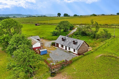
- Price
- £595,000
- Size
- 46 acres
Gwernogle, Carmarthen, Carmarthenshire., Llanfihangel Rhos-y-Corn, Carmarthenshire SA32 Wales
Added on 29/01/2026Livestock Farm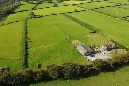
- Price
- £745,000
- Size
- 9.5 acres
Capel Dewi, Llandysul, SA44, Llandysul, Ceredigion SA44 Wales
Added on 13/08/2026Smallholding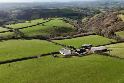
- Price
- Offers in Region of£769,000
- Size
- 30 acres
Whitemill, Carmarthen. SA32, Abergwili, Carmarthenshire SA32 Wales
Added on 29/01/2026Smallholding
- Price
- £650,000
- Size
- 10.2 acres
Ty Mawr, Carmarthenshire, Llanybydder, Carmarthenshire SA40 Wales
Added on 27/06/2026Smallholding
- Price
- £800,000
- Size
- 13 acres
Abergorlech Road, Nantgaredig, SA32, Carmarthen, Carmarthenshire SA32 Wales
Added on 24/09/2026Smallholding
- Price
- £800,000
- Size
- 13 acres
Nantgaredig, Carmarthen, SA32, Carmarthen, Carmarthenshire SA32 Wales
Added on 18/07/2026Smallholding
- Price
- £595,000
- Size
- 18.5 acres
with 3 bedroom barn conversion, Cwmduad, Carmarthen, SA33, Carmarthen, Carmarthenshire SA33 Wales
Added on 09/10/2026Smallholding
- Price
- £500,000
- Size
- 6.5 acres
Saron, Llandysul, SA44, Llangeler, Carmarthenshire SA44 Wales
Added on 16/09/2026Smallholding
- Price
- Offers in Region of£599,950
- Size
- 10 acres
Added on 29/01/2026Smallholding