Dolfach Isaf, Llangurig, Llanidloes, Powys, SY18
- Land size
- 15.36 acres
- Bedrooms
- 4
Key Features
- Charming 4 bedroomed stone built detached farmhouse
- Outbuildings
- 15.36 acres of land
Description
Dolfach Isaf is a highly desirable smallholding ideally situated within easy reach of the popular market towns of Llanidloes and Rhayader. The property offers over 2,000 sqft of versatile family accommodation, blending charm and practicality in a peaceful rural setting.
Complementing the main residence is an appealing range of well-preserved traditional stone barns, a charming stone-built summer house, and approximately 15.36 acres of high-quality pastureland. In addition, the property benefits from approximately 1,300 metres of single bank fishing rights along the renowned River Wye.
Together, these features create a highly versatile offering, well-suited to a variety of purchasers — whether seeking an equestrian, agricultural, or lifestyle opportunity in an idyllic rural setting.
FARMHOUSE
A charming stone-built four-bedroom farmhouse, offering approximately 2,058 sqft of well-proportioned living accommodation. The ground floor comprises a study, cloakroom with WC, reception/living room, pantry, dining room, and a spacious kitchen, all thoughtfully arranged to suit family living. Stairs rise to the first floor where there are four bedrooms, including a principal bedroom with en-suite, as well as a separate family bathroom. The first floor also offers access to the attic.
OUTSIDE
Externally, the property is complemented by a range of well-maintained traditional stone barns with slate roofs, offering approximately 2,289 sqft of additional space. The garage offers additional potential, benefiting from an existing first floor. These buildings are suitable for a variety of uses and offer potential for conversion, subject to the necessary planning consents. A delightful stone-built summer house further enhances the offering, with the adjoining copse features a charming bluebell woodland, home to two magnificent beech trees estimated to be over 400 years old.
LAND
The holding extends to approximately 15.36 acres (6.22 hectares) of Grade 4 grass pasture, conveniently divided into several paddocks ideal for the grazing of livestock or horses.
SERVICES
The property benefits from mains water, mains electricity, oil-fired central heating, and private septic tank drainage.
N.B. The services, appliances and flues have not been tested, and no warranty is provided with regard to their condition.
COUNCIL TAX
Band E - Local Authority: Powys (Montgomeryshire 1)
BOUNDARY RESPONSIBILITIES
Any purchaser shall be deemed to have full knowledge of all boundaries and neither the Vendor nor the Vendors Agents are responsible for defining the boundaries or ownership thereof.
BASIC PAYMENT SCHEME
The land is registered with Rural Payments Wales. No entitlements are included within the sale.
TENURE
Freehold with vacant possession on completion. The property is currently held under title numbers WA602031.
SPORTING & MINERAL RIGHTS
It is understood that the sporting rights are included with the property, which also enjoys the benefit of approximately 1,300 metres of single bank fishing rights along the renowned River Wye. Mineral rights are excluded from the sale.
EASEMENTS, WAYLEAVES AND RIGHTS OF WAY
The property is sold subject to and with the benefit of all existing wayleaves, easements, and rights of way, public and private whether specifically mentioned or not.
A right of way is retained by an adjoining landowner, as shown by the brown dashed line on the attached plan. This right permits access on foot or vehicular with agricultural machinery.
METHOD OF SALE
The land is being offered for sale by Private Treaty with offers to be submitted to Tom Davies BSc (Hons) MRICS FAAV at our Rural Office.
VIEWING
Accompanied by prior arrangement with the selling agents.
DIRECTIONS
What3words: ///limitless.clarifies.excavated
Postcode: SY18 6RX
MONEY LAUNDERING REGULATIONS
On putting forward an offer to purchase you will be required to produce adequate identification to prove your identity within the terms of the Money Laundering Regulations (MLR 2017 came into force 26th June 2017). Appropriate examples: Passport or Photographic Driving Licence and a recent
Utility Bill.
MORTGAGE SERVICES
Should you decide to use the services of the Mortgage Advice Bureau, you should know that we would expect to receive a referral fee of £250.00 from them for recommending you to them.
FLOOD RISK (PER NRW)
BROADBAND AND MOBILE SIGNAL
Map Location
Property details
- Tenure
- Ask Agent
- Council Tax Band
- TBC
- Date Posted
- 2026-01-29
Market Value Analysis
Compared with 168 Homes with Land listings in Wales (10+ acres).
Utilities & Restrictions
Utilities
- Electricity
- Ask Agent
- Water
- Ask Agent
- Heating
- Ask Agent
- Broadband
- Ask Agent
- Sewerage
- Ask Agent
Rights & Restrictions
- Public Rights of Way
- Ask Agent
- Private Rights of Way
- Ask Agent
- Listed Property
- Ask Agent
- Restrictions
- Ask Agent
Listed status, conservation areas and planning constraints for this location are in the full report.
Property Features
- Accessibility
- Ask Agent
- Parking
- Parking Available
- Garden
- Garden
Beyond the particulars: planning activity, flood history, heritage and ground risks, checked for this exact spot.
Connectivity
Broadband
Fastest speed available at this postcode
17 Mbps
Standard (10-30 Mbps)
Suitable for
- Web & social
- Music streaming
- Standard video calls
Mobile signal
Predicted 4G and 5G signal; indoor signal depends on building materials.
Ofcom Connected Nations postcode-level predictions. Speeds and signal are modelled, not measured, and vary between addresses and providers.
Signal is the easy part. Planning activity, flood history and protected designations here are in the full report.
Nearest Schools
Primary
- Llanidloes C.P. School4.9 miles
- Pupils
- 267
- Type
- Nursery, Infants & Juniors
- Language
- English medium school / provision
- Rhayader C.I.W. School6.3 miles
- Pupils
- 221
- Type
- Nursery, Infants & Juniors
- Language
- Dual language school / provision (Welsh and English) (including transitional)
- Ysgol Dyffryn Trannon9.3 miles
- Pupils
- 98
- Type
- Nursery, Infants & Juniors
- Language
- Welsh medium school / provision (including transitional)
- Llandinam C.P. School10 miles
- Pupils
- 33
- Type
- Nursery, Infants & Juniors
- Language
- English medium school / provision
- Ysgol Gymunedol Syr John Rhys10 miles
- Pupils
- 15
- Type
- Infants & Juniors
- Language
- Welsh medium school / provision (including transitional)
Secondary
- Llanidloes High School4.8 miles
- Pupils
- 703
- Type
- Secondary (ages 11-19)
- Language
- Dual language school / provision (Welsh and English) (including transitional)
- Newtown High School15 miles
- Pupils
- 896
- Type
- Secondary (ages 11-19)
- Language
- English medium school / provision
- Ysgol Bro Hyddgen18 miles
- Pupils
- 441
- Type
- Middle (ages 4-19)
- Language
- Welsh medium school / provision (including transitional)
- Ysgol Calon Cymru18 miles
- Pupils
- 948
- Type
- Secondary (ages 11-19)
- Language
- Dual language school / provision (Welsh and English) (including transitional)
- Ysgol Henry Richard18 miles
- Pupils
- 387
- Type
- Middle (ages 3-16)
- Language
- Welsh medium school / provision (including transitional)
Distances are straight-line from the advertised location. Source: the national school registers (DfE, Welsh Government, Scottish Government) and Ofsted.
Schools are just the start: sold prices nearby, planning activity and any flood history are in the full report.
Amenities
Supermarket
GP surgery
Pharmacy
Straight-line distances from the advertised location. Sources: NHS records, Geolytix supermarket locations, OS Open Greenspace and the national trails registers.
The area stacks up? Now check the location itself: planning nearby, protected designations and past flooding.
Getting Around
Nearest station
Nearest bus stop
Typical drive times
Straight-line distances from the advertised location; drive times are typical free-flow times over OpenStreetMap road data, so allow more at peak. Public transport locations from DfT NaPTAN.
Easy to reach matters. So do planning activity, flood history and ground risks: all in the full report.
Flood Risk
Natural Resources Wales open data, checked around the advertised map pin for the listed acreage. Long-term risk counts flood defences; the planning map's flood zones do not. Provided by LandSale, not the listing agent, and not part of the agent's particulars. Risk varies across a holding, so verify before committing.
Rivers and the sea
Not at the pin: mapped about 60 metres away.
Planning map: Flood Zone 3, about 50 metres away.
Surface water
Not at the pin: mapped about 40 metres away.
These bandings are the summary. Where this location sits on the flood maps, plus planning activity, heritage and ground risks, is in the full report.
Important notice: Information, maps and tags on this page are drawn from the advertising agent's marketing materials or generated automatically. LandSale has not verified them. Relying on these details is at your own risk, always carry out independent checks before committing to a purchase.
LandSale full disclaimer
Marketing information only - not formal particulars. The details on this website are provided for general guidance and do not constitute an offer or contract. Neither LandSale nor the advertising estate/land agent accepts responsibility for any inaccuracy.
1. Source of information
- Listing content: Core description, asking price, tenure, measurements, photographs and planning history originate from the marketing materials of the advertising estate or land agent. LandSale does not author this content and cannot guarantee its accuracy.
- Automated tags & categorisation: Property type, land-use class, acreage bands and similar labels may be applied by machine-learning models. They are intended as a helpful guide only and may not reflect the property's legal status or permitted use.
- Third-party & enriched data layers: Maps, boundary outlines, planning designations, soil reports, broadband coverage and other environmental or location-based insights are licensed from external suppliers. Such data are supplied “as is", may be incomplete or out of date and are subject to change without notice.
2. Verification required
Prospective purchasers must verify critical matters, including but not limited to planning permission, title boundaries, public rights of way, environmental constraints, acreage, services, access and VAT status, through their own inspections, specialist surveys, legal advisers and the selling agent before relying on the information or entering into any contract.
3. No warranty or liability
LandSale gives no warranty, express or implied, as to the accuracy, completeness or fitness for any particular purpose of the information displayed. LandSale shall not be liable for any loss, damage, cost or expense arising directly or indirectly from any use of or reliance on such information, save where liability may not be excluded by law.
4. Updates & feedback
If you believe any detail on this listing is inaccurate, please let us know. We will investigate and, where appropriate, update the listing or notify the agent.
© LandSale | Version 1.3 - August 2026
Listing agent
Morris Marshall & Poole, Welshpool
28 Broad Street, Welshpool, SY21 7RW
Similar properties for sale
- Price
- Guide Price£785,000
- Size
- 23.99 acres
Tylwch, Llanidloes, Powys, SY18, Llanidloes Without, Powys SY18 Wales
Added on 29/01/2026Equestrian property
- Price
- Guide Price£650,000
- Size
- 13.57 acres
Van, Llanidloes, Powys, SY18, Llanidloes Without, Powys SY18 Wales
Added on 29/01/2026Cottage
- Price
- Guide Price£850,000
- Size
- 8.43 acres
Van, Llanidloes, Powys, SY18, Llanidloes Without, Powys SY18 Wales
Added on 28/08/2026Country Home
- Price
- £825,000
- Size
- 8 acres
Lledrod, Aberystwyth, SY23, Aberystwyth, Ceredigion SY23 Wales
Added on 07/10/2026Holiday Let Property
- Price
- £700,000
- Size
- 59.44 acres
Aberhafesp, Newtown, Powys, SY16, Betws Cedewain, Powys SY16 Wales
Added on 01/10/2026Farm
- Price
- £640,000
- Size
- 18 acres
Added on 05/06/2026Smallholding
- Price
- Guide Price£795,000
- Size
- 12.3 acres
Gold Y Gors & Pencerrig Lake, Builth Wells, Powys, Mid Wales, LD2, Llanelwedd, Powys LD2 Wales
Added on 29/01/2026Lakefront property
- Price
- Guide Price£995,000
- Size
- 10 acres
Added on 29/01/2026Multiple Dwelling Property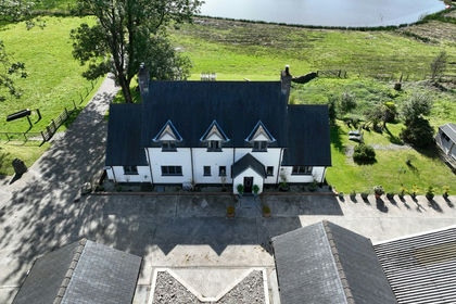
- Price
- Guide Price£950,000
- Size
- 30 acres
Added on 06/07/2026Residential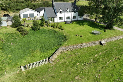
- Price
- £950,000
- Size
- 30 acres
Added on 09/09/2026Smallholding