Llanedi, Pontarddulais, SA4
- Land size
- 42.26 acres
- Bedrooms
- 3
- Bathrooms
- 1
Key Features
- 42.26 acre residential holding of great appeal
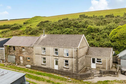
- Three bedroomed character farmhouse
- Ample ranges of useful outbuildings
- Pasture and woodland
- In an elevated rural position
- Popular semi-rural location on the periphery of Llanedi village
- Easy links to M4 / A48 corridor
Description
The farm consists of a 3-bedroomed centrally heated character farmhouse with generous sized lawned gardens surrounding, with various types of outbuildings which may have potential for a variety of uses subject to any planning consents that may be required., together with useful gently sloping pastureland and an area of mixed woodland to the eastern boundary and in all amounting to about 42.26 acres.
Description
In our opinion an attractive residential holding located in a rural position overlooking the valley below yet within easy reach of the M4 motorway either at Hendy or Pont Abraham.
The farm consists of the three bedroomed centrally heated character farmhouse with generous sized lawned gardens surrounding. There are ranges of various types of outbuildings which may have potential for a variety of uses subject to any planning consents that may be required. Together with useful gently sloping pastureland and an area of mixed woodland to the eastern boundary and in all amounting to about 42.26 acres.
Situation
Approached over a private driveway off Heol Troeon which leads directly down to Tycanol. About 2.5 miles from Pontardulais Town which has a good shopping centre and the benefit of the primary and comprehensive schools. Swansea City is approximately 14 miles distant.
Directions
From Junction 49 at Pont Abraham take the Ammanford road (A483) proceed up the hill and take first turning on the right signposted to Llanedi. Arriving at Llanedi take first left onto Heol Troeon, continue for about 0.20 of a mile and then take second right hand turn onto Tycanol driveway which is signposted.
The Farmhouse
Solid fuel central heating system (not tested)
Double glazed windows throughout
Front Entrance Door
Leading directly into: -
Lounge
Approx. 10' 5" x 14' 10" (3.17m x 4.52m) Beamed ceiling. Radiator. Light airy room with two windows. Door to inner hall. Alcove into: -
Dining Room
Approx. 9' 8" x 13' 0" (2.95m x 3.96m) Beamed ceiling. Fitted cupboard. Window overlooking front garden. Door to: -
Sitting Room
Approx. 15' 10" x 13' 0" (4.83m x 3.96m) Beamed ceiling. Stairs to first floor. Rayburn solid fuel stove. Window overlooking front garden. Storage space under stairs. Double doors to: -
Kitchen/Breakfast Room
Approx. 8' 0" x 28' 8" (2.44m x 8.74m) Galley style kitchen. Fitted base and wall units. Single drainer sink unit. Plumbed for washing machine. Inset kitchen cupboard. Radiator. Overlooking rear lawn. Door to: -
Inner Hall
Bathroom
White suite consisting of a panelled bath, pedestal wash basin and w.c. Heated towel rail. Tiled surround
Landing
Radiator. Built in cupboard
Bedroom No. 1
Approx. 10' 6" x 11' 1" (3.20m x 3.38m) Side aspect. Radiator. Overlooking the garden
Seperate w.c.
Pedestal wash basin and w.c. Fitted wall mounted mirror. Pull switch
Bedroom No. 2
Approx. 6' 11" x 9' 11" (2.11m x 3.02m) Front room. Radiator
Bedroom No. 3
Approx. 12' 10" x 13' 0" (3.91m x 3.96m) Built in airing cupboard. Access to attic space
Outside
Generous sized gardens to front, side and rear comprising mostly well kept lawned areas and shrub borders.
Storage Building
Overall measurement approx. 17' 0" x 35' 0" (5.18m x 10.67m) Stone built under a C.I. roof
1. Old stable, part loft over
2. Garden storage room
Footpath leading to farm buildings
Lower Yard
Garage/Workshop
24' 6" x 38' 0" (7.47m x 11.58m) Block construction under a box profile sheeted roof.
Adjoining Storage
Approx. 15' 0" x 30' 0" (4.57m x 9.14m) Block/stone construction under a box profile sheeted roof.
Range
Approx. 30' 0" x 53' 0" (9.14m x 16.15m) max.
1. Open fronted young cattleshed
2. Workshop
3. Old Dairy
Part block, part stone with part C.I. roof and part tiled
Outside w.c. to rear of building
Range
Approx. 18' 0" x 80' 0" (5.49m x 24.38m) Part stone/block, part C.I. box profile and part asbestos sheeted roofs
1. Old milking parlour
2. Collecting pen
3. Loose box with loft over
4. Two No. calf pens
Office - Adjoining the above range
Approx. 15' 0" x 17' 0" (4.57m x 5.18m) Block built under a box profile sheeted roof
Top Yard
Old Silo
Approx. 36' 0" x 60' 0" (10.97m x 18.29m) Part block walling, part box profile, part C.I roof and side cladding
Cubicle Shed
Approx. 61' 0" x 42' 0" (18.59m x 12.80m) Block walling, part asbestos and part C.I. roof
With adjoining: -
Workshop
Approx. 16' " x 20' 0" (NaNm x 6.10m)
The Land
The total area of the farm is about 42.26 acres out of which approximately 28.50 acres is predominantly south facing gently sloping pasture, to the eastern boundary is an area of mixed woodland being about 12.60 acres and the remaining 1.16 acres represents the area of the farmhouse, gardens, yards and outbuildings
Tenure
Freehold with vacant possession. Land Registry Title Nos. CYM858956 and WA537245
Services
Mains water and electricity to the farmhouse and many of the farm outbuildings. Private drainage to the farmhouse.
Energy Performance Certificate
Grade F
Wayleaves, Easements and Rights of Way
The property is sold subject to and with the benefits of all rights, including rights of way, whether public or private, light, support, drainage, water, and electricity supplies and any other rights and obligations, easements and proposed wayleaves for masts, pylons, stays, cables, drains and water, gas and other pipes, whether referenced or not.
1. Existing footpath running along the northern boundary exiting out of the woodland to adjoining property.
2. The farm has the benefit of an existing legal vehicular and pedestrian right of way over that part of the access drive which is not owned and shown coloured brown on attached plan.
3. Wayleave for National Grid.
Planning
All other planning related enquires, please contact Carmarthenshire County Council Planning Department.
Planning Services, Civic Offices, Crescent Road, Llandeilo, Carmarthenshire, SA19 6HW.
Tel: 01267 234567
I.A.C.S.
It is understood that the land is registered.
Basic Payment Scheme
The farm has the benefit of entitlements under the scheme which are not included in the sale. The entitlements can be purchased at valuation. (if required)
Local Authority
Carmarthenshire County Council, County Hall, Castle Hill, Carmarthen, SA31 1JP.
Tel: 01267 234567
Council Tax
Carmarthenshire County Council - Band D - Approx. £2232.06 2025/2026
Viewing
Strictly by appointment with sole selling agents Rees Richards & Partners.
Please contact Swansea office for further information - Druslyn House, De la Beche Street, Swansea SA1 3HH
Tel: 01792 650705
Email: [email protected]
Map Location
Property details
- Tenure
- Freehold
- Council Tax Band
- D
- Date Posted
- 2026-01-29
Market Value Analysis
Compared with 130 Farms & Smallholdings listings in Wales (25+ acres).
Energy Performance Certificate
Energy Efficiency Rating
Based on UK Energy Performance Certificate standards (EU Directive 2002/91/EC)
Running costs are one side. Planning activity, flood history and ground risks for this location are in the full report.
Property Brochure
Seen the details? The full report adds the independent checks: planning activity, flood history, heritage and ground.
Utilities & Restrictions
Utilities
- Electricity
- Mains Supply
- Water
- Mains Supply
- Heating
- Central
- Broadband
- Ask Agent
- Sewerage
- Private Supply
Rights & Restrictions
- Public Rights of Way
- Ask Agent
- Private Rights of Way
- Yes
- Listed Property
- Ask Agent
- Restrictions
- Ask Agent
Listed status, conservation areas and planning constraints for this location are in the full report.
Property Features
- Accessibility
- Ask Agent
- Parking
- 2 parking spaces, 1 garage
- Garden
- 3 gardens
Beyond the particulars: planning activity, flood history, heritage and ground risks, checked for this exact spot.
Connectivity
Broadband
Fastest speed available at this postcode
1.8 Gbps
Gigabit full fibre
Suitable for
- 4K streaming on every screen
- Full-time home working
- Online gaming & big downloads
Fixed wireless access may also be an option here.
Mobile signal
Predicted 4G and 5G signal; indoor signal depends on building materials.
Ofcom Connected Nations postcode-level predictions. Speeds and signal are modelled, not measured, and vary between addresses and providers.
Signal is the easy part. Planning activity, flood history and protected designations here are in the full report.
Nearest Schools
Primary
- Llanedi969 metres
- Pupils
- 21
- Type
- Infants & Juniors
- Language
- Dual language school / provision (Welsh and English) (including transitional)
- Hendy2.2 miles
- Pupils
- 187
- Type
- Nursery, Infants & Juniors
- Language
- Dual language school / provision (Welsh and English) (including transitional)
- Y.G.G. Bryniago2.2 miles
- Pupils
- 198
- Type
- Nursery, Infants & Juniors
- Language
- Welsh medium school / provision (including transitional)
- Pontarddulais Primary School2.3 miles
- Pupils
- 391
- Type
- Nursery, Infants & Juniors
- Language
- English medium school / provision
- Ty-Croes2.3 miles
- Pupils
- 199
- Type
- Nursery, Infants & Juniors
- Language
- English medium school / provision
Secondary
- Pontarddulais Comprehensive School1.9 miles
- Pupils
- 848
- Type
- Secondary (ages 11-16)
- Language
- English medium school / provision
- Ysgol Dyffryn Aman4.2 miles
- Pupils
- 1,547
- Type
- Secondary (ages 11-19)
- Language
- Dual language school / provision (Welsh and English) (including transitional)
- Ysgol Maes Y Gwendraeth4.6 miles
- Pupils
- 1,084
- Type
- Secondary (ages 11-19)
- Language
- Welsh medium school / provision (including transitional)
- Penyrheol Comprehensive School4.8 miles
- Pupils
- 860
- Type
- Secondary (ages 11-16)
- Language
- English medium school / provision
- Bryngwyn School5.5 miles
- Pupils
- 1,045
- Type
- Secondary (ages 11-16)
- Language
- Dual language school / provision (Welsh and English) (including transitional)
Distances are straight-line from the advertised location. Source: the national school registers (DfE, Welsh Government, Scottish Government) and Ofsted.
Schools are just the start: sold prices nearby, planning activity and any flood history are in the full report.
Amenities
Supermarket
GP surgery
Pharmacy
Green space
Straight-line distances from the advertised location. Sources: NHS records, Geolytix supermarket locations, OS Open Greenspace and the national trails registers.
The area stacks up? Now check the location itself: planning nearby, protected designations and past flooding.
Getting Around
Nearest station
Nearest bus stop
Typical drive times
Straight-line distances from the advertised location; drive times are typical free-flow times over OpenStreetMap road data, so allow more at peak. Public transport locations from DfT NaPTAN.
Easy to reach matters. So do planning activity, flood history and ground risks: all in the full report.
Flood Risk
Natural Resources Wales open data, checked around the advertised map pin for the listed acreage. Long-term risk counts flood defences; the planning map's flood zones do not. Provided by LandSale, not the listing agent, and not part of the agent's particulars. Risk varies across a holding, so verify before committing.
Rivers and the sea
Planning map: Flood Zone 1.
Surface water
Not at the pin: mapped about 120 metres away.
These bandings are the summary. Where this location sits on the flood maps, plus planning activity, heritage and ground risks, is in the full report.
Important notice: Information, maps and tags on this page are drawn from the advertising agent's marketing materials or generated automatically. LandSale has not verified them. Relying on these details is at your own risk, always carry out independent checks before committing to a purchase.
LandSale full disclaimer
Marketing information only - not formal particulars. The details on this website are provided for general guidance and do not constitute an offer or contract. Neither LandSale nor the advertising estate/land agent accepts responsibility for any inaccuracy.
1. Source of information
- Listing content: Core description, asking price, tenure, measurements, photographs and planning history originate from the marketing materials of the advertising estate or land agent. LandSale does not author this content and cannot guarantee its accuracy.
- Automated tags & categorisation: Property type, land-use class, acreage bands and similar labels may be applied by machine-learning models. They are intended as a helpful guide only and may not reflect the property's legal status or permitted use.
- Third-party & enriched data layers: Maps, boundary outlines, planning designations, soil reports, broadband coverage and other environmental or location-based insights are licensed from external suppliers. Such data are supplied “as is", may be incomplete or out of date and are subject to change without notice.
2. Verification required
Prospective purchasers must verify critical matters, including but not limited to planning permission, title boundaries, public rights of way, environmental constraints, acreage, services, access and VAT status, through their own inspections, specialist surveys, legal advisers and the selling agent before relying on the information or entering into any contract.
3. No warranty or liability
LandSale gives no warranty, express or implied, as to the accuracy, completeness or fitness for any particular purpose of the information displayed. LandSale shall not be liable for any loss, damage, cost or expense arising directly or indirectly from any use of or reliance on such information, save where liability may not be excluded by law.
4. Updates & feedback
If you believe any detail on this listing is inaccurate, please let us know. We will investigate and, where appropriate, update the listing or notify the agent.
© LandSale | Version 1.3 - August 2026

Listing agent
Rees Richards and Partners, Swansea
12 Spilman Street, Carmarthen, SA31 1LQ
Contact Rees Richards and Partners, Swansea
12 Spilman Street, Carmarthen, SA31 1LQ
View agent profileSimilar properties for sale
- Price
- Guide Price£725,000
- Size
- 66 acres
Lletty Farm, Llannon, Llanelli, Carmarthenshire, Llannon, Carmarthenshire SA14 Wales
Added on 22/06/2026Smallholding
- Price
- Offers in Region of£725,000
- Size
- 65 acres
Lletty Farm, Llannon, Llanelli, Carmarthenshire, Llannon, Carmarthenshire SA14 Wales
Added on 22/06/2026Farmland
- Price
- £800,000
- Size
- 84 acres
Whitemill, Carmarthen, SA32, Abergwili, Carmarthenshire SA32 Wales
Added on 30/07/2026Farm
- Price
- Offers in Region of£769,000
- Size
- 30 acres
Whitemill, Carmarthen. SA32, Abergwili, Carmarthenshire SA32 Wales
Added on 29/01/2026Smallholding
- Price
- £550,000
- Size
- 45 acres
Talley, Llandeilo, Carmarthenshire., Talley, Carmarthenshire SA19 Wales
Added on 24/08/2026Smallholding
- Price
- £745,000
- Size
- 62 acres
Crugybar, Llanwrda, Carmarthenshire., Cynwyl Gaeo, Carmarthenshire SA19 Wales
Added on 29/01/2026Smallholding
- Price
- Offers in Region of£650,000
- Size
- 23.5 acres
St Clears, Carmarthen, SA33, St. Clears, Carmarthenshire SA33 Wales
Added on 21/03/2026Smallholding
- Price
- £595,000
- Size
- 46 acres
Gwernogle, Carmarthen, Carmarthenshire., Llanfihangel Rhos-y-Corn, Carmarthenshire SA32 Wales
Added on 29/01/2026Livestock Farm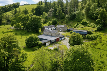
- Price
- Guide Price£850,000
- Size
- 140 acres
Added on 11/06/2026Farmland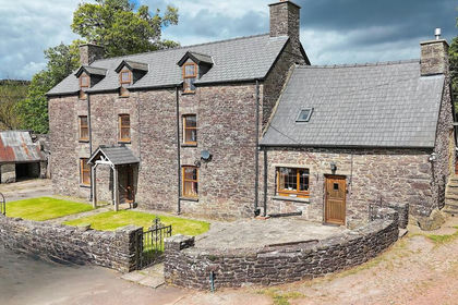
- Price
- £875,000
- Size
- 28.8 acres
Added on 20/05/2026Smallholding