Broadclyst, Exeter, Devon
- Bedrooms
- 4
- Bathrooms
- 3
Key Features
- Situated on an Exclusive Development of just 13 Barn Conversions
- Thoughtfully Restored Inkeeping with the Heritage
- Modern Fixtures and Fittings to Complement the Character
- Renewable, Eco Friendly Air Source Heating
- Surrounded by Rolling Devon Countryside
- Large Private Garden backing onto Farmland
- Ample Parking and Private Driveway
- Within Clyst Vale Community School Catchment Area
Description
Description
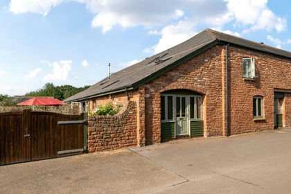
Nestled in a surprisingly peaceful location, Bellworthy House is a superbly converted farmhouse offers four double bedrooms, perfect for a growing family.
The high-quality finish is evident throughout, with three reception rooms providing ample space for entertaining or relaxation. Situated on a generous plot, this charming property boasts a traditional layout with separate living room, dining room a an additional space to use as a home office or play room. A useful utility area with WC can be found off the welcoming hallway. Bellworthy House is flooded with natural light with near 360 degree views of rolling countryside, creating a warm and inviting atmosphere.
The sleek kitchen/ breakfast room features high-end NEFF and BOSCH appliances and stylish Quartz countertops, ideal for culinary enthusiasts.
Upstairs 4 double bedrooms, two with luxury en suite shower rooms with stylish tiling and rainfall show heads.
Outside, a driveway with ample parking provides convenience for multiple vehicles. With picturesque surroundings and a convenient location, this property offers the perfect blend of rural tranquillity and modern living.
About Kerswell Barton:
Dating back to 1875, Kerswell Barton, Broadclyst is a fine example of a Victorian Model Farm and one of the largest still in existence in Devon. Kerswell Barton functioned as a working farm for livestock and produce until 2010 when it was sold to the current owners.
A Victorian Model Farm was an 18th-19th century experimental farm, which researched and demonstrated improvements in agricultural techniques, efficiency, and building layout. Education and commitment to improving welfare standards of workers were also aspects of the ideal farm movement. Farm buildings were designed to be beautiful as well as utilitarian-inspired by the ideals of the enlightenment.
English Heritage have deemed Kerswell Barton a building of Historic Significance that should now be preserved through residential use.
Broadclyst itself is situated in the heart of the National Trust Killerton Estate which was gifted in 1944 by Sir Richard Acland to the National Trust incorporating over 6400 acres including working farms and 240 cottages. Killerton House, within the estate have year round activities for all the family. However records from 1909 show that Kerswell Barton has always been a totally independent farm in private ownership and not part of either the adjacent Poltimore Estate or the nearby Killerton Estate.
Situation
Kerswell Barton is situated around 4 miles from the cathedral city of Exeter, on the fringes of the popular village of Broadclyst. Broadclyst has amenities to include a post office/village store, two public houses, a church and sports centre, along with well-regarded primary and secondary schools. Much of the village is owned by the Killerton Estate which is part of the National Trust. Exeter has good private and public schools, the Princesshay shopping centre, a red brick university, excellent restaurants, an international airport as well as a mainline railway station offering a link to London Paddington in just over 2 hours. Junctions to all major roads are also within easy reach.
Directions
From Exeter proceed on the B3181 taking you through and out of Pinhoe. Continue over the M5 motorway bridge and the entrance to Kerswell Barton will be clearly marked on your right hand side.
SERVICES
The vendor has advised the following: Private sewerage treatment plant. Mains water and electricity. Central heating and hot water provided via air source heat pump. No mains gas or LP gas will be available on this development. Telephone landline not currently in contract. Broadband not currently in contract. Full fibre to property available. Approx download and upload speeds currently unknown. Mobile signal: Several networks currently showing as available at the property. Local authority Zone East Devon.
AGENTS NOTE
The Developer has advised that all 13 properties at Kerswell Barton will be connected to a newly installed sewerage treatment plant, maintenance of which will be included in the Management/Service charges. The Budget for these is £750 per annum and will also include maintenance of communal access ways and areas such as parking. The properties will each benefit from an ICW 10 Year Warranty.
Map Location
Property details
- Tenure
- Freehold
- Council Tax Band
- TBC
- Date Posted
- 2026-01-29
Price history
| Date | Change | Price |
|---|---|---|
| 4 Sep 2026 | Reduced 5.7% (−£45,000) | £750,000 |
| Until 4 Sep 2026 | Asking price | £795,000 |
Utilities & Restrictions
Utilities
- Electricity
- Mains
- Water
- Mains
- Heating
- Air Source Heat Pump
- Broadband
- Full Fibre (FTTP)
- Sewerage
- Ask Agent
Rights & Restrictions
- Public Rights of Way
- Ask Agent
- Private Rights of Way
- Ask Agent
- Listed Property
- Ask Agent
- Restrictions
- Ask Agent
Listed status, conservation areas and planning constraints for this location are in the full report.
Property Features
- Accessibility
- Ask Agent
- Parking
- Parking Available
- Garden
- Garden
Beyond the particulars: planning activity, flood history, heritage and ground risks, checked for this exact spot.
Connectivity
Broadband
Fastest speed available at this postcode
1.8 Gbps
Gigabit full fibre · available to 78% of premises
Suitable for
- 4K streaming on every screen
- Full-time home working
- Online gaming & big downloads
Fixed wireless access may also be an option here.
Mobile signal
Outdoor predictions; indoor signal depends on building materials.
Ofcom Connected Nations postcode-level predictions. Speeds and signal are modelled, not measured, and vary between addresses and providers.
Signal is the easy part. Planning activity, flood history and protected designations here are in the full report.
Nearest Schools
Primary
- Westclyst Community Primary School0.8 milesNo Ofsted rating
- Ages
- 2 to 11
- Pupils
- 551
- Type
- Free schools
- Broadclyst Community Primary School1.1 milesOfsted: Outstanding
- Ages
- 2 to 11
- Pupils
- 524
- Type
- Academy converter
- Pinhoe Church of England Primary School & Nursery1.4 milesOfsted: Good
- Ages
- 2 to 11
- Pupils
- 477
- Type
- Voluntary aided school
- Faith
- Church of England
- St Martin's CofE Primary & Nursery School1.5 milesNo Ofsted rating
- Ages
- 2 to 11
- Pupils
- 476
- Type
- Academy converter
- Faith
- Church of England
- Monkerton Community Primary School1.6 milesOfsted: Good
- Ages
- 2 to 11
- Pupils
- 488
- Type
- Free schools
Secondary
- Clyst Vale Community College967 metresOfsted: Good
- Ages
- 11 to 18
- Pupils
- 944
- Type
- Academy converter
- St Luke's Church of England School1.9 milesOfsted: Good
- Ages
- 11 to 16
- Pupils
- 870
- Type
- Academy sponsor led
- Faith
- Church of England
- Cranbrook Education Campus2.2 milesOfsted: Good
- Ages
- 2 to 16
- Pupils
- 1,066
- Type
- Academy sponsor led
- St James School2.2 milesNo Ofsted rating
- Ages
- 11 to 16
- Pupils
- 985
- Type
- Academy converter
- St Peter's Church of England Aided School2.8 milesOfsted: Good *
- Ages
- 11 to 16
- Pupils
- 1,305
- Type
- Voluntary aided school
- Faith
- Church of England
* Latest graded judgement covers quality of education only; no overall grade was issued under the 2024-25 inspection framework.
Distances are straight-line from the advertised location. Source: the national school registers (DfE, Welsh Government, Scottish Government) and Ofsted.
Schools are just the start: sold prices nearby, planning activity and any flood history are in the full report.
Amenities
Supermarket
GP surgery
Pharmacy
Hospital
Green space
Straight-line distances from the advertised location. Sources: NHS records, Geolytix supermarket locations, OS Open Greenspace and the national trails registers.
The area stacks up? Now check the location itself: planning nearby, protected designations and past flooding.
Getting Around
Nearest station
Nearest bus stop
Typical drive times
Straight-line distances from the advertised location; drive times are typical free-flow times over OpenStreetMap road data, so allow more at peak. Public transport locations from DfT NaPTAN.
Easy to reach matters. So do planning activity, flood history and ground risks: all in the full report.
Flood Risk
From Environment Agency flood map open data, checked around the advertised map pin and allowing for the listed acreage where known. This summary comes from LandSale, the advertising platform, not from the listing agent, and is not part of the agent's particulars. Risk can vary across a single holding, so verify anything critical through your own searches before committing.
Rivers and the sea
Surface water
These bandings are the summary. Where this location sits on the flood maps, plus planning activity, heritage and ground risks, is in the full report.
Important notice: Information, maps and tags on this page are drawn from the advertising agent's marketing materials or generated automatically. LandSale has not verified them. Relying on these details is at your own risk, always carry out independent checks before committing to a purchase.
LandSale full disclaimer
Marketing information only - not formal particulars. The details on this website are provided for general guidance and do not constitute an offer or contract. Neither LandSale nor the advertising estate/land agent accepts responsibility for any inaccuracy.
1. Source of information
- Listing content: Core description, asking price, tenure, measurements, photographs and planning history originate from the marketing materials of the advertising estate or land agent. LandSale does not author this content and cannot guarantee its accuracy.
- Automated tags & categorisation: Property type, land-use class, acreage bands and similar labels may be applied by machine-learning models. They are intended as a helpful guide only and may not reflect the property's legal status or permitted use.
- Third-party & enriched data layers: Maps, boundary outlines, planning designations, soil reports, broadband coverage and other environmental or location-based insights are licensed from external suppliers. Such data are supplied “as is", may be incomplete or out of date and are subject to change without notice.
2. Verification required
Prospective purchasers must verify critical matters, including but not limited to planning permission, title boundaries, public rights of way, environmental constraints, acreage, services, access and VAT status, through their own inspections, specialist surveys, legal advisers and the selling agent before relying on the information or entering into any contract.
3. No warranty or liability
LandSale gives no warranty, express or implied, as to the accuracy, completeness or fitness for any particular purpose of the information displayed. LandSale shall not be liable for any loss, damage, cost or expense arising directly or indirectly from any use of or reliance on such information, save where liability may not be excluded by law.
4. Updates & feedback
If you believe any detail on this listing is inaccurate, please let us know. We will investigate and, where appropriate, update the listing or notify the agent.
© LandSale | Version 1.3 - August 2026
Listing agent
Wilkinson Grant & Co, New Homes
The Old City Library, 1 Castle Street, Exeter, EX4 3PT
Contact Wilkinson Grant & Co, New Homes
The Old City Library, 1 Castle Street, Exeter, EX4 3PT
View agent profileSimilar properties for sale
- Price
- Guide Price£675,000
Added on 01/08/2026Barn Conversion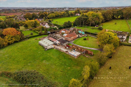
- Price
- Offers Over£600,000
- Size
- 2.48 acres
Added on 14/04/2026House with Land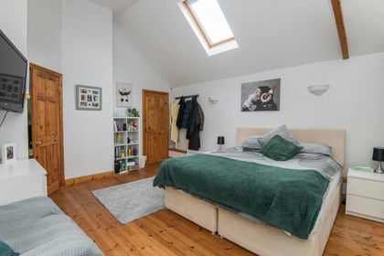
- Price
- Guide Price£870,000
Added on 29/01/2026Barn Conversion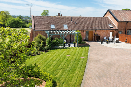
- Price
- Guide Price£625,000
Added on 14/04/2026Barn Conversion
- Price
- Guide Price£795,000
- Size
- 5.37 acres
Added on 24/08/2026House with Land
- Price
- Guide Price£650,000
- Size
- 1.88 acres
Added on 16/07/2026House with Land
- Price
- Guide Price£725,000
- Size
- 1 acres
Added on 18/08/2026House with Land
- Price
- Offers Over£600,000
Westwood Lane, Longdown, Exeter, Devon, Holcombe Burnell, Devon EX6 England
Added on 20/03/2026Barn Conversion
- Price
- Guide Price£850,000
- Size
- 1.2 acres
Church Road, Lympstone, Exmouth, Lympstone, Devon EX8 England
Added on 15/09/2026House with Land
- Price
- Guide Price£900,000
- Size
- 0.37 acres
Barrow Road, Payhembury, Honiton, Devon, EX14, Payhembury, Devon EX14 England
Added on 11/04/2026Barn Conversion