
Lapford, Crediton, EX17
- Land size
- 6.72 acres
- Dwelling size
- 1,818 sq ft
- Bedrooms
- 3
- Bathrooms
- 3
Key Features
- Traditional farmhouse for refurbishment
- Buildings with potential STP
- Land extending to 6.72 acres
- Further land possibly available by separate negotiation
Description
A traditional farmstead requiring renovation, centred on a Grade II listed farmhouse, along with a traditional courtyard of barns. Set within 6.72 acres, with further land possibly available by separate negotiation.
A rare opportunity to purchase a traditional farmstead requiring renovation, accessed via a shared private trackway, centred on a Grade II listed farmhouse, along with a traditional
DESCRIPTION
Rensey Farm comprises a traditional Devon farmhouse and range of farm buildings in a quiet and unspoilt pocket of Mid Devon, close to Lapford.
The property offers an exciting opportunity to restore a traditional rural holding in a rural yet accessible location, within easy reach of Crediton, Tiverton and Exeter.
The farmhouse is of cob and stone construction beneath a pitched (assumed asbestos) roof and retains a number of period features.
The accommodation briefly comprises:
Ground Floor: Kitchen/Breakfast oom with Rayburn Royale range cooker and secondary spiral staircase; Sitting/Dining Room with inglenook fireplace and woodburning stove; Bathroom; Inner Lobby; Walk-in Larder; Pantry/Former Dairy; and Utility/Boot Room with access to an outside WC.
First Floor: Landing; three Bedrooms; Secondary Landing with airing cupboard and spiral staircase to the kitchen; and an additional First Floor Room above an adjoining outbuilding, offering potential for a variety of ancillary uses, subject to any necessary consents.
Farm Buildings
Arranged around a traditional courtyard and hardstanding yard areas, the buildings comprise:
Building 1: Former shippen and stores of stone and cob construction, adjoining the farmhouse with loft over.
Building 2: Traditional stone and cob building with loft over.
Building 3: Open-fronted stone and cob building comprising a former Linhay with loft over.
Building 4: Former roundhouse of stone and cob construction with loft over.
Building 5: Original cider house of stone and cob construction, adjoining the farmhouse, with a part mezzanine loft.
Building 6: Lean-to workshop of brick and cob construction.
Building 7: Garage of block and timber construction.
Building 8: Lean-to machinery store with part stone, brick and block walls.
Building 9: Former block built dairy building.
The traditional buildings offer extensive scope for refurbishment, adaptation or alternative uses. subject to obtaining any necessary consents.
ADDITIONAL INFORMATION
Mobile: Available via EE, O2, THREE and VODAFONE. For an indication of specific speeds and supply or coverage in the area we recommend contacting your own provider.
Broadband: Broadband is available.
Services & Outgoings: We understand that mains electricity are
connected to the property. The property is
served by a private drainage system (this is
assumed to be non-compliant with the current
General Binding Rules) and a private water
supply.
The property is heated by a woodburning stove
and range solid fuel cooker with back boiler.
Local Authority & Council Tax: Council Tax: Band C - Mid Devon District
Council.
Flooding: According to data from the Environment Agency, the farmstead is at a very low risk from River/Sea and Surface Water flooding (defined as the chance of flooding each year as less than 0.1%). Parts of the holding are at a high risk of flooding from Surface Water flooding (defined as the chance of flooding each year as more than 3.3%).
Construction: Construction details to the extent known are detailed within these particulars. It is assumed that some of the building structures may contain asbestos, but this has not been tested or
verified. Prospective purchasers are advised to
make their own investigations/enquiries if any
construction element/s are of concern.
Access: Access is by way of a private, shared hardened track, which extends to approximately 0.87 miles from the nearest adopted highway to the northeast of Rensey farm.
Rights & Restrictions: The property is sold subject to and with the benefit of all rights, easements, wayleaves, covenants, restrictions and obligations, whether public or private, and whether referred to in these particulars or not.
Sporting & Mineral Rights: It is understood that the sporting and mineral rights are in hand and will be included with the freehold.
SITUATION
Rensey Farm occupies a quiet, rural position within the parish of Lapford, set amongst the
rolling farmland and countryside typical of this unspoilt part of Mid Devon. The nearby village
of Lapford provides a good range of day-to-day amenities including a primary school, village
shop, public house, church, village hall and railway station on the scenic Tarka Line, offering
connections to Exeter and Barnstaple.
A wider range of shopping, educational and recreational facilities can be found in the nearby
towns of Crediton, South Molton and Tiverton, whilst the Cathedral City of Exeter lies
approximately 18 miles to the south-east. Exeter offers an extensive range of commercial,
educational and leisure amenities, together with mainline rail connections and Exeter Airport
providing domestic and international flights.
The surrounding countryside provides excellent opportunities for walking, riding and other
outdoor pursuits. Both Dartmoor National Park and Exmoor National Park are readily
accessible, offering further opportunities for enjoying the Devon countryside.
The property benefits from convenient road links via the A377 and nearby A361 North Devon
Link Road, providing access to Exeter, the M5 motorway, North Devon and the wider national
road network.
DIRECTIONS
WhatThreeWords: ///swerving.adopt.gambles
v.1.1 - produced 03/11/2026 - Ref. TIV260225
DISCLAIMER & IMPORTANT INFORMATION
Greenslade Taylor Hunt, their clients and any joint agents give notice that:
They are not authorised to make or give any representations or warranties in relation to the property either here or elsewhere, either on their own behalf or on behalf of their client or otherwise. They assume no responsibility for any statement that may be made in these particulars. These particulars do not form part of any offer or contract and must not be relied upon as statements or representations of fact.
For clarification we wish to inform any prospective purchasers that whilst we endeavour to make our sales particulars as accurate and reliable as possible, they have been prepared as a general guide. If there are any points which are of particular importance to you, please contact the office, especially if you are contemplating travelling some distance to view the property.
Any areas, measurements or distances are approximate and any room sizes provided
should not be relied upon for carpets or furnishings. The text, photographs and plans
are for guidance only and are not necessarily comprehensive. Any field numbers and areas shown on the attached plan are based on the Ordnance Survey and are for identification purposes only. They do not necessarily correspond either with the National Grid plan numbers or with those produced on the Rural Land Register.
It should not be assumed that the property has all necessary planning, building regulation or other consents and Greenslade Taylor Hunt has not carried out a detailed survey, tested any services, equipment, facilities or appliances. Purchasers must satisfy themselves by inspection or otherwise.
We have not made any investigations into the existence or otherwise of any issues
concerning pollution of land, air or water contamination and the purchaser is responsible
for making their own enquiries in this regard.
VIEWING HEALTH & SAFETY POLICY
In accordance with our Health and Safety policy all parties undertaking viewings do so at their own risk. In the event of the property being a site with associated risks/renovation requirements, and if so directed by a member of GTH viewers must wear their own appropriate Personal Protection Equipment (PPE).
Viewers must be vigilant when viewing working farms/land, particularly around the farmyard and in fields containing stock. All potential purchasers are asked to observe the country code and close all gates.
If interested parties do not adhere to our policy and view the site unaccompanied (or without PPE) we/the seller cannot be held liable for any Damage or personal injury or associated claim for compensation.
Map Location
Property details
- Tenure
- Ask Agent
- Council Tax Band
- Ask Agent
- Date Posted
- 2026-11-19
Market Value Analysis
Compared with 148 Farms & Smallholdings listings in South West England (5+ acres).
Energy Performance Certificate
Energy Efficiency Rating
Based on UK Energy Performance Certificate standards (EU Directive 2002/91/EC)
Running costs are one side. Planning activity, flood history and ground risks for this location are in the full report.
Utilities & Restrictions
Utilities
- Electricity
- Ask Agent
- Water
- Ask Agent
- Heating
- Ask Agent
- Broadband
- Ask Agent
- Sewerage
- Ask Agent
Rights & Restrictions
- Public Rights of Way
- Ask Agent
- Private Rights of Way
- Ask Agent
- Listed Property
- Ask Agent
- Restrictions
- Ask Agent
Listed status, conservation areas and planning constraints for this location are in the full report.
Property Features
- Accessibility
- Ask Agent
- Parking
- Ask Agent
- Garden
- Ask Agent
Beyond the particulars: planning activity, flood history, heritage and ground risks, checked for this exact spot.
Connectivity
Broadband
Fastest speed available at this postcode
1.8 Gbps
Standard (10-30 Mbps)
Suitable for
- 4K streaming on every screen
- Full-time home working
- Online gaming & big downloads
Fixed wireless access may also be an option here.
Mobile signal
Predicted 4G and 5G signal; indoor signal depends on building materials.
Ofcom Connected Nations postcode-level predictions. Speeds and signal are modelled, not measured, and vary between addresses and providers.
Signal is the easy part. Planning activity, flood history and protected designations here are in the full report.
Nearest Schools
Primary
- St Thomas of Canterbury CofE Primary School999 metresOfsted report card · Jun 2026
- Ages
- 2 to 11
- Pupils
- 51
- Type
- Academy converter
- Faith
- Anglican/Church of England
- Morchard Bishop Church of England Primary School3 milesNo Ofsted rating
- Ages
- 2 to 11
- Pupils
- 101
- Type
- Academy converter
- Faith
- Church of England
- East Worlington Primary School4 milesNo Ofsted rating
- Ages
- 0 to 11
- Pupils
- 75
- Type
- Academy converter
- Chulmleigh Primary School4.2 milesOfsted: Good
- Ages
- 2 to 11
- Pupils
- 226
- Type
- Academy converter
- Copplestone Primary School4.8 milesOfsted: Good
- Ages
- 4 to 11
- Pupils
- 138
- Type
- Foundation school
Secondary
- Chulmleigh Community College4.2 milesNo Ofsted rating
- Ages
- 11 to 16
- Pupils
- 735
- Type
- Academy converter
- Queen Elizabeth's8.2 milesOfsted report card · May 2026
- Ages
- 11 to 18
- Pupils
- 1,096
- Type
- Academy converter
- South Molton Community College10 milesOfsted: Good *
- Ages
- 11 to 16
- Pupils
- 656
- Type
- Foundation school
- Okehampton College12 milesOfsted report card · Jan 2026
- Ages
- 11 to 18
- Pupils
- 1,066
- Type
- Academy converter
- Tiverton High School14 milesOfsted: Inadequate *
- Ages
- 11 to 16
- Type
- Academy sponsor led
* Latest graded judgement covers quality of education only; no overall grade was issued under the 2024-25 inspection framework.
Distances are straight-line from the advertised location. Source: the national school registers (DfE, Welsh Government, Scottish Government) and Ofsted.
Schools are just the start: sold prices nearby, planning activity and any flood history are in the full report.
Amenities
Supermarket
GP surgery
Pharmacy
Hospital
Green space
Straight-line distances from the advertised location. Sources: NHS records, Geolytix supermarket locations, OS Open Greenspace and the national trails registers.
The area stacks up? Now check the location itself: planning nearby, protected designations and past flooding.
Getting Around
Nearest station
Nearest bus stop
Typical drive times
Straight-line distances from the advertised location; drive times are typical free-flow times over OpenStreetMap road data, so allow more at peak. Public transport locations from DfT NaPTAN.
Easy to reach matters. So do planning activity, flood history and ground risks: all in the full report.
Flood Risk
Environment Agency open data, checked around the advertised map pin for the listed acreage. Long-term risk counts flood defences; the planning map's flood zones do not. Provided by LandSale, not the listing agent, and not part of the agent's particulars. Risk varies across a holding, so verify before committing.
Rivers and the sea
Planning map: Flood Zone 1.
Surface water
Not at the pin: mapped about 40 metres away.
These bandings are the summary. Where this location sits on the flood maps, plus planning activity, heritage and ground risks, is in the full report.
Important notice: Information, maps and tags on this page are drawn from the advertising agent's marketing materials or generated automatically. LandSale has not verified them. Relying on these details is at your own risk, always carry out independent checks before committing to a purchase.
LandSale full disclaimer
Marketing information only - not formal particulars. The details on this website are provided for general guidance and do not constitute an offer or contract. Neither LandSale nor the advertising estate/land agent accepts responsibility for any inaccuracy.
1. Source of information
- Listing content: Core description, asking price, tenure, measurements, photographs and planning history originate from the marketing materials of the advertising estate or land agent. LandSale does not author this content and cannot guarantee its accuracy.
- Automated tags & categorisation: Property type, land-use class, acreage bands and similar labels may be applied by machine-learning models. They are intended as a helpful guide only and may not reflect the property's legal status or permitted use.
- Third-party & enriched data layers: Maps, boundary outlines, planning designations, soil reports, broadband coverage and other environmental or location-based insights are licensed from external suppliers. Such data are supplied “as is", may be incomplete or out of date and are subject to change without notice.
2. Verification required
Prospective purchasers must verify critical matters, including but not limited to planning permission, title boundaries, public rights of way, environmental constraints, acreage, services, access and VAT status, through their own inspections, specialist surveys, legal advisers and the selling agent before relying on the information or entering into any contract.
3. No warranty or liability
LandSale gives no warranty, express or implied, as to the accuracy, completeness or fitness for any particular purpose of the information displayed. LandSale shall not be liable for any loss, damage, cost or expense arising directly or indirectly from any use of or reliance on such information, save where liability may not be excluded by law.
4. Updates & feedback
If you believe any detail on this listing is inaccurate, please let us know. We will investigate and, where appropriate, update the listing or notify the agent.
© LandSale | Version 1.3 - August 2026
Similar properties for sale
- Price
- Guide Price£380,000
- Size
- 34.68 acres
Station Farm - Lot 4, 34.68 Acres - Bow, Crediton, EX17, Crediton, Devon EX17 England
Added on 05/06/2026Agricultural Land
- Price
- Offers in Region of£400,000
- Size
- 11 acres
Added on 24/06/2026Smallholding
- Price
- Offers in Region of£495,000
- Size
- 6 acres
Added on 17/03/2026Smallholding
- Price
- £550,000
- Size
- 3.33 acres
Llwynrhyddid Farmhouse, Hensol, Pontyclun, CF72, Pendoylan, Vale of Glamorgan CF72 Wales
Added on 29/01/2026Smallholding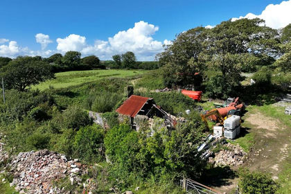
- Price
- Offers in Region of£499,995
- Size
- 5.6 acres
Added on 20/02/2026Building Plot
- Price
- Guide Price£550,000
- Size
- 3.02 acres
1, Landraw Road Pontypridd CF37, Pontypridd Town, Rhondda Cynon Taf CF37 Wales
Added on 09/09/2026Smallholding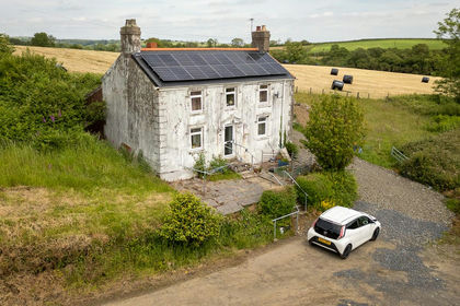
- Price
- Offers in Region of£475,000
- Size
- 9.08 acres
Furnace, Nr Llanelli, SA15, Llanelli, Carmarthenshire SA15 Wales
Added on 06/07/2026Smallholding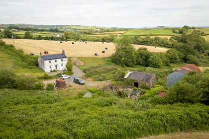
- Price
- Offers in Region of£475,000
- Size
- 9.08 acres
Felinfoel, Llanelli, SA15, Llanelli, Carmarthenshire SA15 Wales
Added on 13/07/2026Smallholding