
South Wongs Farm, Tickhill, Nr Doncaster
- Land size
- 4.94 acres
- Bedrooms
- 4
- Bathrooms
- 1
Key Features
- Never previously sold
- Traditional farm buildings with potential
- Detached farmhouse to modernise
- General purpose agricultural buildings
- Country setting on Sandbeck Estate
- Long distance rural views
- Good road and rail connections
- Unique opportunity
Description
An impressive 4 bedroom detached farmhouse of some 3400 sq ft requiring modernisation, a substantial range of traditional farm buildings of almost 8000 sq ft with development potential and general purpose agricultural buildings of around 4700 sq ft, all standing in around 5 acres on the edge of the Sandbeck Estate.
Situation - South Wongs Farm is located on the northern edge of the historic Sandbeck Estate and takes full advantage of its rural setting surrounded by open countryside. The appealing rural situation belies its convenience, close to the South Yorkshire/Nottinghamshire border and a short distance from the A60, some 11 miles south of Doncaster. The A1 (M) junction at Blyth is a 10 minute drive offering excellent road accessibility further afield, with East Coast mainline rail connections at Doncaster and Retford . The region’s commercial centres, particularly Sheffield, are within comfortable commuting distance.
Description - It is understood South Wongs Farm was constructed by The Estate in the C18 century, and is offered for sale for the first time following the retirement of a long-standing agricultural tenant.
Comprising one lot and standing in around 4.94 acres bordering estate farmland, this unique property will appeal to a wide range of potential purchasers.
The detached predominantly stone build farmhouse has extensive accommodation, currently comprising four double bedrooms and three reception rooms, it is arranged over two floors and extending to some 3395 sq ft. Now in need of modernisation, there is also potential to convert attic rooms into further bedroom accommodation if required. The farmhouse is served by a useful brick outhouse.
There is a significant range of traditional stone farm buildings that would readily convert to residential use (subject to appropriate consents). The buildings incorporate an impressive stone barn, two-storey granary with three-bays plus workshop and garage, and a stable courtyard comprising six boxes, tack room, two stores, and covered yard with lean-to storage to the rear. There is also a four bay open garage/carport for numerous vehicles. Overall, the traditional farm buildings extend to some 7865 sq ft.
To the north are two general purpose agriculture buildings, accessed via a separate agricultural entrance and latterly used for grain storage, but suitable for a variety of uses (subject to appropriate consents) and extending overall to some 4680 sq ft.
There is a pleasant south facing outlook to the front of the farmhouse, an enclosed vegetable garden with greenhouse, and gently sloping grazing paddock beyond, with the holding overall being some 4.94 acres.
Tenure - Freehold with vacant possession on legal completion. The sporting and mineral rights are excluded from the sale.
Mode Of Sale - The property for sale as a whole as one lot. The vendor’s preference is an outright sale, although consideration would be given to proposals that are subject to planning. In any event the vendor does reserve the right to include a clawback provision relating to planning permission that might be granted for alternative use(s) in the future.
Development Potential - Preliminary enquiries have been made of the local authority with further information available from the selling agents.
Services - Mains electricity. Oil central heating. Mains water via a metered private supply billed quarterly by The Estate. Private drainage currently to a septic tank which will require replacement. No mains gas. Interested parties should make their own inquiries of the relevant providers.
Easements And Rights Of Way - The property is sold subject to and with the benefit of all existing wayleaves, easements, and rights of way, public and private, whether specifically mentioned or not.
Local Authority And Council Tax - Doncaster Council. Tax Band F.
What3words - ///employ.prevented.unstated
Directions - At the crossroads in Oldcotes, proceed north on the A60 towards Doncaster. After 0.75 miles, turn left onto Blyth Gate Lane. After 0.25 miles the property will be seen on the left hand side.
Viewings Arrangements - Strictly by appointment through GSC Grays
Disclaimer - GSC Grays gives notice that:
1. These particulars are a general guide only and do not form any part of any offer or contract.
2. All descriptions, including photographs, dimensions and other details are given in good faith but no warranty is provided. Statements made should not be relied upon as facts and anyone interested must satisfy themselves as to their accuracy by inspection or otherwise.
3. Neither GSC Grays nor the vendors accept responsibility for any error that these particulars may contain however caused.
4. Any plan is for guidance only and is not drawn to scale. All dimensions, shapes, and compass bearings are approximate and should not be relied upon without checking them first.
5. Nothing in these particulars shall be deemed to be a statement that the property is in good condition, repair or otherwise nor that any services or facilities are in good working order.
6. Please discuss with us any aspects that are important to you prior to travelling to the property.
Particulars And Photography - Particulars written: October 2026. Photography taken: October 2026
Map Location
Property details
- Tenure
- Freehold
- Council Tax Band
- F
- Date Posted
- 2026-11-16
Market Value Analysis
Compared with 599 Homes with Land listings in Yorkshire and The Humber (1+ acres).
Energy Performance Certificate
Energy Efficiency Rating
Based on UK Energy Performance Certificate standards (EU Directive 2002/91/EC)
Running costs are one side. Planning activity, flood history and ground risks for this location are in the full report.
Utilities & Restrictions
Utilities
- Electricity
- Mains
- Water
- Mains
- Heating
- Oil Heating
- Broadband
- Ask Agent
- Sewerage
- Septic Tank / Private
Rights & Restrictions
- Public Rights of Way
- Ask Agent
- Private Rights of Way
- Ask Agent
- Listed Property
- Ask Agent
- Restrictions
- Ask Agent
Listed status, conservation areas and planning constraints for this location are in the full report.
Property Features
- Accessibility
- Ask Agent
- Parking
- Parking Available
- Garden
- Garden
Beyond the particulars: planning activity, flood history, heritage and ground risks, checked for this exact spot.
Connectivity
Broadband
Fastest speed available at this postcode
5 Mbps
Under 10 Mbps here
Suitable for
- Basic browsing & email
Mobile signal
Predicted 4G and 5G signal; indoor signal depends on building materials.
Ofcom Connected Nations postcode-level predictions. Speeds and signal are modelled, not measured, and vary between addresses and providers.
Signal is the easy part. Planning activity, flood history and protected designations here are in the full report.
Nearest Schools
Primary
- Tickhill St Mary's Church of England Primary and Nursery School1.3 milesOfsted report card · Jan 2026
- Ages
- 3 to 11
- Pupils
- 226
- Type
- Voluntary aided school
- Faith
- Church of England
- Tickhill Estfeld Primary School1.8 milesOfsted: Good
- Ages
- 4 to 11
- Pupils
- 218
- Type
- Community school
- Harworth Church of England Academy2.2 milesNo Ofsted rating
- Ages
- 4 to 11
- Pupils
- 210
- Type
- Academy converter
- Faith
- Church of England
- Langold Dyscarr Community School2.4 milesOfsted: Good
- Ages
- 3 to 11
- Pupils
- 334
- Type
- Academy sponsor led
- St Patrick's Catholic Primary School2.8 milesOfsted: Good
- Ages
- 3 to 11
- Pupils
- 134
- Type
- Academy converter
- Faith
- Roman Catholic
Secondary
- Serlby Park Academy2.9 milesOfsted: Good
- Ages
- 3 to 16
- Pupils
- 991
- Type
- Academy sponsor led
- Maltby Academy3.7 milesOfsted report card · Apr 2026
- Ages
- 11 to 19
- Pupils
- 1,096
- Type
- Academy sponsor led
- Rossington All Saints Academy4.4 milesOfsted: Good
- Ages
- 11 to 16
- Pupils
- 850
- Type
- Academy sponsor led
- Faith
- Church of England
- Dinnington High School4.4 milesOfsted: Requires improvement
- Ages
- 11 to 18
- Pupils
- 1,005
- Type
- Academy converter
- Sir Thomas Wharton Academy4.9 milesOfsted report card · Mar 2026
- Ages
- 11 to 18
- Pupils
- 1,226
- Type
- Academy converter
Distances are straight-line from the advertised location. Source: the national school registers (DfE, Welsh Government, Scottish Government) and Ofsted.
Schools are just the start: sold prices nearby, planning activity and any flood history are in the full report.
Amenities
Supermarket
GP surgery
Pharmacy
Hospital
Straight-line distances from the advertised location. Sources: NHS records, Geolytix supermarket locations, OS Open Greenspace and the national trails registers.
The area stacks up? Now check the location itself: planning nearby, protected designations and past flooding.
Getting Around
Nearest station
Nearest bus stop
Typical drive times
Straight-line distances from the advertised location; drive times are typical free-flow times over OpenStreetMap road data, so allow more at peak. Public transport locations from DfT NaPTAN.
Easy to reach matters. So do planning activity, flood history and ground risks: all in the full report.
Flood Risk
Environment Agency open data, checked around the advertised map pin for the listed acreage. Long-term risk counts flood defences; the planning map's flood zones do not. Provided by LandSale, not the listing agent, and not part of the agent's particulars. Risk varies across a holding, so verify before committing.
Rivers and the sea
Planning map: Flood Zone 1.
Surface water
These bandings are the summary. Where this location sits on the flood maps, plus planning activity, heritage and ground risks, is in the full report.
Important notice: Information, maps and tags on this page are drawn from the advertising agent's marketing materials or generated automatically. LandSale has not verified them. Relying on these details is at your own risk, always carry out independent checks before committing to a purchase.
LandSale full disclaimer
Marketing information only - not formal particulars. The details on this website are provided for general guidance and do not constitute an offer or contract. Neither LandSale nor the advertising estate/land agent accepts responsibility for any inaccuracy.
1. Source of information
- Listing content: Core description, asking price, tenure, measurements, photographs and planning history originate from the marketing materials of the advertising estate or land agent. LandSale does not author this content and cannot guarantee its accuracy.
- Automated tags & categorisation: Property type, land-use class, acreage bands and similar labels may be applied by machine-learning models. They are intended as a helpful guide only and may not reflect the property's legal status or permitted use.
- Third-party & enriched data layers: Maps, boundary outlines, planning designations, soil reports, broadband coverage and other environmental or location-based insights are licensed from external suppliers. Such data are supplied “as is", may be incomplete or out of date and are subject to change without notice.
2. Verification required
Prospective purchasers must verify critical matters, including but not limited to planning permission, title boundaries, public rights of way, environmental constraints, acreage, services, access and VAT status, through their own inspections, specialist surveys, legal advisers and the selling agent before relying on the information or entering into any contract.
3. No warranty or liability
LandSale gives no warranty, express or implied, as to the accuracy, completeness or fitness for any particular purpose of the information displayed. LandSale shall not be liable for any loss, damage, cost or expense arising directly or indirectly from any use of or reliance on such information, save where liability may not be excluded by law.
4. Updates & feedback
If you believe any detail on this listing is inaccurate, please let us know. We will investigate and, where appropriate, update the listing or notify the agent.
© LandSale | Version 1.3 - August 2026
Listing agent
GSC Grays, Farm Agency5-6 Bailey Court, Colburn Business Park, Catterick Garrison, DL9 4QL
Contact GSC Grays, Farm Agency
5-6 Bailey Court, Colburn Business Park, Catterick Garrison, DL9 4QL
View agent profileSimilar properties for sale
- Price
- Offers in Region of£795,000
- Size
- 6 acres
The Stables, 45 Lindrick Road, Woodsetts, Woodsetts, Rotherham S81 England
Added on 24/09/2026Equestrian property
- Price
- £799,500
- Size
- 4 acres
Moor View, Aston Common, Sheffield, S26, Aston cum Aughton, Rotherham S26 England
Added on 22/06/2026House with Land
- Price
- £900,000
- Size
- 4 acres
John Hibbard Avenue, Sheffield, Sheffield South East, Sheffield S13 England
Added on 03/04/2026House with Land
- Price
- £690,000
- Size
- 4.75 acres
Added on 01/10/2026Smallholding
- Price
- £575,000
- Size
- 2.6 acres
Double Bridges Road, Thorne, DN8, Thorne, Doncaster DN8 England
Added on 20/07/2026House with Land
- Price
- £625,000
- Size
- 15 acres
Added on 28/04/2026Farmhouse
- Price
- £750,000
- Size
- 3.76 acres
Main Street, Kirton, Newark, Kirton, Nottinghamshire NG22 England
Added on 28/03/2026House with Land
- Price
- Offers in Region of£795,000
- Size
- 7 acres
Sykehouse SOUTH YORKSHIRE, Sykehouse, Doncaster DN14 England
Added on 08/10/2026House with Land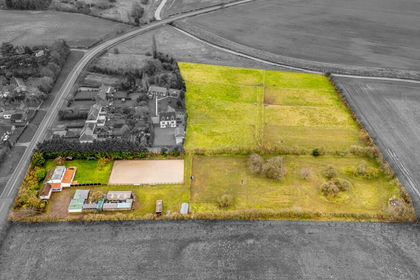
- Price
- £650,000
- Size
- 5.74 acres
High Street, Marton, Gainsborough, Lincolnshire, DN21, Marton, Lincolnshire DN21 England
Added on 31/05/2026Equestrian property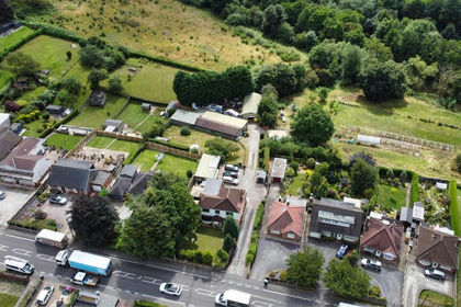
- Price
- £675,000
- Size
- 13.5 acres
The Hill, Glapwell, Chesterfield, Glapwell, Derbyshire S44 England
Added on 28/08/2026House with Land