19 20 Woodgate Way, Glenrothes, KY7
- Floor area
- 3,092 sq ft
- Use Class
- Use Classes: 5, 6
Key Features
- Part income producing industrial investment
- Well located workshop/warehouse units
- On-site parking available
- Unit 19 is let and offers in excess of £135,000 plus VAT invited
- Unit 20 is available to lease at £12,500 plus VAT or to purchase with offers in excess of £125,000 plus VAT invited
Description
The subjects comprise 2 adjoining steel framed industrial units finished to the following specification:
• Profiled metal sheet roof incorporating approximately 10% translucent light panels
• Fluorescent tube lighting
• 3 phase power supply
• Gas fired hot air blower to warehouse
• Sectional loading door to each unit measuring approximately 3.23m wide x 3.02m high
• Office accommodation
• Staff WC
• Maximum eaves height approximately 3.92 metres
• Communal loading yard and parking
Location
Glenrothes is a former New Town and is one of Fife’s principal centres of population, occupying a central location within the region and having a resident population in the order of 40,000.
The town is the administrative centre for Fife and provides the industrial nucleus, containing an extensive stock of commercial units.
Eastfield Industrial Estate lies on the south-eastern corner of Glenrothes, approximately 1 minute’s drive from the Bankhead Roundabout that provides direct access to the A92 and in turn the M90, linking to Dunfermline, Kirkcaldy and Dundee.
The subjects lie on the southern edge of Eastfield Industrial Estate. Woodgate Way South is accessed via Woodside Way, the main road through the estate. Nearby occupiers include Howdens, D&G Autocare and The Paint Shed.
Terms
Sale Terms
Unit 19 was taken on an initial lease in July 2022 that has continued on an annual basis at a rent of £12,500 per annum. Our client is seeking offers in excess of £135,000 plus VAT for the benefit of their interest in the subjects. Unit 20 is currently vacant and offers in excess of £125,000 plus VAT are sought.
The subjects are held on a ground lease expiring on 27th August 2114 at an annual rent of £100 per annum plus VAT. Further details and a copy of the lease document are available on request.
Lease Terms
Unit 20 is available to lease on full repairing and insuring terms at a rent of £12,500 per annum.
Map Location
Property details
- Tenure
- Freehold
- Council Tax Band
- Ask Agent
- Date Posted
- 2026-11-11
Utilities & Restrictions
Utilities
- Electricity
- Ask Agent
- Water
- Ask Agent
- Heating
- Ask Agent
- Broadband
- Ask Agent
- Sewerage
- Ask Agent
Rights & Restrictions
- Public Rights of Way
- Ask Agent
- Private Rights of Way
- Ask Agent
- Listed Property
- Ask Agent
- Restrictions
- Ask Agent
Listed status, conservation areas and planning constraints for this location are in the full report.
Property Features
- Accessibility
- Ask Agent
- Parking
- Ask Agent
- Garden
- Ask Agent
Beyond the particulars: planning activity, flood history, heritage and ground risks, checked for this exact spot.
Connectivity
Broadband
Fastest speed available at this postcode
80 Mbps
Superfast
Suitable for
- HD streaming
- Video calls
- Web & social
Mobile signal
Predicted 4G and 5G signal; indoor signal depends on building materials.
Ofcom Connected Nations postcode-level predictions. Speeds and signal are modelled, not measured, and vary between addresses and providers.
Signal is the easy part. Planning activity, flood history and protected designations here are in the full report.
Nearest Schools
Primary
- Carleton Primary School565 metres
- Pupils
- 338
- Type
- Non-denominational
- Pitteuchar East Primary School759 metres
- Pupils
- 225
- Type
- Non-denominational
- Pitteuchar West Primary School0.7 miles
- Pupils
- 257
- Type
- Non-denominational
- Coaltown Of Balgonie Primary School0.8 miles
- Pupils
- 100
- Type
- Non-denominational
- Warout Primary & Community School1 mile
- Pupils
- 195
- Type
- Non-denominational
Secondary
- Auchmuty High School0.7 miles
- Pupils
- 1,302
- Type
- Non-denominational
- Glenrothes High School1.8 miles
- Pupils
- 830
- Type
- Non-denominational
- Glenwood High School2.3 miles
- Pupils
- 876
- Type
- Non-denominational
- St Andrew's R C High School3.7 miles
- Pupils
- 867
- Type
- Roman Catholic
- Kirkcaldy High School3.8 miles
- Pupils
- 1,469
- Type
- Non-denominational
Distances are straight-line from the advertised location. Source: the national school registers (DfE, Welsh Government, Scottish Government) and Ofsted.
Schools are just the start: planning activity, heritage and any flood history here are in the full report.
Amenities
Supermarket
GP surgery
Pharmacy
Green space
Walking trail
Straight-line distances from the advertised location. Sources: NHS records, Geolytix supermarket locations, OS Open Greenspace and the national trails registers.
The area stacks up? Now check the location itself: planning nearby, protected designations and past flooding.
Getting Around
Nearest station
Nearest bus stop
Typical drive times
Straight-line distances from the advertised location; drive times are typical free-flow times over OpenStreetMap road data, so allow more at peak. Public transport locations from DfT NaPTAN.
Easy to reach matters. So do planning activity, flood history and ground risks: all in the full report.
Flood Risk
SEPA open data, checked around the advertised map pin for the listed acreage. The map pin for this listing is approximate, so these readings describe the surrounding area. Provided by LandSale, not the listing agent, and not part of the agent's particulars. Risk varies across a holding, so verify before committing.
Rivers and the sea
Surface water
These bandings are the summary. Where this location sits on the flood maps, plus planning activity, heritage and ground risks, is in the full report.
Important notice: Information, maps and tags on this page are drawn from the advertising agent's marketing materials or generated automatically. LandSale has not verified them. Relying on these details is at your own risk, always carry out independent checks before committing to a purchase.
LandSale full disclaimer
Marketing information only - not formal particulars. The details on this website are provided for general guidance and do not constitute an offer or contract. Neither LandSale nor the advertising estate/land agent accepts responsibility for any inaccuracy.
1. Source of information
- Listing content: Core description, asking price, tenure, measurements, photographs and planning history originate from the marketing materials of the advertising estate or land agent. LandSale does not author this content and cannot guarantee its accuracy.
- Automated tags & categorisation: Property type, land-use class, acreage bands and similar labels may be applied by machine-learning models. They are intended as a helpful guide only and may not reflect the property's legal status or permitted use.
- Third-party & enriched data layers: Maps, boundary outlines, planning designations, soil reports, broadband coverage and other environmental or location-based insights are licensed from external suppliers. Such data are supplied “as is", may be incomplete or out of date and are subject to change without notice.
2. Verification required
Prospective purchasers must verify critical matters, including but not limited to planning permission, title boundaries, public rights of way, environmental constraints, acreage, services, access and VAT status, through their own inspections, specialist surveys, legal advisers and the selling agent before relying on the information or entering into any contract.
3. No warranty or liability
LandSale gives no warranty, express or implied, as to the accuracy, completeness or fitness for any particular purpose of the information displayed. LandSale shall not be liable for any loss, damage, cost or expense arising directly or indirectly from any use of or reliance on such information, save where liability may not be excluded by law.
4. Updates & feedback
If you believe any detail on this listing is inaccurate, please let us know. We will investigate and, where appropriate, update the listing or notify the agent.
© LandSale | Version 1.3 - August 2026
Listing agent
DM Hall LLP, EdinburghContact DM Hall LLP, Edinburgh
View agent profileSimilar properties for sale
- Price
- POA
- Size
- 8.4 acres
Development Site, Nairn Street, Kirkcaldy, Fife, KY1, Cowdenbeath and Kirkcaldy, Fife KY1 Scotland
Added on 29/01/2026Commercial Land
- Price
- Offers in Excess of£95,000
44 Randolph Street, Buckhaven, Fife, KY8, Glenrothes and Mid Fife, Fife KY8 Scotland
Added on 09/06/2026Pub
- Price
- £250,000
- Floor area
- 3,963 sq ft
8 Low Road, Auchtermuchty, Fife, North East Fife, Fife KY14 Scotland
Added on 29/09/2026Industrial Land
- Price
- POA
- Floor area
- 25,294 sq ft
250 Broad Street, Cowdenbeath, KY48JE, Cowdenbeath and Kirkcaldy, Fife KY4 Scotland
Added on 20/05/2026Warehouse
- Price
- POA
- Floor area
- 13,477 sq ft
Front Lebanon, Cupar, KY15, North East Fife, Fife KY15 Scotland
Added on 29/01/2026Industrial Land
- Price
- POA
- Size
- 0.68 acres
Front Lebanon, Cupar, KY15, North East Fife, Fife KY15 Scotland
Added on 29/01/2026Development Land
- Price
- POA
- Floor area
- 34,144 sq ft
Added on 26/10/2026Industrial Land
- Price
- Offers in Excess of£350,000
- Floor area
- 4,961 sq ft
Added on 06/11/2026Industrial Land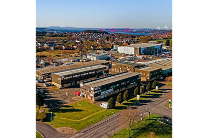
- Price
- Offers in Excess of£575,000
- Floor area
- 8,880 sq ft
Added on 06/11/2026Industrial Land Added on 25/08/2026Pub