
Mabie Farm Park, Mabie, Dumfries, Dumfries And Galloway
- Land size
- 54 acres
Key Features
- Profitable established business
- 54 acre park
- Year-round trading potential
- Strong visitor reputation
- Multiple income streams
- Lodge development opportunity
- Two residential properties
- Additional land available by negotiation
Description
Mabie Farm Park represents a rare opportunity to acquire a highly profitable, well-established and much-loved visitor attraction, extending to approximately 54 acres, offered for sale as a going concern. Combining a strong existing income stream with clear and tangible opportunities for expansion, the property will appeal to owner-operators, investors, and those seeking a scalable tourism business within a thriving holiday destination.
Location and Situation
The property enjoys a prime trading position just south of Dumfries, close to the Solway Firth coastline and adjacent to Mabie Forest, an area renowned for outdoor recreation and tourism. The region attracts significant visitor numbers throughout the year, supported by nearby holiday parks, caravan sites, and a wide range of tourist attractions.
Accessibility is a key strength, with the property located within approximately two hours’ drive of Glasgow, Edinburgh, Carlisle, and Newcastle upon Tyne. Dumfries, a short distance away, provides a full range of amenities, schooling, and services, ensuring the business is well-positioned to benefit from both local and passing trade.
The Business
Established in 2000, Mabie Farm Park has grown into a highly successful and well-regarded family attraction with strong repeat custom and excellent online reviews. The business currently operates with a diverse and robust income base including admissions, food and beverage sales, retail, events, and animal experiences.
A particular strength of the business is its ability to trade for an extended season, supported by a wide range of indoor and outdoor facilities. There is clear potential for new owners to further enhance profitability by moving towards full year-round operation, increasing indoor capacity, and expanding events programming, private hire, and seasonal attractions.
Facilities and Attractions
The park offers a comprehensive and well-balanced mix of attractions catering to all weather conditions, making it an exceptionally resilient trading operation.
Indoor facilities include a popular straw barn with adventure play features and a modern play barn with climbing structures, toddler areas, seating, and dedicated party rooms. These facilities provide a strong foundation for winter trading and offer immediate scope for expansion through further insulated or themed play areas.
Externally, the park is extensively developed with a wide range of attractions including a toboggan run, boating pond, pedal go-karts, adventure play equipment, jumping pillows, and the well-known Mabie Farm Choo Choo train. The scale and diversity of the offering ensures broad visitor appeal and repeat visits.
Animal attractions remain central to the business, with a wide variety of livestock and small animals, alongside interactive experiences such as feeding, further enhancing visitor engagement and dwell time.
Catering and Retail
A substantial tea room with approximately 120 covers provides a strong secondary income stream and is fully equipped to cater for day visitors, group bookings, parties, and events. The space opens onto an attractive external patio and courtyard, further increasing capacity during peak trading periods.
The reception and farm shop complement the offering, generating additional revenue through retail sales and local produce.
Residential Accommodation
Two high-quality residential properties provide excellent on-site accommodation, ideal for owners, management, or potential holiday letting (subject to consents), creating further income potential.
Burnside Farmhouse is a well-presented traditional farmhouse with five bedrooms and spacious living accommodation, set within private garden grounds.
The Old Barn is a stylish and flexible three-bedroom conversion arranged over three levels, offering modern living within a characterful structure and benefiting from its own enclosed patio area.
Land, Expansion and Development Potential
The property extends to approximately 54 acres, providing significant operational flexibility and capacity for future growth.
A key feature of the offering is the existing planning consent for the development of 10 holiday lodges, together with associated infrastructure. This presents a substantial opportunity for new owners to create a complementary on-site accommodation business, significantly increasing visitor numbers, extending length of stay, and generating additional year-round income streams. The integration of lodge accommodation with the established attraction offers clear potential for enhanced overall profitability and business value.
There is also considerable scope to expand the existing park through additional attractions, enhanced indoor facilities, and further diversification into events, corporate use, and seasonal experiences.
In addition, further adjoining land may be available by separate negotiation, offering additional opportunities for expansion, development, or alternative uses, subject to the necessary consents.
Map Location
Property details
- Tenure
- Freehold
- Council Tax Band
- Ask Agent
- Date Posted
- 2026-11-06
Market Value Analysis
Compared with 32 Farms & Smallholdings listings in Scotland (50+ acres).
Energy Performance Certificate
View the official EPC certificate for detailed energy efficiency information.
View official EPC certificate ↗
Running costs are one side. Planning activity, flood history and ground risks for this location are in the full report.
Property Brochure
Seen the details? The full report adds the independent checks: planning activity, flood history, heritage and ground.
Utilities & Restrictions
Utilities
- Electricity
- Ask Agent
- Water
- Ask Agent
- Heating
- Ask Agent
- Broadband
- Ask Agent
- Sewerage
- Ask Agent
Rights & Restrictions
- Public Rights of Way
- Ask Agent
- Private Rights of Way
- Ask Agent
- Listed Property
- Ask Agent
- Restrictions
- Ask Agent
Listed status, conservation areas and planning constraints for this location are in the full report.
Property Features
- Accessibility
- Ask Agent
- Parking
- Ask Agent
- Garden
- Ask Agent
Beyond the particulars: planning activity, flood history, heritage and ground risks, checked for this exact spot.
Connectivity
Broadband
Fastest speed available at this postcode
1.8 Gbps
Gigabit full fibre · available to 86% of premises
Suitable for
- 4K streaming on every screen
- Full-time home working
- Online gaming & big downloads
Mobile signal
Predicted 4G and 5G signal; indoor signal depends on building materials.
Ofcom Connected Nations postcode-level predictions. Speeds and signal are modelled, not measured, and vary between addresses and providers.
Signal is the easy part. Planning activity, flood history and protected designations here are in the full report.
Nearest Schools
Primary
- Cargenbridge School2.1 miles
- Pupils
- 110
- Type
- Non-denominational
- Brownhall School2.3 miles
- Pupils
- 24
- Type
- Non-denominational
- Troqueer School2.6 miles
- Pupils
- 253
- Type
- Non-denominational
- St Michael's School3 miles
- Pupils
- 168
- Type
- Non-denominational
- Laurieknowe School3.1 miles
- Pupils
- 280
- Type
- Non-denominational
Secondary
- St Joseph's College3.1 miles
- Pupils
- 961
- Type
- Roman Catholic
- Dumfries Academy3.5 miles
- Pupils
- 608
- Type
- Non-denominational
- North West Community Campus3.8 miles
- Pupils
- 302
- Type
- Non-denominational
- Dumfries High School3.9 miles
- Pupils
- 748
- Type
- Non-denominational
- Dalbeattie High School10 miles
- Pupils
- 347
- Type
- Non-denominational
Distances are straight-line from the advertised location. Source: the national school registers (DfE, Welsh Government, Scottish Government) and Ofsted.
Schools are just the start: planning activity, heritage and any flood history here are in the full report.
Amenities
Supermarket
GP surgery
Pharmacy
Green space
Walking trail
Straight-line distances from the advertised location. Sources: NHS records, Geolytix supermarket locations, OS Open Greenspace and the national trails registers.
The area stacks up? Now check the location itself: planning nearby, protected designations and past flooding.
Getting Around
Nearest station
Nearest bus stop
Typical drive times
Straight-line distances from the advertised location; drive times are typical free-flow times over OpenStreetMap road data, so allow more at peak. Public transport locations from DfT NaPTAN.
Easy to reach matters. So do planning activity, flood history and ground risks: all in the full report.
Flood Risk
SEPA open data, checked around the advertised map pin for the listed acreage. Provided by LandSale, not the listing agent, and not part of the agent's particulars. Risk varies across a holding, so verify before committing.
Rivers and the sea
Not at the pin: mapped about 210 metres away.
Surface water
These bandings are the summary. Where this location sits on the flood maps, plus planning activity, heritage and ground risks, is in the full report.
Important notice: Information, maps and tags on this page are drawn from the advertising agent's marketing materials or generated automatically. LandSale has not verified them. Relying on these details is at your own risk, always carry out independent checks before committing to a purchase.
LandSale full disclaimer
Marketing information only - not formal particulars. The details on this website are provided for general guidance and do not constitute an offer or contract. Neither LandSale nor the advertising estate/land agent accepts responsibility for any inaccuracy.
1. Source of information
- Listing content: Core description, asking price, tenure, measurements, photographs and planning history originate from the marketing materials of the advertising estate or land agent. LandSale does not author this content and cannot guarantee its accuracy.
- Automated tags & categorisation: Property type, land-use class, acreage bands and similar labels may be applied by machine-learning models. They are intended as a helpful guide only and may not reflect the property's legal status or permitted use.
- Third-party & enriched data layers: Maps, boundary outlines, planning designations, soil reports, broadband coverage and other environmental or location-based insights are licensed from external suppliers. Such data are supplied “as is", may be incomplete or out of date and are subject to change without notice.
2. Verification required
Prospective purchasers must verify critical matters, including but not limited to planning permission, title boundaries, public rights of way, environmental constraints, acreage, services, access and VAT status, through their own inspections, specialist surveys, legal advisers and the selling agent before relying on the information or entering into any contract.
3. No warranty or liability
LandSale gives no warranty, express or implied, as to the accuracy, completeness or fitness for any particular purpose of the information displayed. LandSale shall not be liable for any loss, damage, cost or expense arising directly or indirectly from any use of or reliance on such information, save where liability may not be excluded by law.
4. Updates & feedback
If you believe any detail on this listing is inaccurate, please let us know. We will investigate and, where appropriate, update the listing or notify the agent.
© LandSale | Version 1.3 - August 2026
Similar properties for sale
- Price
- Offers Over£2,150,000
- Size
- 175.41 acres
Slealands Farm, Longtown, Carlisle, Cumbria, CA6, Arthuret, Cumberland CA6 England
Added on 20/08/2026Farm
- Price
- Offers in Excess of£1,650,000
- Size
- 165.8 acres
PARK HEAD FARM, WELTON, CARLISLE, CA5 7HL - LOT 1, Sebergham, Cumberland CA5 England
Added on 17/07/2026Farm- Price
- Offers in Excess of£1,930,000
- Size
- 213.35 acres
PARK HEAD FARM, WELTON, CARLISLE, CA5, Sebergham, Cumberland CA5 England
Added on 17/07/2026Farm
- Price
- Offers in Excess of£1,800,000
- Size
- 330.61 acres
Lochend Farm, Barrhill, KA26, Ayr, Carrick and Cumnock, South Ayrshire KA26 Scotland
Added on 29/01/2026Farm
- Price
- Offers in Excess of£1,400,000
- Size
- 33 acres
Doonwood Estate, Hollybush, Ayr, KA6, Ayr, Carrick and Cumnock, East Ayrshire KA6 Scotland
Added on 29/10/2026Wedding Venue
- Price
- Offers Over£1,450,000
- Size
- 228.61 acres
Nether Barr Farm, Barr, KA26, Ayr, Carrick and Cumnock, South Ayrshire KA26 Scotland
Added on 01/10/2026Farm
- Price
- Offers Over£1,650,000
- Size
- 250.68 acres
Sunny Rigg Farm, Haltwhistle, Haltwhistle, Northumberland NE49 England
Added on 04/07/2026Farm
- Price
- Offers Over£1,585,000
- Size
- 27 acres
Added on 04/07/2026House with Land
- Price
- Guide Price£1,800,000
- Size
- 291.83 acres
Added on 02/07/2026Farm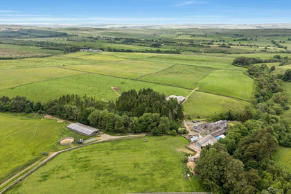
- Price
- Guide Price£1,800,000
- Size
- 291.83 acres
Linacres Farm, Wark, Hexham, Northumberland, NE48, Wark, Northumberland NE48 England
Added on 02/07/2026Farm