
Breadsell Lane, St Leonards-On-Sea, TN38
- Land size
- 102.36 acres
Description
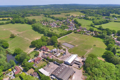
An attractive residential farm in the heart of 1066 country offering an impressive range of accommodation, farm buildings and exceptional equestrian facilities with significant diversification income potential. In all about 102.36 acres.
Grade II Listed 4 bedroom farmhouse with gardens and grounds.
7 Holiday cottages with existing business and proven income.
PP for further 2 bed holiday unit
Superb modern equestrian unit extending to some 13,913 sq. ft, with 20 indoor boxes, indoor exercise arena and service areas.
Extensive range of traditional and modern farm buildings covering over 24,000sq. ft
Permanent pasture, arable and woodland
Park Farm offers a versatile and appealing rural opportunity with multiple enterprises and income generation potential with good communications providing convenient access to London and the south coast whilst enjoying a fine location in the High Weald countryside.
There is an impressive range of accommodation, the principal dwelling being a Grade II listed Regency style 4 bedroom farmhouse with private garaging set in formal gardens with lovely views over the farm and to the sea. In addition, there are eight converted and characterful holiday cottages with excellent earning potential.
One of the standout features of the property is its newly constructed sizeable equestrian facility incorporating 20 indoor stables, service areas and indoor exercise arena. The remaining farm buildings are set around concrete yard areas and provide a functional range of more modern general purpose agricultural barns and traditional buildings including an old dairy and stabling.
The farmland is set in a single block and is a combination of productive permanent pasture managed for grazing and foraging, along with arable and woodland.
The Farmhouse
Park Farmhouse is situated to the north of the central courtyard in an elevated position with its own private gardens overlooking the farm with wonderful views towards the English Channel and South Downs. A Grade II Listed, Regency style 4 bedroom house with period features including bay windows and feature fireplaces, it offers 3,110 sq. ft. of elegantly proportioned accommodation over three floors. On the ground floor there is a kitchen, utility room, WC, sitting room and dining room accessed off a large central entrance hall.
The first floor consists of a master bedroom with an ensuite shower room and dressing room with fitted wardrobes, 3 further bedrooms, all with fitted wardrobes and a family bathroom.
Stairs lead from the first floor landing to three adjoining attic rooms which are currently used as a storage area and give access to the eaves.
The current owners have carried out substantial renovations to the house in recent years including replacement windows, a new tiled roof and internal renovations. Some of these works are subject to ongoing planning applications. Further details are available from the Agent on request.
Outside
Directly behind the farmhouse is a brick-built outbuilding currently used for storage and as a workshop. The farmhouse is approached via a drive off Breadsell Lane, separate to the main farm entrance, leading into a large parking/turning area to the side of the house with an open bay double garage off. Breadsell Lane itself runs southwest to connect to Crowhurst Road and beyond to the primary road network, including the A2690 (Combe Valley Way).
The Gardens and Grounds
The gardens and grounds are a delightful feature extending southwards from the front of the house enjoying far reaching views to the coast. The immediate garden is in need of landscaping following recent works. Beyond this, steps lead down to attractive landscaped grounds with extensive areas of lawn interspersed with mature tree specimens and a large pond enclosed with a combination of attractive brick walling, mature hedges and post and rail fencing.
The Holiday Let Cottages
The current owner has converted a number of the traditional farm buildings, including most recently a Sussex Barn, into eight characterful holiday lets with a total floor area of 6,982sq ft. Seven of the cottages are situated around a central courtyard broadly forming an enclosed quadrangle, with private entrances and courtyard gardens. The owner has operated a successful business for several years demonstrating excellent occupancy levels and it is considered that there is an income potential in the region of £200,000 per annum.
The Farm Buildings
The property is served by a good range of traditional and modern farm buildings set to the south and east of the farmhouse and holiday lets, including an old dairy and general purpose steel-framed agricultural barns set around concrete yards and aprons, with power and lighting throughout; dimensions and layout are shown on the buildings plan contained within these particulars.
Equestrian
An exceptional element of the property is the equestrian diversification enterprise which offers excellent potential for income, notably the recently constructed equestrian unit (approx. 55m x 25m) of steel frame construction, externally faced in brick with horizontal boarding above and profile sheet roofing. Internally, it offers 13,913sq ft of space and comprises 20 Lodden box stables at the eastern end of the building and an indoor riding arena (approx. 23m x 23m) at the western end, separated by a tack room, toilets and welfare areas and office. There are two sliding access doors in each of the gable ends, with a further sliding access door in the side (south) elevation and windows along both sides. Some of the other farm buildings have been internally modified to provide further stabling/facilities.
The land extends to the north and south of the farmhouse and buildings, gently sloping down to the southern boundary with a slight fall westwards to a watercourse and is slightly acid loamy and clayey soils, classified as Grade 3 Agricultural Land and located within the High Weald National Landscape.
The block is subdivided by way of fences, hedges and mature tree screens into fields/enclosures comprising of permanent pasture, for grazing of horses and making of grass forage, arable land and a variety of broadleaf woodland ghylls and shaws. The pasture land extends to about 37 acres and wraps around the farm buildings being immediately accessible from the equestrian area. The 36 acres of arable land is located beyond to the north and west with approximately 22 acres of woodland pockets.
GENERAL INFORMATION
Services
Mains electricity (3-phase), mains water; oil-fired central heating and hot water to farmhouse and holiday lets; private drainage.
Local Authority
Rother District Council. www.rother.gov.uk
Outgoings
Council Tax Band ‘G’.
Business Rates
The holiday cottages are subject to Business Rates. Further details available upon request.
Energy Performance
Park Farmhouse EPC ‘D’.
The Wrens, Little Foxes, Badgers Barn EPC ‘C’.
Honey Suckle Cottage, Primrose Cottage, Clover Cottage and Meadow View EPC ‘E’ Rating.
Planning
There are live planning applications with Rother District Council relating to works to the Farmhouse reference RR/2025/1635/P and RR/2025/1636/L. Further information and a full planning history is available from Samuel & Son upon request.
Boundaries & Acreages
Purchasers must satisfy themselves on the location of all boundaries from the Land Registry Plans available and their own physical inspection of the Property. Any acreages quoted are for guidance purposes only.
Plans & Photographs
The plans provided are for identification and guidance purposes only. External photographs were taken in October 2024, internal photographs in October 2026
Further details can be found on the sales brochure.
The property lies in a peaceful location surrounded by the beautiful countryside of the High Weald National Landscape, about 2.3 miles east of the sought-after village of Crowhurst. The village has a good primary school, popular local pub, a historic parish church, a village hall and a recreation ground along with mainline train station with services to London (Waterloo, Charing Cross, London Bridge).
The coastal towns of Hastings and Bexhill are some 5.5 miles and 6 miles distant respectively, Hastings famed for its vibrant Old Town and both having a good range of entertainment, amenities and attractive seafronts as well as main line stations.
The historic town of Battle with its famous Battle Abbey is 6.5 miles to the north with high street shops and main line station.
There are good road connections with the A21 London Road close by linking to the wider national road network
There is a wide choice of schooling in the general area. - Claverham Community College and Battle Abbey School at Battle; Claremont Preparatory School in St Leonards and Senior School at Bodiam; Marlborough House Vinehall School at Robertsbridge; St Ronan’s at Hawkhurst. to the wider national road network.
Directions
what3words:
///supposed.punchy.celebrate
Map Location
Property details
- Tenure
- Freehold
- Council Tax Band
- G
- Date Posted
- 2026-10-29
Market Value Analysis
Compared with 18 Farms & Smallholdings listings in South East England (100+ acres).
Property Brochure
Seen the details? The full report adds the independent checks: planning activity, flood history, heritage and ground.
Utilities & Restrictions
Utilities
- Electricity
- Ask Agent
- Water
- Ask Agent
- Heating
- Ask Agent
- Broadband
- Ask Agent
- Sewerage
- Ask Agent
Rights & Restrictions
- Public Rights of Way
- Ask Agent
- Private Rights of Way
- Ask Agent
- Listed Property
- Ask Agent
- Restrictions
- Ask Agent
Listed status, conservation areas and planning constraints for this location are in the full report.
Property Features
- Accessibility
- Ask Agent
- Parking
- Ask Agent
- Garden
- Ask Agent
Beyond the particulars: planning activity, flood history, heritage and ground risks, checked for this exact spot.
Connectivity
Broadband
Fastest speed available at this postcode
1.8 Gbps
Gigabit full fibre · available to 71% of premises
Suitable for
- 4K streaming on every screen
- Full-time home working
- Online gaming & big downloads
Mobile signal
Predicted 4G and 5G signal; indoor signal depends on building materials.
Ofcom Connected Nations postcode-level predictions. Speeds and signal are modelled, not measured, and vary between addresses and providers.
Signal is the easy part. Planning activity, flood history and protected designations here are in the full report.
Nearest Schools
Primary
- Churchwood Primary School0.9 milesOfsted: Good
- Ages
- 2 to 11
- Pupils
- 241
- Type
- Academy converter
- Robsack Wood Primary School1.1 milesOfsted: Good
- Ages
- 0 to 11
- Pupils
- 404
- Type
- Academy converter
- Crowhurst CofE Primary School1.1 milesNo Ofsted rating
- Ages
- 5 to 11
- Pupils
- 96
- Type
- Voluntary controlled school
- Faith
- Church of England
- Hollington Primary School1.2 milesOfsted: Inadequate
- Ages
- 2 to 11
- Pupils
- 264
- Type
- Academy converter
- Ark Little Ridge Primary Academy1.4 milesOfsted: Outstanding
- Ages
- 4 to 11
- Pupils
- 435
- Type
- Academy sponsor led
Secondary
- Ark Alexandra Academy2 milesOfsted report card · Jun 2026
- Ages
- 11 to 16
- Pupils
- 1,315
- Type
- Academy sponsor led
- Faith
- Church of England
- Mulberry Academy St Leonards2.1 milesOfsted: Inadequate *
- Ages
- 11 to 16
- Type
- Academy sponsor led
- Claverham Community College3.3 milesNo Ofsted rating
- Ages
- 11 to 16
- Pupils
- 1,147
- Type
- Community school
- St Richard's Catholic College3.3 milesOfsted: Good
- Ages
- 11 to 16
- Pupils
- 1,029
- Type
- Academy converter
- Faith
- Roman Catholic
- Bexhill High Academy3.7 milesOfsted: Good *
- Ages
- 11 to 16
- Pupils
- 1,441
- Type
- Academy converter
* Latest graded judgement covers quality of education only; no overall grade was issued under the 2024-25 inspection framework.
Distances are straight-line from the advertised location. Source: the national school registers (DfE, Welsh Government, Scottish Government) and Ofsted.
Schools are just the start: sold prices nearby, planning activity and any flood history are in the full report.
Amenities
Supermarket
GP surgery
Pharmacy
Hospital
Green space
Straight-line distances from the advertised location. Sources: NHS records, Geolytix supermarket locations, OS Open Greenspace and the national trails registers.
The area stacks up? Now check the location itself: planning nearby, protected designations and past flooding.
Getting Around
Nearest station
Nearest bus stop
Typical drive times
Straight-line distances from the advertised location; drive times are typical free-flow times over OpenStreetMap road data, so allow more at peak. Public transport locations from DfT NaPTAN.
Easy to reach matters. So do planning activity, flood history and ground risks: all in the full report.
Flood Risk
Environment Agency open data, checked around the advertised map pin for the listed acreage. Long-term risk counts flood defences; the planning map's flood zones do not. Provided by LandSale, not the listing agent, and not part of the agent's particulars. Risk varies across a holding, so verify before committing.
Rivers and the sea
Not at the pin: mapped about 190 metres away.
Planning map: Flood Zone 3, about 180 metres away.
Surface water
Not at the pin: mapped about 20 metres away.
These bandings are the summary. Where this location sits on the flood maps, plus planning activity, heritage and ground risks, is in the full report.
Important notice: Information, maps and tags on this page are drawn from the advertising agent's marketing materials or generated automatically. LandSale has not verified them. Relying on these details is at your own risk, always carry out independent checks before committing to a purchase.
LandSale full disclaimer
Marketing information only - not formal particulars. The details on this website are provided for general guidance and do not constitute an offer or contract. Neither LandSale nor the advertising estate/land agent accepts responsibility for any inaccuracy.
1. Source of information
- Listing content: Core description, asking price, tenure, measurements, photographs and planning history originate from the marketing materials of the advertising estate or land agent. LandSale does not author this content and cannot guarantee its accuracy.
- Automated tags & categorisation: Property type, land-use class, acreage bands and similar labels may be applied by machine-learning models. They are intended as a helpful guide only and may not reflect the property's legal status or permitted use.
- Third-party & enriched data layers: Maps, boundary outlines, planning designations, soil reports, broadband coverage and other environmental or location-based insights are licensed from external suppliers. Such data are supplied “as is", may be incomplete or out of date and are subject to change without notice.
2. Verification required
Prospective purchasers must verify critical matters, including but not limited to planning permission, title boundaries, public rights of way, environmental constraints, acreage, services, access and VAT status, through their own inspections, specialist surveys, legal advisers and the selling agent before relying on the information or entering into any contract.
3. No warranty or liability
LandSale gives no warranty, express or implied, as to the accuracy, completeness or fitness for any particular purpose of the information displayed. LandSale shall not be liable for any loss, damage, cost or expense arising directly or indirectly from any use of or reliance on such information, save where liability may not be excluded by law.
4. Updates & feedback
If you believe any detail on this listing is inaccurate, please let us know. We will investigate and, where appropriate, update the listing or notify the agent.
© LandSale | Version 1.3 - August 2026
Contact Samuel and Son Chartered Surveyors, Horam
Bank House, High Street, Horam, TN21 0EH
View agent profileSimilar properties for sale
- Price
- Guide Price£4,000,000
- Size
- 433 acres
Added on 19/03/2026Farm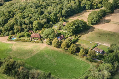
- Price
- Guide Price£4,550,000
- Size
- 51 acres
Hinksden Road, Benenden, Kent, TN17, Benenden, Kent TN17 England
Added on 29/07/2026House with Land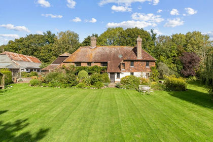
- Price
- £2,900,000
- Size
- 200 acres
Park Lane, Laughton, Lewes, BN8, Laughton, East Sussex BN8 England
Added on 29/01/2026Country Estate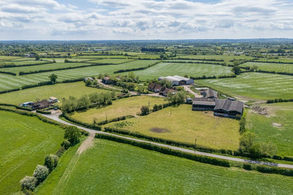
- Price
- Guide Price£4,250,000
- Size
- 211 acres
Lower Farm Road, Boughton Monchelsea, Boughton Monchelsea, Kent ME17 England
Added on 28/05/2026Farm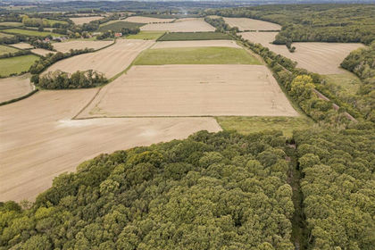
- Price
- Guide Price£3,900,000
- Size
- 274.05 acres
Lower Ensden Road, Old Wives Lees, Canterbury, Chilham, Kent CT4 England
Added on 22/10/2026Farm