Historic Former Rectory in a Private Setting in Thursford
- Land size
- 2 acres
- Bedrooms
- 4
- Bathrooms
- 3
Key Features
- Attractive Gated Grounds of Approximately 2 Acres, Including a 1 Acre Paddock (STMS)
- Spacious, Flexible Accommodation
- Two Reception Rooms
- Large Kitchen and Separate Utility Room
- Four Bedrooms, with Principal En-Suite
- Striking Exterior Original Features
- Grade II Listed
- Semi-Rural Setting
- Close to the Coast and Holt
- Substantial Outbuilding
Description
St. Andrew has been a much loved family home for many years and has now come onto the market. This impressive Grade II Listed former rectory was transformed from a barn into a house in the mid 19th century by the St Andrew’s Church patrons at Thursford Hall. The building includes wonderful 4-light arched casement windows, crow stepped gables, Gothic round chimney stacks and attractive diamond diaper blue brickwork. At one time, the house would have had far reaching field views but now sits in discreet grounds of approximately 2 acres (STMS) surrounded by trees and high hedging, offering a degree of privacy.
The gardens are a particular feature having been well maintained and nurtured over the years. Within the plot is a 1 acre paddock, and there are many mature trees and shrubs throughout the grounds. In addition, there are a number of sheds and small outbuildings as well as a double garage and dovecote building offering a generous footprint for further potential uses (subject to gaining the necessary planning consent).
The house itself has plenty of scope to create a spacious family home. Currently the accommodation consists, in brief, of two reception rooms both with wood-burners, a large well-fitted-out modern kitchen with an Aga, utility room, study and cloakroom. A first floor landing leads to four good size bedrooms (one with dressing area and en-suite) and a large family bathroom.
Important buildings such as St. Andrew rarely come onto the market in this location making this a truly unique opportunity.
THURSFORD
A small rural village tucked between Fakenham and the North Norfolk coast, Thursford is best known as the home of the world-famous Thursford Collection, one of Norfolk’s most celebrated attractions. Renowned for its extraordinary collection of steam engines, mechanical organs and vintage fairground rides, the attraction also hosts the hugely popular Christmas Spectacular, Santa’s Magical Journey and seasonal events that draw visitors from across the country.
Despite its peaceful rural setting, Thursford offers a handful of everyday amenities including St Andrew’s Church, a garage and the well-regarded The Crawfish Inn, a long-established Thai restaurant and pub known locally for its authentic cuisine and welcoming atmosphere.
The nearby market town of Fakenham provides supermarkets, independent shops, a cinema, schools and a traditional Thursday market that continues to serve the town centre, alongside a popular monthly farmers’ market. Fakenham’s rich industrial heritage can still be explored via the Lancaster Heritage Trail, where plaques and historic printing blocks reveal the town’s past as a nationally important centre for printing and agriculture.
Just eight miles away lies the elegant Georgian town of Holt, renowned for its independent boutiques, galleries, cafés and restaurants, as well as the highly regarded Gresham’s School. The stunning North Norfolk coastline is also within easy reach, with destinations such as Wells-next-the-Sea, Holkham and Blakeney offering expansive sandy beaches, salt marshes, coastal walks and sailing opportunities.
Combining countryside tranquillity with excellent access to the coast and market towns, Thursford remains one of North Norfolk’s most distinctive and well-loved villages.
SERVICES CONNECTED
Mains electricity and water. Private drainage. Oil fired central heating.
COUNCIL TAX
Band G.
ENERGY EFFICIENCY RATING
E. Ref:- 6790-8446-0122-3694-3063
To retrieve the Energy Performance Certificate for this property please visit and enter in the reference number above. Alternatively, the full certificate can be obtained through Sowerbys.
TENURE
Freehold.
LOCATION
What3words: ///fallen.spike.dressings
WEBSITE TAGS
village-spirit
bloom-blossom
room-to-roam
family-life
historical-homes
project-homes
EPC Rating: E
Parking - Driveway
Parking - Garage
Disclaimer
These particulars are provided as a guide only and do not form part of any offer or contract. Sowerbys and its representatives have no authority to make or give representations or warranties. All descriptions, measurements, photographs and plans are for guidance only and should not be relied upon as statements of fact. Buyers should satisfy themselves as to the accuracy of the information through inspection or professional advice. Services, appliances and equipment have not been tested and no warranty can be given as to their condition. Planning permissions, building regulations and other consents should be verified by the buyer’s legal adviser. In accordance with Anti-Money Laundering regulations, proceeding buyers must complete a digital ID check through our compliance partner. A charge of £48 including VAT per sale or purchase applies. Leasehold buyers should confirm ground rent, service charges and lease details with their legal adviser.
Map Location
Property details
- Tenure
- Freehold
- Council Tax Band
- G
- Date Posted
- 2026-10-22
Market Value Analysis
Compared with 1,073 Homes with Land listings in East Anglia (1+ acres).
Energy Performance Certificate
Energy Efficiency Rating
Based on UK Energy Performance Certificate standards (EU Directive 2002/91/EC)
Running costs are one side. Planning activity, flood history and ground risks for this location are in the full report.
Utilities & Restrictions
Utilities
- Electricity
- Mains
- Water
- Mains
- Heating
- Oil Heating
- Broadband
- Standard Copper (ADSL)
- Sewerage
- Ask Agent
Rights & Restrictions
- Public Rights of Way
- Ask Agent
- Private Rights of Way
- Ask Agent
- Listed Property
- Yes
- Restrictions
- Ask Agent
Listed status, conservation areas and planning constraints for this location are in the full report.
Property Features
- Accessibility
- Ask Agent
- Parking
- Garage, Driveway
- Garden
- Private Garden
Beyond the particulars: planning activity, flood history, heritage and ground risks, checked for this exact spot.
Connectivity
Broadband
Fastest speed available at this postcode
18 Mbps
Standard (10-30 Mbps)
Suitable for
- Web & social
- Music streaming
- Standard video calls
Mobile signal
Predicted 4G and 5G signal; indoor signal depends on building materials.
Ofcom Connected Nations postcode-level predictions. Speeds and signal are modelled, not measured, and vary between addresses and providers.
Signal is the easy part. Planning activity, flood history and protected designations here are in the full report.
Nearest Schools
Primary
- Hindringham Church of England Primary School1.5 milesNo Ofsted rating
- Ages
- 5 to 11
- Pupils
- 35
- Type
- Voluntary aided school
- Faith
- Church of England
- Little Snoring Community Primary Academy2.3 milesOfsted: Good *
- Ages
- 4 to 11
- Pupils
- 65
- Type
- Academy converter
- All Saints Stibbard Church of England Primary Academy and Nursery3.5 milesOfsted: Requires improvement
- Ages
- 2 to 11
- Pupils
- 208
- Type
- Academy converter
- Faith
- Church of England
- Astley Primary School3.9 milesOfsted: Good
- Ages
- 5 to 11
- Pupils
- 200
- Type
- Academy converter
- Walsingham CE VA Primary School4 milesOfsted: Requires improvement
- Ages
- 4 to 11
- Pupils
- 30
- Type
- Voluntary aided school
- Faith
- Church of England
Secondary
- Fakenham Academy5.1 milesNo Ofsted rating
- Ages
- 11 to 18
- Pupils
- 723
- Type
- Academy sponsor led
- Alderman Peel High School7.2 milesOfsted: Good
- Ages
- 11 to 16
- Pupils
- 606
- Type
- Academy converter
- Reepham High School and College9.8 milesOfsted: Good *
- Ages
- 11 to 18
- Pupils
- 959
- Type
- Academy converter
- Sheringham High School11 milesOfsted: Good
- Ages
- 11 to 18
- Pupils
- 630
- Type
- Academy converter
- Litcham School12 milesOfsted: Good
- Ages
- 4 to 16
- Pupils
- 727
- Type
- Academy converter
* Latest graded judgement covers quality of education only; no overall grade was issued under the 2024-25 inspection framework.
Distances are straight-line from the advertised location. Source: the national school registers (DfE, Welsh Government, Scottish Government) and Ofsted.
Schools are just the start: sold prices nearby, planning activity and any flood history are in the full report.
Amenities
Supermarket
GP surgery
Pharmacy
Hospital
Green space
Straight-line distances from the advertised location. Sources: NHS records, Geolytix supermarket locations, OS Open Greenspace and the national trails registers.
The area stacks up? Now check the location itself: planning nearby, protected designations and past flooding.
Getting Around
Nearest station
Nearest bus stop
Typical drive times
Straight-line distances from the advertised location; drive times are typical free-flow times over OpenStreetMap road data, so allow more at peak. Public transport locations from DfT NaPTAN.
Easy to reach matters. So do planning activity, flood history and ground risks: all in the full report.
Flood Risk
Environment Agency open data, checked around the advertised map pin for the listed acreage. Long-term risk counts flood defences; the planning map's flood zones do not. Provided by LandSale, not the listing agent, and not part of the agent's particulars. Risk varies across a holding, so verify before committing.
Rivers and the sea
Planning map: Flood Zone 1.
Surface water
Not at the pin: mapped about 40 metres away.
These bandings are the summary. Where this location sits on the flood maps, plus planning activity, heritage and ground risks, is in the full report.
Important notice: Information, maps and tags on this page are drawn from the advertising agent's marketing materials or generated automatically. LandSale has not verified them. Relying on these details is at your own risk, always carry out independent checks before committing to a purchase.
LandSale full disclaimer
Marketing information only - not formal particulars. The details on this website are provided for general guidance and do not constitute an offer or contract. Neither LandSale nor the advertising estate/land agent accepts responsibility for any inaccuracy.
1. Source of information
- Listing content: Core description, asking price, tenure, measurements, photographs and planning history originate from the marketing materials of the advertising estate or land agent. LandSale does not author this content and cannot guarantee its accuracy.
- Automated tags & categorisation: Property type, land-use class, acreage bands and similar labels may be applied by machine-learning models. They are intended as a helpful guide only and may not reflect the property's legal status or permitted use.
- Third-party & enriched data layers: Maps, boundary outlines, planning designations, soil reports, broadband coverage and other environmental or location-based insights are licensed from external suppliers. Such data are supplied “as is", may be incomplete or out of date and are subject to change without notice.
2. Verification required
Prospective purchasers must verify critical matters, including but not limited to planning permission, title boundaries, public rights of way, environmental constraints, acreage, services, access and VAT status, through their own inspections, specialist surveys, legal advisers and the selling agent before relying on the information or entering into any contract.
3. No warranty or liability
LandSale gives no warranty, express or implied, as to the accuracy, completeness or fitness for any particular purpose of the information displayed. LandSale shall not be liable for any loss, damage, cost or expense arising directly or indirectly from any use of or reliance on such information, save where liability may not be excluded by law.
4. Updates & feedback
If you believe any detail on this listing is inaccurate, please let us know. We will investigate and, where appropriate, update the listing or notify the agent.
© LandSale | Version 1.3 - August 2026
Similar properties for sale
- Price
- Guide Price£1,000,000
- Size
- 1.25 acres
Fakenham Road, Stibbard, Fakenham, Norfolk, NR21, Stibbard, Norfolk NR21 England
Added on 12/08/2026House with Land
- Price
- Guide Price£750,000
- Size
- 1 acres
Dereham Road, Colkirk, Fakenham, Norfolk, NR21, Colkirk, Norfolk NR21 England
Added on 11/04/2026House with Land
- Price
- Guide Price£1,000,000
- Size
- 1.95 acres
Added on 16/06/2026House with Land
- Price
- Offers in Excess of£700,000
- Size
- 1.5 acres
Great Heath Road, North Elmham, North Elmham, Norfolk NR20 England
Added on 16/06/2026Development Land
- Price
- Guide Price£895,000
- Size
- 1 acres
A Characterful Country Home in Hempstead, Hempstead, Norfolk NR25 England
Added on 23/07/2026Barn Conversion
- Price
- Guide Price£730,000
- Size
- 3.25 acres
Detached Bungalow in Corpusty with 3.25 Acres (stms), Corpusty and Saxthorpe, Norfolk NR11 England
Added on 12/10/2026House with Land
- Price
- Guide Price£1,000,000
- Size
- 1.25 acres
Added on 29/01/2026Barn Conversion
- Price
- £795,000
- Size
- 1 acres
Church Lane, Swannington, NR9, Swannington, Norfolk NR9 England
Added on 07/10/2026House with Land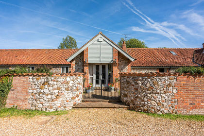
- Price
- £750,000
- Size
- 1.3 acres
Added on 14/10/2026Barn Conversion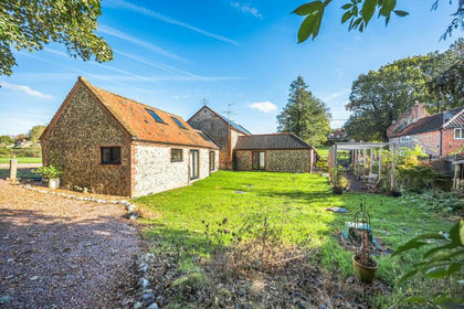
- Price
- Guide Price£775,000
- Size
- 2 acres
Characterful Barn Conversion in Felbrigg, Felbrigg, Norfolk NR11 England
Added on 04/11/2026Barn Conversion