Greenfields Lane, Market Drayton
- Land size
- 0.15 acres
Key Features
- Building Plot with Lapsed Planning Permission for a Four Bedroom Detached House with Garage
- Original Planning Permission 21/05292/FUL
- Four Bedroom House approx. 132 sq.m - and 153 sq.m including the Garage
- Plot is Approx. 0.15 acres and this will be confirmed during contract stage.
- Mains water, drainage and electricity available for connection
- Great Location close to Town Centre, Easy access to the A53
- Access is from Greenfields Lane.
- Ideal for a Self-Build or Developer
Description
BUILDING PLOT DETAILS A rare opportunity to purchase a Building Plot with Lapsed Planning Permission 21/05292/FUL for a Detached Four Bedroom House with Detached Garage. The plot is approximately 0.15 acres, and this will be confirmed during the contract period.
The land is along Greenfields Lane, just after the rugby club on your left - and access will be from Greenfields Lane and not from the driveway which will be retained by the vendor. It has great road access to the A529 and A53 for Shrewsbury, Newcastle-under-Lyme, Audlem, Loggerheads and the surrounding villages. Please contact our Market Drayton Office to arrange a viewing.
LOCATION Market Drayton is a historic market town, well known for its weekly street market held every Wednesday, with a market charter dating back to 1245. Offering an excellent range of everyday amenities, the town is home to The Grove School with Sixth Form, an indoor swimming pool, doctors' surgeries, dentists, supermarkets, independent shops, cafés and a variety of sports and leisure clubs. The picturesque Shropshire Union Canal also passes through the town, providing attractive waterside walks and recreational opportunities.
Ideally positioned for commuting, Market Drayton enjoys excellent road connections via the A53 to Shrewsbury and Newcastle-under-Lyme, while the A41 provides access to Newport and Whitchurch.
DIRECTIONS From our office on Maer Lane, turn left, right at Nagington's Garage, head out of town over the bridge and turn left on Greenfields Lane. Go passed the Rugby Club and then the plot is on the corner of the next left hand driveway and can be identified by our For Sale sign.
IMPORTANT INFORMATION TO VIEW THIS PROPERTY: By arrangement with the Agents Office at Tower House, Maer Lane, Market Drayton, TF9 3SH. T el: or email:
SERVICES: There is a mains water service in Greenfields Lane on the side adjacent to the plot. Mains electricity and drainage are also available for connection. Access to the plot will be from Greenfields Lane as the Driveway will be retained by the vendors. Therefore, the plot is approximately 0.15 acres, but the actual plot area will be defined at contract stage,
There is a redundant septic tank in the plot, previously serving Meadowside, it is covered but please take care when viewing.
TENURE: We are advised that the property is Freehold and this will be confirmed by the Vendors Solicitor during the Pre- Contract Enquiries. Vacant possession upon completion.
METHOD OF SALE: For Sale by Private Treaty.
FLOOR/SITE PLANS: This floor plan is not to scale - please use it as a guideline to suggested layout only. The site plan and drawings relate to the lapsed planning position so the buyer may need to review as part of the reapplication process.
AML REGULATIONS: We are required by law to conduct Anti-Money Laundering checks on all those buying a property. The initial checks are carried out on our behalf by MoveButler who will contact you once you have had an offer accepted on a property. The cost of these checks is £30 (incl. VAT) per buyer, which covers the cost of obtaining relevant data and any manual checks and monitoring which might be required. This fee will need to be paid by you, directly to MoveButler, ahead of us issuing a memorandum of sale, and is non-refundable.
BARBERS COPYRIGHT: Unless we agree otherwise with you in writing, we hold the copyright on all photographic and video marketing material used to market this property. These should not be reproduced by any third party without our express consent. Furthermore, we reserve the right to use these for marketing initiatives to promote the property or the Company. We may use various options for marketing including all social media and mailing campaigns, all designed to help with the sale/rental of your property.
PHOTOGRAPHS: Photos may have been enhanced for colour and clarity using AI.
PROPERTY INFORMATION: We believe this information to be accurate, but it cannot be guaranteed. The fixtures, fittings, appliances and mains services have not been tested. If there is any point which is of particular importance, please obtain professional confirmation. All measurements quoted are approximate. These particulars do not constitute a contract or part of a contract.
PROPERTY VALUATION SERVICE: If you're looking to sell your property, our highly experienced Valuers can give you a No Obligation, Free-of-Charge Sales Valuation on your property. During this appointment we will discuss sold prices of similar properties, comparable properties currently on the market and the property market conditions - helping us to make a marketing plan to suit your needs. Call us on to arrange an appointment.
MD
Map Location
Property details
- Tenure
- Freehold
- Council Tax Band
- Ask Agent
- Date Posted
- 2026-10-09
Utilities & Restrictions
Utilities
- Electricity
- Ask Agent
- Water
- Ask Agent
- Heating
- Ask Agent
- Broadband
- Ask Agent
- Sewerage
- Ask Agent
Rights & Restrictions
- Public Rights of Way
- Ask Agent
- Private Rights of Way
- Ask Agent
- Listed Property
- Ask Agent
- Restrictions
- Ask Agent
Listed status, conservation areas and planning constraints for this location are in the full report.
Property Features
- Accessibility
- Ask Agent
- Parking
- Parking Available
- Garden
- Ask Agent
Beyond the particulars: planning activity, flood history, heritage and ground risks, checked for this exact spot.
Connectivity
Broadband
Fastest speed available at this postcode
80 Mbps
Superfast
Suitable for
- HD streaming
- Video calls
- Web & social
Fixed wireless access may also be an option here.
Mobile signal
Predicted 4G and 5G signal; indoor signal depends on building materials.
Ofcom Connected Nations postcode-level predictions. Speeds and signal are modelled, not measured, and vary between addresses and providers.
Signal is the easy part. Planning activity, flood history and protected designations here are in the full report.
Nearest Schools
Primary
- Market Drayton Infant & Nursery School747 metresNo Ofsted rating
- Ages
- 2 to 7
- Pupils
- 346
- Type
- Academy converter
- Market Drayton Junior School790 metresNo Ofsted rating
- Ages
- 7 to 11
- Pupils
- 333
- Type
- Academy converter
- Longlands Primary School0.7 milesOfsted: Good
- Ages
- 2 to 11
- Pupils
- 201
- Type
- Academy sponsor led
- Buntingsdale Primary School and Nursery2 milesNo Ofsted rating
- Ages
- 3 to 11
- Pupils
- 76
- Type
- Community school
- Moreton Say CofE Primary School2.3 milesOfsted: Good
- Ages
- 2 to 11
- Pupils
- 111
- Type
- Voluntary controlled school
- Faith
- Church of England
Secondary
- The Grove School0.8 milesOfsted: Requires improvement
- Ages
- 11 to 18
- Pupils
- 856
- Type
- Academy converter
- Sir John Talbot's School8.2 milesOfsted: Good
- Ages
- 11 to 19
- Pupils
- 861
- Type
- Academy sponsor led
- Madeley High School9.2 milesNo Ofsted rating
- Ages
- 11 to 16
- Pupils
- 779
- Type
- Academy converter
- Brine Leas School10 milesNo Ofsted rating
- Ages
- 11 to 18
- Pupils
- 1,417
- Type
- Academy converter
- The Thomas Adams School10 milesOfsted: Good
- Ages
- 11 to 18
- Pupils
- 1,214
- Type
- Academy converter
Distances are straight-line from the advertised location. Source: the national school registers (DfE, Welsh Government, Scottish Government) and Ofsted.
Schools are just the start: sold prices nearby, planning activity and any flood history are in the full report.
Amenities
Supermarket
GP surgery
Pharmacy
Hospital
Green space
Straight-line distances from the advertised location. Sources: NHS records, Geolytix supermarket locations, OS Open Greenspace and the national trails registers.
The area stacks up? Now check the location itself: planning nearby, protected designations and past flooding.
Getting Around
Nearest station
Nearest bus stop
Typical drive times
Straight-line distances from the advertised location; drive times are typical free-flow times over OpenStreetMap road data, so allow more at peak. Public transport locations from DfT NaPTAN.
Easy to reach matters. So do planning activity, flood history and ground risks: all in the full report.
Flood Risk
Environment Agency open data, checked around the advertised map pin for the listed acreage. Long-term risk counts flood defences; the planning map's flood zones do not. Provided by LandSale, not the listing agent, and not part of the agent's particulars. Risk varies across a holding, so verify before committing.
Rivers and the sea
Planning map: Flood Zone 1.
Surface water
Not at the pin: mapped about 20 metres away.
These bandings are the summary. Where this location sits on the flood maps, plus planning activity, heritage and ground risks, is in the full report.
Important notice: Information, maps and tags on this page are drawn from the advertising agent's marketing materials or generated automatically. LandSale has not verified them. Relying on these details is at your own risk, always carry out independent checks before committing to a purchase.
LandSale full disclaimer
Marketing information only - not formal particulars. The details on this website are provided for general guidance and do not constitute an offer or contract. Neither LandSale nor the advertising estate/land agent accepts responsibility for any inaccuracy.
1. Source of information
- Listing content: Core description, asking price, tenure, measurements, photographs and planning history originate from the marketing materials of the advertising estate or land agent. LandSale does not author this content and cannot guarantee its accuracy.
- Automated tags & categorisation: Property type, land-use class, acreage bands and similar labels may be applied by machine-learning models. They are intended as a helpful guide only and may not reflect the property's legal status or permitted use.
- Third-party & enriched data layers: Maps, boundary outlines, planning designations, soil reports, broadband coverage and other environmental or location-based insights are licensed from external suppliers. Such data are supplied “as is", may be incomplete or out of date and are subject to change without notice.
2. Verification required
Prospective purchasers must verify critical matters, including but not limited to planning permission, title boundaries, public rights of way, environmental constraints, acreage, services, access and VAT status, through their own inspections, specialist surveys, legal advisers and the selling agent before relying on the information or entering into any contract.
3. No warranty or liability
LandSale gives no warranty, express or implied, as to the accuracy, completeness or fitness for any particular purpose of the information displayed. LandSale shall not be liable for any loss, damage, cost or expense arising directly or indirectly from any use of or reliance on such information, save where liability may not be excluded by law.
4. Updates & feedback
If you believe any detail on this listing is inaccurate, please let us know. We will investigate and, where appropriate, update the listing or notify the agent.
© LandSale | Version 1.3 - August 2026
Listing agent
Barbers, Market Drayton
Tower House, Maer Lane, Market Drayton, TF9 3SH
Similar properties for sale
- Price
- Offers in Region of£155,000
Heathwood Road, Higher Heath, Prees, Shropshire SY13 England
Added on 01/05/2026Building Plot
- Price
- Offers in Region of£120,000
Building Plot on Kingsway, Whitchurch, Whitchurch Urban, Shropshire SY13 England
Added on 18/06/2026Building Plot
- Price
- £150,000
Barn 1 Brockton Hall, Brockton, Eccleshall, Stafford, Eccleshall, Staffordshire ST21 England
Added on 22/08/2026Development Land
- Price
- Guide Price£140,000
Plot 1. Keele Road, Madeley Heath, Newcastle-under-Lyme, Madeley, Staffordshire CW3 England
Added on 22/09/2026Development Land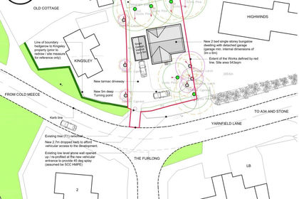
- Price
- Guide Price£150,000
Yarnfield Lane, Yarnfield, ST15, Yarnfield and Cold Meece, Staffordshire ST15 England
Added on 01/10/2026Building Plot
- Price
- Guide Price£180,000
Added on 24/09/2026Development Land
- Price
- Guide Price£180,000
- Size
- 12 acres
Northwood, Ellesmere., Welshampton and Lyneal, Shropshire SY12 England
Added on 24/09/2026Equestrian property
- Price
- £150,000
- Size
- 0.15 acres
Ratton Street, Stoke-On-Trent, ST1, Stoke-on-Trent Central, Stoke-on-Trent ST1 England
Added on 28/08/2026Development Land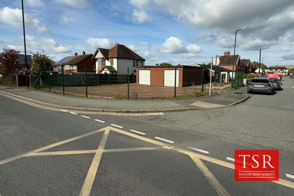
- Price
- Offers in Region of£150,000
- Size
- 0.08 acres
Land at Heathgates, Shrewsbury, SY1, Shrewsbury, Shropshire SY1 England
Added on 31/03/2026Development Land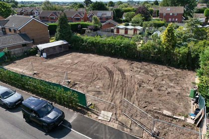 Added on 21/08/2026Self Build Plot