Gossett Lane, Brandon, Coventry
- Land size
- 33.83 acres
Key Features
- Detached five-bedroom farmhouse with two semi-detached cottages
- Approximately 30 loose boxes in a range of traditional and modern buildings
- Floodlit manege with rubber-chipping surface
- Two pasture fields with strong equestrian appeal
- Access to an extensive local bridleway network, with approximately eight miles of routes nearby
- Buildings with potential for alternative commercial or residential uses, subject to planning permission
- Approximately 33.83 acres (13.69 hectares) in all
Description
A substantial equestrian property comprising a five-bedroom farmhouse, two cottages, an extensive range of stabling and buildings, a floodlit manege and pastureland, extending in all to approximately 33.83 acres (13.69 hectares).
Merton Hall Farm offers a rare combination of residential accommodation, established equestrian infrastructure and land in a highly access Warwickshire location.
Description - Howkins & Harrison are pleased to bring to market Merton Hall Farm, an impressive and versatile equestrian holding positioned on the edge of Brandon, to the east of Coventry.
The property extends to approximately 33.83 acres (13.69 hectares) and provides a substantial five-bedroom farmhouse, two semi-detached cottages, an established stable yard with around 30 loose boxes, a range of traditional and steel portal-framed buildings, a floodlit manege and two pasture fields.
Formerly operated as a dairy farm, the holding has been adapted over time to provide a comprehensive equestrian set-up. The combination of residential accommodation, buildings and land gives the property broad appeal to private equestrian purchasers, commercial operators and buyers seeking a lifestyle property with additional income or diversification potential.
The property is particularly well placed for equestrian use, with access to an extensive network of nearby bridleways. Its location, scale and range of buildings create a rarely available opportunity within convenient reach of Coventry, Rugby and the wider Midlands road network.
Location - Merton Hall Farm is situated on Gossett Lane, on the edge of Brandon and approximately 4.9 miles east of Coventry. The property occupies a rural position while remaining conveniently placed for access to surrounding towns, major transport routes and local services.
Coventry railway station is approximately 6 miles by road and offers direct services to Birmingham International and London Euston. Junction 1 of the M6 is approximately 3.1 miles to the north, providing access towards Rugby and the M1. Birmingham Airport lies approximately 15 miles to the west.
The location is especially attractive to equestrian purchasers, with approximately eight miles of bridleways in close proximity to the property, providing excellent opportunities for hacking and recreational riding.
Further details of the approximate bridleway routes are detailed by the orange and yellow dotted lines on the location plan adjacent.
The Property - The residential element comprises Merton Hall Farmhouse together with two semi-detached cottages. The farmhouse provides five-bedroom accommodation and forms the principal residence within the holding. The accommodation in the cottages comprises two bedrooms, a single bathroom with kitchen and living room. The cottages provide useful ancillary accommodation and may appeal to purchasers seeking multi-generational living, staff accommodation or an investment element alongside the main house and equestrian facilities.
The Buildings - The holding includes a broad range of traditional brick and block buildings together with more modern steel portal-framed structures. The buildings have been adapted from the property’s former dairy use and now accommodate the stable yard and associated equestrian facilities. The scale, construction and configuration of the buildings provide considerable flexibility.
In addition to their continued equestrian use, the buildings may be suitable for a range of alternative commercial or residential uses, including conversion or redevelopment, subject to obtaining the necessary planning permission and any other required consents.
The Land - The property extends in all to approximately 33.83 acres (13.69 hectares), including the residential dwellings, buildings, yard, manege and two pasture fields.
The land forms an important part of the overall equestrian package and, together with the nearby bridleway network, provides an attractive setting for owners seeking space for horses within a strategically well-connected location.
Equestrian Features - Merton Hall Farm has been developed as an established equestrian property and provides a comprehensive range of facilities suitable for private use or a professional equestrian operation.
•Around 30 separate loose boxes arranged across the yard and buildings.
•Floodlit manege with a rubber-chipping surface and timber post-and-rail enclosure.
•Two pasture fields suitable for grazing and paddock division.
•Extensive hard standing and yard areas serving the equestrian buildings.
•Immediate access to a strong local bridleway network, enhancing the property for hacking and leisure riding.
•Buildings offering flexibility for stabling, feed, tack, machinery and ancillary storage.
Overage - he land will be sold subject to an overage provision of 30% for a period of 30 years in respect of any uplift in value arising from the future development or a change to a non-agricultural or non-equestrian use. For the avoidance of doubt, the overage will apply to the land only and will expressly exclude the houses, buildings and yard area.
Services - is understood that the property benefits from mains water and electricity. Heating is provided by oil-fired central heating systems. Private drainage and wastewater arrangements serve the property. Services and installations have not been tested and purchasers should satisfy themselves as to their condition and capacity.
Planning And Local Authority - The property lies within the administrative area of Rugby Borough Council. It is situated within the Rugby Green Belt and is not located within a conservation area.
The existing buildings may also offer scope for conversion, redevelopment or diversification to alternative commercial or residential uses, subject to planning permission and all other necessary consents. Purchasers should make their own enquiries with Rugby Borough Council in respect of any proposed future use or development.
Tenure And Possession - The property is freehold and is registered under title numbers WK518972 and WK306069. Vacant possession will be given upon completion. A notice to quit has been served to the current tenant that resides in one of the cottages. If an interested party would like to discuss retaining the tenant please speak with the selling agent.
Council Tax And Business Rates - erton Hall Farm is understood to be assessed within Council Tax Band F. The two cottages are each understood to be assessed within Council Tax Band B. The livery stables and premises are separately assessed for business rates, with a Rateable Value of £12,000 on the 2026 Rating list.
Rights Of Way, Easements And Access - Access is taken from Gossett Lane. The property will be sold subject to and with the benefit of all existing rights of way, easements, wayleaves and other rights, whether or not specifically referred to in these particulars.
Plans And Boundaries - Any plans provided are for identification purposes only. Boundaries, acreages and ownership details should be independently vertified by the purchaser and their professional advisors.
Method Of Sale - Merton Hall Farm is offered for sale by private treaty as a whole.
Viewing - Viewings strictly by appointment only through the selling agent Howkins & Harrison
Howkins & Harrison LLP
Telephone: 01788-564680
Email:
Important Notice - These particulars have been prepared in good faith to give a fair overall view of the property. They do not form part of any offer or contract and should not be relied upon as statements or representations of fact. Any areas, measurements and distances are approximate and are provided as a guide only. Purchasers must satisfy themselves by inspection and through their own professional advisers as to the condition of the property, services, boundaries, planning matters, rights, title and all other matters of importance to them.
No tests have been carried out on any services, installations, appliances or equipment. Photographs, plans and descriptions are for identification and marketing purposes only and may not show the whole of the property. Any reference to potential alternative use, conversion or development is expressly subject to obtaining all necessary planning and other consents.
Map Location
Property details
- Tenure
- Freehold
- Council Tax Band
- F
- Date Posted
- 2026-10-08
Market Value Analysis
Compared with 7 Equestrian listings in West Midlands (25+ acres).
Utilities & Restrictions
Utilities
- Electricity
- Ask Agent
- Water
- Ask Agent
- Heating
- Ask Agent
- Broadband
- Ask Agent
- Sewerage
- Ask Agent
Rights & Restrictions
- Public Rights of Way
- Ask Agent
- Private Rights of Way
- Ask Agent
- Listed Property
- Ask Agent
- Restrictions
- Ask Agent
Listed status, conservation areas and planning constraints for this location are in the full report.
Property Features
- Accessibility
- Ask Agent
- Parking
- Ask Agent
- Garden
- Garden
Beyond the particulars: planning activity, flood history, heritage and ground risks, checked for this exact spot.
Connectivity
Broadband
Fastest speed available at this postcode
5.5 Gbps
Gigabit full fibre · available to 33% of premises
Suitable for
- 4K streaming on every screen
- Full-time home working
- Online gaming & big downloads
Mobile signal
Predicted 4G and 5G signal; indoor signal depends on building materials.
Ofcom Connected Nations postcode-level predictions. Speeds and signal are modelled, not measured, and vary between addresses and providers.
Signal is the easy part. Planning activity, flood history and protected designations here are in the full report.
Nearest Schools
Primary
- Binley Woods Primary School664 metresOfsted: Good
- Ages
- 4 to 11
- Pupils
- 182
- Type
- Community school
- Wolston St Margaret's CofE Primary School1.2 milesOfsted: Good
- Ages
- 4 to 11
- Pupils
- 207
- Type
- Voluntary controlled school
- Faith
- Church of England
- Clifford Bridge Academy1.9 milesOfsted: Good
- Ages
- 3 to 11
- Pupils
- 430
- Type
- Academy converter
- St Bartholomew's Church of England Academy2 milesOfsted report card · Feb 2026
- Ages
- 3 to 11
- Pupils
- 207
- Type
- Academy sponsor led
- Faith
- Church of England
- Ernesford Grange Primary School2.1 milesNo Ofsted rating
- Ages
- 2 to 11
- Pupils
- 451
- Type
- Community school
Secondary
- Ernesford Grange Community Academy2.4 milesNo Ofsted rating
- Ages
- 11 to 18
- Pupils
- 1,187
- Type
- Academy sponsor led
- Caludon Castle School2.5 milesNo Ofsted rating
- Ages
- 11 to 18
- Pupils
- 1,520
- Type
- Academy converter
- Seva School3 milesOfsted: Good
- Ages
- 4 to 16
- Pupils
- 736
- Type
- Free schools
- Faith
- Sikh
- Stoke Park School3.3 milesOfsted report card · May 2026
- Ages
- 11 to 18
- Pupils
- 1,101
- Type
- Academy sponsor led
- Lyng Hall School3.5 milesOfsted: Requires improvement *
- Ages
- 11 to 18
- Pupils
- 1,014
- Type
- Academy converter
* Latest graded judgement covers quality of education only; no overall grade was issued under the 2024-25 inspection framework.
Distances are straight-line from the advertised location. Source: the national school registers (DfE, Welsh Government, Scottish Government) and Ofsted.
Schools are just the start: sold prices nearby, planning activity and any flood history are in the full report.
Amenities
Supermarket
GP surgery
Pharmacy
Hospital
Green space
Straight-line distances from the advertised location. Sources: NHS records, Geolytix supermarket locations, OS Open Greenspace and the national trails registers.
The area stacks up? Now check the location itself: planning nearby, protected designations and past flooding.
Getting Around
Nearest station
Nearest bus stop
Typical drive times
Straight-line distances from the advertised location; drive times are typical free-flow times over OpenStreetMap road data, so allow more at peak. Public transport locations from DfT NaPTAN.
Easy to reach matters. So do planning activity, flood history and ground risks: all in the full report.
Flood Risk
Environment Agency open data, checked around the advertised map pin for the listed acreage. Long-term risk counts flood defences; the planning map's flood zones do not. Provided by LandSale, not the listing agent, and not part of the agent's particulars. Risk varies across a holding, so verify before committing.
Rivers and the sea
Planning map: Flood Zone 1.
Surface water
Not at the pin: mapped about 10 metres away.
These bandings are the summary. Where this location sits on the flood maps, plus planning activity, heritage and ground risks, is in the full report.
Important notice: Information, maps and tags on this page are drawn from the advertising agent's marketing materials or generated automatically. LandSale has not verified them. Relying on these details is at your own risk, always carry out independent checks before committing to a purchase.
LandSale full disclaimer
Marketing information only - not formal particulars. The details on this website are provided for general guidance and do not constitute an offer or contract. Neither LandSale nor the advertising estate/land agent accepts responsibility for any inaccuracy.
1. Source of information
- Listing content: Core description, asking price, tenure, measurements, photographs and planning history originate from the marketing materials of the advertising estate or land agent. LandSale does not author this content and cannot guarantee its accuracy.
- Automated tags & categorisation: Property type, land-use class, acreage bands and similar labels may be applied by machine-learning models. They are intended as a helpful guide only and may not reflect the property's legal status or permitted use.
- Third-party & enriched data layers: Maps, boundary outlines, planning designations, soil reports, broadband coverage and other environmental or location-based insights are licensed from external suppliers. Such data are supplied “as is", may be incomplete or out of date and are subject to change without notice.
2. Verification required
Prospective purchasers must verify critical matters, including but not limited to planning permission, title boundaries, public rights of way, environmental constraints, acreage, services, access and VAT status, through their own inspections, specialist surveys, legal advisers and the selling agent before relying on the information or entering into any contract.
3. No warranty or liability
LandSale gives no warranty, express or implied, as to the accuracy, completeness or fitness for any particular purpose of the information displayed. LandSale shall not be liable for any loss, damage, cost or expense arising directly or indirectly from any use of or reliance on such information, save where liability may not be excluded by law.
4. Updates & feedback
If you believe any detail on this listing is inaccurate, please let us know. We will investigate and, where appropriate, update the listing or notify the agent.
© LandSale | Version 1.3 - August 2026
Listing agent
Howkins & Harrison LLP, Rugby
7-11 Albert Street, Rugby, CV21 2RX
Similar properties for sale
- Price
- Offers in Excess of£1,850,000
- Size
- 20 acres
Princethorpe, Rugby, Stretton-on-Dunsmore, Warwickshire CV23 England
Added on 23/05/2026House with Land
- Price
- Guide Price£2,400,000
- Size
- 152.37 acres
Braunston, Daventry, NN11, Braunston, West Northamptonshire NN11 England
Added on 08/10/2026Farm
- Price
- Offers in Region of£1,700,000
- Size
- 16.5 acres
London Road, Norton, Daventry, NN11, Daventry, West Northamptonshire NN11 England
Added on 01/10/2026Farmhouse
- Price
- Offers Over£2,000,000
- Size
- 20 acres
Broadfields House, Croxall, Lichfield, Edingale, Staffordshire WS13 England
Added on 06/05/2026Country Home
- Price
- Guide Price£2,250,000
- Size
- 40 acres
Hook Norton, Oxfordshire, Hook Norton, Oxfordshire OX15 England
Added on 22/06/2026House with Land
- Price
- Guide Price£1,500,000
- Size
- 16 acres
London Road, Moreton-In-Marsh, Chastleton, Oxfordshire GL56 England
Added on 09/06/2026Farmhouse
- Price
- Guide Price£1,950,000
- Size
- 19.58 acres
Newton Solney, Derbyshire, Newton Solney, Derbyshire DE15 England
Added on 30/07/2026House with Land
- Price
- £1,700,000
- Size
- 21 acres
Leckhampstead, Buckingham, Buckinghamshire, MK18, Leckhampstead, Buckinghamshire MK18 England
Added on 15/08/2026Equestrian property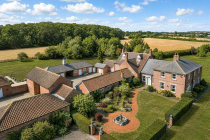
- Price
- Offers Over£2,500,000
- Size
- 23.5 acres
Thorpe-in-the-Glebe, Wysall, Nottingham, Thorpe in the Glebe, Nottinghamshire NG12 England
Added on 13/08/2026Country Estate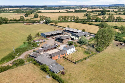
- Price
- Offers in Excess of£1,600,000
- Size
- 76 acres
Added on 11/08/2026Farm