LAND FOR SALE | Woodhouse Farm, Catherine De Barnes Lane, Catherine De Barnes, Solihull
- Land size
- 5.38 acres
- Bedrooms
- 3
Key Features
- Approx 5.38 acres overall including the driveway
- Cherished 3 bedroom detached farmhouse within the grounds – approx. 2864 sq ft
- 7 detached agricultural barns totalling to approx. 25,000 sq ft
- 1 barn currently provides an excellent investment income
- Country field views
- Offered for sale with No Upward Chain
- 1.4 miles to Catherine De Barnes Village offering local amenities
- 2.1 miles to Birmingham Airport and Birmingham International Train Station with frequent routes to Birmingham City Centre and London Euston
- Access to M42 and all major road networks
- VIEWINGS BY APPOINTMENT ONLY
Description
A rare opportunity to purchase a cherished farmhouse and seven agricultural barns within approx. 5.38 acres, discreetly situated with an extensive courtyard accessed via a country road from Catherine De Barnes Lane.
Wood House Farmhouse is included within the sale, offering 2864 sq ft of accommodation with open field views to the rear elevation.
The detached seven agricultural barns available present the opportunity to potentially be developed into residential dwellings, (subject to the appropriate planning permissions). The combined total square footage of the seven detached barns total to 25,000 sq ft.
Please note one of the seven barn is currently rented out as an office space and provides an excellent investment income. Please contact Shepherd Cullen for further information on the annual rental income.
Disclaimer: The mage with the red line boundary used within these details are for visual representation and guidance only.
Access
Access is taken off Catherine De Barnes Lane. Passing the entrance to Birmingham Dogs Home on your left-hand side, continue up the country lane for circa one mile. Wood House Farm is privately situated at the top of the country lane with an extensive courtyard.
What three words: ///keys.metro.junior
Viewing
Viewings available by appointment only via Shepherd Cullen. Please email or phone to arrange an appointment.
Health And Safety
We would like to bring to your attention that the land is uneven in parts and request that you take considerable care for your own personal safety during your visit. We advise sensible footwear to be worn.
Method Of Sale
Land to be sold via Private Treaty. The vendor reserves the right to ask for Best and Final Offers should several offers be received.
Location
This wonderful opportunity is placed near to excellent road, rail and air transport connections, whereby Birmingham Airport and Birmingham International are just 2.1 miles away with frequent services to London Euston, Birmingham and further UK destinations. The M42 is also within a short distance of the property, providing access to all major road networks.
Catherine De Barnes village, offering a great pub, independent restaurant ‘Fox’, village store and village hall are just 1.4 miles and Hampton in Arden, also offering an array of local amenities is just 2.4 miles away. For further amenities and entertainment complext, Solihull Town Centre is 3.3 miles away.
Agents' Note
We have not tested any of the electrical, central heating or sanitaryware appliances. Purchasers should make their own investigations as to the workings of the relevant items. Floor plans are for identification purposes only and not to scale. All room measurements and mileages quoted in these sales particulars are approximate. Subjective comments in these details imply the opinion of the selling agent at the time these details were prepared. Naturally, the opinions of purchasers may differ. These sales particulars are produced to offer a guide only and do not constitute any part of a contract or offer. We would advise that fixtures and fittings included within the sale are confirmed by the purchaser at the point of offer.
Anti Money Laundering (AML)
We are subject to the Money Laundering, Terrorist Financing and Transfer of Funds (Information on the Payer) Regulations 2017. As a result we will need to carry out due diligence on all of our purchasers to confirm their identity. We will therefore obtain and hold evidence confirming your identity and proof of your address. Your identity may be subject to an electronic identity check. This system allows us to verify you from basic details and you understand we will be unable to proceed with any work on your behalf until we obtain this from you in order to meet compliance obligations for Anti Money Laundering.
Map Location
Property details
- Tenure
- Freehold
- Council Tax Band
- Ask Agent
- Date Posted
- 2026-10-02
Market Value Analysis
Compared with 280 Homes with Land listings in West Midlands (5+ acres).
Utilities & Restrictions
Utilities
- Electricity
- Ask Agent
- Water
- Ask Agent
- Heating
- Ask Agent
- Broadband
- Ask Agent
- Sewerage
- Ask Agent
Rights & Restrictions
- Public Rights of Way
- Ask Agent
- Private Rights of Way
- Ask Agent
- Listed Property
- Ask Agent
- Restrictions
- Ask Agent
Listed status, conservation areas and planning constraints for this location are in the full report.
Property Features
- Accessibility
- Ask Agent
- Parking
- Parking Available
- Garden
- Garden
Beyond the particulars: planning activity, flood history, heritage and ground risks, checked for this exact spot.
Connectivity
Broadband
Fastest speed available at this postcode
80 Mbps
Superfast
Suitable for
- HD streaming
- Video calls
- Web & social
Mobile signal
Predicted 4G and 5G signal; indoor signal depends on building materials.
Ofcom Connected Nations postcode-level predictions. Speeds and signal are modelled, not measured, and vary between addresses and providers.
Signal is the easy part. Planning activity, flood history and protected designations here are in the full report.
Nearest Schools
Primary
- Coppice Academy0.7 milesOfsted: Good
- Ages
- 7 to 11
- Pupils
- 166
- Type
- Academy converter
- Tudor Grange Primary Academy Yew Tree0.9 milesOfsted: Good
- Ages
- 2 to 11
- Pupils
- 256
- Type
- Academy converter
- Damson Wood Nursery and Infant School1 mileNo Ofsted rating
- Ages
- 3 to 7
- Pupils
- 122
- Type
- Academy sponsor led
- Greswold Primary School1.6 milesNo Ofsted rating
- Ages
- 4 to 11
- Pupils
- 680
- Type
- Community school
- St Alphege Church of England Infant and Nursery School1.8 milesOfsted: Good *
- Ages
- 3 to 7
- Pupils
- 152
- Type
- Voluntary aided school
- Faith
- Church of England
Secondary
- Lode Heath School1.5 milesNo Ofsted rating
- Ages
- 11 to 16
- Pupils
- 1,096
- Type
- Academy converter
- Lyndon School2.4 milesOfsted: Good
- Ages
- 11 to 16
- Pupils
- 1,169
- Type
- Academy sponsor led
- St Peter's Catholic School2.5 milesOfsted: Outstanding *
- Ages
- 11 to 18
- Pupils
- 1,306
- Type
- Academy converter
- Faith
- Roman Catholic
- Tudor Grange Academy, Solihull2.7 milesOfsted: Outstanding *
- Ages
- 11 to 18
- Pupils
- 1,730
- Type
- Academy converter
- Alderbrook School2.8 milesNo Ofsted rating
- Ages
- 11 to 18
- Pupils
- 1,701
- Type
- Academy converter
* Latest graded judgement covers quality of education only; no overall grade was issued under the 2024-25 inspection framework.
Distances are straight-line from the advertised location. Source: the national school registers (DfE, Welsh Government, Scottish Government) and Ofsted.
Schools are just the start: sold prices nearby, planning activity and any flood history are in the full report.
Amenities
Supermarket
GP surgery
Pharmacy
Hospital
Green space
Straight-line distances from the advertised location. Sources: NHS records, Geolytix supermarket locations, OS Open Greenspace and the national trails registers.
The area stacks up? Now check the location itself: planning nearby, protected designations and past flooding.
Getting Around
Nearest station
Nearest bus stop
Typical drive times
Straight-line distances from the advertised location; drive times are typical free-flow times over OpenStreetMap road data, so allow more at peak. Public transport locations from DfT NaPTAN.
Easy to reach matters. So do planning activity, flood history and ground risks: all in the full report.
Flood Risk
Environment Agency open data, checked around the advertised map pin for the listed acreage. Long-term risk counts flood defences; the planning map's flood zones do not. Provided by LandSale, not the listing agent, and not part of the agent's particulars. Risk varies across a holding, so verify before committing.
Rivers and the sea
Planning map: Flood Zone 1.
Surface water
Not at the pin: mapped about 50 metres away.
These bandings are the summary. Where this location sits on the flood maps, plus planning activity, heritage and ground risks, is in the full report.
Important notice: Information, maps and tags on this page are drawn from the advertising agent's marketing materials or generated automatically. LandSale has not verified them. Relying on these details is at your own risk, always carry out independent checks before committing to a purchase.
LandSale full disclaimer
Marketing information only - not formal particulars. The details on this website are provided for general guidance and do not constitute an offer or contract. Neither LandSale nor the advertising estate/land agent accepts responsibility for any inaccuracy.
1. Source of information
- Listing content: Core description, asking price, tenure, measurements, photographs and planning history originate from the marketing materials of the advertising estate or land agent. LandSale does not author this content and cannot guarantee its accuracy.
- Automated tags & categorisation: Property type, land-use class, acreage bands and similar labels may be applied by machine-learning models. They are intended as a helpful guide only and may not reflect the property's legal status or permitted use.
- Third-party & enriched data layers: Maps, boundary outlines, planning designations, soil reports, broadband coverage and other environmental or location-based insights are licensed from external suppliers. Such data are supplied “as is", may be incomplete or out of date and are subject to change without notice.
2. Verification required
Prospective purchasers must verify critical matters, including but not limited to planning permission, title boundaries, public rights of way, environmental constraints, acreage, services, access and VAT status, through their own inspections, specialist surveys, legal advisers and the selling agent before relying on the information or entering into any contract.
3. No warranty or liability
LandSale gives no warranty, express or implied, as to the accuracy, completeness or fitness for any particular purpose of the information displayed. LandSale shall not be liable for any loss, damage, cost or expense arising directly or indirectly from any use of or reliance on such information, save where liability may not be excluded by law.
4. Updates & feedback
If you believe any detail on this listing is inaccurate, please let us know. We will investigate and, where appropriate, update the listing or notify the agent.
© LandSale | Version 1.3 - August 2026
Listing agent
Shepherd Cullen, Covering Solihull & Warwickshire
Solihull
Similar properties for sale
- Price
- Guide Price£1,850,000
- Size
- 3.5 acres
Added on 10/04/2026Barn Conversion
- Price
- Offers in Region of£1,850,000
- Size
- 3 acres
Forget Me Not Farm, Earlswood, B94, Cheswick Green, Solihull B94 England
Added on 29/01/2026Farmhouse
- Price
- £1,850,000
- Size
- 3 acres
Salter Street, Earlswood, Solihull, West Midlands, B94, Cheswick Green, Solihull B94 England
Added on 17/04/2026Farmhouse
- Price
- Guide Price£2,000,000
- Size
- 2.5 acres
Castle Farm House, Coleshill Road, Coleshill, Birmingham, B46, Maxstoke, Warwickshire B46 England
Added on 16/08/2026Country Home
- Price
- Guide Price£1,575,000
- Size
- 15.6 acres
Truggist Lane, Berkswell, Coventry, West Midlands, CV7, Berkswell, Solihull CV7 England
Added on 28/05/2026House with Land
- Price
- Guide Price£1,650,000
- Size
- 3 acres
Harvest Hill Lane, Allesley, Coventry, Allesley, Coventry CV5 England
Added on 17/06/2026House with Land
- Price
- Guide Price£1,800,000
- Size
- 2 acres
Lapworth Street, Lowsonford, B95, Lapworth, Warwickshire B95 England
Added on 29/01/2026Barn Conversion
- Price
- Guide Price£1,999,900
- Size
- 10.48 acres
Lapworth Street, Lowsonford, Warwickshire, Lapworth, Warwickshire B95 England
Added on 17/06/2026Equestrian property
- Price
- £1,895,000
- Size
- 6.5 acres
Tanworth Lane, Henley-In-Arden, B95, Ullenhall, Warwickshire B95 England
Added on 21/08/2026House with Land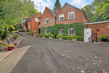
- Price
- Guide Price£1,750,000
- Size
- 8 acres
Off Tanworth Lane, Tanworth-in-Arden, B94, Solihull, Warwickshire B94 England
Added on 05/03/2026Equestrian property