Gaupieshaugh, St Cyrus, Aberdeenshire
- Land size
- 6.48 acres
- Bedrooms
- 3
- Bathrooms
- 1
Key Features
- Wonderful, private garden grounds extending to 0.21 hectares (0.51 acres).
- Adjacent field extending to 2.42 hectares (5.97acres).
- Adjoining workshops with huge potential for a range of uses including conversion to additional living, office or holiday let (subject to obtaining the necessary permissions).
- Private rural setting yet just 2 miles from St.Cyrus and the East Coast.
Description
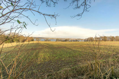
A rare opportunity to acquire a charming 3 bedroom detached cottage set within a large plot overlooking surrounding countryside and with the benefit of 2.42 hectares (5.97 acres) of useful grazing land.
FOR SALE AS A WHOLE
SITUATION
Gaupieshaugh has a wonderful rural setting just 2 miles to the west of the coastal village of St.Cyrus in beautiful south east Aberdeenshire. St.Cyrus is a popular village, renowned for its sweeping golden beach, dramatic volcanic cliffs and rich wildlife with its own protected nature reserve. The village has a well-regarded primary school, post office and general store. More extensive range of shopping, business and leisure facilities including sports centre and modern cinema are found in Montrose which is just 6 miles to the south.
Montrose also benefits from a main east coast railway station with regular services to Aberdeen, Dundee and Edinburgh. Secondary education is available in Montrose, Laurencekirk or Stonehaven. Lathallan is a reputable private school and located just 7 miles to the north.
Gaupieshaugh offers exceptional privacy with convenient accessibility being almost equidistant from Aberdeen and Dundee with both cities benefiting from an Airport and excellent transport links by road and rail.
South east Aberdeenshire is famed for its spectacular landscape, encompassing the nearby Angus Glens, rolling farmland, and dramatic coastline. The area offers a wealth of leisure opportunities and a first class quality of life in an unspoiled setting.
GENERAL DESCRIPTION
Gaupieshaugh is a charming single storey, detached country cottage tucked away from the public road behind a mature leylandii hedge. This private position benefits from far reaching views across surrounding countryside. The house benefits from a private drive, large garden and no immediate neighbours. Whilst some modernisation could be beneficial the property has been well maintained and loved by the current owners being their home for over 50 years.
The house is of traditional stone construction under a slate covered roof with UPVCU double glazed windows. The accommodation is detailed in the accompanying floor plans and set out as follows: Entrance hall with space for storing coats and shoes; kitchen with fitted wall and floor units and including stainless steel sink; lounge with open fire; rear hall with cupboard housing cold water tank; family shower/wet room shower, modern wash hand basin and wc; Single Bedroom; Two double bedrooms.
GARDENS
Enclosed gardens surround the house to three sides, predominantly laid to lawn with mature trees and hedging to the boundaries which provides shelter and privacy. There is a large area of gravelled parking area for several vehicles to the front and side of the house.
OUT BUILDINGS
Adjoining the house are two outbuildings/stores currently used for storage of the hot water tank, central heating boiler and firewood/tools. They buildings may have potential for a range of uses (subject to obtaining planning permission).
LAND
On the opposite side of the road to the Cottage, there is a field extending to 2.42 hectares (5.97 acres) currently laid to grass and used for mowing and grazing purposes. The field is relatively level and fences are in reasonable stock proof condition.
GENERAL INFORMATION
SERVICES
Water – Mains.
Electricity – Mains with solar panels providing an additional supply for house consumption.
Heating – Oil fired central heating. There is an open fire in the Sitting Room.
Sewage – Private septic tank located within the grounds.
THIRD PARTY RIGHTS & SERVITUDES
The subjects are sold together with and subject to all existing rights of way, easements, wayleaves and any other rights whether contained in the Title Deeds or otherwise, and purchasers will be deemed as satisfied themselves in respect thereof. To the best of the Seller’s knowledge, all boundary maintenance liabilities are shared equally with adjoining owners.
Please note that there is a mains gas and mains water supply pipe crossing the land. Further details available from the Selling Agents.
ACCESS
Access to the cottage and field is via the adjacent public road.
FIXTURES AND FITTINGS
All curtains and carpets are included in the sale. The white goods in the kitchen and some items of furniture may be available by separate negotiation.
LOCAL AUTHORITY
Aberdeenshire Council
Tel:
VIEWING
Viewings are strictly by appointment with FBR Seed Ltd. Viewers are advised to exercise caution.
DIRECTIONS
For the most accurate directions please use What3Words.
POSTCODE
DD10 0DR
TENURE
Freehold
METHOD OF SALE
The property is offered for sale as a whole with Vacant Possession via Private Treaty. A closing date for offers may be set, and interested parties are encouraged to register with the Selling Agents.
ENTRY AND POSSESSION
Entry and vacant possession will be by mutual agreement.
EPC RATING
Band D
COUNCIL TAX BAND
Band D
HOME REPORT
A Home Report incorporating a Single Survey, Energy Performance Certificate and Property Questionnaire is available for parties genuinely interested in this property. Please contact us, either by telephone or via the website entry for this property, to request a copy. No charge is made for electronic copies; a paper copy can also be made available from our offices or by post, at a charge of £20 to cover reproduction and administrative costs.
OFFERS
Offers, submitted in Scottish Legal Form, should be directed to the Selling Agents, FBR Seed Ltd. A closing date may be announced, and interested parties should register their interest after viewing the property. The Seller is not bound to accept the highest or indeed any offer.
APPORTIONMENTS
Council Tax and all other outgoings will be apportioned between the Seller and Purchaser as of the date of entry.
PLANS, AREAS AND SCHEDULES
The plans are based on the Ordnance Survey and are for reference purposes only. Purchasers must satisfy themselves regarding property descriptions, as errors or mis-statements will not annul the sale or entitle compensation.
ANTI-MONEY LAUNDERING (AML)REGULATIONS
As required under the 2017 AML Regulations, purchasers must provide identification for checks.
Acceptable ID includes:
a. Original primary (passport) and secondary (current council tax or utility bill) documents, or
b. Copies certified and dated by the purchaser’s solicitor along with confirmation that the Selling
Agents may rely on these for AML purposes.
Failure to provide this documentation may result in offers not being considered.
GUIDE TO INTERESTED PARTIES
While every effort has been made to ensure the accuracy of this information, we encourage prospective purchasers to contact us with any queries, particularly if travelling significant distances for a viewing. These particulars were prepared in September 2026.
IMPORTANT NOTICE
FBRSeed, their clients and any joint agents give notice that:
1. They are not authorised to make or give any representations or warranties in relation to the property either in writing or by word of mouth. Any information given is entirely without responsibility on the part of the agents or the sellers. These particulars do not form part of any offer or contract and must not be relied upon as statements or representations of fact.
2. Any areas, measurements or distances are approximate. The text, photographs and plans are for guidance only and are not necessarily comprehensive and it should not be assumed that the property remains as photographed. Any error, omission or misstatement shall not annul the sale, or entitle any party to compensation or recourse to action at law. It should not be assumed that the property has all necessary planning, building regulation or other consents, including for its current use. FBRSeed have not tested any services, equipment, or facilities. Purchasers must satisfy themselves by inspection or otherwise and ought to seek their own professional advice.
3. All descriptions or references to condition are given in good faith only. Whilst every endeavour is made to ensure accuracy, please check with us on any points of especial importance to you, especially if intending to travel some distance. No responsibility can be accepted for expenses incurred in inspecting properties which have been sold or withdrawn.
4. Anti-Money Laundering Regulation. The purchaser will be required to provide proof of ID to comply with anti-money laundering regulation.
Map Location
Property details
- Tenure
- Freehold
- Council Tax Band
- D
- Date Posted
- 2026-09-29
Market Value Analysis
Compared with 137 Homes with Land listings in Scotland (5+ acres).
Utilities & Restrictions
Utilities
- Electricity
- Mains
- Water
- Mains
- Heating
- Ask Agent
- Broadband
- Ask Agent
- Sewerage
- Septic Tank / Private
Rights & Restrictions
- Public Rights of Way
- Ask Agent
- Private Rights of Way
- Ask Agent
- Listed Property
- Ask Agent
- Restrictions
- Ask Agent
Listed status, conservation areas and planning constraints for this location are in the full report.
Property Features
- Accessibility
- Ask Agent
- Parking
- Parking Available
- Garden
- Garden
Beyond the particulars: planning activity, flood history, heritage and ground risks, checked for this exact spot.
Connectivity
Broadband
Fastest speed available at this postcode
1.8 Gbps
Gigabit full fibre
Suitable for
- 4K streaming on every screen
- Full-time home working
- Online gaming & big downloads
Mobile signal
Predicted 4G and 5G signal; indoor signal depends on building materials.
Ofcom Connected Nations postcode-level predictions. Speeds and signal are modelled, not measured, and vary between addresses and providers.
Signal is the easy part. Planning activity, flood history and protected designations here are in the full report.
Nearest Schools
Primary
- St Cyrus School1.9 miles
- Pupils
- 122
- Type
- Non-denominational
- Marykirk School2.3 miles
- Pupils
- 38
- Type
- Non-denominational
- Laurencekirk School2.7 miles
- Pupils
- 386
- Type
- Non-denominational
- Rosemount Primary School3.3 miles
- Pupils
- 181
- Type
- Non-denominational
- Luthermuir School4 miles
- Pupils
- 28
- Type
- Non-denominational
Secondary
- Mearns Academy3.4 miles
- Pupils
- 687
- Type
- Non-denominational
- Montrose Academy5.5 miles
- Pupils
- 859
- Type
- Non-denominational
- Brechin High School9.1 miles
- Pupils
- 562
- Type
- Non-denominational
- Mackie Academy15 miles
- Pupils
- 1,118
- Type
- Non-denominational
- Arbroath Academy16 miles
- Pupils
- 683
- Type
- Non-denominational
Distances are straight-line from the advertised location. Source: the national school registers (DfE, Welsh Government, Scottish Government) and Ofsted.
Schools are just the start: planning activity, heritage and any flood history here are in the full report.
Amenities
Supermarket
GP surgery
Pharmacy
Straight-line distances from the advertised location. Sources: NHS records, Geolytix supermarket locations, OS Open Greenspace and the national trails registers.
The area stacks up? Now check the location itself: planning nearby, protected designations and past flooding.
Getting Around
Nearest station
Nearest bus stop
Typical drive times
Straight-line distances from the advertised location; drive times are typical free-flow times over OpenStreetMap road data, so allow more at peak. Public transport locations from DfT NaPTAN.
Easy to reach matters. So do planning activity, flood history and ground risks: all in the full report.
Flood Risk
SEPA open data, checked around the advertised map pin for the listed acreage. Provided by LandSale, not the listing agent, and not part of the agent's particulars. Risk varies across a holding, so verify before committing.
Rivers and the sea
Surface water
These bandings are the summary. Where this location sits on the flood maps, plus planning activity, heritage and ground risks, is in the full report.
Important notice: Information, maps and tags on this page are drawn from the advertising agent's marketing materials or generated automatically. LandSale has not verified them. Relying on these details is at your own risk, always carry out independent checks before committing to a purchase.
LandSale full disclaimer
Marketing information only - not formal particulars. The details on this website are provided for general guidance and do not constitute an offer or contract. Neither LandSale nor the advertising estate/land agent accepts responsibility for any inaccuracy.
1. Source of information
- Listing content: Core description, asking price, tenure, measurements, photographs and planning history originate from the marketing materials of the advertising estate or land agent. LandSale does not author this content and cannot guarantee its accuracy.
- Automated tags & categorisation: Property type, land-use class, acreage bands and similar labels may be applied by machine-learning models. They are intended as a helpful guide only and may not reflect the property's legal status or permitted use.
- Third-party & enriched data layers: Maps, boundary outlines, planning designations, soil reports, broadband coverage and other environmental or location-based insights are licensed from external suppliers. Such data are supplied “as is", may be incomplete or out of date and are subject to change without notice.
2. Verification required
Prospective purchasers must verify critical matters, including but not limited to planning permission, title boundaries, public rights of way, environmental constraints, acreage, services, access and VAT status, through their own inspections, specialist surveys, legal advisers and the selling agent before relying on the information or entering into any contract.
3. No warranty or liability
LandSale gives no warranty, express or implied, as to the accuracy, completeness or fitness for any particular purpose of the information displayed. LandSale shall not be liable for any loss, damage, cost or expense arising directly or indirectly from any use of or reliance on such information, save where liability may not be excluded by law.
4. Updates & feedback
If you believe any detail on this listing is inaccurate, please let us know. We will investigate and, where appropriate, update the listing or notify the agent.
© LandSale | Version 1.3 - August 2026
Listing agent
FBR SEED, Kelso
Rose Lane, Kelso, TD5 7AP
Similar properties for sale
- Price
- Offers Over£219,000
- Size
- 0.83 acres
Added on 29/01/2026Self Build Plot
- Price
- Offers Over£198,000
- Size
- 4.73 acres
Added on 29/01/2026Building Plot
- Price
- Offers Over£198,000
- Size
- 3.3 acres
Fasque Estate, Aberdeenshire, AB30, West Aberdeenshire and Kincardine, Aberdeenshire AB30 Scotland
Added on 29/01/2026Building Plot
- Price
- Offers Over£180,000
- Size
- 0.45 acres
Added on 29/01/2026Building Plot
- Price
- Offers Over£290,000
Inverkeilor, Arbroath, DD11, Arbroath and Broughty Ferry, Angus DD11 Scotland
Added on 29/01/2026Barn Conversion
- Price
- Fixed Price£350,000
- Size
- 1.18 acres
Inverkeilor, Arbroath, DD11, Arbroath and Broughty Ferry, Angus DD11 Scotland
Added on 29/01/2026Building Plot
- Price
- Offers in Region of£275,000
62 Contlaw Road, Milltimber, Aberdeen, AB13, Aberdeen South, Aberdeen City AB13 Scotland
Added on 09/10/2026Development Land
- Price
- Offers Over£180,000
Lumphanan, Banchory, AB31, West Aberdeenshire and Kincardine, Aberdeenshire AB31 Scotland
Added on 17/07/2026Development Land
- Price
- Offers in Region of£350,000
Drumgeith Road, Dundee, DD4, Arbroath and Broughty Ferry, Dundee City DD4 Scotland
Added on 10/05/2026Development Land
- Price
- Fixed Price£165,000
- Size
- 0.23 acres
Strathern Road, Dundee, DD5, Dundee Central, Dundee City DD4 Scotland
Added on 18/08/2026Building Plot