Bickley Town Farm, Nr Cholmondeley, Bickley, Malpas, Cheshire SY14
- Land size
- 3.19 acres
- Bedrooms
- 5
- Bathrooms
- 1
Key Features
- 5 bedroom farmhouse
- Entrance hall,WC, Boot/Cloak room
- 3 reception rooms
- kitchen/breakfast room with pantry
- 5 bedrooms and family bathroom
- 3 large attic rooms with windows (potential accommodation)
- Landscaped south easterly facing gardens
- Large range of agricultral outbuildings with potential for residential/equestrain use
- In all about 3.19 acres
- Lot 2 about 6.94 acres with further land available
Description
DEVELOPMENT OPPORTUNITY OF INTEREST TO DEVELOPERS, INVESTORS & PRIVATE INDIVIDUALS
A PERIOD 5 BEDROOM FARMHOUSE IN NEED OF RENOVATION, WITH A LARGE RANGE OF OUTBUILDINGS IDEAL FOR AGRICULTURAL/EQUESTRAIN USE OR DEVELOPMENT, WITH PLANNING PERMISSION APPLIED FOR 5 DWELLINGS, SITTING IN A TOTAL OF 10.13 ACRES
SOLD AS A WHOLE OR AS TWO SEPEARTE LOTS
AS A WHOLE INCLUDING BOTH LOTS £1,250,000
LOT 1 – HOUSE AND BUILDINGS STANDING IN 3.19 ACRES £1,100,000
LOT 2 – AGRICULTURAL LAND OF ABOUT 6.94 ACRES £150,000
**NO CHAIN**
Lot 1 - Main House
•Entrance hall
•Separate WC
•Boot/cloak room
•3 reception rooms
•Study
•Kitchen/breakfast room with Pantry
•Utility room
•5 bedrooms
•Family bathroom
•Three large attic rooms with windows (potential accommodation)
•Landscaped south easterly facing gardens
•Various store rooms
•Large parking area to rear with car port
OUTBUILDINGS WITH POTENTIAL FOR RESIDENTIAL CONVERSION
•Planning application applied for, for 5 dwellings with garaging in the following outbuildings:-
•A large range of brick and steel portal framed buildings of various sizes amounting to 28,733 sq ft ( 2669.4 sq m)
•Large area of hardstanding with separate access to outbuildings
•Paddock land behind buildings
•In all about 3.19 acres
Lot 2 - •A large field laid down to grass with separate road access about 6.94 acres
•Further land may be available
Description - Bickley Town Farm is a handsome farmstead with significant development potential and a substantial period farmhouse requiring a scheme of renovation. The house enjoys an elevated position with far reaching south easterly views across Cholmondeley Estate land.
The attractive period farmhouse has cream rendered elevations with diamond lattice windows, all surmounted by a slate roof. The handsome period façade sets the scene for a wonderful interior with a suite of large rooms, with a flexible layout, laid out over two floors, ideal for the family buyer. There is potential for more accommodation to the third floor with three large attic rooms all with windows, but currently only accessed via a step ladder. The house has such period features as beamed ceilings and period fireplaces.
There is an entrance hall, with WC and boot/cloak room, a large kitchen breakfast room with pantry and three good sized reception rooms, all with fireplaces. Two sets of stairs lead to the first floor with five generously proportioned bedrooms all served by a family bathroom.
To the rear and side elevations lie eight large agricultural barns of various ages and construction, which are ripe for development or ideal for agricultural or equestrian use. The outbuildings have their own separate access off the lane. Plans have been drawn up with planning approval being sought for the following accommodation:-
PROPOSED ACCOMMODATION:
See drawings:
BARN A
Unit 1 - 1058 sq ft (98.4 sq m) 3 bedrooms
Unit 2 – 645 sq ft (60.0 sq m) 2 bedrooms
Unit 3 – 1194 sq ft (111.0 sq m) 3 bedrooms
BARN B
Unit 4 – 2,568 sq ft (238.7 sq m) 4 bedrooms
BARN C
Unit 5 – 2,558 sq ft (237.8 sq m) 4 bedrooms
PARTS OF REMAINING BARNS TO BE CONVERTED INTO GARAGING/PARKING
Gardens & Grounds - There are two gated entrances, one to the house and one to the majority of the outbuildings/agricultural yard. There is an attractive cobbled yard to the rear of the house that fronts two of the barns, with a larger area of hard standing lying between the remining outbuildings. To the front of the house and benefiting from the breathtaking rural views lies a large level lawned garden with mature specimen trees.
Location - Bickley Town Farm occupies an enviable rural and elevated position within the peaceful rural hamlet of Bickley Town, one of South Cheshire's most desirable countryside locations. Surrounded in the main by Cholmondeley Estate farmland and stunning rural landscapes whilst remaining exceptionally well connected to the region's principal commercial centres. The nearby village of Malpas, approximately 2.5 miles away, is renowned for its historic character, thriving community and excellent range of everyday amenities, making this an outstanding location for those seeking the very best of country living.
The attractive village of Malpas offers a comprehensive selection of independent retailers, cafés, public houses, a medical practice, pharmacy, post office and convenience shopping, together with the highly regarded Bishop Heber High School, consistently recognised as one of the area's leading secondary schools. Whitchurch is a thriving town and is only 6 miles distant with further shopping and leisure facilities found in the historic city of Chester (approximately 16 miles), whilst the thriving centres of Nantwich (approximately 10 miles), Wrexham (approximately 15 miles) and Shrewsbury (approximately 27 miles) provide an extensive choice of boutiques, supermarkets, restaurants and cultural attractions.
The area is particularly well regarded for its recreational opportunities. Cholmondeley Castle and Gardens, with its magnificent parkland and seasonal events, lies just a few minutes away, while Beeston Castle, Peckforton Castle, the Sandstone Trail, Bickerton Hills, Combermere Abbey and Delamere Forest all offer exceptional walking, cycling and outdoor pursuits. The nearby Carden Park Hotel, Golf Resort & Spa, less than 5 miles away, provides two championship golf courses, luxury spa facilities and fine dining, making it one of the region's premier leisure destinations.
The surrounding countryside is renowned for its exceptional collection of traditional inns and acclaimed dining destinations. Nearby favourites include The Cholmondeley Arms, a characterful country pub set within the former village school, with a tennis and paddle club adjoining; The Lion at Malpas, a popular destination for both fine dining and relaxed lunches; The Carden Arms at Tilston; and The Bickerton Poacher, all within a short drive and highly regarded throughout Cheshire and North Wales.
For commuters, the property offers excellent accessibility. Railway stations at Whitchurch (approximately 5 miles), Wrenbury (approximately 5 miles) and Nantwich (approximately 10 miles) provide regular regional services, whilst Crewe Station, approximately 17 miles away, offers frequent high-speed rail connections to London Euston in around 1 hour 30 minutes, making the property entirely practical for those travelling regularly to the capital.
Road communications are equally impressive. The A41 is easily accessible and provides direct routes to Chester and Whitchurch, connecting with the wider road network via the A49, A534, M53, M56 and M6, placing the commercial centres of the Northwest and Midlands within comfortable commuting distance.
Distances In Apprx Miles: - Malpas 2.5 m, Whitchurch 6 m| Tarporley 10 m| Nantwich 10 m | Chester 16 m| Crewe 17 m| Shrewsbury 27 m| Manchester 44 m| Liverpool 34 m
Directions - Postcode: SY14 8EQ
What 3 Words: texted.brew.sublime
From Tarporley, take the A49 in a southerly direction for about 8 miles, passing the Cholmondeley Arms public house on your left hand side. Having passed Bewilderwood, bear right at the first set of crossroads into Bickley Lane. Just before the third road to your right, Bickley Town Farm will be seen on your right-hand side.
Property Informtion - TENURE: Freehold
EPC: F
SERVICES:
Mains water, electricity, septic tank drainage, oil fired central heating. Electricity and water to some buildings. Three phase electricity to the buildings.
LOCAL AUTHORITY: Chester West & Chester
COUNCIL TAX BAND: F amount payable for 2026 - £2,636
Agents Notes - · At the time of printing the planning application had been submitted.
· The plans & drone shots are for identification only and not be relied upon.
· No offers will be accepted subject to planning being obtained.
· The acreage stated for both lots is a guide only as the exact boundaries are yet to be erected.
· Any gaps in the boundary fenceline are to be fenced at the buyer’s expense, to the satisfaction of the Cholmondeley Estate. It is to be two post and railed netted fence. This is to be erected within three months from completion.
· There is a public footpath that crosses Lot 2.
Exceptions And Reservations - •Sporting rights
•Mines and minerals
•Right to use any sewers, drains, watercourses, pipes, cables, channels or conduits laid now or in the future and the power at any time to make connections, repair, renew, maintain and cleanse
•Any necessary access rights
Restrictive Covenants - •For the long term preservation of the character and aesthetics of the settlements within The Cholmondeley Estate boundary, the Cholmondeley Estate asks for the following reservations, exceptions and covenants listed below:-
•Not to build or allow to be built on the property any structure of any description or alter the buildings unless and until the plans and specification have been approved in writing by the seller. The principle is accepted that the farm buildings can be developed to form separate residential units or an agricultural/equestrian facility or business.
•Not to be a nuisance or annoyance to the owners or occupiers of any part of the seller’s adjoining land.
•Not to park or allow to remain on the property any caravan or mobile home without having previous written consent of the seller.
•Not to whitewash or colourwash any part of the buildings on the property not formerly so treated.
•Not to fell any trees, shrubs or hedges, except in accordance with good arboricultural practice.
•To keep gardens properly cultivated.
•Not to display any poster, sign hoarding or advertisement on the property except as shall relate to its sale or letting or locator/guide signs.
•Not to interfere or disrupt services or conducting media laid to the adjoining property.
Map Location
Property details
- Tenure
- Freehold
- Council Tax Band
- F
- Date Posted
- 2026-09-10
Market Value Analysis
Compared with 139 Development Land listings in North West England (1+ acres).
Energy Performance Certificate
Energy Efficiency Rating
Based on UK Energy Performance Certificate standards (EU Directive 2002/91/EC)
Running costs are one side. Planning activity, flood history and ground risks for this location are in the full report.
Utilities & Restrictions
Utilities
- Electricity
- Mains
- Water
- Mains
- Heating
- Oil Heating
- Broadband
- Ask Agent
- Sewerage
- Septic Tank / Private
Rights & Restrictions
- Public Rights of Way
- Ask Agent
- Private Rights of Way
- Ask Agent
- Listed Property
- Ask Agent
- Restrictions
- Ask Agent
Listed status, conservation areas and planning constraints for this location are in the full report.
Property Features
- Accessibility
- Ask Agent
- Parking
- Parking Available
- Garden
- Garden
Beyond the particulars: planning activity, flood history, heritage and ground risks, checked for this exact spot.
Connectivity
Broadband
Fastest speed available at this postcode
900 Mbps
Gigabit full fibre
Suitable for
- 4K streaming on every screen
- Full-time home working
- Online gaming & big downloads
Mobile signal
Outdoor predictions; indoor signal depends on building materials.
Ofcom Connected Nations postcode-level predictions. Speeds and signal are modelled, not measured, and vary between addresses and providers.
Signal is the easy part. Planning activity, flood history and protected designations here are in the full report.
Nearest Schools
Primary
- Tushingham With Grindley CofE Primary School1.6 milesOfsted: Good *
- Ages
- 3 to 11
- Pupils
- 113
- Type
- Voluntary controlled school
- Faith
- Church of England
- Malpas Alport Endowed Primary School2.9 milesOfsted report card · Nov 2025
- Ages
- 2 to 11
- Pupils
- 261
- Type
- Community school
- Bickerton Holy Trinity CofE Primary School3 milesOfsted: Good
- Ages
- 4 to 11
- Pupils
- 101
- Type
- Voluntary controlled school
- Faith
- Church of England
- Wrenbury Primary School4.1 milesNo Ofsted rating
- Ages
- 3 to 11
- Pupils
- 134
- Type
- Community school
- Whitchurch CofE Junior Academy4.4 milesOfsted: Good
- Ages
- 7 to 11
- Pupils
- 304
- Type
- Academy sponsor led
- Faith
- Church of England
Secondary
- Bishop Heber High School2.6 milesOfsted: Good
- Ages
- 11 to 18
- Pupils
- 1,293
- Type
- Foundation school
- Sir John Talbot's School5.2 milesOfsted: Good
- Ages
- 11 to 19
- Pupils
- 861
- Type
- Academy sponsor led
- Malbank School and Sixth Form College7.3 milesOfsted: Good
- Ages
- 11 to 18
- Pupils
- 1,289
- Type
- Academy converter
- Brine Leas School7.9 milesNo Ofsted rating
- Ages
- 11 to 18
- Pupils
- 1,417
- Type
- Academy converter
- Tarporley High School and Sixth Form College8.5 milesOfsted: Good
- Ages
- 11 to 18
- Pupils
- 1,219
- Type
- Academy converter
* Latest graded judgement covers quality of education only; no overall grade was issued under the 2024-25 inspection framework.
Distances are straight-line from the advertised location. Source: the national school registers (DfE, Welsh Government, Scottish Government) and Ofsted.
Schools are just the start: sold prices nearby, planning activity and any flood history are in the full report.
Amenities
Supermarket
GP surgery
Pharmacy
Hospital
Green space
Straight-line distances from the advertised location. Sources: NHS records, Geolytix supermarket locations, OS Open Greenspace and the national trails registers.
The area stacks up? Now check the location itself: planning nearby, protected designations and past flooding.
Getting Around
Nearest station
Nearest bus stop
Typical drive times
Straight-line distances from the advertised location; drive times are typical free-flow times over OpenStreetMap road data, so allow more at peak. Public transport locations from DfT NaPTAN.
Easy to reach matters. So do planning activity, flood history and ground risks: all in the full report.
Flood Risk
From Environment Agency flood map open data, checked around the advertised map pin and allowing for the listed acreage where known. This summary comes from LandSale, the advertising platform, not from the listing agent, and is not part of the agent's particulars. Risk can vary across a single holding, so verify anything critical through your own searches before committing.
Rivers and the sea
Surface water
The detail behind these bandings
The full report pinpoints where this location sits on the flood maps, and runs the deeper checks that usually only surface after an offer.
- Exact flood zones & annual chances (included in the full report)
- Any recorded past flooding (included in the full report)
- Planning activity nearby (included in the full report)
- Heritage & conservation (included in the full report)
- Protected nature designations (included in the full report)
- Ground risks (included in the full report)
- Sold prices nearby (included in the full report)
£14.99 · one-off purchase
By LandSale, the platform. Not provided by the listing agent. Ready in about a minute.
Important notice: Information, maps and tags on this page are drawn from the advertising agent's marketing materials or generated automatically. LandSale has not verified them. Relying on these details is at your own risk, always carry out independent checks before committing to a purchase.
LandSale full disclaimer
Marketing information only - not formal particulars. The details on this website are provided for general guidance and do not constitute an offer or contract. Neither LandSale nor the advertising estate/land agent accepts responsibility for any inaccuracy.
1. Source of information
- Listing content: Core description, asking price, tenure, measurements, photographs and planning history originate from the marketing materials of the advertising estate or land agent. LandSale does not author this content and cannot guarantee its accuracy.
- Automated tags & categorisation: Property type, land-use class, acreage bands and similar labels may be applied by machine-learning models. They are intended as a helpful guide only and may not reflect the property's legal status or permitted use.
- Third-party & enriched data layers: Maps, boundary outlines, planning designations, soil reports, broadband coverage and other environmental or location-based insights are licensed from external suppliers. Such data are supplied “as is", may be incomplete or out of date and are subject to change without notice.
2. Verification required
Prospective purchasers must verify critical matters, including but not limited to planning permission, title boundaries, public rights of way, environmental constraints, acreage, services, access and VAT status, through their own inspections, specialist surveys, legal advisers and the selling agent before relying on the information or entering into any contract.
3. No warranty or liability
LandSale gives no warranty, express or implied, as to the accuracy, completeness or fitness for any particular purpose of the information displayed. LandSale shall not be liable for any loss, damage, cost or expense arising directly or indirectly from any use of or reliance on such information, save where liability may not be excluded by law.
4. Updates & feedback
If you believe any detail on this listing is inaccurate, please let us know. We will investigate and, where appropriate, update the listing or notify the agent.
© LandSale | Version 1.3 - August 2026
Listing agent
Larch Property, Preston On Severn
Franks Barn, Preston On Severn, Uffington, SY4 4TB
Contact Larch Property, Preston On Severn
Franks Barn, Preston On Severn, Uffington, SY4 4TB
View agent profileSimilar properties for sale
- Price
- Guide Price£850,000
- Size
- 4.2 acres
Stapeley Farm, London Road, Nantwich, CW5, Stapeley and District, Cheshire East CW5 England
Added on 22/06/2026Development Land
- Price
- Offers Over£850,000
- Size
- 4 acres
The Limes, Holme Street, Tarvin, Chester, Barrow, Cheshire West and Chester CH3 England
Added on 08/08/2026Development Land
- Price
- Offers in Excess of£1,000,000
- Size
- 7.5 acres
Thorn Tree Farm, Ainsworth Lane, Crowton, Northwich, Crowton, Cheshire West and Chester CW8 England
Added on 11/09/2026Development Land
- Price
- £1,200,000
- Size
- 2 acres
Cinder Lane, Over Peover, WA16, Peover Superior and Snelson, Cheshire East WA16 England
Added on 09/04/2026Redevelopment Land
- Price
- Offers Over£1,000,000
- Size
- 1 acres
Whisterfield Lane, Siddington, SK11, Siddington, Cheshire East SK11 England
Added on 21/07/2026Development Land
- Price
- £900,000
- Size
- 2 acres
Added on 29/04/2026Development Land
- Price
- Offers in Region of£875,000
- Size
- 8.92 acres
Added on 09/07/2026Development Land
- Price
- Offers in Region of£1,300,000
- Size
- 1.79 acres
Jeffrey Meadows Farm, Nabb Lane, Alton, Alton, Staffordshire ST10 England
Added on 18/08/2026Development Land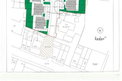
- Price
- Offers in Region of£1,025,000
- Size
- 1.1 acres
Atherton Road, Hindley Green, WN2, Makerfield, Wigan WN2 England
Added on 05/06/2026Development Land