Bank Farm, Whitchurch Road, Tiverton, Chester, Cheshire West And Chester
- Land size
- 5.14 acres
- Bedrooms
- 5
Description
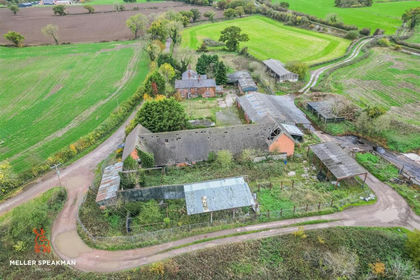
An exceptional development opportunity comprising an attractive farmhouse and impressive range of traditional farm buildings with full planning consent for conversion to five residential dwellings in a private yet accessible rural location. In all approximately 5.14 acres (2.08 hectares).
Full planning consent for five high-quality residential dwellings in
addition to the existing farmhouse
• Attractive range of red-brick traditional farm buildings within an
established Cheshire farmstead
• Character features including arched openings, circular pitching
eyes and timber trusses
• Private gardens and parking for each dwelling, as per the
approved plans
• Rural setting with views across open countryside
• Convenient access to local villages, market towns and regional
transport links
• Substantial existing farmhouse with scope for renovation to
high-quality family home
• 3 acres of paddocks and amenity land surrounding farmhouse
and buildings
• Available freehold with vacant possession
Introduction
Tiverton Bank Farm offers an excellent opportunity to acquire a prime development site well-located in the picturesque village of Tiverton with expansive views over open countryside and Beeston and Peckforton Castles. The site benefits from planning consent to convert the range of traditional farm buildings to five bespoke dwellings in addition to the existing substantial farmhouse along with approximately 3 acres (1.264 hectares) of paddocks and amenity land. In total, the site comprises 5.14 acres (2.08hectares).
Situation & Access
The site is ideally positioned near the A51 between Chester,12 miles to the northwest and Crewe, 13 miles tothe southeast. The larger village and popular local centre
of Tarporley is just 2 miles away offering a comprehensive range of services, retail and schools.Tiverton village is located in a highly sought-after anddesirable region of Cheshire. The area is well regarded for its combination of rural landscapes and accessibility. The village benefits from excellent road connections to the wider Northwest region and the national road network, including the M6 just 18 miles away. The town of Crewe offers a mainline rail connection providing services to Manchester, Birmingham and London. The site is situated east of the centre of the village ofTiverton and is approached via an established private drive leading directly from the A49 Whitchurch Road. The site occupies an elevated position set back from the highway,with uninterrupted views over the surrounding Cheshire
countryside.
Property Description
Tiverton Bank Farm is a redundant farmyard and farmhouse with an approved planning consent for the buildings to be converted into five high-quality residential properties. The approved scheme includes four three-bedroom dwellings,two of which are semi-detached and one large contemporary five-bedroom property. This is in addition to the existing large five-bedroom farmhouse with potential to be refurbished to become an exceptional family home.The consented site layout is shown on the plan, with accommodation details in the table below.Each home benefits from a private garden in addition to private parking areas. The development is designed to besympathetic to the Site’s agricultural past, combining period characteristics with contemporary family living.
Surrounding the farmhouse and farm buildings, is approximately 3 acres (1.264 hectares) of additional paddock land which offers the potential to enhance the amenity of the consented dwellings or explore further development opportunities subject to obtaining the necessary consents.
Planning & Conditions
The Property falls under the jurisdiction of Cheshire West and Chester Council and benefits from full planning consent (Ref: 23/00133/FUL) granted on 26 August 2026.
The Purchaser(s) will be required to comply fully with the approved consent.
All planning documents and approved drawings are available via the Local Planning Authority’s website or from the selling agents upon request.
General Remarks
Method of sale
The property is offered for sale by private treaty as a whole.
Tenure & possession
Freehold with vacant possession available upon completion.
services
The Property is connected to mains water, drainage, and electrical services, but buyers must satisfy themselves as to the availability and capacity of mains services required for development.
Overage
The property is to be sold subject to an overage provision on the land shown hatched grey on the sale plan. The formular will seek to capture 30% of the uplift in value for a period of 30 years. The overage will be triggered on the implementation of an additional or revised planning consent or subsequent sale of the property with planning consent, whichever is earlier.The overage will be protected by restriction which will take priority over any first legal charge on the buyer’s registeredtitle on completion.
Value Added Tax
Tiverton Bank Farm has been opted to tax for VAT purposes (excluding the farmhouse) and VAT will therefore be due at the standard rate in addition to any agreed price. The buyer may or may not be entitled to recover VAT from the HM Revenue & Customs. We would advise that the buyer takes independent professional advice in respect of their VAT position and in relation to this transaction.
Exchange & Completion
A deposit of 10% of the agreed price will be payable on exchange of contracts with completion date to be agreed between the parties.
Anti-money laundering
To comply with the Money Laundering Regulations 2017 (as amended), one an offer letter is accepted, the purchaser(s) will be required to provide any information requested in order to undertake the relevant due diligence. This is a legal requirement.
Wayleaves, Easements & Rights of Way
The property is sold subject to, or with the benefit of existing wayleaves, easements, quasi-easements, rights of way, covenants and restrictions whether mentioned in these particulars or not. The property is sold subject to public rights of way and a plan is available on request from the selling agents. The purchaser(s) will be deemed to have full knowledge and will have satisfied themselves as to theprovisions of any such matters affecting the property.
Sporting, Minerals & Timber
All such rights are included in so far as they are owned by the vendor.
Plans, Areas & Boundaries
Plans attached to these particulars are based upon Ordnance Survey National Grid and are for reference only. The purchaser(s) will be deemed to satisfy themselves of the property as shown.
The vendor and the vendor’s agent will do their best to specify the ownership of the boundary hedges, fences and ditches but will not be bound to determine these. The purchaser(s) will have to satisfy themselves as to the ownership of boundaries.
The Purchaser will be responsible for the boundaries shown with inward facing ‘T’ marks.
Fixtures & Fittings
The purchaser(s) should assume that all fixtures and fittings are included in this sale.
Data Room
A Data Room has been set up with a suite of information on this opportunity. Interested parties will need to register with the selling agents for access to this facility.
Local Authority
Cheshire West and Chester Council
Regulatory Services HQ, Nicholas Street, Chester, CH1 2NP W:
T:
Vendors Solicitors
Mills & Reeve Botanic House, 100 Hills Road, Cambridge, CB2 1PH
Postcode
Nearest Postcode: CW6 9NA
What3words
The entrance to the property is located at: ///evenings.town.cassettes
Registered Title
The property forms part of Title No. CH605884.
Photographs
The photographs shown in these particulars were taken
November 2025 and June 2026. Some of the images are CGI generated.
Sale Particulars
These particulars were prepared August 2026.
Energy Performance Certificate
Tiverton Bank Farmhouse has an EPC rating of E which expires 29 June 2036.
Health & Safety
Due to the nature of the buildings, viewers are asked to take particular care during inspection. Uneven surfaces, low beams and redundant structures may be present. Children must be supervised at all times.
Viewing
Viewing is strictly by prior appointment only with the vendor’s agents.
Map Location
Property details
- Tenure
- Freehold
- Council Tax Band
- G
- Date Posted
- 2026-09-14
Market Value Analysis
Compared with 36 Development Land listings in North West England (5+ acres).
Utilities & Restrictions
Utilities
- Electricity
- Ask Agent
- Water
- Ask Agent
- Heating
- Ask Agent
- Broadband
- Ask Agent
- Sewerage
- Ask Agent
Rights & Restrictions
- Public Rights of Way
- Ask Agent
- Private Rights of Way
- Ask Agent
- Listed Property
- Ask Agent
- Restrictions
- Ask Agent
Listed status, conservation areas and planning constraints for this location are in the full report.
Property Features
- Accessibility
- Ask Agent
- Parking
- Parking Available
- Garden
- Garden
Beyond the particulars: planning activity, flood history, heritage and ground risks, checked for this exact spot.
Connectivity
Broadband
Fastest speed available at this postcode
1.8 Gbps
Gigabit full fibre · available to 94% of premises
Suitable for
- 4K streaming on every screen
- Full-time home working
- Online gaming & big downloads
Mobile signal
Outdoor predictions; indoor signal depends on building materials.
Ofcom Connected Nations postcode-level predictions. Speeds and signal are modelled, not measured, and vary between addresses and providers.
Signal is the easy part. Planning activity, flood history and protected designations here are in the full report.
Nearest Schools
Primary
- Tarporley CofE Primary School1.4 milesNo Ofsted rating
- Ages
- 4 to 11
- Pupils
- 259
- Type
- Voluntary controlled school
- Faith
- Church of England
- Bunbury Aldersey CofE Primary School1.5 milesOfsted: Good
- Ages
- 2 to 11
- Pupils
- 200
- Type
- Academy converter
- Faith
- Church of England
- Eaton Primary School2.3 milesOfsted: Good
- Ages
- 5 to 11
- Pupils
- 175
- Type
- Academy sponsor led
- Huxley CofE Primary School2.7 milesOfsted: Inadequate
- Ages
- 5 to 11
- Pupils
- 63
- Type
- Academy sponsor led
- Faith
- Church of England
- Calveley Primary Academy3.4 milesOfsted: Outstanding *
- Ages
- 2 to 11
- Pupils
- 118
- Type
- Academy converter
Secondary
- Tarporley High School and Sixth Form College1.1 milesOfsted: Good
- Ages
- 11 to 18
- Pupils
- 1,219
- Type
- Academy converter
- The Winsford Academy6.7 milesOfsted: Inadequate *
- Ages
- 11 to 16
- Pupils
- 945
- Type
- Academy sponsor led
- Malbank School and Sixth Form College7.3 milesOfsted: Good
- Ages
- 11 to 18
- Pupils
- 1,289
- Type
- Academy converter
- Christleton High School7.6 milesOfsted: Good
- Ages
- 11 to 18
- Pupils
- 1,382
- Type
- Academy converter
- Bishop Heber High School8.4 milesOfsted: Good
- Ages
- 11 to 18
- Pupils
- 1,293
- Type
- Foundation school
* Latest graded judgement covers quality of education only; no overall grade was issued under the 2024-25 inspection framework.
Distances are straight-line from the advertised location. Source: the national school registers (DfE, Welsh Government, Scottish Government) and Ofsted.
Schools are just the start: sold prices nearby, planning activity and any flood history are in the full report.
Amenities
Supermarket
GP surgery
Pharmacy
Hospital
Green space
Straight-line distances from the advertised location. Sources: NHS records, Geolytix supermarket locations, OS Open Greenspace and the national trails registers.
The area stacks up? Now check the location itself: planning nearby, protected designations and past flooding.
Getting Around
Nearest station
Nearest bus stop
Typical drive times
Straight-line distances from the advertised location; drive times are typical free-flow times over OpenStreetMap road data, so allow more at peak. Public transport locations from DfT NaPTAN.
Easy to reach matters. So do planning activity, flood history and ground risks: all in the full report.
Flood Risk
From Environment Agency flood map open data, checked around the advertised map pin and allowing for the listed acreage where known. This summary comes from LandSale, the advertising platform, not from the listing agent, and is not part of the agent's particulars. Risk can vary across a single holding, so verify anything critical through your own searches before committing.
Rivers and the sea
Surface water
Mapped within the area searched, not at the advertised map pin itself.
The detail behind these bandings
The full report pinpoints where this location sits on the flood maps, and runs the deeper checks that usually only surface after an offer.
- Exact flood zones & annual chances (included in the full report)
- Any recorded past flooding (included in the full report)
- Planning activity nearby (included in the full report)
- Heritage & conservation (included in the full report)
- Protected nature designations (included in the full report)
- Ground risks (included in the full report)
- Sold prices nearby (included in the full report)
£14.99 · one-off purchase
By LandSale, the platform. Not provided by the listing agent. Ready in about a minute.
Important notice: Information, maps and tags on this page are drawn from the advertising agent's marketing materials or generated automatically. LandSale has not verified them. Relying on these details is at your own risk, always carry out independent checks before committing to a purchase.
LandSale full disclaimer
Marketing information only - not formal particulars. The details on this website are provided for general guidance and do not constitute an offer or contract. Neither LandSale nor the advertising estate/land agent accepts responsibility for any inaccuracy.
1. Source of information
- Listing content: Core description, asking price, tenure, measurements, photographs and planning history originate from the marketing materials of the advertising estate or land agent. LandSale does not author this content and cannot guarantee its accuracy.
- Automated tags & categorisation: Property type, land-use class, acreage bands and similar labels may be applied by machine-learning models. They are intended as a helpful guide only and may not reflect the property's legal status or permitted use.
- Third-party & enriched data layers: Maps, boundary outlines, planning designations, soil reports, broadband coverage and other environmental or location-based insights are licensed from external suppliers. Such data are supplied “as is", may be incomplete or out of date and are subject to change without notice.
2. Verification required
Prospective purchasers must verify critical matters, including but not limited to planning permission, title boundaries, public rights of way, environmental constraints, acreage, services, access and VAT status, through their own inspections, specialist surveys, legal advisers and the selling agent before relying on the information or entering into any contract.
3. No warranty or liability
LandSale gives no warranty, express or implied, as to the accuracy, completeness or fitness for any particular purpose of the information displayed. LandSale shall not be liable for any loss, damage, cost or expense arising directly or indirectly from any use of or reliance on such information, save where liability may not be excluded by law.
4. Updates & feedback
If you believe any detail on this listing is inaccurate, please let us know. We will investigate and, where appropriate, update the listing or notify the agent.
© LandSale | Version 1.3 - August 2026

Listing agent
Rostons, Hatton Heath
West View House Whitchurch Road, Hatton Heath, CH3 9AU
Call agent
01829773000Contact Rostons, Hatton Heath
West View House Whitchurch Road, Hatton Heath, CH3 9AU
Call agent
01829773000Similar properties for sale
- Price
- Offers in Region of£1,500,000
- Size
- 2.68 acres
Stoke Hall Lane, Poole, Nantwich, Stoke and Hurleston, Cheshire East CW5 England
Added on 29/01/2026Conversion Land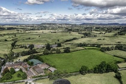
- Price
- £1,100,000
- Size
- 3.19 acres
Added on 10/09/2026Development Land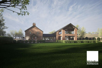
- Price
- £1,200,000
- Size
- 2 acres
Cinder Lane, Over Peover, WA16, Peover Superior and Snelson, Cheshire East WA16 England
Added on 09/04/2026Redevelopment Land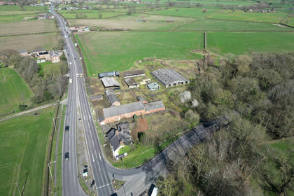
- Price
- Offers in Excess of£1,500,000
- Size
- 3.4 acres
Villa Farm, Chester Road, Tabley, WA16, Mere, Cheshire East WA16 England
Added on 10/09/2026Development Land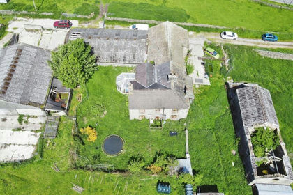
- Price
- Offers in Region of£1,400,000
- Size
- 5 acres
Birch Vale, High Peak, Derbyshire, SK22, New Mills, Derbyshire SK22 England
Added on 26/06/2026Development Land