Hatton Hall, Hatton. Derbyshire. DE65
- Land size
- 6.4 acres
- Bedrooms
- 6
- Bathrooms
- 3
Key Features
- Quote Reference - #RD31
- 6.4 Acres with an Option to Purchase an Additional 7 Acres of a Neighbouring Field.
- 6 Bed 3 Bathroom Georgian Residence with 5 Reception Rooms
- Major Redevelopment Required
- 2 Bed Cottage, 1 Bed Annex and 14 Bed Annex
- First Time to the Open Market in Over 50 years
- Tree Lined Gated Driveway
- 8 Stables, Tack Room and Barn
- Tennis Court
- EPC Rating E, Council Tax Band G, Freehold
Description
Hatton Hall is an impressive Georgian residence offering a rare opportunity to acquire a substantial country property with extensive accommodation, grounds and outbuildings. Requiring modernisation, subject to planning permission (STPP), the estate presents exceptional scope to create a remarkable 21st-century country home while retaining the character and presence of this distinguished period property.
The main house provides generous and versatile accommodation, comprising six bedrooms, three bathrooms and five reception rooms, with the scale and proportions expected of a property of this stature.
Beyond the principal residence is an exceptional range of additional accommodation. This includes a 12-bedroom, four-bathroom single-storey annexe, a two-bedroom open-plan cottage and a further one-bedroom ground-floor annexe. Collectively, the buildings provide over 1,000 sqm/10821 sqft of space, creating considerable flexibility for multi-generational living, guest accommodation or other uses, (STPP).
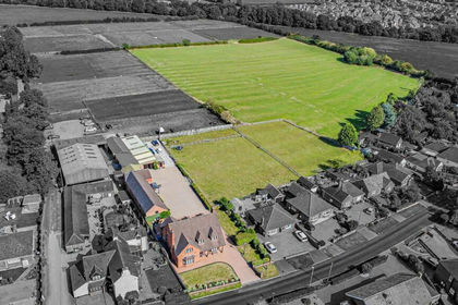
The estate is set within approximately 6.4 acres, with further land potentially available by separate negotiation. The grounds are complemented by a tennis court, eight stables, additional storage and a barn, making Hatton Hall particularly appealing to buyers seeking space, privacy and equestrian facilities.
While the property requires significant updating and renovation (STPP), this is central to its appeal: an opportunity for a purchaser to reimagine an extensive Georgian estate to their own specification. The combination of the principal house, separate accommodation, substantial outbuildings and extensive grounds provides considerable potential for a variety of future uses, subject to planning and all necessary approvals.
Secure Sale & Buyer Information Pack Disclosure
This property is being marketed with a Secure Sale Pack, designed to help speed up the transaction and provide greater certainty for both buyers and sellers.
As part of this process, key legal searches are ordered at the point the property is listed, rather than after a sale is agreed. This work, which can typically take several weeks in a standard transaction, is prepared upfront and made available to the successful buyer as part of their legal due diligence.
To proceed with an offer, the successful buyer will be required to purchase the Buyer Information Pack at a cost of £325 + VAT. This pack includes the searches and supporting legal information that a buyer would usually need to obtain separately after agreeing a purchase.
In addition, and in line with UK Anti-Money Laundering regulations, all purchasers and any giftors contributing funds must complete AML (Anti-Money Laundering) checks. These checks are payable separately and are required before the transaction can progress.
This upfront approach helps:
* Reduce delays once an offer is agreed
* Improve transparency for all parties
* Support a smoother and more reliable sales process
Disclaimer Statement:
These property particulars are issued in good faith but do not form part of any offer or contract. All descriptions, floorplans, photographs and other information are provided as a guide only and may not be exact. Buyers are advised to verify key facts such as tenure, planning permissions, fixtures and fittings, lease length, ground rent, service charges, council tax band and energy performance rating through their legal representative.
Where applicable, this property is marketed with a Secure Sale Pack, designed to support a faster and more transparent transaction. The successful buyer will be required to purchase the Buyer Information Pack at a cost of £325 + VAT (£390 including VAT) in order to proceed with their offer. This pack includes key searches and supporting legal information that would ordinarily be obtained by a buyer after a sale is agreed.
In line with UK Anti-Money Laundering regulations, all named purchasers and any giftors contributing funds must complete AML (Anti-Money Laundering) checks.
The cost of AML checks is £20 + VAT per person (£24 including VAT) and is payable separately. All required AML checks must be completed before the transaction can progress.
We have taken all reasonable steps to ensure the accuracy of this information. Material information is provided in line with current National Trading Standards guidance and relevant consumer protection legislation. Please contact us if you require clarification on any point before making a transactional decision.
Map Location
Property details
- Tenure
- Freehold
- Council Tax Band
- G
- Date Posted
- 2026-08-24
Market Value Analysis
Compared with 166 Homes with Land listings in East Midlands (5+ acres).
Energy Performance Certificate
Energy Efficiency Rating
Based on UK Energy Performance Certificate standards (EU Directive 2002/91/EC)
Running costs are one side. Planning activity, flood history and ground risks for this location are in the full report.
Utilities & Restrictions
Utilities
- Electricity
- Mains
- Water
- Mains
- Heating
- Gas Heating
- Broadband
- Fibre (FTTC)
- Sewerage
- Mains
Rights & Restrictions
- Public Rights of Way
- Ask Agent
- Private Rights of Way
- Ask Agent
- Listed Property
- Ask Agent
- Restrictions
- Ask Agent
Listed status, conservation areas and planning constraints for this location are in the full report.
Property Features
- Accessibility
- Ask Agent
- Parking
- Gated Parking
- Garden
- Enclosed Garden
Beyond the particulars: planning activity, flood history, heritage and ground risks, checked for this exact spot.
Connectivity
Broadband
Fastest speed available at this postcode
2.3 Gbps
Gigabit full fibre · available to 68% of premises
Suitable for
- 4K streaming on every screen
- Full-time home working
- Online gaming & big downloads
Mobile signal
Predicted 4G and 5G signal; indoor signal depends on building materials.
Ofcom Connected Nations postcode-level predictions. Speeds and signal are modelled, not measured, and vary between addresses and providers.
Signal is the easy part. Planning activity, flood history and protected designations here are in the full report.
Nearest Schools
Primary
- Heath Fields Primary School973 metresOfsted: Good
- Ages
- 4 to 11
- Pupils
- 185
- Type
- Community school
- Richard Wakefield CofE Primary Academy1.4 milesOfsted: Good
- Ages
- 3 to 11
- Pupils
- 255
- Type
- Academy converter
- Faith
- Church of England
- Church Broughton CofE Primary School1.8 milesNo Ofsted rating
- Ages
- 4 to 11
- Pupils
- 68
- Type
- Voluntary controlled school
- Faith
- Church of England
- Hilton Spencer Academy1.9 milesNo Ofsted rating
- Ages
- 3 to 11
- Pupils
- 548
- Type
- Academy converter
- The Mease Spencer Academy2.2 milesOfsted: Good
- Ages
- 4 to 11
- Pupils
- 202
- Type
- Free schools
Secondary
- John Port Spencer Academy3.1 milesOfsted: Good
- Ages
- 11 to 18
- Pupils
- 2,034
- Type
- Academy sponsor led
- The de Ferrers Academy3.5 milesOfsted: Good
- Ages
- 11 to 18
- Pupils
- 2,403
- Type
- Academy converter
- Abbot Beyne School5.4 milesNo Ofsted rating
- Ages
- 11 to 18
- Pupils
- 834
- Type
- Voluntary controlled school
- John Taylor Free School5.8 milesOfsted: Good
- Ages
- 11 to 19
- Pupils
- 1,315
- Type
- Free schools
- Paget High School6.2 milesOfsted: Good
- Ages
- 11 to 18
- Pupils
- 606
- Type
- Community school
Distances are straight-line from the advertised location. Source: the national school registers (DfE, Welsh Government, Scottish Government) and Ofsted.
Schools are just the start: sold prices nearby, planning activity and any flood history are in the full report.
Amenities
Supermarket
GP surgery
Pharmacy
Hospital
Green space
Straight-line distances from the advertised location. Sources: NHS records, Geolytix supermarket locations, OS Open Greenspace and the national trails registers.
The area stacks up? Now check the location itself: planning nearby, protected designations and past flooding.
Getting Around
Nearest station
Nearest bus stop
Typical drive times
Straight-line distances from the advertised location; drive times are typical free-flow times over OpenStreetMap road data, so allow more at peak. Public transport locations from DfT NaPTAN.
Easy to reach matters. So do planning activity, flood history and ground risks: all in the full report.
Flood Risk
Environment Agency open data, checked around the advertised map pin for the listed acreage. Long-term risk counts flood defences; the planning map's flood zones do not. Provided by LandSale, not the listing agent, and not part of the agent's particulars. Risk varies across a holding, so verify before committing.
Rivers and the sea
Not at the pin: mapped about 10 metres away.
Planning map: Flood Zone 3, about 70 metres away.
Surface water
Not at the pin: mapped about 30 metres away.
These bandings are the summary. Where this location sits on the flood maps, plus planning activity, heritage and ground risks, is in the full report.
Important notice: Information, maps and tags on this page are drawn from the advertising agent's marketing materials or generated automatically. LandSale has not verified them. Relying on these details is at your own risk, always carry out independent checks before committing to a purchase.
LandSale full disclaimer
Marketing information only - not formal particulars. The details on this website are provided for general guidance and do not constitute an offer or contract. Neither LandSale nor the advertising estate/land agent accepts responsibility for any inaccuracy.
1. Source of information
- Listing content: Core description, asking price, tenure, measurements, photographs and planning history originate from the marketing materials of the advertising estate or land agent. LandSale does not author this content and cannot guarantee its accuracy.
- Automated tags & categorisation: Property type, land-use class, acreage bands and similar labels may be applied by machine-learning models. They are intended as a helpful guide only and may not reflect the property's legal status or permitted use.
- Third-party & enriched data layers: Maps, boundary outlines, planning designations, soil reports, broadband coverage and other environmental or location-based insights are licensed from external suppliers. Such data are supplied “as is", may be incomplete or out of date and are subject to change without notice.
2. Verification required
Prospective purchasers must verify critical matters, including but not limited to planning permission, title boundaries, public rights of way, environmental constraints, acreage, services, access and VAT status, through their own inspections, specialist surveys, legal advisers and the selling agent before relying on the information or entering into any contract.
3. No warranty or liability
LandSale gives no warranty, express or implied, as to the accuracy, completeness or fitness for any particular purpose of the information displayed. LandSale shall not be liable for any loss, damage, cost or expense arising directly or indirectly from any use of or reliance on such information, save where liability may not be excluded by law.
4. Updates & feedback
If you believe any detail on this listing is inaccurate, please let us know. We will investigate and, where appropriate, update the listing or notify the agent.
© LandSale | Version 1.3 - August 2026
Listing agent
The Avenue, Covering National
Office 5, 10 Burnett Road, Sutton Coldfield, B74 3LP
Contact The Avenue, Covering National
Office 5, 10 Burnett Road, Sutton Coldfield, B74 3LP
View agent profileSimilar properties for sale
- Price
- £1,125,000
- Size
- 10 acres
Craythorne Road, Stretton, Burton-On-Trent, Stretton, Staffordshire DE13 England
Added on 28/01/2026House with Land
- Price
- Guide Price£1,125,000
- Size
- 4.25 acres
The Pump House, New Gate Court, Main Road, Anslow, DE13, Anslow, Staffordshire DE13 England
Added on 04/08/2026Barn Conversion
- Price
- Guide Price£1,250,000
- Size
- 9.1 acres
Greenways, Church Road, Egginton, DE65, Egginton, Derbyshire DE65 England
Added on 30/07/2026House with Land
- Price
- £1,200,000
- Size
- 4 acres
The Lodge, Main Street, Burnaston, Derby, Burnaston, Derbyshire DE65 England
Added on 31/07/2026House with Land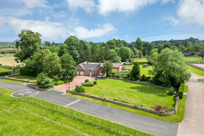
- Price
- Guide Price£1,790,000
- Size
- 19.58 acres
Newton Solney, Derbyshire, Newton Solney, Derbyshire DE15 England
Added on 30/07/2026House with Land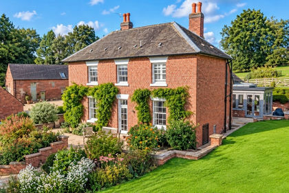
- Price
- Offers in Excess of£1,750,000
- Size
- 3.48 acres
Culland Manor Farm, Long Lane, Ashbourne, Derbyshire, Brailsford, Derbyshire DE6 England
Added on 18/09/2026Farmhouse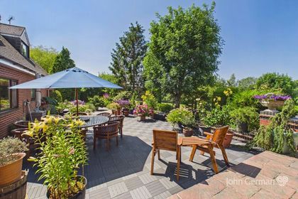
- Price
- £1,350,000
- Size
- 9.74 acres
Added on 23/07/2026House with Land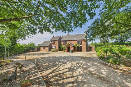
- Price
- £1,295,000
- Size
- 7.2 acres
Greysich Lane, Bretby, Burton On Trent, Bretby, Derbyshire DE15 England
Added on 24/07/2026House with Land
- Price
- £1,250,000
- Size
- 7.3 acres
Added on 29/01/2026House with Land
- Price
- Offers in Excess of£1,295,000
- Size
- 4.3 acres
Fairview, Upper Hoar Cross Road, Hadley End, DE13, Yoxall, Staffordshire DE13 England
Added on 29/01/2026Equestrian property