The Byre House and Cottage, Fearby, North Yorkshire
- Bedrooms
- 4
- Bathrooms
- 3
Key Features
- Separate 2 bedroom cottage.
- High sough after village.
- Local pub.
- 4 double bedrooms.
- 50' open plan living space.
- Stunning views.
- delightful garden.
- No onward chain.
Description
An exceptional and highly desirable 19th Century barn conversion with commanding, far reaching views with 4 bedrooms and a separate 2 bedroom cottage. No onward chain.
Masham 2 miles, Ripon 12 miles, Harrogate 21 miles, A1 11 ½ miles, Northallerton Train Station 16 miles.
The Byre House is situated in the middle of this highly desirable village with a separate 2 bedroom cottage and wonderful views at the rear. The house has great open plan reception space and bags of character. There is ample parking and a useful garage.
Path leads to the front door and leads straight into the sun room. From here you enter the kitchen area with a good array of base and eyelevel units and a mixture of wood and granite work tops with Belfast sink, a recently installed Rangemaster all electric induction hob range cooker and a dishwasher.
There is a double store cupboard, an understairs cupboard and a Log burner on a stone hearth with a recessed log store to one side. Arch leads through a spectacular open plan room of over 50? with a
dining area with views over the field to the side of the house. A further arch leads to the sitting area with triple aspect and French doors to the outside terrace and garden. The ceiling is open to the beams and creates a great feeling of space. There is an open fireplace with stone mantle and surrounds with a stone hearth and large Jotul log burner. From the kitchen there are steps to the laundry room with a Butlers sink with a washing machine and tumble dryer installed below and a cupboard housing the hot water tank. Further door leads to the garage. The house has a large capacity Air Source Heat Pump installed that provides the domestic hot water and central heating for the house. The whole of the downstairs has underfloor heating with conventional radiators to the first floor.
First floor:- landing area with linen cupboard and access via a hatch to the roof space. Bedroom 1 has a double aspect with far reaching views and is open to the ceiling with wooden beams. There is an en-suite bathroom with a panel enclosed bath with a separate wall mounted shower and glass screen, wash handbasin set in a vanity unit with a granite top and cupboard below, low level WC, wall mounted heated towel rail, wall shaver socket and a second door leading to the landing. Bedroom 2 is double aspect with great views, beamed open ceiling, dressing/sitting area and 2 sets of built-in wardrobes. En-suite shower room with shower cubicle, wash handbasin set in a vanity unit with cupboard and drawers below, mirror and light above, low level WC and wall mounted heated towel rail. Bedroom 3 has a study area with built-in desk and shelves and steps up to the bedroom area. Bedroom 4 with feature wooden beam. All the bedrooms have great views.
Outside.
Large yard between the house and Church View Cottage with space to park several
vehicles. The gardens are a delight and have several different aspects to them with well stocked borders, mature planting and soft fruit trees as well as raspberries and currant bushes. There is a raised vegetable area and a main paved dining area situated just off the sitting room as well as further paved areas for relaxation and a designated BBQ area with a stone store. There are a couple of wooden log stores and a substantial wooden work shed. The views from the garden are stunning and South facing with a clear 35 mile vista on a clear day up to the Yorkshire Moors, Sutton Bank and The White Horse as well as over the valley and up to Swinton Woods. Across the yard stands Church View Cottage.
Church View Cottage.
This is a stone built single storey farm building converted into a separate cottage, with a large sitting/dining room, fully fitted kitchen, two bedrooms and a bathroom with shower. Outside it has a small secure enclosed garden with a paved area and lawn, with the same stunning views as The Byre House.
From a separate outside door via stairs there is access to a large loft storage room above.
Over recent years it has been successfully let out as a furnished holiday let but could equally serve as a granny annexe.
Location:-
The Byre House is situated in the middle of the village with great views. Situated in the Nidderdale area of outstanding natural beauty, Fearby is a picturesque Village with a beautiful village Green and has a good local pub, The Black Swan, in the heart of the village as well as a Village Hall. There is a great feeling of community in this village and it is a very popular spot. The Market town of Masham is close by and has a good range of local shops to provide for everyday needs as well as a number of good pubs, restaurants, garage, 2 Breweries, an excellent primary and pre-school and an outstanding Doctors surgery! There is a range of first rate senior schools in the local area both private and public with bus services to most. The A1 is just over 7 miles away allowing for access to the major towns and businesses of the North East. The railway station at Northallerton is approximately 14 miles away and provides excellent access to the National Rail Network with direct links to London Kings Cross and Edinburgh. The racecourses of Ripon, Thirsk, Catterick and York are all within easy distance. The countryside around Fearby offers delightful riding and walking opportunities and has many local attractions with a charming local golf course and the highly renowned Swinton Park Luxury Castle Hotel with its Spa is close by.
Services:-
Mains water, electricity and drainage.
Council Tax.
Council tax is band ?F? and payable to Yorkshire Council.
Tenure and Possession.
The property is offered for sale freehold and with vacant possession upon completion.
EPC for the main house is a "C"..
Directions:-
Leave Masham on the Leyburn road and before you leave the town turn left to Fearby and Healey. Carry on this road, through Fearby Cross and entre Fearby. Carry on through the village and past the Green and The Byre House will be found on the left a couple of houses down from the pub.
Viewing:-
Strictly by prior appointment through Giles Edwards Yorkshire
Property Ltd, Tel: .
Map Location
Property details
- Tenure
- Freehold
- Council Tax Band
- F
- Date Posted
- 2026-08-22
Energy Performance Certificate
View the official EPC certificate for detailed energy efficiency information.
View official EPC certificate ↗
Running costs are one side. Planning activity, flood history and ground risks for this location are in the full report.
Utilities & Restrictions
Utilities
- Electricity
- Mains
- Water
- Mains
- Heating
- Double Glazing, Air Source Heat Pump, Underfloor Heating, Wood Burner
- Broadband
- Full Fibre (FTTP)
- Sewerage
- Mains
Rights & Restrictions
- Public Rights of Way
- Ask Agent
- Private Rights of Way
- Ask Agent
- Listed Property
- Ask Agent
- Restrictions
- Ask Agent
Listed status, conservation areas and planning constraints for this location are in the full report.
Property Features
- Accessibility
- Ask Agent
- Parking
- Garage, Secure Parking, Driveway, Off-Street Parking, Gated Parking, Private Parking
- Garden
- Private Garden, Enclosed Garden, Rear Garden, Rear Garden
Beyond the particulars: planning activity, flood history, heritage and ground risks, checked for this exact spot.
Connectivity
Broadband
Fastest speed available at this postcode
1.8 Gbps
Gigabit full fibre · available to 37% of premises
Suitable for
- 4K streaming on every screen
- Full-time home working
- Online gaming & big downloads
Fixed wireless access may also be an option here.
Mobile signal
Predicted 4G and 5G signal; indoor signal depends on building materials.
Ofcom Connected Nations postcode-level predictions. Speeds and signal are modelled, not measured, and vary between addresses and providers.
Signal is the easy part. Planning activity, flood history and protected designations here are in the full report.
Nearest Schools
Primary
- Masham CofE Primary School2.1 milesOfsted: Inadequate
- Ages
- 4 to 11
- Type
- Academy sponsor led
- Faith
- Church of England
- Grewelthorpe Church of England Primary School3.7 milesNo Ofsted rating
- Ages
- 3 to 11
- Pupils
- 63
- Type
- Academy converter
- Faith
- Church of England
- Thornton Watlass Church of England Primary School3.8 milesOfsted: Good
- Ages
- 3 to 11
- Pupils
- 13
- Type
- Voluntary controlled school
- Faith
- Church of England
- Kirkby Malzeard Church of England Primary School4.8 milesNo Ofsted rating
- Ages
- 5 to 11
- Pupils
- 96
- Type
- Voluntary controlled school
- Faith
- Church of England
- St Nicholas Church of England Primary School, West Tanfield4.8 milesNo Ofsted rating
- Ages
- 3 to 11
- Pupils
- 53
- Type
- Voluntary controlled school
- Faith
- Church of England
Secondary
- Bedale High School6.3 milesOfsted: Requires improvement
- Ages
- 11 to 16
- Pupils
- 555
- Type
- Community school
- Wensleydale School7.8 milesOfsted report card · May 2026
- Ages
- 11 to 16
- Pupils
- 407
- Type
- Community school
- Ripon Grammar School9 milesOfsted: Good
- Ages
- 11 to 18
- Pupils
- 957
- Type
- Community school
- Outwood Academy Ripon9.1 milesOfsted: Good
- Ages
- 11 to 18
- Pupils
- 609
- Type
- Academy converter
- Nidderdale High School9.6 milesOfsted report card · Apr 2026
- Ages
- 11 to 16
- Pupils
- 404
- Type
- Academy converter
Distances are straight-line from the advertised location. Source: the national school registers (DfE, Welsh Government, Scottish Government) and Ofsted.
Schools are just the start: sold prices nearby, planning activity and any flood history are in the full report.
Amenities
Supermarket
GP surgery
Pharmacy
Hospital
Straight-line distances from the advertised location. Sources: NHS records, Geolytix supermarket locations, OS Open Greenspace and the national trails registers.
The area stacks up? Now check the location itself: planning nearby, protected designations and past flooding.
Getting Around
Nearest station
Nearest bus stop
Typical drive times
Straight-line distances from the advertised location; drive times are typical free-flow times over OpenStreetMap road data, so allow more at peak. Public transport locations from DfT NaPTAN.
Easy to reach matters. So do planning activity, flood history and ground risks: all in the full report.
Flood Risk
Environment Agency open data, checked around the advertised map pin for the listed acreage. Long-term risk counts flood defences; the planning map's flood zones do not. Provided by LandSale, not the listing agent, and not part of the agent's particulars. Risk varies across a holding, so verify before committing.
Rivers and the sea
Planning map: Flood Zone 1.
Surface water
Not at the pin: mapped about 10 metres away.
These bandings are the summary. Where this location sits on the flood maps, plus planning activity, heritage and ground risks, is in the full report.
Important notice: Information, maps and tags on this page are drawn from the advertising agent's marketing materials or generated automatically. LandSale has not verified them. Relying on these details is at your own risk, always carry out independent checks before committing to a purchase.
LandSale full disclaimer
Marketing information only - not formal particulars. The details on this website are provided for general guidance and do not constitute an offer or contract. Neither LandSale nor the advertising estate/land agent accepts responsibility for any inaccuracy.
1. Source of information
- Listing content: Core description, asking price, tenure, measurements, photographs and planning history originate from the marketing materials of the advertising estate or land agent. LandSale does not author this content and cannot guarantee its accuracy.
- Automated tags & categorisation: Property type, land-use class, acreage bands and similar labels may be applied by machine-learning models. They are intended as a helpful guide only and may not reflect the property's legal status or permitted use.
- Third-party & enriched data layers: Maps, boundary outlines, planning designations, soil reports, broadband coverage and other environmental or location-based insights are licensed from external suppliers. Such data are supplied “as is", may be incomplete or out of date and are subject to change without notice.
2. Verification required
Prospective purchasers must verify critical matters, including but not limited to planning permission, title boundaries, public rights of way, environmental constraints, acreage, services, access and VAT status, through their own inspections, specialist surveys, legal advisers and the selling agent before relying on the information or entering into any contract.
3. No warranty or liability
LandSale gives no warranty, express or implied, as to the accuracy, completeness or fitness for any particular purpose of the information displayed. LandSale shall not be liable for any loss, damage, cost or expense arising directly or indirectly from any use of or reliance on such information, save where liability may not be excluded by law.
4. Updates & feedback
If you believe any detail on this listing is inaccurate, please let us know. We will investigate and, where appropriate, update the listing or notify the agent.
© LandSale | Version 1.3 - August 2026
Listing agent
Giles Edwards Yorkshire Property, Masham
4 Market Place, Masham, HG4 4EB
Similar properties for sale
- Price
- Guide Price£895,000
- Size
- 2 acres
The Blacksmith, Fearby, Masham, Fearby, North Yorkshire HG4 England
Added on 29/01/2026House with Land
- Price
- Offers in Excess of£895,000
- Size
- 2 acres
Added on 29/01/2026House with Land
- Price
- Guide Price£967,000
- Size
- 2 acres
Holly Tree Farm, Fearby, Ripon, HG4, Fearby, North Yorkshire HG4 England
Added on 16/04/2026House with Land
- Price
- Offers Over£895,000
Fairfield Barn, Back Lane, Kirkby Malzeard, Ripon, Kirkby Malzeard, North Yorkshire HG4 England
Added on 30/03/2026Barn Conversion
- Price
- Guide Price£700,000
- Size
- 8 acres
Dog Hill Barn, Middleham, Middleham, North Yorkshire DL8 England
Added on 03/09/2026House with Land
- Price
- Guide Price£1,100,000
- Size
- 1.5 acres
Added on 30/05/2026Country Home
- Price
- Guide Price£1,100,000
- Size
- 1.97 acres
Added on 26/08/2026Development Land
- Price
- Guide Price£800,000
- Size
- 1.94 acres
The Gill, Harmby, Leyburn, Harmby, North Yorkshire DL8 England
Added on 18/08/2026House with Land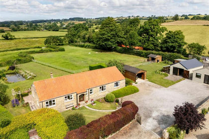
- Price
- Guide Price£800,000
- Size
- 1.43 acres
Green Pastures, Hunton, Bedale, North Yorkshire DL8, Hunton, North Yorkshire DL8 England
Added on 12/07/2026House with Land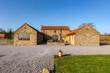
- Price
- Offers in Region of£900,000
- Size
- 4.44 acres
Added on 15/03/2026Barn Conversion