Barnsley Road, Rotherham, S61
- Bedrooms
- 3
- Bathrooms
- 1
Key Features
- Established Equestrian Yard And Stables
- Approximately Thirty Acres Of Leased Land
- Two Distinctive Courtyard Settings
- Collection Of Original Stone Barns
- Substantial Two-Storey Traditional Barn
- Further Conversion Potential Subject To Planning
- Peaceful Semi-Rural Village Setting
- Accessible Sheffield And Rotherham Location
- Rare Lifestyle And Development Opportunity
Description
Exclusively with MSRE Global - Barley Hall Stables | A Rare Equestrian Lifestyle And Development Opportunity
Hidden beyond a shared country lane in the village of Thorpe Hesley, Barley Hall Stables is a rare rural property where equestrian life, historic character and future possibility come together within a distinctive courtyard setting.
Currently operating as a stable yard, the property centres around an attractive three-bedroom converted barn extending to approximately 1500 sq. ft. Beyond the existing home lies a fascinating collection of original stone barns, modern stables, ancillary buildings and two courtyards, creating an opportunity that will appeal equally to committed equestrians and purchasers with a vision for something more ambitious.
The experience begins along the shared driveway, where the surrounding landscape gradually gives way to the first courtyard. Here, traditional stone buildings sit alongside practical stable accommodation, immediately revealing the property’s equestrian identity.
The courtyard includes a substantial two-storey barn, contemporary breeze-block stables and a separate tack room, providing essential facilities for the organisation and daily operation of a private yard. The arrangement of the buildings creates an authentic sense of enclosure and atmosphere, reflecting the agricultural heritage of the setting.
Continuing through the property, a second courtyard provides a more private environment around the main residence.
The beautifully converted barn offers approximately 1500 sq. ft. of characterful and versatile accommodation, with three bedrooms and the warmth expected from a home shaped from a traditional rural building. Its position within the rear courtyard allows the residence to feel connected to the wider equestrian setting while retaining a welcome degree of separation from the working areas.
Further buildings include an additional barn and former cow barn, each contributing to the extraordinary versatility of the site.
Subject to the relevant planning permissions, listed-building considerations where applicable, structural investigations and professional advice, these buildings may present opportunities for conversion, ancillary accommodation or the creation of a broader multi-generational family setting.
The potential lies not simply in adding more living space, but in imagining how the collection of buildings might work together: a principal residence accompanied by accommodation for extended family, private offices, leisure facilities, studios or equestrian support spaces.
For horse owners, Barley Hall Stables offers the foundations of an established rural lifestyle. The existing stables, tack room, barns and courtyard arrangement support the practical demands of keeping horses, while approximately 30 acres of land are currently leased from the Wentworth Estate for riding, grazing and related use.
Prospective purchasers should note that the approximately 30 acres are leased rather than included within the freehold sale. The terms, availability, continuation and potential transfer of any lease or occupational arrangement must be confirmed through the seller, the Wentworth Estate and the purchaser’s legal advisers.
Beyond its equestrian credentials, the property offers something more emotional: the opportunity to wake within a historic rural environment, to live close to the land and to shape a home around family, animals and a more independent way of life.
The two courtyards provide natural structure to the setting. One can remain focused on equestrian and operational requirements, while the second forms a quieter residential heart around the converted barn. This distinction creates compelling potential for buyers seeking separation between home life and outdoor pursuits.
Situated in Thorpe Hesley, Barley Hall Stables enjoys a semi-rural South Yorkshire setting while remaining accessible to Rotherham, Sheffield and the surrounding motorway network. It offers a rare balance between countryside atmosphere and proximity to the region’s principal towns and cities.
Whether retained as an established equestrian property or sensitively evolved into a wider family compound, subject to all necessary permissions, Barley Hall Stables represents an opportunity defined by character, scale and imagination.
Contact MSRE Global to arrange your private viewing of Barley Hall Stables, a remarkable courtyard property where equestrian heritage, rural living and the potential to create something truly individual come together.
Map Location
Property details
- Tenure
- Freehold
- Council Tax Band
- Ask Agent
- Date Posted
- 2026-08-01
Energy Performance Certificate
Energy Efficiency Rating
Based on UK Energy Performance Certificate standards (EU Directive 2002/91/EC)
Running costs are one side. Planning activity, flood history and ground risks for this location are in the full report.
Utilities & Restrictions
Utilities
- Electricity
- Ask Agent
- Water
- Ask Agent
- Heating
- Ask Agent
- Broadband
- Ask Agent
- Sewerage
- Ask Agent
Rights & Restrictions
- Public Rights of Way
- Ask Agent
- Private Rights of Way
- Ask Agent
- Listed Property
- Ask Agent
- Restrictions
- Ask Agent
Listed status, conservation areas and planning constraints for this location are in the full report.
Property Features
- Accessibility
- Ask Agent
- Parking
- Parking Available
- Garden
- Garden
Beyond the particulars: planning activity, flood history, heritage and ground risks, checked for this exact spot.
Connectivity
Broadband
Fastest speed available at this postcode
30 Mbps
Superfast
Suitable for
- HD streaming
- Video calls
- Web & social
Mobile signal
Outdoor predictions; indoor signal depends on building materials.
Ofcom Connected Nations postcode-level predictions. Speeds and signal are modelled, not measured, and vary between addresses and providers.
Signal is the easy part. Planning activity, flood history and protected designations here are in the full report.
Nearest Schools
Primary
- Wentworth CofE Junior and Infant School0.9 milesNo Ofsted rating
- Ages
- 5 to 11
- Pupils
- 105
- Type
- Academy converter
- Faith
- Church of England
- Thorpe Hesley Primary School0.9 milesNo Ofsted rating
- Ages
- 2 to 11
- Pupils
- 580
- Type
- Academy converter
- Lound Junior School1.3 milesNo Ofsted rating
- Ages
- 7 to 11
- Pupils
- 195
- Type
- Academy converter
- Lound Infant School1.6 milesNo Ofsted rating
- Ages
- 4 to 7
- Pupils
- 142
- Type
- Academy converter
- Coit Primary School1.6 milesOfsted: Good
- Ages
- 4 to 11
- Pupils
- 203
- Type
- Community school
Secondary
- Ecclesfield School1.6 milesOfsted: Good
- Ages
- 11 to 16
- Pupils
- 1,711
- Type
- Academy sponsor led
- Kirk Balk Academy2.2 milesOfsted: Good
- Ages
- 11 to 16
- Pupils
- 1,318
- Type
- Academy sponsor led
- Wingfield Academy2.8 milesOfsted report card · Jun 2026
- Ages
- 11 to 16
- Pupils
- 990
- Type
- Academy converter
- Winterhill School3 milesNo Ofsted rating
- Ages
- 11 to 16
- Pupils
- 941
- Type
- Academy converter
- Lift Firth Park3.1 milesOfsted: Requires improvement *
- Ages
- 11 to 16
- Pupils
- 1,115
- Type
- Academy sponsor led
* Latest graded judgement covers quality of education only; no overall grade was issued under the 2024-25 inspection framework.
Distances are straight-line from the advertised location. Source: the national school registers (DfE, Welsh Government, Scottish Government) and Ofsted.
Schools are just the start: sold prices nearby, planning activity and any flood history are in the full report.
Amenities
Supermarket
GP surgery
Pharmacy
Hospital
Green space
Straight-line distances from the advertised location. Sources: NHS records, Geolytix supermarket locations, OS Open Greenspace and the national trails registers.
The area stacks up? Now check the location itself: planning nearby, protected designations and past flooding.
Getting Around
Nearest station
Nearest bus stop
Typical drive times
Straight-line distances from the advertised location; drive times are typical free-flow times over OpenStreetMap road data, so allow more at peak. Public transport locations from DfT NaPTAN.
Easy to reach matters. So do planning activity, flood history and ground risks: all in the full report.
Flood Risk
From Environment Agency flood map open data, checked around the advertised map pin and allowing for the listed acreage where known. This summary comes from LandSale, the advertising platform, not from the listing agent, and is not part of the agent's particulars. Risk can vary across a single holding, so verify anything critical through your own searches before committing.
Rivers and the sea
Surface water
These bandings are the summary. Where this location sits on the flood maps, plus planning activity, heritage and ground risks, is in the full report.
Important notice: Information, maps and tags on this page are drawn from the advertising agent's marketing materials or generated automatically. LandSale has not verified them. Relying on these details is at your own risk, always carry out independent checks before committing to a purchase.
LandSale full disclaimer
Marketing information only - not formal particulars. The details on this website are provided for general guidance and do not constitute an offer or contract. Neither LandSale nor the advertising estate/land agent accepts responsibility for any inaccuracy.
1. Source of information
- Listing content: Core description, asking price, tenure, measurements, photographs and planning history originate from the marketing materials of the advertising estate or land agent. LandSale does not author this content and cannot guarantee its accuracy.
- Automated tags & categorisation: Property type, land-use class, acreage bands and similar labels may be applied by machine-learning models. They are intended as a helpful guide only and may not reflect the property's legal status or permitted use.
- Third-party & enriched data layers: Maps, boundary outlines, planning designations, soil reports, broadband coverage and other environmental or location-based insights are licensed from external suppliers. Such data are supplied “as is", may be incomplete or out of date and are subject to change without notice.
2. Verification required
Prospective purchasers must verify critical matters, including but not limited to planning permission, title boundaries, public rights of way, environmental constraints, acreage, services, access and VAT status, through their own inspections, specialist surveys, legal advisers and the selling agent before relying on the information or entering into any contract.
3. No warranty or liability
LandSale gives no warranty, express or implied, as to the accuracy, completeness or fitness for any particular purpose of the information displayed. LandSale shall not be liable for any loss, damage, cost or expense arising directly or indirectly from any use of or reliance on such information, save where liability may not be excluded by law.
4. Updates & feedback
If you believe any detail on this listing is inaccurate, please let us know. We will investigate and, where appropriate, update the listing or notify the agent.
© LandSale | Version 1.3 - August 2026
Listing agent
MSRE Global, Covering London
London
Similar properties for sale
- Price
- Offers in Region of£1,250,000
- Size
- 2.5 acres
Bell Ground House and Cottage, Sheffield Road, Hoyland, S74, Tankersley, Barnsley S74 England
Added on 29/01/2026Farmhouse
- Price
- Guide Price£950,000
- Size
- 2 acres
241 Burncross Road, Chapeltown, Sheffield, South Yorkshire S35, Ecclesfield, Sheffield S35 England
Added on 09/07/2026Development Land
- Price
- Offers in Region of£950,000
- Size
- 1 acres
Kingwell Road, Worsbrough, S70, Barnsley South, Barnsley S70 England
Added on 28/01/2026House with Land
- Price
- Offers in Excess of£800,000
Added on 10/06/2026Barn Conversion
- Price
- Offers in Excess of£950,000
- Size
- 4.7 acres
Green Moor, Wortley, Sheffield, Stocksbridge, Sheffield S36 England
Added on 30/05/2026House with Land
- Price
- £999,950
- Size
- 1 acres
Doncaster Road, Thrybergh, Rotherham, Thrybergh, Rotherham S65 England
Added on 09/09/2026Country Home
- Price
- Guide Price£1,250,000
- Size
- 2.5 acres
Hooton Roberts SOUTH YORKSHIRE, Hooton Roberts, Rotherham S65 England
Added on 11/06/2026Barn Conversion
- Price
- £900,000
- Size
- 5 acres
Cherry Tree Farm, Nethergate, Stannington, Bradfield, Sheffield S6 England
Added on 08/08/2026Barn Conversion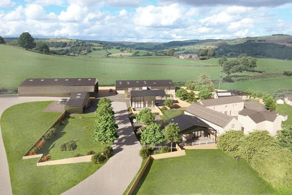
- Price
- Offers in Excess of£1,000,000
- Size
- 1 acres
Sykehouse Lane, Dungworth, Bradfield, Sheffield, Bradfield, Sheffield S6 England
Added on 26/06/2026Development Land
- Price
- Offers in Region of£850,000
- Size
- 11.7 acres
Barnsley Road, Hoylandswaine, Barnsley, S36, Penistone, Barnsley S36 England
Added on 13/08/2026Agricultural Land