Sykehouse Lane, Dungworth, Bradfield, Sheffield
- Land size
- 1 acres
Key Features
- An Exciting Residential Development Opportunity
- Planning Permission Granted for 11 Barn Conversions Across Multiple Applications
- Skilfully Designed to Create Beautiful, Functional Homes
- Mixture of Four, Three and Two Bedroomed Properties
- Proposed Barn Conversions with a Layering Totalling over 1,200 Sq.m
- Full Plot Totalling Just over an Acre
- Situated within a Former Dairy Farm, Creating a Charming Setting
- Located in an Elevated Position, Affording Panoramic Countryside Views
- Positioned on the Edge of the Peak District National Park
- Offering the Perfect Blend of Country and City Life, Due to Access to Conveniences and Scenic Rural Attractions
Description
Nestled on the edge of the Peak District National Park, Sykehouse Farm presents an exciting development opportunity. With planning permission granted across multiple applications for 11 barn conversions, this 1 acre site offers fantastic scope to bring an appealing residential scheme to life.
Full planning permissions and permitted development rights under Class Q enable the site to be transformed into 13 units, three of which are being retained by the current owners (Barn 1, Barn 3B and Barn 5 on the site plan). The scheme has been expertly designed by Nordbarn, an architectural practice specialising in barn conversions and farm diversification projects. Each property combines modern necessities with sympathetic materials that ensure cohesiveness with the former dairy farm and its surroundings. The proposed dwellings comprise a mixture of four, three and two bedroomed homes, each with open plan living spaces.
Sykehouse Farm occupies an elevated position, which affords the site and proposed homes panoramic countryside views. The development will have two entry points, which will serve the converted barns and existing farmhouse at the front of the site. Within a shared courtyard, each of the plots will have allocated parking spaces.
Bradfield is conveniently situated to offer a harmonious blend of country and city life, with everything that the Peak District has to offer within easy reach. From scenic nearby trails around Damflask and Agden Reservoirs, to visiting some of the National Parks most popular attractions, such as Hathersage, Chatsworth House, Ladybower Reservoir, Winnats Pass and Mam Tor. The A57 provides road links to Sheffield and Manchester and there is convenient access to the M1 for journeys to major cities. Locally, there are a range of public and independent schools, alongside two universities within Sheffield city centre. Bamford train station is nearby, providing rail links to Sheffield, Manchester Piccadilly and the following Peak District locations: Hathersage, Grindleford, Hope and Edale.
Full List Of Planning Applications -
Full details available on the Sheffield City Council Planning Portal.
Ref. No: 23/04008/Ful - Use of agricultural buildings as 5 no. dwellings with associated demolition, access improvements, works and landscaping
(approved 2nd July 2024)
Ref. No: 24/03421/Arpn - Alterations and change of use of agricultural barn (3A) to form 1no. dwellinghouse (Use Class C3)
(approved 10th February 2025)
Ref. No: 24/03424/Arpn - Alterations and change of use of agricultural barn (7) to form 1no. dwellinghouse (Use Class C3)
(approved 10th February 2025)
Ref. No: 24/03427/Arpn - Alterations and change of use of agricultural barn (2) to form 4no. dwellinghouses (Use Class C3) (Amended Description)
(approved 10th February 2025)
Ref. No: 25/02376/Dpn - Partial demolition of Barns 3, 5, 7 and Barn Group A
(approved 9th September 2025)
A planning application will shortly be submitted to vary Ref. No. 23/04008/FUL in respect of the drainage strategy and access for Barn 4.
Additional Details -
Tenure - Freehold
Council Tax Band - Not yet determined.
Services - Mains water is currently connected, however, the purchaser will need to install a new connection alongside development. The drainage plans have been approved by Sheffield City Council, but is subject to a variation. Three-phase electricity is installed currently, and a purchaser will be required to connect to a new supply for the purpose of development, which is to be installed by the sellers.
Rights Of Access/Shared Access - The site proposal outlines two access points, which are detailed on the site plan and will be shared amongst the relevant barns.
Covenants/Easements Or Wayleaves And Flood Risk - The property is sold subject to any covenants, wayleaves and easements noted in the title. The flood risk is very low.
Viewings - Strictly by appointment with one of our sales consultants.
Note - Whilst we aim to make these particulars as accurate as possible, please be aware that they have been composed for guidance purposes only. Therefore, the details within should not be relied on as being factually accurate and do not form part of an offer or contract. All measurements are approximate. None of the services, fittings or appliances (if any), heating installations, plumbing or electrical systems have been tested and therefore no warranty can be given as to their working ability. All photography is for illustration purposes only.
Map Location
Property details
- Tenure
- Freehold
- Council Tax Band
- Ask Agent
- Date Posted
- 2026-06-26
Market Value Analysis
Compared with 124 Development Land listings in Yorkshire and The Humber (1+ acres).
Utilities & Restrictions
Utilities
- Electricity
- Mains
- Water
- Mains
- Heating
- Ask Agent
- Broadband
- Ask Agent
- Sewerage
- Ask Agent
Rights & Restrictions
- Public Rights of Way
- Ask Agent
- Private Rights of Way
- Ask Agent
- Listed Property
- Ask Agent
- Restrictions
- Ask Agent
Listed status, conservation areas and planning constraints for this location are in the full report.
Property Features
- Accessibility
- Ask Agent
- Parking
- Parking Available
- Garden
- Ask Agent
Beyond the particulars: planning activity, flood history, heritage and ground risks, checked for this exact spot.
Connectivity
Broadband
Fastest speed available at this postcode
60 Mbps
Superfast
Suitable for
- HD streaming
- Video calls
- Web & social
Mobile signal
Predicted 4G and 5G signal; indoor signal depends on building materials.
Ofcom Connected Nations postcode-level predictions. Speeds and signal are modelled, not measured, and vary between addresses and providers.
Signal is the easy part. Planning activity, flood history and protected designations here are in the full report.
Nearest Schools
Primary
- Bradfield Dungworth Primary School617 metresNo Ofsted rating
- Ages
- 4 to 11
- Pupils
- 120
- Type
- Academy converter
- Nook Lane Junior School1.5 milesNo Ofsted rating
- Ages
- 7 to 11
- Pupils
- 252
- Type
- Academy converter
- Stannington Infant School1.6 milesOfsted: Outstanding
- Ages
- 5 to 7
- Pupils
- 179
- Type
- Academy converter
- Loxley Primary School2 milesOfsted: Outstanding *
- Ages
- 4 to 11
- Pupils
- 207
- Type
- Academy converter
- Shooter's Grove Primary School2.3 milesNo Ofsted rating
- Ages
- 3 to 11
- Type
- Academy converter
Secondary
- Bradfield Secondary School2.1 milesOfsted: Good *
- Ages
- 11 to 19
- Pupils
- 1,006
- Type
- Academy converter
- Forge Valley School & Sixth Form2.6 milesOfsted: Good
- Ages
- 11 to 19
- Pupils
- 1,494
- Type
- Academy sponsor led
- Tapton School & Sixth Form3.1 milesOfsted: Outstanding *
- Ages
- 11 to 18
- Pupils
- 1,747
- Type
- Academy converter
- Notre Dame High School3.3 milesOfsted: Good
- Ages
- 11 to 18
- Pupils
- 1,491
- Type
- Academy converter
- Faith
- Roman Catholic
- High Storrs School3.9 milesNo Ofsted rating
- Ages
- 11 to 18
- Pupils
- 1,706
- Type
- Academy converter
* Latest graded judgement covers quality of education only; no overall grade was issued under the 2024-25 inspection framework.
Distances are straight-line from the advertised location. Source: the national school registers (DfE, Welsh Government, Scottish Government) and Ofsted.
Schools are just the start: sold prices nearby, planning activity and any flood history are in the full report.
Amenities
Supermarket
GP surgery
Pharmacy
Hospital
Green space
Straight-line distances from the advertised location. Sources: NHS records, Geolytix supermarket locations, OS Open Greenspace and the national trails registers.
The area stacks up? Now check the location itself: planning nearby, protected designations and past flooding.
Getting Around
Nearest station
Nearest bus stop
Typical drive times
Straight-line distances from the advertised location; drive times are typical free-flow times over OpenStreetMap road data, so allow more at peak. Public transport locations from DfT NaPTAN.
Easy to reach matters. So do planning activity, flood history and ground risks: all in the full report.
Flood Risk
Environment Agency open data, checked around the advertised map pin for the listed acreage. Long-term risk counts flood defences; the planning map's flood zones do not. Provided by LandSale, not the listing agent, and not part of the agent's particulars. Risk varies across a holding, so verify before committing.
Rivers and the sea
Planning map: Flood Zone 1.
Surface water
These bandings are the summary. Where this location sits on the flood maps, plus planning activity, heritage and ground risks, is in the full report.
Important notice: Information, maps and tags on this page are drawn from the advertising agent's marketing materials or generated automatically. LandSale has not verified them. Relying on these details is at your own risk, always carry out independent checks before committing to a purchase.
LandSale full disclaimer
Marketing information only - not formal particulars. The details on this website are provided for general guidance and do not constitute an offer or contract. Neither LandSale nor the advertising estate/land agent accepts responsibility for any inaccuracy.
1. Source of information
- Listing content: Core description, asking price, tenure, measurements, photographs and planning history originate from the marketing materials of the advertising estate or land agent. LandSale does not author this content and cannot guarantee its accuracy.
- Automated tags & categorisation: Property type, land-use class, acreage bands and similar labels may be applied by machine-learning models. They are intended as a helpful guide only and may not reflect the property's legal status or permitted use.
- Third-party & enriched data layers: Maps, boundary outlines, planning designations, soil reports, broadband coverage and other environmental or location-based insights are licensed from external suppliers. Such data are supplied “as is", may be incomplete or out of date and are subject to change without notice.
2. Verification required
Prospective purchasers must verify critical matters, including but not limited to planning permission, title boundaries, public rights of way, environmental constraints, acreage, services, access and VAT status, through their own inspections, specialist surveys, legal advisers and the selling agent before relying on the information or entering into any contract.
3. No warranty or liability
LandSale gives no warranty, express or implied, as to the accuracy, completeness or fitness for any particular purpose of the information displayed. LandSale shall not be liable for any loss, damage, cost or expense arising directly or indirectly from any use of or reliance on such information, save where liability may not be excluded by law.
4. Updates & feedback
If you believe any detail on this listing is inaccurate, please let us know. We will investigate and, where appropriate, update the listing or notify the agent.
© LandSale | Version 1.3 - August 2026
Listing agent
Blenheim, Sheffield
Old Station Works Old Station Drive Sheffield S7 2PY
Similar properties for sale
- Price
- Guide Price£950,000
- Size
- 2 acres
241 Burncross Road, Chapeltown, Sheffield, South Yorkshire S35, Ecclesfield, Sheffield S35 England
Added on 09/07/2026Development Land
- Price
- £875,000
Added on 25/09/2026Building Plot
- Price
- Offers in Region of£1,195,000
- Size
- 0.7 acres
Sledgate Lane, Wickersley, Rotherham, Wickersley, Rotherham S66 England
Added on 30/09/2026Building Plot
- Price
- Guide Price£1,150,000
Brockwell Lane, Chesterfield, S40, Chesterfield, Derbyshire S40 England
Added on 24/07/2026Development Land
- Price
- £1,000,000
Added on 29/01/2026Development Land
- Price
- Guide Price£950,000
- Size
- 1.2 acres
Land to The South Of The Heath, Glossop, Derbyshire, SK13, High Peak, Derbyshire SK13 England
Added on 20/03/2026Development Land
- Price
- £1,250,000
- Size
- 1.54 acres
The Drill Hall, Derby Road, Clay Cross, East Midlands, Clay Cross, Derbyshire S45 England
Added on 29/01/2026Development Land
- Price
- Guide Price£750,000
- Size
- 12.48 acres
Added on 02/10/2026Development Land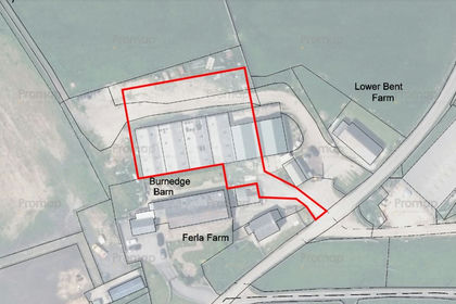 Added on 09/10/2026Building Plot
- Price
- Offers in Region of£1,000,000
Added on 03/09/2026Building Plot