Main Street, Mixbury, Brackley
- Land size
- 9.41 acres
Description
An exciting opportunity to acquire an attractive equestrian facility with stables, outbuildings, yard, and pastureland.
Extending to 9.41 acres (3.81 ha)
Situation - The property is situated within the Northamptonshire village of Mixbury, with access to the property via the public highway known as Main Street. The market town of Brackley is situated approximately 5 miles to the north, and provides an extensive range of local and amenity services, with the nearby market towns of Bicester and Towcester providing vast education and employment opportunities.
The nearby bridleways give access to a wide network of bridleways and paths around the surrounding villages.
The property is also in close proximity to several equestrian centres including Ouse Valley Liveries (5.5 miles), Foxhill Farm, Eydon (16 miles) and Aston Le Walls Equestrian Centre (18 miles).
Description - The property comprises a conveniently positioned equestrian facility, comprising a stable block, yard area, outbuildings, menage and paddock land, extending in all to approximately 9.41 acres (3.81 hectares). The property can be accessed from the public highway known as Main Street, with a private driveway off the highway giving access to the property.
The property benefits from an extensive range of traditional equestrian outbuildings extending to approximately 4,639 sq ft (430.9 sq m), offering well-planned facilities suitable for private or professional use (subject to planning).
The principal stable yard incorporates four internal loose boxes, each measuring approximately 15'1 x 10'3–10'9, together with a tack room and a substantial workshop (approximately 43'3 x 17'11), providing excellent storage and workspace space. Additionally there is a traditional barn (approximately 55'2 x 18'10) which adjoins four secure store rooms and an additional loose box, offering flexibility for hay, feed, machinery or general storage.
A further detached stable block provides four additional loose boxes, creating a total of nine stables across the holding. The arrangement of the buildings lends itself to efficient day-to-day yard management while allowing for the separation of horses where required. The stables are understood to benefit from a spring fed water supply and mains electricity supply, which also supplies the paddock land. Situated to the rear of the property is a 60m x 20m all-weather menage.
The land is presented as four main parcels of permanent pasture, which are then internally separated, and can all be accessed from the main yard. The land extends to approximately 8.26 acres and benefits from a mixture of mature hedgerow and tree boundaries together with stock fencing in varying conditions throughout.
The land is shown edged red on the site plan.
Services - The property is understood to be connected to a spring fed water supply servicing the fields and stables, as well as a mains electricity supply to the buildings.
Purchasers should make their own enquiries regarding the location of mains service supplies.
Easements, Wayleaves And Rights Of Way - The property can be accessed via a driveway off the public highway known as Main Street, with a gateway providing access to the property. The property is crossed by several public rights of way as shown on the sales plan.
The land is sold subject to and with the benefit of all other easements, wayleaves and rights of way that may exist at the time of the sale whether disclosed or not.
Tenure & Possession - The land will be sold freehold with vacant possession given on completion
Development Overage - The property is sold with a historic development overage of 50% for 80 years from the date of acquisition being 1994, and will therefore remain in place until 2074. The wording states that in the event of planning permission being obtained for the erection of one or more private dwellinghouses or the conversion of the existing building on the land they will pay to the vendor within 12 months of each such grant, or if a purchaser shall dispose of any part of the land to which planning permission relates a sum equivalent to 50% of the open market value of the land to which each permission relates. For further details, please speak to the vendors Agent.
Planning - It is the responsibility of the purchaser to make their own enquiries as to the planning history of the property.
Anti Money Laundering Regulations - Under the money laundering directive (S12017/692) we are required under due diligence as set up under HMRC to take full identification (e.g. photo ID and recent utility bill as proof of address). When a potential purchaser submits an offer for a property, please be aware of this and have the information available.
Fixtures & Fittings - Only those items specifically mentioned in the sales particulars are included within the sale or the items are specifically excluded.
Plan, Area & Description - The property is currently registered under title number ON174309.
The plan, area and description are believed to be correct in every way but no claim will be entertained by the vendor or the agents in respect of any error, omissions or misdescriptions. The plan is for identification purposes only.
Viewing - Strictly by prior appointment through the agent’s Towcester office on or email: tayla.
What3words - ///agenda.premature.formed
Map Location
Property details
- Tenure
- Freehold
- Council Tax Band
- Ask Agent
- Date Posted
- 2026-07-21
Market Value Analysis
Compared with 86 Equestrian listings in South East England (5+ acres).
Utilities & Restrictions
Utilities
- Electricity
- Ask Agent
- Water
- Ask Agent
- Heating
- Ask Agent
- Broadband
- Ask Agent
- Sewerage
- Ask Agent
Rights & Restrictions
- Public Rights of Way
- Ask Agent
- Private Rights of Way
- Ask Agent
- Listed Property
- Ask Agent
- Restrictions
- Ask Agent
Listed status, conservation areas and planning constraints for this location are in the full report.
Property Features
- Accessibility
- Ask Agent
- Parking
- Parking Available
- Garden
- Garden
Beyond the particulars: planning activity, flood history, heritage and ground risks, checked for this exact spot.
Connectivity
Broadband
No premises records for this postcode, which is common for bare land and rural plots. A new connection would be quoted by the provider.
Mobile signal
No address-level signal records for this postcode, which is common for bare land.
Ofcom Connected Nations postcode-level predictions. Speeds and signal are modelled, not measured, and vary between addresses and providers.
Signal is the easy part. Planning activity, flood history and protected designations here are in the full report.
Nearest Schools
Primary
- Finmere Church of England Primary School1.9 milesNo Ofsted rating
- Ages
- 3 to 11
- Pupils
- 45
- Type
- Academy converter
- Faith
- Church of England
- Brackley Church of England Junior School2.6 milesOfsted report card · Jun 2026
- Ages
- 7 to 11
- Pupils
- 225
- Type
- Voluntary controlled school
- Faith
- Church of England
- Waynflete Infants' School2.6 milesOfsted: Requires improvement
- Ages
- 5 to 7
- Pupils
- 140
- Type
- Academy converter
- Bracken Leas Primary School3 milesOfsted: Good
- Ages
- 4 to 11
- Pupils
- 420
- Type
- Academy sponsor led
- Fringford Church of England Primary School3.2 milesNo Ofsted rating
- Ages
- 4 to 11
- Pupils
- 82
- Type
- Voluntary controlled school
- Faith
- Church of England
Secondary
- Royal Latin School5.5 milesOfsted: Good
- Ages
- 11 to 18
- Pupils
- 1,326
- Type
- Academy converter
- Buckingham School5.6 milesOfsted: Good
- Ages
- 11 to 18
- Pupils
- 1,110
- Type
- Community school
- The Cooper School6.5 milesOfsted: Good *
- Ages
- 11 to 18
- Pupils
- 1,118
- Type
- Academy converter
- Silverstone UTC6.5 milesOfsted: Requires improvement
- Ages
- 14 to 19
- Pupils
- 463
- Type
- University technical college
- The Bicester School7.1 milesOfsted: Good
- Ages
- 11 to 18
- Pupils
- 1,176
- Type
- Academy sponsor led
* Latest graded judgement covers quality of education only; no overall grade was issued under the 2024-25 inspection framework.
Distances are straight-line from the advertised location. Source: the national school registers (DfE, Welsh Government, Scottish Government) and Ofsted.
Schools are just the start: sold prices nearby, planning activity and any flood history are in the full report.
Amenities
Supermarket
GP surgery
Pharmacy
Hospital
Straight-line distances from the advertised location. Sources: NHS records, Geolytix supermarket locations, OS Open Greenspace and the national trails registers.
The area stacks up? Now check the location itself: planning nearby, protected designations and past flooding.
Getting Around
Nearest station
Nearest bus stop
Typical drive times
Straight-line distances from the advertised location; drive times are typical free-flow times over OpenStreetMap road data, so allow more at peak. Public transport locations from DfT NaPTAN.
Easy to reach matters. So do planning activity, flood history and ground risks: all in the full report.
Flood Risk
From Environment Agency flood map open data, checked around the advertised map pin and allowing for the listed acreage where known. This summary comes from LandSale, the advertising platform, not from the listing agent, and is not part of the agent's particulars. Risk can vary across a single holding, so verify anything critical through your own searches before committing.
Rivers and the sea
Surface water
Mapped within the area searched, not at the advertised map pin itself.
The detail behind these bandings
The full report pinpoints where this location sits on the flood maps, and runs the deeper checks that usually only surface after an offer.
- Exact flood zones & annual chances (included in the full report)
- Any recorded past flooding (included in the full report)
- Planning activity nearby (included in the full report)
- Heritage & conservation (included in the full report)
- Protected nature designations (included in the full report)
- Ground risks (included in the full report)
- Sold prices nearby (included in the full report)
£14.99 · one-off purchase
By LandSale, the platform. Not provided by the listing agent. Ready in about a minute.
Important notice: Information, maps and tags on this page are drawn from the advertising agent's marketing materials or generated automatically. LandSale has not verified them. Relying on these details is at your own risk, always carry out independent checks before committing to a purchase.
LandSale full disclaimer
Marketing information only - not formal particulars. The details on this website are provided for general guidance and do not constitute an offer or contract. Neither LandSale nor the advertising estate/land agent accepts responsibility for any inaccuracy.
1. Source of information
- Listing content: Core description, asking price, tenure, measurements, photographs and planning history originate from the marketing materials of the advertising estate or land agent. LandSale does not author this content and cannot guarantee its accuracy.
- Automated tags & categorisation: Property type, land-use class, acreage bands and similar labels may be applied by machine-learning models. They are intended as a helpful guide only and may not reflect the property's legal status or permitted use.
- Third-party & enriched data layers: Maps, boundary outlines, planning designations, soil reports, broadband coverage and other environmental or location-based insights are licensed from external suppliers. Such data are supplied “as is", may be incomplete or out of date and are subject to change without notice.
2. Verification required
Prospective purchasers must verify critical matters, including but not limited to planning permission, title boundaries, public rights of way, environmental constraints, acreage, services, access and VAT status, through their own inspections, specialist surveys, legal advisers and the selling agent before relying on the information or entering into any contract.
3. No warranty or liability
LandSale gives no warranty, express or implied, as to the accuracy, completeness or fitness for any particular purpose of the information displayed. LandSale shall not be liable for any loss, damage, cost or expense arising directly or indirectly from any use of or reliance on such information, save where liability may not be excluded by law.
4. Updates & feedback
If you believe any detail on this listing is inaccurate, please let us know. We will investigate and, where appropriate, update the listing or notify the agent.
© LandSale | Version 1.3 - August 2026
Listing agent
Howkins & Harrison LLP, Towcester
98A Watling Street East, Towcester, NN12 6BT
Contact Howkins & Harrison LLP, Towcester
98A Watling Street East, Towcester, NN12 6BT
View agent profileSimilar properties for sale
- Price
- Offers in Excess of£500,000
- Size
- 11 acres
Claydon Corner, Steeple Claydon, Buckinghamshire MK18 England
Added on 21/05/2026Equestrian property
- Price
- Offers in Excess of£400,000
- Size
- 24.09 acres
Ambrosden, Bicester, Oxfordshire, OX25, Ambrosden, Oxfordshire OX25 England
Added on 11/06/2026Agricultural Land
- Price
- Guide Price£500,000
- Size
- 58.02 acres
Added on 08/08/2026Agricultural Land
- Price
- Guide Price£460,000
- Size
- 51.33 acres
Added on 08/08/2026Agricultural Land
- Price
- Guide Price£500,000
- Size
- 58.99 acres
Wolfhampcote, Rugby, CV23, Wolfhampcote, Warwickshire CV23 England
Added on 18/06/2026Pasture
- Price
- Guide Price£400,000
- Size
- 64.89 acres
Wolfhampcote, Rugby, CV23, Wolfhampcote, Warwickshire CV23 England
Added on 29/01/2026Grazing Land
- Price
- Guide Price£500,000
- Size
- 50.32 acres
Brooks Close, Willoughby, Rugby, Willoughby, Warwickshire CV23 England
Added on 04/06/2026Arable Land
- Price
- Guide Price£510,000
- Size
- 64.61 acres
Lot 1 - Pastureland Off The Ridgeway, Barby, CV23, Barby, West Northamptonshire CV23 England
Added on 13/02/2026Farmland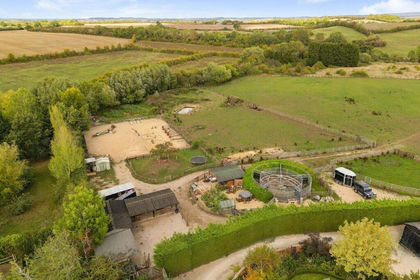
- Price
- Guide Price£450,000
- Size
- 8.76 acres
Added on 25/05/2026Equestrian property
- Price
- Guide Price£475,000
- Size
- 48.54 acres
Added on 29/01/2026Arable Land