
South Canterbury, Cornhill, Banff, AB45
- Land size
- 96.5 acres
- Bedrooms
- 3
- Bathrooms
- 2
Key Features
- Closing Date Wednesday 26th August at 12 noon
- Lot 1 - Spacious 3 bedroom dwellinghouse with great potential
- Lot 1 - Useful and versatile range of buildings
- Lot 1 - Set in approximately 17 acres (7 hectares) in total
- Lot 2 - IACS registered land extending to 82 acres (33 hectares)
- Lot 2 - Grade 3.2 productive land, suitable for grazing, grassland and arable production
- Good access to the B9022
Description
Local Information
South Canterbury lies in a picturesque rural yet accessible location near the village of Cornhill, around 5 miles south of the renowned Moray Firth coast in Aberdeenshire. Cornhill is a peaceful rural community and has a garage, church and village hall with local shops and services available in Portsoy around 4.5 miles to the north. Primary schooling is provided at Ordiquhill Primary School (2 miles).
South Canterbury enjoys good access links to the nearest towns of Banff and Keith, which are located to the northeast and southwest respectively. Both towns provide a wide range of services and amenities including secondary education, retailers, supermarkets, fuel stations, accommodation, eateries, healthcare, swimming pools, sports and community centres.
The nearby Moray Firth coast is famed for its temperate climate, beautiful beaches and traditional fishing villages and towns, such as Cullen and Portsoy. Aberdeenshire and Moray are highly regarded for recreational activities such as golf, mountain biking, hill walking, winter sports and fishing as well as its famous castle and whisky trails.
Agriculture plays a key role in the local Aberdeenshire economy. There is a plethora of dealerships, services and suppliers locally as well as veterinary practices in Banff and Keith. There are local livestock marts at Huntly and Thainstone near Inverurie which both hold regular weekly sheep and cattle sales throughout the year, as well as special sales, attracting buyers from across the country.
South Canterbury - Lot 1 OFFERS OVER £260,000
South Canterbury Farmhouse - Gross Internal Floor Area: approx. 122m2
A traditional detached dwellinghouse providing spacious three-bedroom accommodation and enjoying lovely south facing views over surrounding farmland. The property would benefit from upgrading and modernisation throughout, offering great potential and allowing a purchaser to personalise to their own taste.
Accommodation on the ground floor comprises dining kitchen, two reception rooms, shower room, bedroom and front porch. On the first floor are two bedrooms and a bathroom. The property has a mix of uPVC and timber framed predominantly double glazed windows and oil central heating.
To the front (south) is a good sized garden with area of lawn and vegetable patch with polytunnel. Adjoining to the west is a small grass paddock. There is a timber single garage and a timber/metal sheet clad store to the rear.
Property Details
Home Report:
Home Report is available on our website.
EPC:
Band F
Council Tax:
Band C
Windows & Doors:
uPVC / timber framed, mainly double glazed
Services:
Private water and private drainage to septic tank. Mains electricity. Oil central heating
Included in Sale:
Floor coverings, curtains and white goods
Buildings
South Canterbury is served by a range of useful buildings providing ample livestock housing and storage, with potential for alternative uses and development (subject to obtaining necessary planning permission).
The buildings extend to 900m2 or thereby in total, and comprise a large traditional U-shaped steading with steel portal frame in-fill court, adjoining timber frame building and a separate timber frame cart shed.
The traditional steading and in-fill court are supplied by electricity and water.
There are redundant traditional buildings situated within Fields 3 and 12.
Land
The land included in Lot 1 comprises Fields 6 and 13 extending to 14 acres or thereby. Including the buildings, yard and grounds surrounding the farmhouse, the total area of Lot 1 extends to approximately 17 acres (7 hectares) as identified shaded orange on the attached plan.
South Canterbury - Lot 2 OFFERS OVER £425,000
Lot 2 comprises a productive block of Grade 3(2) agricultural land extending to 82.5 acres (33.4 hectares) or thereby in total, identified shaded blue on the plan attached.
Basic Payment Scheme (BPS)
All the land is BPS Region 1 except Field 5 which is Region 2. Entitlements are not included in the asking price but are available by separate negotiation.
Land as a Whole
The IACS registered land at South Canterbury extends to 96.5 acres (39 hectares) or thereby in total, consisting of 13 field parcels as per the plan attached. Classified by the James Hutton Institute as Grade 3(2), the land is presently all in grass and utilised for livestock grazing however has had recent arable cropping. The field parcels are of practical size and benefit from good accessibility, stockproof fencing and are supplied by water troughs. South Canterbury sits at an altitude of 90m to 115m above sea level with the land generally flat lying.
Viewings
To arrange a viewing, contact Aberdeen & Northern Estates
Access
South Canterbury is accessed via a short private track off the adjacent B9022 road. If sold in lots, Lots 1 and 2 will have a shared access from point A to B and Lot 2 will be accessed from point B as indicated on the attached plan.
Local Authority:
Aberdeenshire Council, Woodhill House, Westburn Road, Aberdeen, AB16 5GB
Entry:
By arrangement
Sporting Rights:
Included in the sale, insofar as they are owned
Mineral Rights:
Reserved by the seller
VAT:
The subjects are opted to tax therefore VAT will be payable on the purchase price (excepting the farmhouse)
Note:
Prospective purchasers should note that unless their interest in the property is formally intimated to the selling agents following inspection, the agents cannot guarantee that notice of a closing date for offers will be advised and consequently the property may be sold without notice.
Anti Money Laundering Compliance:
In accordance with The Money Laundering, Terrorist Financing and Transfer of Funds (Information on the Payer) Regulations 2017, we are required to carry out checks and due diligence on property purchasers. If an offer has been accepted, the purchaser(s) will need to provide proof of identity, residence and proof of funds, as a minimum, prior to any transaction proceeding.
Offers:
Formal offers, in the acceptable Scottish form should be submitted, along with the relevant anti-money laundering paperwork in accordance with The Money Laundering, Terrorist Financing and Transfer of Funds (Information on the Payer) Regulations 2017, through a Scottish Solicitor, to the Selling Agent.
Servitude Rights, Burdens and Wayleaves:
The property is sold subject to and with the benefit of all servitude rights, including rights of access and rights of way, whether public or private. The buyer(s) will be held to have satisfied himself/themselves as to the nature of all such servitude rights and others.
Title:
The buyer(s) shall be bound to accept the title as it presently stands in the name of the seller(s) and the conveyance in favour of the buyer(s) shall be subject to all the exceptions, reservations, burdens and conditions presently contained in the title deeds. There shall be excepted from warrandice in the conveyance in favour of the buyer(s) any leases, tenancies, tenants' rights, missives, agreements, rights of possession, rights of way, access rights, and sewerage and drainage facilities, and all other servitudes and other rights without prejudice to the right of the buyer(s) to quarrel or impugn the same on any ground not inferring warrandice against the seller(s).
Map Location
Property details
- Tenure
- Freehold
- Council Tax Band
- Ask Agent
- Date Posted
- 2026-07-02
Market Value Analysis
Compared with 20 Farmland & Pasture listings in Scotland (75+ acres).
Utilities & Restrictions
Utilities
- Electricity
- Ask Agent
- Water
- Ask Agent
- Heating
- Ask Agent
- Broadband
- Ask Agent
- Sewerage
- Ask Agent
Rights & Restrictions
- Public Rights of Way
- Ask Agent
- Private Rights of Way
- Ask Agent
- Listed Property
- Ask Agent
- Restrictions
- Ask Agent
Listed status, conservation areas and planning constraints for this location are in the full report.
Property Features
- Accessibility
- Ask Agent
- Parking
- Parking Available
- Garden
- Garden
Beyond the particulars: planning activity, flood history, heritage and ground risks, checked for this exact spot.
Connectivity
Broadband
Fastest speed available at this postcode
1.8 Gbps
Gigabit full fibre
Suitable for
- 4K streaming on every screen
- Full-time home working
- Online gaming & big downloads
Mobile signal
Predicted 4G and 5G signal; indoor signal depends on building materials.
Ofcom Connected Nations postcode-level predictions. Speeds and signal are modelled, not measured, and vary between addresses and providers.
Signal is the easy part. Planning activity, flood history and protected designations here are in the full report.
Nearest Schools
Primary
- Ordiquhill School1.7 miles
- Pupils
- 58
- Type
- Non-denominational
- Fordyce School2.7 miles
- Pupils
- 39
- Type
- Non-denominational
- Portsoy School4.1 miles
- Pupils
- 112
- Type
- Non-denominational
- Aberchirder School5.5 miles
- Pupils
- 110
- Type
- Non-denominational
- Cullen Primary School5.7 miles
- Pupils
- 102
- Type
- Non-denominational
Secondary
- Banff Academy7.6 miles
- Pupils
- 970
- Type
- Non-denominational
- Buckie High School9.8 miles
- Pupils
- 826
- Type
- Non-denominational
- Keith Grammar School9.8 miles
- Pupils
- 370
- Type
- Non-denominational
- Turriff Academy11 miles
- Pupils
- 623
- Type
- Non-denominational
- The Gordon Schools12 miles
- Pupils
- 665
- Type
- Non-denominational
Distances are straight-line from the advertised location. Source: the national school registers (DfE, Welsh Government, Scottish Government) and Ofsted.
Schools are just the start: planning activity, heritage and any flood history here are in the full report.
Amenities
Supermarket
GP surgery
Pharmacy
Walking trail
Straight-line distances from the advertised location. Sources: NHS records, Geolytix supermarket locations, OS Open Greenspace and the national trails registers.
The area stacks up? Now check the location itself: planning nearby, protected designations and past flooding.
Getting Around
Nearest station
Nearest bus stop
Typical drive times
Straight-line distances from the advertised location; drive times are typical free-flow times over OpenStreetMap road data, so allow more at peak. Public transport locations from DfT NaPTAN.
Easy to reach matters. So do planning activity, flood history and ground risks: all in the full report.
Flood Risk
SEPA open data, checked around the advertised map pin for the listed acreage. Provided by LandSale, not the listing agent, and not part of the agent's particulars. Risk varies across a holding, so verify before committing.
Rivers and the sea
Not at the pin: mapped about 90 metres away.
Surface water
Not at the pin: mapped about 10 metres away.
These bandings are the summary. Where this location sits on the flood maps, plus planning activity, heritage and ground risks, is in the full report.
Important notice: Information, maps and tags on this page are drawn from the advertising agent's marketing materials or generated automatically. LandSale has not verified them. Relying on these details is at your own risk, always carry out independent checks before committing to a purchase.
LandSale full disclaimer
Marketing information only - not formal particulars. The details on this website are provided for general guidance and do not constitute an offer or contract. Neither LandSale nor the advertising estate/land agent accepts responsibility for any inaccuracy.
1. Source of information
- Listing content: Core description, asking price, tenure, measurements, photographs and planning history originate from the marketing materials of the advertising estate or land agent. LandSale does not author this content and cannot guarantee its accuracy.
- Automated tags & categorisation: Property type, land-use class, acreage bands and similar labels may be applied by machine-learning models. They are intended as a helpful guide only and may not reflect the property's legal status or permitted use.
- Third-party & enriched data layers: Maps, boundary outlines, planning designations, soil reports, broadband coverage and other environmental or location-based insights are licensed from external suppliers. Such data are supplied “as is", may be incomplete or out of date and are subject to change without notice.
2. Verification required
Prospective purchasers must verify critical matters, including but not limited to planning permission, title boundaries, public rights of way, environmental constraints, acreage, services, access and VAT status, through their own inspections, specialist surveys, legal advisers and the selling agent before relying on the information or entering into any contract.
3. No warranty or liability
LandSale gives no warranty, express or implied, as to the accuracy, completeness or fitness for any particular purpose of the information displayed. LandSale shall not be liable for any loss, damage, cost or expense arising directly or indirectly from any use of or reliance on such information, save where liability may not be excluded by law.
4. Updates & feedback
If you believe any detail on this listing is inaccurate, please let us know. We will investigate and, where appropriate, update the listing or notify the agent.
© LandSale | Version 1.3 - August 2026
Listing agent
Aberdeen & Northern (Estates) Ltd, Inverurie
Thainstone Agricultural Centre, Inverurie, AB51 5XZ
View agent profileSimilar properties for sale
- Price
- Offers Over£450,000
- Size
- 19 acres
Knock, Huntly, AB54, Aberdeenshire North and Moray East, Moray AB54 Scotland
Added on 22/05/2026House with Land
- Price
- Offers Over£449,000
- Size
- 7 acres
Of Rosieburn, Banff, AB45, Aberdeenshire North and Moray East, Aberdeenshire AB45 Scotland
Added on 12/10/2026House with Land
- Price
- Offers in Excess of£665,000
- Size
- 28 acres
Drybridge MORAY COAST, Aberdeenshire North and Moray East, Moray AB56 Scotland
Added on 08/10/2026Equestrian property
- Price
- Offers Over£525,000
- Size
- 2.5 acres
Added on 29/01/2026Kennels Property
- Price
- Offers Over£520,000
- Size
- 2 acres
Rathburn House, March Road, Buckie, Moray, Aberdeenshire North and Moray East, Moray AB56 Scotland
Added on 09/10/2026House with Land
- Price
- Offers Over£595,000
- Size
- 7 acres
Added on 09/10/2026Kennels Property
- Price
- Offers Over£585,000
- Size
- 12 acres
Added on 29/01/2026Equestrian property
- Price
- Offers Over£440,000
- Size
- 9 acres
Ythanwells, Huntly, AB54, Gordon and Buchan, Aberdeenshire AB54 Scotland
Added on 08/08/2026Equestrian property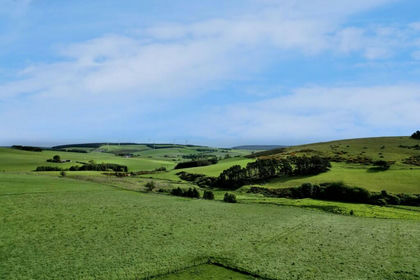
- Price
- Offers Over£445,000
- Size
- 25.75 acres
Added on 19/02/2026Farmland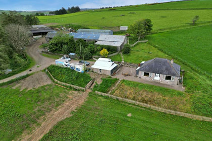
- Price
- Offers in Excess of£445,000
- Size
- 25.75 acres
Upper Lynemore, Keith, AB55, Moray West, Nairn and Strathspey, Moray AB55 Scotland
Added on 19/02/2026Smallholding