High Easter Road, Barnston, Great Dunmow, CM6
- Land size
- 4 acres
- Bedrooms
- 7
- Bathrooms
- 4
Key Features
- Secluded peaceful rural location but close to amenities and London links (M11 & rail)
- Fronting a stream and large pond
- Lawns, woodland, outbuildings, garage and open bay cart store
- Hard tennis court
- Delightful terrace overlooking the water
- Circular vegetable garden
- Entrance hall and inner hall
- 5 reception rooms
- Kitchen/breakfast room
- Utility & boiler room
Description
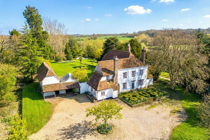
Martels Manor is an exceptional Medieval house, a Grade II Listed building with later additions and conventionally constructed with a heavy timber frame with plastered and pargetted elevations under a neat tiled roof. The current owners have undertaken significant works to the house over a number of years and have updated the property with great sympathy. This impressive country house has an attractive approach past farmland to a pair of automatic wrought iron gates leading to the private driveway. A secondary driveway leads beside and behind the house to the garaging and outbuildings. There is an extensive area of parking in front of the garage and around the house.
The accommodation is arranged over two floors and is surprisingly bright for a house of this age. It would appear that many of the windows to the front were replaced in the 18th or early 19th century and afford delightful views over the drive and grounds. On the ground floor there is a generously proportioned hall with oak panelling, an inner hall with staircase to the first floor, glazed summer room with double glazed windows with views over the garden. There are four further reception rooms, two with fireplaces and wood burning stoves, kitchen/breakfast room with Aga, stone sink, granite work surfaces and three sets of doors to the garden. There is also a utility room and a ground floor cloakroom. On the first floor the landing leads to the impressive master bedroom which has a vaulted roof, fitted wardrobes and an en suite shower room, a guest suite with its own en suite and storage and five further double bedrooms.
The grounds are very much a feature and extend to about four acres including lawns, an extensive terrace running around the property, an orchard of damson, plum and pear and an extensive area of deciduous woodland. A stream (a tributary of the River Chelmer) runs between the bottom of the garden and the woodland. A pond and rill have been created and beside the rill there is a large terrace which is a perfect entertaining area. The triple garage block is well equipped with three rollermatic doors, light and power and a cloakroom. There are also two bunded oil tanks. The sizeable open bay cart lodge provides dry storage and there is also an excellent garden store and workshop, a hard tennis court and circular vegetable garden with brick
The current owners will be very sad to leave, as they have enjoyed living in the house and have enjoyed the delightful location. These are some of the features which attracted them to the property and make living there special. “It is in a very convenient location, about 7 miles from the M11 on a good run 10 to 12 minutes and there are railway stations at Stansted Airport and Bishops Stortford. Excellent access to London City (less than an hour) and about one hour twenty minutes to Mayfair and the West End. There are good pubs a
short walk away. The historical Flitch town of Great Dunmow has interesting shops. The initial driveway is about a third of a mile long (the initial section is shared). The house is centrally located in its grounds and has a partial moat, there is private woodland and total seclusion with an abundance of wildlife including kingfishers, owls, buzzard, kites and deer. There is underfloor heating throughout the ground floor and modern insulation to the floors and loft, a modern chef ’s kitchen with Miele and Gaggenau fittings”.
Historical note: Martels Manor has significant history; in more recent times it was the home of Lord and Lady Plowden who resided there for many years either side of WW2. Lord Plowden was a British industrialist and public servant in the Treasury, during the war he served in the Ministry of Economic Warfare, and later joined the Ministry of Aircraft Production, in which he remained until 1946. During 1945–46 he was chief executive in succession to Air Chief Marshal Sir Wilfrid Freeman. Lady Plowden was a British educational reformer and influential figure in primary education, broadcasting and the rights of Romani people. She chaired the group which authored and published the 1967 Plowden Report on primary education in Britain, and was chair of the Independent Broadcasting Authority from 1975–80.
Barnston is a small village only 1½ miles from the market town of Great Dunmow. There are good facilities in Great Dunmow, including Michelin star restaurant, shops, primary and secondary schooling and various recreational amenities. A further range of facilities is provided in the market towns of Bishop’s Stortford and Chelmsford, both within 15 miles distance. Felsted Public School is some 5 miles from the property. There are mainline railway stations providing services top London’s Liverpool Street at both Bishop’s Stortford (approximately 35 minutes and Chelmsford. The A120 by-pass is about a mile from the property and has greatly improved travelling time to Bishops Stortford, Stansted Airport and the M11 (J8) which is about ten miles away and links to London, the M25, Cambridge and the Midlands.
Map Location
Property details
- Tenure
- Freehold
- Council Tax Band
- H
- Date Posted
- 2026-06-22
Market Value Analysis
Compared with 1,131 Homes with Land listings in East Anglia (1+ acres).
Utilities & Restrictions
Utilities
- Electricity
- Ask Agent
- Water
- Ask Agent
- Heating
- Ask Agent
- Broadband
- Ask Agent
- Sewerage
- Ask Agent
Rights & Restrictions
- Public Rights of Way
- Ask Agent
- Private Rights of Way
- Ask Agent
- Listed Property
- Ask Agent
- Restrictions
- Ask Agent
Property Features
- Accessibility
- Ask Agent
- Parking
- Parking Available
- Garden
- Garden
Connectivity
Broadband
Fastest speed available at this postcode
1.8 Gbps
Gigabit full fibre
Suitable for
- 4K streaming on every screen
- Full-time home working
- Online gaming & big downloads
Fixed wireless access may also be an option here.
Mobile signal
Outdoor predictions; indoor signal depends on building materials.
Ofcom Connected Nations postcode-level predictions. Speeds and signal are modelled, not measured, and vary between addresses and providers.
Nearest Schools
Primary
- Dunmow St Mary's Primary School1.6 milesOfsted: Good
- Ages
- 4 to 11
- Pupils
- 459
- Type
- Foundation school
- Faith
- Church of England
- Great Dunmow Primary School1.9 milesOfsted: Good *
- Ages
- 4 to 11
- Pupils
- 421
- Type
- Foundation school
- The Flitch Green Academy1.9 milesOfsted: Good *
- Ages
- 4 to 11
- Pupils
- 272
- Type
- Academy converter
- Helena Romanes School2.3 milesOfsted: Good
- Ages
- 4 to 18
- Pupils
- 1,265
- Type
- Academy converter
- Ford End Church of England Primary School3.2 milesOfsted: Good
- Ages
- 4 to 11
- Pupils
- 47
- Type
- Academy converter
- Faith
- Church of England
Secondary
- Helena Romanes School2.3 milesOfsted: Good
- Ages
- 4 to 18
- Pupils
- 1,265
- Type
- Academy converter
- Chelmer Valley High School6.8 milesOfsted: Good
- Ages
- 11 to 18
- Pupils
- 1,200
- Type
- Academy converter
- Tabor Academy7.5 milesOfsted: Requires improvement
- Ages
- 11 to 18
- Pupils
- 989
- Type
- Academy converter
- Notley High School and Braintree Sixth Form7.6 milesOfsted report card · May 2026
- Ages
- 11 to 19
- Pupils
- 1,210
- Type
- Academy converter
- Forest Hall School7.7 milesOfsted report card · Feb 2026
- Ages
- 11 to 16
- Pupils
- 506
- Type
- Academy sponsor led
* Latest graded judgement covers quality of education only; no overall grade was issued under the 2024-25 inspection framework.
Distances are straight-line from the advertised location. Source: the national school registers (DfE, Welsh Government, Scottish Government) and Ofsted.
Amenities
Supermarket
GP surgery
Pharmacy
Hospital
Green space
Straight-line distances from the advertised location. Sources: NHS records, Geolytix supermarket locations, OS Open Greenspace and the national trails registers.
Getting Around
Nearest station
Nearest bus stop
Typical drive times
Straight-line distances from the advertised location; drive times are typical free-flow times over OpenStreetMap road data, so allow more at peak. Public transport locations from DfT NaPTAN.
Flood Risk
From Environment Agency flood map open data, checked around the advertised map pin and allowing for the listed acreage where known. This summary comes from LandSale, the advertising platform, not from the listing agent, and is not part of the agent's particulars. Risk can vary across a single holding, so verify anything critical through your own searches before committing.
Rivers and the sea
Surface water
The detail behind these bandings, including exact zones and annual chances, any recorded past flooding, plus planning, heritage, nature and ground checks, is in the .
Important notice: Information, maps and tags on this page are supplied by the advertising agent or generated automatically. LandSale has not verified them. Relying on these details is at your own risk, always carry out independent checks before committing to a purchase.
LandSale full disclaimer
Marketing information only - not formal particulars. The details on this website are provided for general guidance and do not constitute an offer or contract. Neither LandSale nor the advertising estate/land agent accepts responsibility for any inaccuracy.
1. Source of information
- Agent-supplied content: Core description, asking price, tenure, measurements, photographs and planning history are uploaded by the appointed agent, who remains solely responsible for their accuracy.
- Automated tags & categorisation: Property type, land-use class, acreage bands and similar labels may be applied by machine-learning models. They are intended as a helpful guide only and may not reflect the property's legal status or permitted use.
- Third-party & enriched data layers: Maps, boundary outlines, planning designations, soil reports, broadband coverage and other environmental or location-based insights are licensed from external suppliers. Such data are supplied “as is", may be incomplete or out of date and are subject to change without notice.
2. Verification required
Prospective purchasers must verify critical matters, including but not limited to planning permission, title boundaries, public rights of way, environmental constraints, acreage, services, access and VAT status, through their own inspections, specialist surveys, legal advisers and the selling agent before relying on the information or entering into any contract.
3. No warranty or liability
LandSale gives no warranty, express or implied, as to the accuracy, completeness or fitness for any particular purpose of the information displayed. LandSale shall not be liable for any loss, damage, cost or expense arising directly or indirectly from any use of or reliance on such information, save where liability may not be excluded by law.
4. Updates & feedback
If you believe any detail on this listing is inaccurate, please let us know. We will investigate and, where appropriate, update the listing or notify the agent.
© LandSale | Version 1.2 - January 2026
Listing agent
Mullucks, Bishop's Stortford
The Guild House Water Lane Bishop's Stortford CM23 2JZ
Contact Mullucks, Bishop's Stortford
The Guild House Water Lane Bishop's Stortford CM23 2JZ
View agent profileSimilar properties for sale
- Price
- Guide Price£1,850,000
- Size
- 10 acres
Added on 09/07/2026Country Estate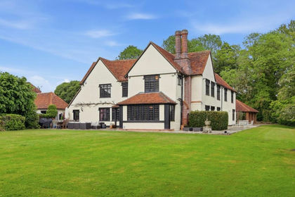
- Price
- £1,950,000
- Size
- 3 acres
Added on 24/06/2026Country Home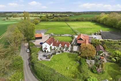
- Price
- Offers in Excess of£1,350,000
- Size
- 5.1 acres
Added on 02/05/2026Equestrian property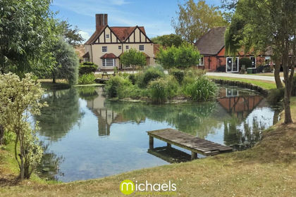
- Price
- £1,500,000
- Size
- 2.05 acres
Whites Hill, Coggeshall, Colchester, CO6, Bradwell, Essex CO6 England
Added on 08/08/2026Country Home
- Price
- Offers in Excess of£2,000,000
- Size
- 12 acres
Coggeshall Road, Kelevdon, Essex, CO5, Kelvedon, Essex CO5 England
Added on 29/01/2026Country Estate
- Price
- Guide Price£1,925,000
- Size
- 2.1 acres
Goat Lodge Road, Great Totham, CM9, Great Totham, Essex CM9 England
Added on 13/05/2026Country Home
- Price
- Offers in Excess of£1,695,000
- Size
- 3.8 acres
Added on 22/07/2026Country Home
- Price
- £2,000,000
- Size
- 2.37 acres
Added on 10/05/2026Country Home
- Price
- £2,000,000
- Size
- 2.37 acres
Added on 11/08/2026Country Home
- Price
- Guide Price£1,600,000
- Size
- 8.5 acres
Cricketers Lane, Herongate, CM13, Herongate and Ingrave, Essex CM13 England
Added on 30/07/2026Country Home