Bainleyside Farm, Great Fryupdale, Lealholm
- Land size
- 37.61 acres
- Bedrooms
- 4
- Bathrooms
- 1
Key Features
- Small Residential Stock Farm
- Set In The Heart Of The North York Moors National Park
- Modern & Traditional Buildings
- Set In Approximately 37.61 Acres
Description
PARTICULARS OF SALE
Bainleyside Farm is an attractive traditional farm holding, which would now be considered small in commercial terms, located on the east side of Fryupdale. The property lies approximately 200 yards downhill from the former Methodist Chapel which has now been converted to a house.
The nearest amenities lie in the village of Lealholm, which is around 2½ miles away to the north. The property has good access via a tarmac driveway leading from the dale road.
Bainleyside Farm is a small stock farm including a traditional stone built house and range of outbuildings, plus a slightly more modern Dutch barn and lean-to.
The Farmhouse
The house has a total of 4 bedrooms on the first floor, plus 2 spacious attic rooms which could be converted to provide additional accommodation.
To the ground floor there is a large reception room, dining room, fitted kitchen, bathroom and a pantry plus an entrance vestibule. The house has had some limited modernisation, but would require substantial renovation for most modern residential tastes. The farmhouse is built of local stone under a tiled roof which has 2 differing coloured tiles.
The Land
The land at Bainleyside Farm extends to approximately 36.94 acres (14.95 hectares) plus the farmstead. All of the land is down to permanent pasture and lies mainly to the north of a block which surrounds the farm yard, within a ring fence.
The fields stretch from the dalesides road to the stream in the bottom and are all bounded by either post and wire fences or dry-stone walls which need attention in places. The land is typical dalesides land of the area with some fields being capable of being mown however many fields are ripe for re-seeding.
Farm Buildings
The farm buildings lie to the north werst of the farm house and mainly comprise traditional ranges which have not been utilised for some years. The numbering below refers to the buildings as marked on the farmyard plan.
Buildings
1 Farmhouse and adjoining barn.
See Floor plans attached
2 40ft x 18ft A traditional range constructed of stone with pantile roof with double doored cart shed adjoining stable with external steps to a hen house over. To the south of this range and adjoining appears to be a former ice house built into the hillside.
3 56ft x 21ft Traditional range constructed of stone under a pantile roof. Comprising cow byre with granary over and barn on 1 ½ heights.
3a 25ft x 15ft Adjoining traditional range of the same construction. Comprising pig stye with stable box and meal house.
4 40ft x 18ft Adjoining more modern cow byre constructed of concrete blocks (no roof) with standings for 8 cows together with tank and parlour room, concrete floor.
5 20ft x 18ft A nissen hut garage / workshop constructed of brick gable ends with RFC arched walls / roof with earthen floor.
6 45ft x 30ft Three bay Dutch barn. Constructed of pole supports under an RFC sheeted roof. One end is CI sheets with the other two sides being open. Eathen floor with partially derelict two bay lean-to.
7 45ft x 30ft Three bay lean-to to the above. Constructed of pole supports with concrete block lower walls, RFC upper walls and roof with concrete floor and CI sheeted gable ends.
GENERAL REMARKS & STIPULATIONS
Method of Sale: The property is offered for sale by private treaty negotiation as a single lot.
Viewing: Viewings are strictly by appointment with the sole selling agent. All interested parties should discuss any specific issues that might affect their interest, with the agent’s office prior to making an appointment to view this property.
Directions: See also location and boundary plans. Travelling on the A171 between Whitby and Guisborough, follow the signs to Lealholm in the mid Esk Valley. From Lealholm village cross the bridge with the pub on your right and drive south until you reach a cross roads on the edge of the moor. Go straight across and drive up onto the moor for around a mile until you reach a sign with a single track road to your right. Follow this road into Fryup Dale, crossing the cattle grid and then turn right onto the dale road. From this road take the second left by the former chapel and a road descends to Bainleyside Farm.
Tenure: The property is held freehold and will be available with vacant possession on completion. Sporting & mineral rights are in hand and will pass on completion.
Wayleaves Easements, etc: The property is offered for sale subject to and with the benefit of all wayleaves, easements, rights of way etc, whether mentioned in these particulars or not. The property is understood to have public footpaths crossing it.
Post Code: YO21 2AS
Subsidy Entitlements and Environmental Schemes: The land has all been delinked from the BPS subsidy scheme and therefor there are no entitlements to transfer. Similarly, none of the land is currently entered into any environmental stewardship scheme.
Planning: North York Moors National Park. Tel: . It should be noted that neither the house, nor the traditional farm buildings are listed.
Services: It is understood that the farmhouse is connected to a spring water supply which is also shared with the nearby former chapel. Foul drainage runs to a septic tank. The property has mains electricity. .
Council Tax / Business Rates: The farmhouse is assessed as band ‘D’ approx. £2,418 payable for 2026-27. North Yorkshire Council - Tel .
What3words: sage.testy.lobster
IMPORTANT NOTICE
Richardson and Smith have prepared these particulars in good faith to give a fair overall view of the property based on their inspection and information provided by the vendors. Nothing in these particulars should be deemed to be a statement that the property is in good structural condition or that any services or equipment are in good working order as these have not been tested. Purchasers are advised to seek their own survey and legal advice.
Map Location
Property details
- Tenure
- Freehold
- Council Tax Band
- D
- Date Posted
- 2026-06-04
Market Value Analysis
Compared with 22 Farms & Smallholdings listings in Yorkshire and The Humber (25+ acres).
Utilities & Restrictions
Utilities
- Electricity
- Mains
- Water
- Private Supply
- Heating
- Ask Agent
- Broadband
- Ask Agent
- Sewerage
- Septic Tank / Private
Rights & Restrictions
- Public Rights of Way
- Ask Agent
- Private Rights of Way
- Yes
- Listed Property
- Ask Agent
- Restrictions
- Ask Agent
Property Features
- Accessibility
- Ask Agent
- Parking
- Driveway
- Garden
- Garden
Important notice: Information, maps and tags on this page are supplied by the advertising agent or generated automatically. LandSale has not verified them. Relying on these details is at your own risk, always carry out independent checks before committing to a purchase.
LandSale full disclaimer
Marketing information only - not formal particulars. The details on this website are provided for general guidance and do not constitute an offer or contract. Neither LandSale nor the advertising estate/land agent accepts responsibility for any inaccuracy.
1. Source of information
- Agent-supplied content: Core description, asking price, tenure, measurements, photographs and planning history are uploaded by the appointed agent, who remains solely responsible for their accuracy.
- Automated tags & categorisation: Property type, land-use class, acreage bands and similar labels may be applied by machine-learning models. They are intended as a helpful guide only and may not reflect the property's legal status or permitted use.
- Third-party & enriched data layers: Maps, boundary outlines, planning designations, soil reports, broadband coverage and other environmental or location-based insights are licensed from external suppliers. Such data are supplied “as is", may be incomplete or out of date and are subject to change without notice.
2. Verification required
Prospective purchasers must verify critical matters, including but not limited to planning permission, title boundaries, public rights of way, environmental constraints, acreage, services, access and VAT status, through their own inspections, specialist surveys, legal advisers and the selling agent before relying on the information or entering into any contract.
3. No warranty or liability
LandSale gives no warranty, express or implied, as to the accuracy, completeness or fitness for any particular purpose of the information displayed. LandSale shall not be liable for any loss, damage, cost or expense arising directly or indirectly from any use of or reliance on such information, save where liability may not be excluded by law.
4. Updates & feedback
If you believe any detail on this listing is inaccurate, please let us know. We will investigate and, where appropriate, update the listing or notify the agent.
© LandSale | Version 1.2 - January 2026
Similar properties for sale

- Price
- Offers in Excess of£695,000
- Size
- 16.29 acres
High Butterwitts Farm, Danby, YO21 2LL, Danby, North Yorkshire YO21 2LN England
Added on 29/01/2026Smallholding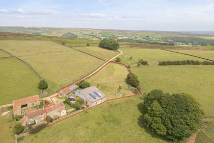
- Price
- Offers in Excess of£465,000
- Size
- 1 acres
Farndale, York, Farndale West, North Yorkshire YO62 7JX England
Added on 03/07/2026Smallholding
- Price
- Guide Price£650,000
- Size
- 23.4 acres
Ganthorpe, York, Terrington, North Yorkshire YO60 6QD England
Added on 29/01/2026Barn Conversion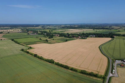
- Price
- Guide Price£550,000
- Size
- 57.2 acres
Skirpenbeck, York, Skirpenbeck, East Riding of Yorkshire YO41 1HG England
Added on 11/07/2026Farm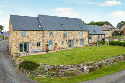
- Price
- Offers Over£795,000
- Size
- 1.58 acres
Old Wingate Farm, Trimdon Station, TS29, Wheatley Hill, County Durham TS29 6NU England
Added on 02/07/2026Barn Conversion
- Price
- £400,000
- Size
- 48.82 acres
Added on 14/04/2026Arable Land- Price
- £400,000
- Size
- 48.82 acres
Added on 14/04/2026Arable Land
- Price
- Guide Price£850,000
- Size
- 16 acres
High Farm, West Lane, Whixley, York, Whixley, North Yorkshire YO26 8AX England
Added on 27/06/2026Smallholding
- Price
- Guide Price£530,000
- Size
- 30 acres
Added on 04/02/2026Equestrian property
- Price
- £820,000
- Size
- 19.74 acres
Etherley, Bishop Auckland, County Durham, DL14, Evenwood and Barony, County Durham DL14 0LT England
Added on 28/01/2026Smallholding