Etherley, Bishop Auckland, County Durham, DL14
- Land size
- 19.74 acres
- Bedrooms
- 4
- Bathrooms
- 2
Key Features
- Detached Bungalow
- Four Bedrooms
- 19.74 Acres
- Farm Buildings
- Workshop Buildings
- Countryside Views
Description
An exciting opportunity to purchase a small holding/equestrian/small business premises which extends to approximately 7.99 Hectares (19.74 acres) in total. The bungalow benefits from full length windows to the lounge with views over the garden to the open countryside beyond.
The land is predominately grass pasture/meadow and is ring fenced. The farm buildings include a livestock building, small cattle yard machinery store, and hay/straw shed. In addition, there is range of workshop buildings associated with the vendor's joinery business. Please note the wood working equipment is available to purchase by separate negotiation if desired.
LOCATION
The property is conveniently located on the outskirts of
Etherley benefiting from a pleasant rural setting whilst being only a short
drive from the shops and services available
in Bishop Auckland.
WHAT3WORDS
What3words: ///landlady.unto.fakes
ACCOMMODATION
Entrance Hall
Solid timber door, radiator and stained glass panels.
Shower Room
Fully tiled with shower cubicle, heated towel rail, wash hand basin and low level wc.
Kitchen
Fitted wall and floor cupboards, electric cooker point with extractor hood over, sink unit with double drainer, integrated fridge, freezer and dishwasher. Within the kitchen there is a breakfast bar ideal for informal dining with the benefit of added storage.
Dining Room
Radiator and two windows enjoying views over the garden.
Living Room
Large picture windows with views to the west over the lawn and Weardale beyond. Radiator, stone fireplace with open coal fire and double glazed doors to the garden.
Bedroom One
Window to the front elevation, built-in wardrobe and radiator.
Bedroom Two
Bedroom to the rear elevation, built-in wardrobe and radiator.
Bedroom Three
Bedroom to the rear elevation, built-in wardrobe and radiator.
Bedroom Four
Bedroom to the rear elevation, built-in wardrobe and radiator.
Bathroom
Cast iron roll top bath with shower attachment, radiator incorporating towel rail, low level wc, pedestal wash hand basin, built-in storage cupboard and part tiled walls.
Utility
Tiled floor, radiator, plumbing for washing machine and Belfast sink.
Cloakroom
Low level wc and radiator
Store Cupboard One
Store Cupboard Two
EXTERNALLY
Garage
Remote control up and over garage door, side access door, oil central heating boiler and main consumer unit.
Garage Two
T-fall room, brick and block walls with power and light instralled.
Kennel and Dog Run
Sales Office
Toilet
Coal House/Store
Joinery Building
Dust extractors. Note the wood working equipment can be included within the sale.
Tool Store
Store Yard Area
Timber framed building with concrete floor. Open concrete yard with feed passage.
Machinery Shed
Open fronted with gates, concrete floor with both mains water and lighting.
Hay Shed
Dual pitch sheet steel roof
TENURE
The land is freehold and is registered under title DU318560.
The land was formerly copyhold of the Manor of Evenwood.
Vacant possession is available after the expiry of the current
grazing agreement which terminates on 30 September 2025.
SALE PLAN
The property is shown edged red on the attached sale plan.
LAND
The grassland comprises three enclosures within a ring fence.
The field boundaries are a mix of wire fences and hedges.
Description
Area (Hectares)
Area (acres)
Grass/ Meadow
Pasture
6.84
16.90
Woodland(grazeable)
0.57
1.41
Steading/Buildings/Garden/Grounds
etc
0.58
1.43
Total
7.99
19.74
ACCESS
Access to the property is from the adopted highway over the access
road (shaded orange on the sale plan). The access road is not included in the
ownership.
SERVICES
Mains water and mains electricity are connected. Private drainage to a septic tank. An oil-fired boiler supplies hot water and central heating to the bungalow.
The land adjacent to the farm buildings has the benefit of a natural water supply. No warranty is given or implied regarding water quality or continuity of supply.
COUNCIL TAX
Green
Copse Farm Bungalow: Band E
BUSINESS RATES
The workshop buildings are assessed for Business Rates. An online search at shows the Rateable Value is £2,750. The property is described as Workshop and premises. The property does qualify for 0% Small Business Rates Relief.
EASEMENTS, WAYLEAVES & RIGHTS OF WAY
The land is sold subject to and with the benefit of all rights of way, drainage, water courses, light and other easements, quasi or reputed easements and rights of adjoining landowners (if any) affecting the same and all matters registerable by any competent authority pursuant subject to statute.
The land is crossed by a public bridleway and public footpaths. For further is available from the selling agent or at
OVERAGE
The land is sold subject to a development clawback provision (in favour of the vendors and their successors in title). The payment due being equivalent to 25% of the uplift in value arising on the grant of a planning permission for anything other than an agricultural or equestrian use for a term of 50 years.
METHOD OF SALE
The land is offered for sale by private treaty. All interested parties are advised to register their interest so they can be advised on how the sale will be concluded. We reserve the right to proceed to final offers.
COSTS
Each party is to bear their own costs.
LEGAL FORMALITIES
Exchange of contracts will take place as soon as possible, but in any event no later than the expiry of 8 weeks from instruction of solicitors, with completion 7 days thereafter.
LOCAL AUTHORITY
Durham County Council, County Hall, Aykley Heads, Durham DH1 5UL.
Telephone
PRICE
£820,000
VIEWING
Please contact the selling agent T: opt 1
BROCHURE
Photographs May 2025.
Brochure prepared June 2025.
Property Information
Land Registry Title Number:DU318560Council Tax Band: EAnnual Cost:£3,118Tenure: FreeholdLocal Authority: DurhamFlood Risk: Very lowConservation Area: NoPredicted Broadband Speeds Basic:5 Mbps Superfast:31 MbpsSatellite / Fibre TV Availability: BT & SkySURVEYWe have not undertaken a survey of the property and therefore are unable to comment on its structural condition. This property has a restrictive covenants and easements that will be verified by the sellers solicitor.
Map Location
Property details
- Tenure
- Freehold
- Council Tax Band
- E
- Date Posted
- 2026-01-28
Price history
| Date | Change | Price |
|---|---|---|
| 17 Sep 2026 | Reduced 9.8% (−£80,000) | £740,000 |
| Until 17 Sep 2026 | Asking price | £820,000 |
Market Value Analysis
Compared with 23 Farms & Smallholdings listings in North East England (10+ acres).
Energy Performance Certificate
Energy Efficiency Rating
Based on UK Energy Performance Certificate standards (EU Directive 2002/91/EC)
Running costs are one side. Planning activity, flood history and ground risks for this location are in the full report.
Utilities & Restrictions
Utilities
- Electricity
- Ask Agent
- Water
- Ask Agent
- Heating
- Ask Agent
- Broadband
- Ask Agent
- Sewerage
- Ask Agent
Rights & Restrictions
- Public Rights of Way
- Ask Agent
- Private Rights of Way
- Ask Agent
- Listed Property
- Ask Agent
- Restrictions
- Ask Agent
Listed status, conservation areas and planning constraints for this location are in the full report.
Property Features
- Accessibility
- Ask Agent
- Parking
- Parking Available
- Garden
- Garden
Beyond the particulars: planning activity, flood history, heritage and ground risks, checked for this exact spot.
Connectivity
Broadband
Fastest speed available at this postcode
1.8 Gbps
Superfast
Suitable for
- 4K streaming on every screen
- Full-time home working
- Online gaming & big downloads
Mobile signal
Predicted 4G and 5G signal; indoor signal depends on building materials.
Ofcom Connected Nations postcode-level predictions. Speeds and signal are modelled, not measured, and vary between addresses and providers.
Signal is the easy part. Planning activity, flood history and protected designations here are in the full report.
Nearest Schools
Primary
- Toft Hill Primary School906 metresOfsted: Good *
- Ages
- 4 to 11
- Pupils
- 203
- Type
- Community school
- St Chad's Catholic Primary School, Witton Park0.7 milesOfsted: Good
- Ages
- 3 to 11
- Pupils
- 57
- Type
- Academy converter
- Faith
- Catholic
- Escomb Primary School1.5 milesOfsted report card · Mar 2026
- Ages
- 3 to 11
- Pupils
- 160
- Type
- Community school
- Witton-le-Wear Primary School1.8 milesOfsted: Outstanding *
- Ages
- 2 to 11
- Pupils
- 114
- Type
- Academy converter
- Ramshaw Primary School2.1 milesNo Ofsted rating
- Ages
- 4 to 11
- Pupils
- 54
- Type
- Community school
Secondary
- St John's Catholic School & Sixth Form College2.4 milesNo Ofsted rating
- Ages
- 11 to 18
- Pupils
- 1,229
- Type
- Academy converter
- Faith
- Roman Catholic
- Bishop Barrington Academy2.4 milesOfsted: Good
- Ages
- 11 to 16
- Pupils
- 599
- Type
- Academy converter
- King James I Academy Bishop Auckland3.2 milesOfsted report card · Mar 2026
- Ages
- 11 to 18
- Pupils
- 936
- Type
- Academy converter
- Parkside Academy4.3 milesOfsted: Good
- Ages
- 11 to 16
- Pupils
- 833
- Type
- Academy converter
- Staindrop Academy6 milesOfsted: Good
- Ages
- 11 to 16
- Pupils
- 504
- Type
- Academy sponsor led
* Latest graded judgement covers quality of education only; no overall grade was issued under the 2024-25 inspection framework.
Distances are straight-line from the advertised location. Source: the national school registers (DfE, Welsh Government, Scottish Government) and Ofsted.
Schools are just the start: sold prices nearby, planning activity and any flood history are in the full report.
Amenities
Supermarket
GP surgery
Pharmacy
Hospital
Green space
Straight-line distances from the advertised location. Sources: NHS records, Geolytix supermarket locations, OS Open Greenspace and the national trails registers.
The area stacks up? Now check the location itself: planning nearby, protected designations and past flooding.
Getting Around
Nearest station
Nearest bus stop
Typical drive times
Straight-line distances from the advertised location; drive times are typical free-flow times over OpenStreetMap road data, so allow more at peak. Public transport locations from DfT NaPTAN.
Easy to reach matters. So do planning activity, flood history and ground risks: all in the full report.
Flood Risk
Environment Agency open data, checked around the advertised map pin for the listed acreage. Long-term risk counts flood defences; the planning map's flood zones do not. Provided by LandSale, not the listing agent, and not part of the agent's particulars. Risk varies across a holding, so verify before committing.
Rivers and the sea
Planning map: Flood Zone 1.
Surface water
Not at the pin: mapped about 40 metres away.
These bandings are the summary. Where this location sits on the flood maps, plus planning activity, heritage and ground risks, is in the full report.
Important notice: Information, maps and tags on this page are drawn from the advertising agent's marketing materials or generated automatically. LandSale has not verified them. Relying on these details is at your own risk, always carry out independent checks before committing to a purchase.
LandSale full disclaimer
Marketing information only - not formal particulars. The details on this website are provided for general guidance and do not constitute an offer or contract. Neither LandSale nor the advertising estate/land agent accepts responsibility for any inaccuracy.
1. Source of information
- Listing content: Core description, asking price, tenure, measurements, photographs and planning history originate from the marketing materials of the advertising estate or land agent. LandSale does not author this content and cannot guarantee its accuracy.
- Automated tags & categorisation: Property type, land-use class, acreage bands and similar labels may be applied by machine-learning models. They are intended as a helpful guide only and may not reflect the property's legal status or permitted use.
- Third-party & enriched data layers: Maps, boundary outlines, planning designations, soil reports, broadband coverage and other environmental or location-based insights are licensed from external suppliers. Such data are supplied “as is", may be incomplete or out of date and are subject to change without notice.
2. Verification required
Prospective purchasers must verify critical matters, including but not limited to planning permission, title boundaries, public rights of way, environmental constraints, acreage, services, access and VAT status, through their own inspections, specialist surveys, legal advisers and the selling agent before relying on the information or entering into any contract.
3. No warranty or liability
LandSale gives no warranty, express or implied, as to the accuracy, completeness or fitness for any particular purpose of the information displayed. LandSale shall not be liable for any loss, damage, cost or expense arising directly or indirectly from any use of or reliance on such information, save where liability may not be excluded by law.
4. Updates & feedback
If you believe any detail on this listing is inaccurate, please let us know. We will investigate and, where appropriate, update the listing or notify the agent.
© LandSale | Version 1.3 - August 2026
Listing agent
Addisons Chartered Surveyors, Barnard Castle
13 Galgate, Barnard Castle, DL12 8EQ
View agent profileSimilar properties for sale
- Price
- £600,000
- Size
- 18.28 acres
Hurst, Richmond, North Yorkshire, DL11, Marrick, North Yorkshire DL11 England
Added on 01/05/2026Farmland
- Price
- Guide Price£725,000
- Size
- 10.5 acres
Sparty Lea, Hexham, NE47, Allendale, Northumberland NE47 England
Added on 01/10/2026Smallholding
- Price
- Guide Price£650,000
- Size
- 22.3 acres
Ingleby Arncliffe, Northallerton, Ingleby Arncliffe, North Yorkshire DL6 England
Added on 24/09/2026Development Land
- Price
- £695,000
- Size
- 70.47 acres
Syke Side Farm, Kirkby Stephen, Cumbria, CA17, Soulby, Westmorland and Furness CA17 England
Added on 10/08/2026Farmland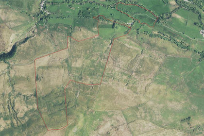
- Price
- Guide Price£645,000
- Size
- 150.29 acres
Apperset, Hawes, Leyburn, North Yorkshire, DL8, Hawes, North Yorkshire DL8 England
Added on 21/05/2026Grazing Land