Llanio Road, Tregaron
- Land size
- 30 acres
- Bedrooms
- 4
Key Features
- A lovely traditional livestock farm.
- Large 4 bed farmhouse.
- Ranges of traditional stone buildings and modern barns.
- Level lands with river frontage offered for sale in two lots.
- Lot 1 - The homestead and approx 30 acres of land - Guide Price £600,000.
- Lot 2 - Approx 77 acres of Teifi valley meadow land - Guide Price £350,000.
Description
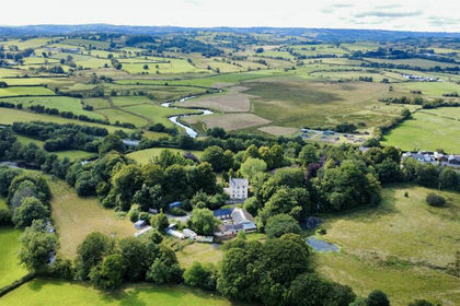
A lovely traditional livestock farm nestling on the banks of the River Teifi with a large 4 bed farmhouse, substantial well maintained ranges of traditional stone buildings, modern barns and level lands with river frontage offered for sale in two lots.
Lot 1 - The homestead and approx 30 acres of land - Guide Price £600,000
Lot 2 - Approx 77 acres of Teifi valley meadow land with approx 55 acres being part of the Bryn Maen SSSI - Guide Price £350,000
To be offered for sale by Private Treaty - Reply to the sole selling agents Evans Bros Lampeter
Location - Occupying a picturesque position on the banks of the River Teifi, the property is situated within the rural hamlet of Llanio, a peaceful and unspoilt setting in the heart of the Ceredigion countryside. Despite its tranquil location, the property is conveniently placed just a short drive from the market town of Tregaron, offering a useful range of everyday amenities. The university town of Lampeter lies within easy reach, providing a wider selection of shops, services and schooling, while the coastal town of Aberystwyth offers an extensive array of facilities, including retail, leisure and transport links. The area is renowned for its natural beauty, with the Teifi Valley and surrounding countryside providing excellent opportunities for walking, fishing and outdoor pursuits.
Of particular note, the land includes the remains of original Roman fort and baths, adding a unique element of historical interest, and forms part of a designated Site of Special Scientific Interest (SSSI), recognising the ecological and environmental significance of the surrounding landscape.
Description - An attractive property with a traditional farmhouse originally constructed in 1793 with the benefit of oil-fired central heating and offering characterful yet improvable accommodation including the following:
Feature Oak-Framed Entrance Porch - 3.45m x 1.30m (11'4 x 4'3) - A fantastic entrance to this property with slate tiled flooring and feature oak framing.
Breakfast / Dining Area - 4.19m x 4.06m (13'9 x 13'4) - An attractive room with oak panelled walls housing an integrated TV cupboard with feature fireplace and rear window.
Kitchen - 7.06m x 2.46m (23'2 x 8'1) - With an extensive range of kitchen units at base and wall level incorporating an electric oven and hob, double bowl sink unit with beamed ceilings and tiled flooring.
Rear Utility Room - 5.18m x 2.59m (17 x 8'6) - With Belfast sink unit, oil-fired boiler and rear entrance door.
Front Hallway - With main entrance door, access to understairs storage cupboard and radiator.
Living Room - 5.38m x 4.88m (17'8 x 16) - With a feature stone fireplace and chimney breast, tongue and groove ceilings and double aspect windows.
Dining Room - 4.67m x 3.61m (15'4 x 11'10) - With oak panelled walls, timber flooring and fireplace.
First Floor -
Landing - With access to loft.
Master Bedroom 1 - 5.36m x 4.70m (plus recess 2.77m x 1.35m) (17'7 x - With double aspect windows and radiator.
Rear Ensuite - 4.50m x 2.67m (14'9 x 8'9) - Having a cast iron roll-top bath, vanity unit with wash handbasin inset, toilet, separate shower cubicle and door to airing cupboard and access to under eaves storage.
Bedroom 2 - 4.67m x 3.66m (15'4 x 12) - With tiled fireplace, radiator and front window.
Bedroom 3 - 3.18m x 1.83m (10'5 x 6) - With window and radiator.
Rear Landing -
Bathroom - Having bath, toilet, wash handbasin, attractive half-tiled walls, Velux roof window and rear window.
Bedroom 4 - 3.71m x 2.44m (12'2 x 8) - With side window and radiator.
Externally - The property boasts extensive outbuildings being approached via a hard based driveway over an original railway bridge leading to an extensive yard area flanked by two traditional stone ranges. At the bottom of the yard, there are former pigsties and runs.
Range 1 - Comprises the barn and cowshed with an initial barn area, large cowshed, adjoining garage and former cooler-house / loose box. To the rear of this building is a large timber and portal frame barn
Barn Area - 7.16m x 5.33m (23'6 x 17'6) - With feed bin in loft area.
Large Cowshed - 5.23m x 4.95m (17'2 x 16'3) - With original cowshed divisions.
Timber And Portal Frame Barn - 45.72m x 13.72m overall (150 x 45 overall) - Incorporating 4 stable boxes with covered feeding veranda (8'5 x 150').
Range 2 - This comprises the stabling and coach house range with adjoining former stables
Coach Houses - 5.00m x 6.10m (16'5 x 20') - With loft over.
Former Stables - 21.36m x 5.13m (70'1 x 16'10) - To the rear of this is a lean-to building utilised for storage purposes (70 x 20'1)
The Land - This is initially offered with approximately 30 acres of land mainly to the rear of the homestead including an attractive wooded area having a feature lake with central island. The land is of significant historical importance; being the site of a former Roman fort and baths.
Optional Land - The property is offered for sale in 2 lots with up to 107 acres available, in total.
Guide price for Lot 2 of some 77 acres of land is £350,000
Services - We are informed the property is connected to mains electricity, mains water and private drainage with oil-fired central heating.
Scheduled Monument - Bremia Roman Fort And Baths - The property has historical significance being the site of Roman Fort and described by CADW as
"The monument comprises buried features and earthworks representing a Roman fort. The primary Roman fort network was designed and constructed by the Roman army for the purpose of military conquest and rule. Llanio, tentatively identified as the Roman Bremia, is the site of an extensive Roman military settlement (see also the western vicus scheduled as CD120) centred on a fort that had been suspected since the late seventeenth century when Edward Lhuyd recorded coins, bricks and pottery at a location known as ‘Cae’r Castell’ to the east of Llanio-isaf Farm. Excavations were undertaken in the 19th and 20th centuries, and features were also noted on aerial photographs in the dry summers of 1975 and 1976. Few traces remain on the ground, but a slight hollow marks the position of the headquarters building courtyard. The fort occupied a gravel terrace above the northern edge of the Teifi floodplain. It was a near-square enclosure with rounded corners, about 130m across, and faced south-east towards the river crossing. The fort was established around AD 73-77 and appears to have been refurbished, possibly for a smaller garrison, around AD 100-120, and to have been abandoned around AD 120-130 or possibly earlier. Five inscribed stones have been discovered, two of which record legionary activity and two of which attest the presence of the Cohors II Asturum, a cavalry unit 500 strong. A bath-house, which has been excavated, lies c.100m to the south of the fort, near a copious spring. The complex is of the typical 1st-century ‘row’ type, with a hot room at the northern end.
The monument is of national importance for its potential to enhance our knowledge of Roman military organisation. The monument forms an important element within the wider context of the Roman occupation of Wales and the structures may contain well preserved archaeological evidence concerning chronology, layout and building techniques.
The scheduled area comprises the remains described and areas around them within which related evidence may be expected to survive"
Directions - From Lampeter, take the A285 towards Tregaron and continue through the village of Llangybi. Just before entering Llanio, the farm can be found on the right hand side.
Please Note - We are advised that the Title is unregistered and the original Deeds have been lost, although copies of them are available. The vendor intends to initiate the process of first registration prior to sale.
Map Location
Property details
- Tenure
- Freehold
- Council Tax Band
- Ask Agent
- Date Posted
- 2026-05-30
Market Value Analysis
Compared with 130 Farms & Smallholdings listings in Wales (25+ acres).
Utilities & Restrictions
Utilities
- Electricity
- Mains
- Water
- Mains
- Heating
- Oil Heating
- Broadband
- Ask Agent
- Sewerage
- Septic Tank / Private
Rights & Restrictions
- Public Rights of Way
- Ask Agent
- Private Rights of Way
- Ask Agent
- Listed Property
- Ask Agent
- Restrictions
- Ask Agent
Listed status, conservation areas and planning constraints for this location are in the full report.
Property Features
- Accessibility
- Ask Agent
- Parking
- Parking Available
- Garden
- Garden
Beyond the particulars: planning activity, flood history, heritage and ground risks, checked for this exact spot.
Connectivity
Broadband
Fastest speed available at this postcode
5 Mbps
Under 10 Mbps here
Suitable for
- Basic browsing & email
Mobile signal
Predicted 4G and 5G signal; indoor signal depends on building materials.
Ofcom Connected Nations postcode-level predictions. Speeds and signal are modelled, not measured, and vary between addresses and providers.
Signal is the easy part. Planning activity, flood history and protected designations here are in the full report.
Nearest Schools
Primary
- Ysgol Henry Richard2.4 miles
- Pupils
- 387
- Type
- Middle (ages 3-16)
- Language
- Welsh medium school / provision (including transitional)
- Ysgol Rhos Helyg2.4 miles
- Pupils
- 55
- Type
- Infants & Juniors
- Language
- Welsh medium school / provision (including transitional)
- Ysgol Gymunedol Y Dderi3.7 miles
- Pupils
- 99
- Type
- Nursery, Infants & Juniors
- Language
- Welsh medium school / provision (including transitional)
- Ysgol Bro Pedr7.3 miles
- Pupils
- 967
- Type
- Middle (ages 3-19)
- Language
- Dual language school / provision (Welsh and English) (including transitional)
- Ysgol Dyffryn Aeron7.4 miles
- Pupils
- 180
- Type
- Nursery, Infants & Juniors
- Language
- Welsh medium school / provision (including transitional)
Secondary
- Ysgol Henry Richard2.4 miles
- Pupils
- 387
- Type
- Middle (ages 3-16)
- Language
- Welsh medium school / provision (including transitional)
- Ysgol Bro Pedr7.3 miles
- Pupils
- 967
- Type
- Middle (ages 3-19)
- Language
- Dual language school / provision (Welsh and English) (including transitional)
- Gyfun Aberaeron Comprehensive12 miles
- Pupils
- 573
- Type
- Secondary (ages 11-19)
- Language
- Welsh medium school / provision (including transitional)
- Ysgol Gyfun Penweddig15 miles
- Pupils
- 587
- Type
- Secondary (ages 11-19)
- Language
- Welsh medium school / provision (including transitional)
- Penglais School16 miles
- Pupils
- 1,120
- Type
- Secondary (ages 11-19)
- Language
- English medium school / provision
Distances are straight-line from the advertised location. Source: the national school registers (DfE, Welsh Government, Scottish Government) and Ofsted.
Schools are just the start: sold prices nearby, planning activity and any flood history are in the full report.
Amenities
Supermarket
GP surgery
Pharmacy
Straight-line distances from the advertised location. Sources: NHS records, Geolytix supermarket locations, OS Open Greenspace and the national trails registers.
The area stacks up? Now check the location itself: planning nearby, protected designations and past flooding.
Getting Around
Nearest station
Nearest bus stop
Typical drive times
Straight-line distances from the advertised location; drive times are typical free-flow times over OpenStreetMap road data, so allow more at peak. Public transport locations from DfT NaPTAN.
Easy to reach matters. So do planning activity, flood history and ground risks: all in the full report.
Flood Risk
Natural Resources Wales open data, checked around the advertised map pin for the listed acreage. Long-term risk counts flood defences; the planning map's flood zones do not. Provided by LandSale, not the listing agent, and not part of the agent's particulars. Risk varies across a holding, so verify before committing.
Rivers and the sea
Not at the pin: mapped about 160 metres away.
Planning map: Flood Zone 3, about 160 metres away.
Surface water
Not at the pin: mapped about 70 metres away.
These bandings are the summary. Where this location sits on the flood maps, plus planning activity, heritage and ground risks, is in the full report.
Important notice: Information, maps and tags on this page are drawn from the advertising agent's marketing materials or generated automatically. LandSale has not verified them. Relying on these details is at your own risk, always carry out independent checks before committing to a purchase.
LandSale full disclaimer
Marketing information only - not formal particulars. The details on this website are provided for general guidance and do not constitute an offer or contract. Neither LandSale nor the advertising estate/land agent accepts responsibility for any inaccuracy.
1. Source of information
- Listing content: Core description, asking price, tenure, measurements, photographs and planning history originate from the marketing materials of the advertising estate or land agent. LandSale does not author this content and cannot guarantee its accuracy.
- Automated tags & categorisation: Property type, land-use class, acreage bands and similar labels may be applied by machine-learning models. They are intended as a helpful guide only and may not reflect the property's legal status or permitted use.
- Third-party & enriched data layers: Maps, boundary outlines, planning designations, soil reports, broadband coverage and other environmental or location-based insights are licensed from external suppliers. Such data are supplied “as is", may be incomplete or out of date and are subject to change without notice.
2. Verification required
Prospective purchasers must verify critical matters, including but not limited to planning permission, title boundaries, public rights of way, environmental constraints, acreage, services, access and VAT status, through their own inspections, specialist surveys, legal advisers and the selling agent before relying on the information or entering into any contract.
3. No warranty or liability
LandSale gives no warranty, express or implied, as to the accuracy, completeness or fitness for any particular purpose of the information displayed. LandSale shall not be liable for any loss, damage, cost or expense arising directly or indirectly from any use of or reliance on such information, save where liability may not be excluded by law.
4. Updates & feedback
If you believe any detail on this listing is inaccurate, please let us know. We will investigate and, where appropriate, update the listing or notify the agent.
© LandSale | Version 1.3 - August 2026
Similar properties for sale
- Price
- £695,000
- Size
- 17 acres
Added on 29/01/2026Country Home
- Price
- £625,000
- Size
- 20 acres
Llangeitho, Tregaron, SY25, Llangeitho, Ceredigion SY25 Wales
Added on 29/01/2026Smallholding
- Price
- £595,000
- Size
- 30 acres
Bettws Bledrws, Lampeter, SA48, Llangybi, Ceredigion SA48 Wales
Added on 07/10/2026Smallholding
- Price
- £650,000
- Size
- 18.54 acres
Cellan, Lampeter, SA48, Llanfair Clydogau, Ceredigion SA48 Wales
Added on 27/08/2026Smallholding
- Price
- £595,000
- Size
- 34 acres
Trefenter, Aberystwyth, SY23, Llangwyryfon, Ceredigion SY23 Wales
Added on 29/01/2026Smallholding
- Price
- £640,000
- Size
- 18 acres
Added on 05/06/2026Smallholding
- Price
- Guide Price£630,000
- Size
- 23 acres
Parc Y Rhos, Cwmann, Lampeter, Pencarreg, Carmarthenshire SA48 Wales
Added on 23/09/2026Smallholding
- Price
- Guide Price£590,000
- Size
- 58 acres
Neuaddlwyd, Aberaeron, SA48, Ciliau Aeron, Ceredigion SA48 Wales
Added on 29/01/2026Smallholding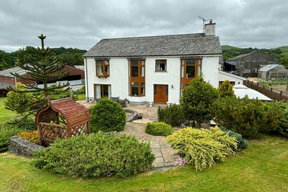
- Price
- Guide Price£748,500
- Size
- 18 acres
Crugybar, Llanwrda, SA19, Cynwyl Gaeo, Carmarthenshire SA19 Wales
Added on 25/09/2026Smallholding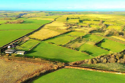
- Price
- £550,000
- Size
- 15.2 acres
Cwrtnewydd, Llanybydder, SA40, Llanwenog, Ceredigion SA40 Wales
Added on 06/02/2026Smallholding