Landulph, Near Saltash
- Land size
- 2.25 acres
- Bedrooms
- 4
- Bathrooms
- 2
Key Features
- NO ONWARD CHAIN
Description
NO ONWARD CHAIN - IMMENSELY PRETTY COTTAGE WITH ANNEXE AND 2 ACRE PADDOCK.
NO ONWARD CHAIN - THE BEAUTIFUL TAMAR VALLEY - An immensely pretty and south facing detached cottage with annexe, stabling, orchard and paddock, in a prized location only 400 yards from the tidal waters of Kingsmill Lake. About 1730 sq ft, 15' Sitting Room with wood burner, 27' Bespoke Kitchen/Dining/Family Room, Snug/Bedroom 4, Boot Room with Dog Wash, 3 Bedrooms (1 Ensuite), Shower Room/WC, 645 sq ft 1 Bed Annexe, Stabling for 3, Field Shelters and Log Store, Gardens and Parking, Solar PV and Battery System, About 2.25 Acres.
CARGREEN YACHT CLUB 0.75 MILE, SALTASH 5 MILES, PLYMOUTH 12 MILES, WHITSAND BAY BEACHES 14 MILES, FOWEY 29 MILES, EXETER 55 MILES
Description - Church Cottage comprises a detached south facing cottage in a prized location on the truly unspoilt Landulph Peninsula. The property successfully blends classic architecture, well proportioned internal accommodation and a mix of contemporary and character features, including a fabulous bespoke kitchen by Arrital, and a solar pv/10kw battery system, to provide a comfortable home which is well suited to family life and the outdoor lifestyle. In addition the property benefits from a detached 1 bedroom annexe (for non-paying guests or family) together with stabling and paddock.
The cottage has the benefit of being almost fully double glazed (many of the windows are bespoke by Rawlings Joinery), oil fired central heating (one boiler serves cottage and annexe) and a private borehole water supply with filtration system.
Church Cottage extends to about 1730 sq ft and briefly comprises - GROUND FLOOR - Reception Hall with slate flag floor - Cloakroom/WC - 15' Snug/Bedroom 4 - 15' Sitting Room with wood burner - 27' Kitchen with bespoke fitted kitchen by Arrital having Smeg appliances and Quooker tap, wide opening to the Dining/Family Room having oak framed windows with fabulous views - Boot Room with dog wash strategically located for rinsing off after a country walk - FIRST FLOOR - Superb 15' Principal Bedroom Suite with Ensuite Bathroom having a feature freestanding bath - 2 Further Double Bedrooms - 10' Shower Room/WC.
Church Cottage Annexe - classified as ancillary accommodation for family or non-paying guests, the annexe extends to about 645 sq ft and briefly comprises - GROUND FLOOR - 26' Living Room with oak floor, wood burner and French doors to the garden - Large Shower Room/WC in the wet room style - Generous Double Bedroom with oak floor, wardrobes and Juliet balcony. NOTE - The annexe benefits from planning permission for a first floor extension.
Outside - The property is approached over a private drive providing ample off road parking with space for motorhome, caravan, horsebox or boat etc. The annexe also has private parking. A concrete yard leads to the stable block with three boxes, canopy providing shelter and light, power and water connected. Further outbuildings include two field shelters, an outside bar/entertainment area with log store adjacent. The cottage has a south aspect with a large brick and slate paved patio having fine views towards Kingsmill Lake, beyond the patio there are lawned gardens with various tree, shrub and flower beds. The garden curtilage extends to about 0.25 acre and backs onto natural woodland with wildlife in abundance.
The paddock extends to just under 2 acres divided into grazing suitable for horses and smallholding, the other section is laid out as a productive orchard and kitchen garden with raised beds.
Location - Church Cottage lies in an enviable and exclusive setting, only 400 yards from the tidal waters edge of Kingsmill Lake leading onto the Tamar River/Estuary with the sheltered waters of Plymouth Sound only 6 miles south by boat.
Landulph has a fascinating history as an emabarkation point for pilgrims visiting the shrine of St James at Compostela de Santiago during the 15th century, there is a beautiful church with Norman origins, a primary school (rated "good" by Ofsted) and a community hall. Closeby Cargreen is a charming riverside village which would have been a hive of activity in Victorian times with the wide and sheltered waters of the River Tamar being used as a busy thoroughfare transporting agricultural goods to Plymouth. Cargreen has a yacht club with deep water moorings available (about £385 to £440 per annum plus membership fees) on the River Tamar.
The Landulph peninsula is one of the regions most scenic positions. The Tamar Valley was granted World Heritage Status in 2006 and is an Area of Outstanding Natural Beauty.
There are delightful walks to be enjoyed around the waterside areas and the countryside of the Tamar Valley. Places of interest locally include Pentillie Castle (the setting for the popular Sky 1 drama, Delicious) with it beautiful gardens and the venue for various events, various National Trust properties including Cothele House, The landmark of The Cheeswring on Bodmin Moor and the wide open spaces of the Dartmoor National Park are within an easy drive.
The waterside town of Saltash, includes a Waitrose store on its northern outskirts. Plymouth is accessible via the A38 and provides a wide range of facilities including a cross channel ferry port and mainline railway station (Plymouth - London Paddington 3hrs).
Nearby St Mellion International Golf Resort offers unique 4-star facilities including an AA luxury hotel, leisure centre, Elemis day spa, tennis courts, a European Tour golf course, a brasserie and an award-winning restaurant. There is a Montessori Nursery at St Germans (8 miles) and independent schools at Tavistock and Plymouth.
Plymouth has a long and historic waterfront together with a mainline railway station (Plymouth to London Paddington 3 hours) and a cross channel ferry port with services to France and Northern Spain. International flights are available from Newquay (40 miles) and Exeter (55 miles). The fabulous harbour side town of Fowey lies 32 miles to the south and the famous surfing beach of Polzeath is within about a 1 hour drive.
Epc Rating - E, Council Tax Band - E - SERVICES - Private borehole water supply with filtration system, electricity and private drainage.
Directions - Using Sat Nav - Postcode PL12 6NG
Map Location
Property details
- Tenure
- Freehold
- Council Tax Band
- Ask Agent
- Date Posted
- 2026-05-29
Market Value Analysis
Compared with 112 Farms & Smallholdings listings in South West England (1+ acres).
Utilities & Restrictions
Utilities
- Electricity
- Ask Agent
- Water
- Ask Agent
- Heating
- Ask Agent
- Broadband
- Ask Agent
- Sewerage
- Ask Agent
Rights & Restrictions
- Public Rights of Way
- Ask Agent
- Private Rights of Way
- Ask Agent
- Listed Property
- Ask Agent
- Restrictions
- Ask Agent
Listed status, conservation areas and planning constraints for this location are in the full report.
Property Features
- Accessibility
- Ask Agent
- Parking
- Parking Available
- Garden
- Garden
Beyond the particulars: planning activity, flood history, heritage and ground risks, checked for this exact spot.
Connectivity
Broadband
Fastest speed available at this postcode
1.8 Gbps
Gigabit full fibre
Suitable for
- 4K streaming on every screen
- Full-time home working
- Online gaming & big downloads
Fixed wireless access may also be an option here.
Mobile signal
Outdoor predictions; indoor signal depends on building materials.
Ofcom Connected Nations postcode-level predictions. Speeds and signal are modelled, not measured, and vary between addresses and providers.
Signal is the easy part. Planning activity, flood history and protected designations here are in the full report.
Nearest Schools
Primary
- Landulph School461 metresOfsted: Good
- Ages
- 4 to 11
- Pupils
- 58
- Type
- Academy converter
- Brunel Primary & Nursery Academy2 milesOfsted: Good
- Ages
- 2 to 11
- Pupils
- 211
- Type
- Academy converter
- Burraton Community Primary School2.2 milesNo Ofsted rating
- Ages
- 4 to 11
- Pupils
- 343
- Type
- Community school
- St Stephens (Saltash) Community Primary School & Nursery2.3 milesNo Ofsted rating
- Ages
- 4 to 11
- Pupils
- 349
- Type
- Community school
- Ernesettle Community School2.3 milesOfsted: Outstanding
- Ages
- 2 to 11
- Pupils
- 587
- Type
- Academy converter
Secondary
- Saltash Community School2.5 milesOfsted: Good *
- Ages
- 11 to 18
- Pupils
- 1,139
- Type
- Academy converter
- Marine Academy Plymouth2.8 milesOfsted: Good
- Ages
- 11 to 18
- Pupils
- 989
- Type
- Academy sponsor led
- Sir John Hunt Community Sports College3.3 milesOfsted: Good
- Ages
- 11 to 19
- Pupils
- 760
- Type
- Foundation school
- All Saints Church of England Academy3.5 milesOfsted: Good
- Ages
- 11 to 16
- Pupils
- 668
- Type
- Academy sponsor led
- Faith
- Church of England
- Notre Dame RC School4 milesOfsted report card · Feb 2026
- Ages
- 11 to 18
- Pupils
- 764
- Type
- Academy converter
- Faith
- Roman Catholic
- Gender
- Girls
* Latest graded judgement covers quality of education only; no overall grade was issued under the 2024-25 inspection framework.
Distances are straight-line from the advertised location. Source: the national school registers (DfE, Welsh Government, Scottish Government) and Ofsted.
Schools are just the start: sold prices nearby, planning activity and any flood history are in the full report.
Amenities
Supermarket
GP surgery
Pharmacy
Hospital
Green space
Straight-line distances from the advertised location. Sources: NHS records, Geolytix supermarket locations, OS Open Greenspace and the national trails registers.
The area stacks up? Now check the location itself: planning nearby, protected designations and past flooding.
Getting Around
Nearest station
Nearest bus stop
Typical drive times
Straight-line distances from the advertised location; drive times are typical free-flow times over OpenStreetMap road data, so allow more at peak. Public transport locations from DfT NaPTAN.
Easy to reach matters. So do planning activity, flood history and ground risks: all in the full report.
Flood Risk
From Environment Agency flood map open data, checked around the advertised map pin and allowing for the listed acreage where known. This summary comes from LandSale, the advertising platform, not from the listing agent, and is not part of the agent's particulars. Risk can vary across a single holding, so verify anything critical through your own searches before committing.
Rivers and the sea
Surface water
The detail behind these bandings
The full report pinpoints where this location sits on the flood maps, and runs the deeper checks that usually only surface after an offer.
- Exact flood zones & annual chances (included in the full report)
- Any recorded past flooding (included in the full report)
- Planning activity nearby (included in the full report)
- Heritage & conservation (included in the full report)
- Protected nature designations (included in the full report)
- Ground risks (included in the full report)
- Sold prices nearby (included in the full report)
£14.99 · one-off purchase
By LandSale, the platform. Not provided by the listing agent. Ready in about a minute.
Important notice: Information, maps and tags on this page are drawn from the advertising agent's marketing materials or generated automatically. LandSale has not verified them. Relying on these details is at your own risk, always carry out independent checks before committing to a purchase.
LandSale full disclaimer
Marketing information only - not formal particulars. The details on this website are provided for general guidance and do not constitute an offer or contract. Neither LandSale nor the advertising estate/land agent accepts responsibility for any inaccuracy.
1. Source of information
- Listing content: Core description, asking price, tenure, measurements, photographs and planning history originate from the marketing materials of the advertising estate or land agent. LandSale does not author this content and cannot guarantee its accuracy.
- Automated tags & categorisation: Property type, land-use class, acreage bands and similar labels may be applied by machine-learning models. They are intended as a helpful guide only and may not reflect the property's legal status or permitted use.
- Third-party & enriched data layers: Maps, boundary outlines, planning designations, soil reports, broadband coverage and other environmental or location-based insights are licensed from external suppliers. Such data are supplied “as is", may be incomplete or out of date and are subject to change without notice.
2. Verification required
Prospective purchasers must verify critical matters, including but not limited to planning permission, title boundaries, public rights of way, environmental constraints, acreage, services, access and VAT status, through their own inspections, specialist surveys, legal advisers and the selling agent before relying on the information or entering into any contract.
3. No warranty or liability
LandSale gives no warranty, express or implied, as to the accuracy, completeness or fitness for any particular purpose of the information displayed. LandSale shall not be liable for any loss, damage, cost or expense arising directly or indirectly from any use of or reliance on such information, save where liability may not be excluded by law.
4. Updates & feedback
If you believe any detail on this listing is inaccurate, please let us know. We will investigate and, where appropriate, update the listing or notify the agent.
© LandSale | Version 1.3 - August 2026
Listing agent
Scott Parry Associates, Cornwall
TAMAR VIEW NURSERIES Carkeel, Saltash, PL12 6PH
Contact Scott Parry Associates, Cornwall
TAMAR VIEW NURSERIES Carkeel, Saltash, PL12 6PH
View agent profileSimilar properties for sale
- Price
- Offers in Region of£650,000
- Size
- 2.25 acres
Added on 29/01/2026House with Land
- Price
- Guide Price£525,000
- Size
- 6 acres
Added on 17/03/2026Smallholding
- Price
- Guide Price£775,000
- Size
- 27.67 acres
Bratton Clovelly, Okehampton, EX20, Bratton Clovelly, Devon EX20 England
Added on 15/07/2026Smallholding
- Price
- Guide Price£695,000
- Size
- 3.12 acres
Added on 04/08/2026Smallholding
- Price
- Guide Price£700,000
- Size
- 12.15 acres
12.15 Acres - Bow, Crediton, Devon, EX17, Bow, Devon EX17 England
Added on 21/07/2026Farm
- Price
- Guide Price£677,000
- Size
- 9 acres
Shebbear, Beaworthy, Devon, EX21, Shebbear, Devon EX21 England
Added on 24/04/2026Farmhouse
- Price
- Offers in Region of£680,000
- Size
- 3.15 acres
Added on 20/07/2026Smallholding
- Price
- £650,000
- Size
- 3 acres
Buckland Brewer, Bideford, Devon, Buckland Brewer, Devon EX39 England
Added on 27/06/2026Barn Conversion
- Price
- Guide Price£695,000
- Size
- 7.2 acres
Roborough, Winkleigh, Devon, EX19, Roborough, Devon EX19 England
Added on 13/08/2026Smallholding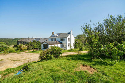
- Price
- Guide Price£775,000
- Size
- 5.73 acres
Added on 09/06/2026Farmhouse