Aychley, Market Drayton, Shropshire
- Land size
- 84.19 acres
Description
A unique opportunity to acquire 84.19 acres of highly productive and Versatile agricultural land set within the rural and picturesque Shropshire Countryside yet within easy reach of the trunk roads leading to major county towns.
84.19 Acres Pasture/Arable
Situated to the north and adjacent to the A41 dual carriageway at Aychley Farm. The land extends to 84.19 acres (34.07 ha) or thereabouts within a ring fence and showing a partial Internal hedge line. Three separate access points are available, two off Moreton Saye Lane and a further access directly of the A41 dual carriageway. The land is well drained and associated within the Newport Soil Series. From visual inspection it would appear to be highly productive. No services are connected but it is believed that electricity and mains water are adjacent. The land is currently growing a medium term grass ley but has been used for arable cropping over many years. The cropping schedule as follows: - Sheet No NG No Acres SJ6134 1656/5137 84.19 (34.07 ha) 2026 Mid Term Ley 2025 Mid Term Ley 2024 Mid Term Ley 2023 Winter Barley 2022 Winter Barley 2021 Winter Wheat FOR SALE BY INFORMAL TENDER TENDERS CLOSE FRIDAY 22nd MAY 2026 AT 12 NOON Sole (truncated)
GENERAL REMARKS AND STIPULATIONS
SITUATION
The land is situated north and adjacent to the A41 dual carriageway adjacent to Aychley Farm, Market Drayton, Shropshire, TF9 3SA. Some 3 miles west of Market Drayton and 8 miles south of Whitchurch.
TENURE
Freehold
POSSESSION
Vacant possession on completion
INGOING
No ingoing
Overage/Uplift
None
SPORTING RIGHTS
The Sporting Rights are included in the sale of all lots.
TIMBER & MINERAL RIGHTS
All growing timber and mineral rights are included in the sale.
BROADBAND / MOBILE TELEPHONES
Potential purchasers should contact “Ofcom Checker” if they require the Broadband provider and mobile phone signal.
FLOODING
The land is not prone to flooding.
BASIC PAYMENT SCHEME
De-Linked Payments will be retained by the vendor.
SERVICES
None Although it is believed that electric and mains water lie adjacent to the land.
LOCAL AUTHORITIES
Shropshire County Council tel:
PLANS, AREAS AND SCHEDULES
These are based on the Ordnance Survey and Rural Land Register or Landscape and are for reference only. They have been checked and computed by the agents and the purchaser shall be deemed to have satisfied him or herself as to the description of the property and any error or mis-statement shall not annul the sale, nor entitle either party to compensation. The plan is for purposes of identification only and is based on the Ordnance Survey Sheets.
PLANNING
The land is sold subject to any development plan , tree preservation order, town planning schedule, resolution or Notice which may be or become to be in force, and subject to any road widening or improvement schemes, land charges and statutory provisions or by-laws without any obligation on the vendors who specify them.
BOUNDARIES
The purchaser shall be deemed to have full knowledge of all boundaries and neither the vendor nor the vendors agents will be responsible for defining the boundaries of ownership thereof.
WAYLEAVES, EASEMENTS AND RIGHTS OF WAY
The property is sold subject to, and with the benefit of, all easements and quasi-easements and rights of way, declared and undeclared.
MISREPRESENTATION ACT
a) The property is sold with all faults and defects (if any) whether in good condition or otherwise and neither the vendors nor McCartneys, the agents for the vendors, shall be in any way responsible for such faults and defects, or for any statements contained in the particulars of the property prepared by the said agents. b) The purchaser shall be deemed to acknowledge that he has not entered in to this contract in reliance on any of the said statements by inspection or otherwise, and that no warranty or representation has been made by the vendors or the said agents in relation to or in connection with the property. c) Any error, omission or mis-statement in any of the said statements shall not entitle the purchaser to rescind or to be discharged from this contract, nor give either party any cause for action. d) All measurements and distances are approximate. The electrical, drainage, water and heating installations have not been tested by the Agents (The normal (truncated)
ENVIRONMENTAL ISSUES
A detailed inspection and assessment of materials that may contain asbestos has not been carried out by the selling agents. Although a general reference to this material may have been made, we cannot confirm whether any of the buildings are constructed of other asbestos based materials, which may be visible, inaccessible or concealed. Prospective purchasers are advised to obtain their own specialist report in relation to this matter and other environmental issues. Asbestos is considered to be a hazardous material and should only be removed and disposed of by an approved contractor. Full de-tails of regulations regarding asbestos and asbestos products can be obtained from the Environmental Health Department of the Local Authority.
HEALTH AND SAFETY
The Agents advise all prospective purchasers when viewing the land to take due care and wear appropriate footwear.
METHOD OF SALE
The land is offered for sale as by Informal Tender. Tenders are to be received in writing at the Agents offices, Worcester on the prepared documentation no later than midday on Friday 22nd May 2026. Offers by email are not acceptable. Envelopes to be marked “Private and Confidential” The Vendors reserve the right not to accept the highest or indeed any offers.
DEPOSIT
A 10% deposit of the sale price will be required on the signing of the contract on 3rd July 2026.
COMPLETION
Completion of the land will take place on:- 29th September 2026 The land is currently let, vacant possession will be available on this date.
VIEWING
The land can be viewed during any day light hours and must be accompanied by the sale particulars.
SPECIAL CONDITIONS
1. The gateway off Moreton Saye Lane marked ‘A’ on the plan must be closed off on completion and not used for access at any time. 2. No buildings are allowed to be erected within the hatched area on the enclosed plan. Buildings can be erected outside this area. 3. No poultry or pig enterprises of any description can be operated on any of the land. These conditions are for perpetuity.
Map Location
Property details
- Tenure
- Ask Agent
- Council Tax Band
- TBC
- Date Posted
- 2026-04-15
Utilities & Restrictions
Utilities
- Electricity
- Ask Agent
- Water
- Ask Agent
- Heating
- Ask Agent
- Broadband
- Ask Agent
- Sewerage
- Ask Agent
Rights & Restrictions
- Public Rights of Way
- Ask Agent
- Private Rights of Way
- Ask Agent
- Listed Property
- Ask Agent
- Restrictions
- Ask Agent
Listed status, conservation areas and planning constraints for this location are in the full report.
Property Features
- Accessibility
- Ask Agent
- Parking
- Ask Agent
- Garden
- Ask Agent
Beyond the particulars: planning activity, flood history, heritage and ground risks, checked for this exact spot.
Connectivity
Broadband
Fastest speed available at this postcode
12 Mbps
Standard (10-30 Mbps)
Suitable for
- Web & social
- Music streaming
- Standard video calls
Fixed wireless access may also be an option here.
Mobile signal
Predicted 4G and 5G signal; indoor signal depends on building materials.
Ofcom Connected Nations postcode-level predictions. Speeds and signal are modelled, not measured, and vary between addresses and providers.
Signal is the easy part. Planning activity, flood history and protected designations here are in the full report.
Nearest Schools
Primary
- Moreton Say CofE Primary School1.1 milesOfsted: Good
- Ages
- 2 to 11
- Pupils
- 111
- Type
- Voluntary controlled school
- Faith
- Church of England
- Lower Heath CofE Primary School2.6 milesOfsted: Good
- Ages
- 2 to 11
- Pupils
- 105
- Type
- Academy converter
- Faith
- Church of England
- Buntingsdale Primary School and Nursery2.9 milesNo Ofsted rating
- Ages
- 3 to 11
- Pupils
- 76
- Type
- Community school
- Market Drayton Junior School3.4 milesNo Ofsted rating
- Ages
- 7 to 11
- Pupils
- 333
- Type
- Academy converter
- Prees CofE Primary School3.5 milesNo Ofsted rating
- Ages
- 2 to 11
- Pupils
- 194
- Type
- Academy converter
- Faith
- Church of England
Secondary
- The Grove School4.2 milesOfsted: Requires improvement
- Ages
- 11 to 18
- Pupils
- 856
- Type
- Academy converter
- Sir John Talbot's School5.4 milesOfsted: Good
- Ages
- 11 to 19
- Pupils
- 861
- Type
- Academy sponsor led
- The Thomas Adams School7.1 milesOfsted: Good
- Ages
- 11 to 18
- Pupils
- 1,214
- Type
- Academy converter
- Brine Leas School11 milesNo Ofsted rating
- Ages
- 11 to 18
- Pupils
- 1,417
- Type
- Academy converter
- Malbank School and Sixth Form College11 milesOfsted: Good
- Ages
- 11 to 18
- Pupils
- 1,289
- Type
- Academy converter
Distances are straight-line from the advertised location. Source: the national school registers (DfE, Welsh Government, Scottish Government) and Ofsted.
Schools are just the start: sold prices nearby, planning activity and any flood history are in the full report.
Amenities
Supermarket
GP surgery
Pharmacy
Hospital
Straight-line distances from the advertised location. Sources: NHS records, Geolytix supermarket locations, OS Open Greenspace and the national trails registers.
The area stacks up? Now check the location itself: planning nearby, protected designations and past flooding.
Getting Around
Nearest station
Nearest bus stop
Typical drive times
Straight-line distances from the advertised location; drive times are typical free-flow times over OpenStreetMap road data, so allow more at peak. Public transport locations from DfT NaPTAN.
Easy to reach matters. So do planning activity, flood history and ground risks: all in the full report.
Flood Risk
Environment Agency open data, checked around the advertised map pin for the listed acreage. Long-term risk counts flood defences; the planning map's flood zones do not. Provided by LandSale, not the listing agent, and not part of the agent's particulars. Risk varies across a holding, so verify before committing.
Rivers and the sea
Planning map: Flood Zone 1.
Surface water
Not at the pin: mapped about 150 metres away.
These bandings are the summary. Where this location sits on the flood maps, plus planning activity, heritage and ground risks, is in the full report.
Important notice: Information, maps and tags on this page are drawn from the advertising agent's marketing materials or generated automatically. LandSale has not verified them. Relying on these details is at your own risk, always carry out independent checks before committing to a purchase.
LandSale full disclaimer
Marketing information only - not formal particulars. The details on this website are provided for general guidance and do not constitute an offer or contract. Neither LandSale nor the advertising estate/land agent accepts responsibility for any inaccuracy.
1. Source of information
- Listing content: Core description, asking price, tenure, measurements, photographs and planning history originate from the marketing materials of the advertising estate or land agent. LandSale does not author this content and cannot guarantee its accuracy.
- Automated tags & categorisation: Property type, land-use class, acreage bands and similar labels may be applied by machine-learning models. They are intended as a helpful guide only and may not reflect the property's legal status or permitted use.
- Third-party & enriched data layers: Maps, boundary outlines, planning designations, soil reports, broadband coverage and other environmental or location-based insights are licensed from external suppliers. Such data are supplied “as is", may be incomplete or out of date and are subject to change without notice.
2. Verification required
Prospective purchasers must verify critical matters, including but not limited to planning permission, title boundaries, public rights of way, environmental constraints, acreage, services, access and VAT status, through their own inspections, specialist surveys, legal advisers and the selling agent before relying on the information or entering into any contract.
3. No warranty or liability
LandSale gives no warranty, express or implied, as to the accuracy, completeness or fitness for any particular purpose of the information displayed. LandSale shall not be liable for any loss, damage, cost or expense arising directly or indirectly from any use of or reliance on such information, save where liability may not be excluded by law.
4. Updates & feedback
If you believe any detail on this listing is inaccurate, please let us know. We will investigate and, where appropriate, update the listing or notify the agent.
© LandSale | Version 1.3 - August 2026
Listing agent
McCartneys LLP, Worcester Market
The Cattle Market, Nunnery Way SY7 9NE
Similar properties for sale
- Price
- £2,500,000
- Size
- 154.88 acres
Land at Fairoak Grange Farm, Eccleshall, Eccleshall, Staffordshire TF9 England
Added on 29/01/2026Arable Land
- Price
- Guide Price£875,000
- Size
- 62.3 acres
Cadney Lane, Bettisfield, Whitchurch., Maelor South, Wrexham SY13 Wales
Added on 05/06/2026Arable Land
- Price
- Guide Price£1,375,000
- Size
- 52.14 acres
Bings Heath, Astley, Shrewsbury, Shawbury, Shropshire SY4 England
Added on 21/07/2026Development Land
- Price
- Guide Price£1,375,000
- Size
- 52.14 acres
Oakwood Grange, Bings Heath, Astley, Shropshire, SY4, Shawbury, Shropshire SY4 England
Added on 20/07/2026Farm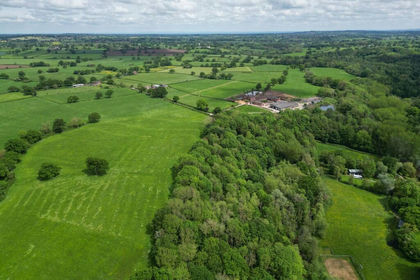
- Price
- Guide Price£275,000
- Size
- 54.47 acres
Wych Brook Woodlands, Malpas, Cheshire (Lot 2), Malpas, Cheshire West and Chester SY14 England
Added on 13/05/2026Agricultural Land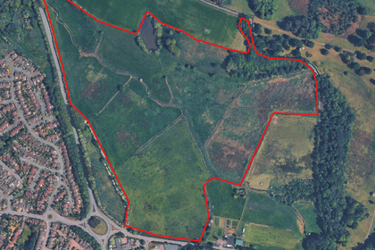
- Price
- POA
- Size
- 66.52 acres
Land at the East of Newport, Newport, Shropshire TF10, Newport, Telford and Wrekin TF10 England
Added on 18/07/2026Vacant Land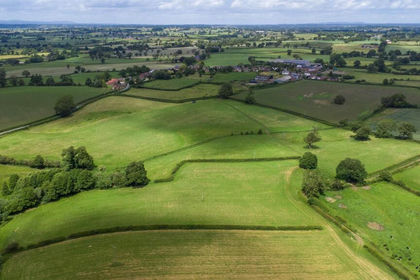
- Price
- £1,050,000
- Size
- 107.08 acres
Land at White House Farm, Weston Lullingfields, Shrewsbury, Baschurch, Shropshire SY4 England
Added on 11/07/2026Agricultural Land
- Price
- Guide Price£800,000
- Size
- 67.78 acres
Land at Tetchill, Ellesmere Road, SY12 9AW (Lots 1 & 2), Ellesmere Rural, Shropshire SY12 England
Added on 29/01/2026Farmland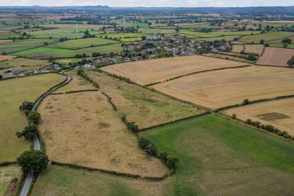
- Price
- £120,000
- Size
- 67.78 acres
Land at Tetchill (Lot 1), Ellesmere, SY12, Ellesmere Rural, Shropshire SY12 England
Added on 29/01/2026Farmland- Price
- Guide Price£680,000
- Size
- 67.78 acres
Land at Tetchill (Lot 2), Ellesmere, SY12, Ellesmere Rural, Shropshire SY12 England
Added on 29/01/2026Farmland