Land at Tetchill, Ellesmere Road, SY12 9AW (Lots 1 & 2)
- Land size
- 61.3 acres
Description
The sale of this land is a unique opportunity to purchase a useful block of agricultural land close to the town of Ellesmere. The land totals 61.3 Acres (24.81 Ha) and is available as a whole or in two lots. The majority of the land is in arable rotation with a portion in grass, but it would be equally suited for growing combinable crops, grazing or mowing.
The land is described as comprising freely draining slightly acidic sandy soils on the Soil Survey of England & Wales.
Lot 1 (shaded blue)
9.45 Acres (3.82 Ha) in permanent pasture, the land is divided by mature hedgerows and the western boundary is formed by the Tetchill Brook which creates an attractive landscape that supports a diverse range of wildlife, adding ecological value. The external boundaries are well-fenced, in the main with mature hedging and sheep wire.
Lot 2 (shaded yellow)
51.85 Acres (20.98 Ha), currently wheat stubble. The Lot is made up of three fields which are divided by mature hedgerows. The eastern boundary is formed by Tetchill Brook.
Additional Land
The area marked with blue chevrons on the attached plan will be retained by the seller, however it will be available for the relevant buyers to rent on an FBT at an appropriate market rent.
Rights of Way and Easements
Lot 1 has direct access from the Tetchill to Ellesmere Road. Access to Lot 2 is via a right of way indicated by the green line on the attached plan. This route is not currently delineated but it follows the hedgerow from the roadside to Lot 2. The sellers will also reserve a right of way over this track to access retained land.
The mains sewer, running from Tetchill to Ellesmere, crosses Lot 1.
The property is sold subject to and with the benefit of all rights including rights of way, whether public or private, light, support, drainage, water, telephone and electricity supplies and other rights and obligations, easements, quasi-easements and restrictive covenants, and all existing and proposed wayleaves or masts, pylons, stays, cable, drains and water, gas or other pipes, whether referred to in the Sales Particulars or not, and to the provisions of any Planning Scheme or County or Local Authorities without obligations on the part of the Sellers or their agents to specify them.
Nitrate Vulnerable Zone
The land is located within the Nitrate Vulnerable Zone as designated by DEFRA.
Services
No mains services are currently connected. There is access to Tetchill Brook from Lot 1 to allow stock to access water.
We are advised that the above services are available. Barbers Rural have not tested any apparatus, equipment, fittings etc or services to this property so cannot confirm that they are in working order. A buyer is recommended to obtain confirmation from their solicitor or surveyor.
For further information please contact the selling Agents.
Map Location
Property details
- Tenure
- Ask Agent
- Council Tax Band
- Ask Agent
- Date Posted
- 2026-01-29
Market Value Analysis
Compared with 26 Farmland & Pasture listings in West Midlands (50+ acres).
Utilities & Restrictions
Utilities
- Electricity
- Ask Agent
- Water
- Ask Agent
- Heating
- Ask Agent
- Broadband
- Ask Agent
- Sewerage
- Ask Agent
Rights & Restrictions
- Public Rights of Way
- Ask Agent
- Private Rights of Way
- Ask Agent
- Listed Property
- Ask Agent
- Restrictions
- Ask Agent
Property Features
- Accessibility
- Ask Agent
- Parking
- Ask Agent
- Garden
- Ask Agent
Important notice: Information, maps and tags on this page are supplied by the advertising agent or generated automatically. LandSale has not verified them. Relying on these details is at your own risk, always carry out independent checks before committing to a purchase.
LandSale full disclaimer
Marketing information only - not formal particulars. The details on this website are provided for general guidance and do not constitute an offer or contract. Neither LandSale nor the advertising estate/land agent accepts responsibility for any inaccuracy.
1. Source of information
- Agent-supplied content: Core description, asking price, tenure, measurements, photographs and planning history are uploaded by the appointed agent, who remains solely responsible for their accuracy.
- Automated tags & categorisation: Property type, land-use class, acreage bands and similar labels may be applied by machine-learning models. They are intended as a helpful guide only and may not reflect the property's legal status or permitted use.
- Third-party & enriched data layers: Maps, boundary outlines, planning designations, soil reports, broadband coverage and other environmental or location-based insights are licensed from external suppliers. Such data are supplied “as is", may be incomplete or out of date and are subject to change without notice.
2. Verification required
Prospective purchasers must verify critical matters, including but not limited to planning permission, title boundaries, public rights of way, environmental constraints, acreage, services, access and VAT status, through their own inspections, specialist surveys, legal advisers and the selling agent before relying on the information or entering into any contract.
3. No warranty or liability
LandSale gives no warranty, express or implied, as to the accuracy, completeness or fitness for any particular purpose of the information displayed. LandSale shall not be liable for any loss, damage, cost or expense arising directly or indirectly from any use of or reliance on such information, save where liability may not be excluded by law.
4. Updates & feedback
If you believe any detail on this listing is inaccurate, please let us know. We will investigate and, where appropriate, update the listing or notify the agent.
© LandSale | Version 1.2 - January 2026
Listing agent
Barbers Rural Consultancy LLP, Market Drayton
Smithfield House Smithfield Road Market Drayton TF9 1EW
Contact Barbers Rural Consultancy LLP, Market Drayton
Smithfield House Smithfield Road Market Drayton TF9 1EW
View agent profileSimilar properties for sale

- Price
- Guide Price£620,000
- Size
- 61.3 acres
Land at Tetchill (Lot 2), Ellesmere, SY12 9AW, Ellesmere Rural, Shropshire SY12 9AP England
Added on 29/01/2026Agricultural Land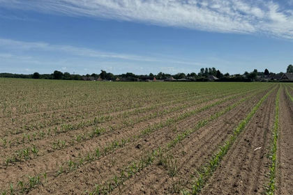
- Price
- Guide Price£875,000
- Size
- 62.3 acres
Cadney Lane, Bettisfield, Whitchurch., Maelor South, Wrexham SY13 2LP Wales
Added on 05/06/2026Arable Land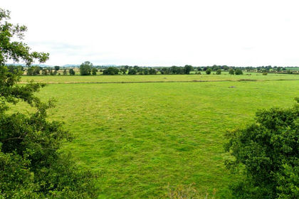
- Price
- Guide Price£672,000
- Size
- 84 acres
Added on 29/01/2026Grazing Land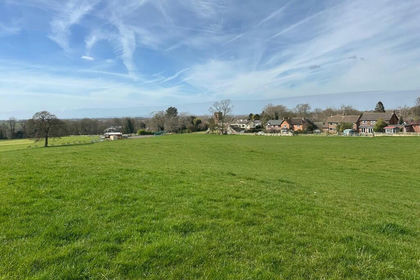
- Price
- Guide Price£635,000
- Size
- 35.09 acres
Land adjoining Betley Court Farm, Betley, Staffordshire CW3 9BH England
Added on 29/01/2026Farmland
- Price
- Guide Price£575,000
- Size
- 47.77 acres
Land known as Land at Cwm Meadows, Churchstoke, Churchstoke, Powys SY15 6TH Wales
Added on 20/03/2026Grazing Land
- Price
- Guide Price£650,000
- Size
- 36.2 acres
Added on 29/01/2026Agricultural Land