Meadow Farm, Charlcombe, Bath, Somerset, BA1
- Land size
- 5 acres
- Bedrooms
- 5
- Bathrooms
- 3
Description
A superb combination of city and country living, The Ranch House is a detached house set in approx 5 acres of paddocks and gardens with a separate one bedroom cottage, situated less than 2 miles from Bath city centre. The property wraps around a southerly-facing 10m x 5m swimming pool with an elevated paved patio area overlooking the picturesque Swainswick Valley. The house itself is mostly single storey built onto the slope of the plot with just a couple of rooms downstairs. The accommodation comprises a Large Kitchen/Breakfast room which provides the hub of the house and has 5m Bi Fold doors leading out to the swimming pool area. The West wing comprises two double bedrooms, a master suite with en suite shower room and a family bathroom. To the rear of the house there is a large family room which has been used as TV room or bedroom in the past and leads into the rear lobby and on to a Study/office. Off the main corridor there is a large cloakroom with a w.c. and a Utility room with a door to the rear of the house. At the eastern side of the house there is a Living room which due to the slope in the land is in an elevated position with windows looking straight across the grounds toward Solsbury Hill. Underneath the Living room there is another double bedroom with an en suite shower room and access to outside.
Outside
The 10m x 5m swimming pool has been recently refurbished. It is surrounded by an Indian Sandstone paved sun deck and has been fitted with an air-source heat pump, it is a real suntrap and due to its elevated position has spectacular views across the valley.
There is a large outbuilding (formerly stables) to the front of the property which has now been repurposed as a playroom, a workshop and a home office/gym.
The grounds (approximately 5 acres) are mostly paddock land with post and rail fencing. There is a lawned area flanking the driveway up to the house and a flat play area. A brook runs around the lower boundary of the property and there is an old sheep shelter which is a versatile building on the Northern boundary which has a power and water supply.
Cottage
The cottage which is situated behind the main house has been completely refurbished by the current owner. It has one large double bedroom with separate ensuite shower room and separate Cloakroom/w.c., Large open plan living space which also contains the kitchen, Utility room and storage room. It also has its own garden and patio area behind the cottage.
Local Authority
Bath & Northeast Somerset Council.
All Mains services are connected.
TENURE Freehold
Main House Council Tax F
Cottage Council Tax A
Broadband Both standard and superfast broadband are available at the property although applicants should check it is suitable for the requirements
Viewing strictly by appointment with the agents.
Mobile Signal: Outdoor & variable indoor coverage across major network providers. Applicants are encouraged to check coverage with their own chosen provider.
Location:
Meadow Farm is situated near Larkhall in an area of outstanding natural beauty at the base of the Charlcombe valley with panoramic views across to the Swainswick Valley. There are local shops (including an award winning butcher and Deli) about a 10 minute walk away and Bath city centre is approx 30 mins level walk away. Bath is a UNESCO World Heritage Site bursting with magnificent architecture, entertainment, fine dining and of course the famous Bath Rec home to Bath Rugby.
Directions:
Directions
From Bath centre take the A4 London Road heading East and just after passing Kwik Fit, at the lights, take a left fork into St Saviour’s Road. Follow this road past Larkhall square and the Larkhall Inn, past the Bladud’s Head pub and take the next left turn into Valley View Road where you will see a gated entrance on the right hand side. The property is accessed through the gated entrance and straight up the driveway to the parking area in front of the house.
Map Location
Property details
- Tenure
- Freehold
- Council Tax Band
- TBC
- Date Posted
- 2026-03-28
Market Value Analysis
Compared with 515 Homes with Land listings in South West England (5+ acres).
Utilities & Restrictions
Utilities
- Electricity
- Ask Agent
- Water
- Ask Agent
- Heating
- Ask Agent
- Broadband
- Ask Agent
- Sewerage
- Ask Agent
Rights & Restrictions
- Public Rights of Way
- Ask Agent
- Private Rights of Way
- Ask Agent
- Listed Property
- Ask Agent
- Restrictions
- Ask Agent
Listed status, conservation areas and planning constraints for this location are in the full report.
Property Features
- Accessibility
- Ask Agent
- Parking
- Parking Available
- Garden
- Garden
Beyond the particulars: planning activity, flood history, heritage and ground risks, checked for this exact spot.
Connectivity
Broadband
Fastest speed available at this postcode
80 Mbps
Superfast
Suitable for
- HD streaming
- Video calls
- Web & social
Mobile signal
Outdoor predictions; indoor signal depends on building materials.
Ofcom Connected Nations postcode-level predictions. Speeds and signal are modelled, not measured, and vary between addresses and providers.
Signal is the easy part. Planning activity, flood history and protected designations here are in the full report.
Nearest Schools
Primary
- St Saviours Junior Church School540 metresNo Ofsted rating
- Ages
- 7 to 11
- Pupils
- 150
- Type
- Academy converter
- Faith
- Church of England
- St Saviours Infant Church School569 metresOfsted: Good
- Ages
- 3 to 7
- Pupils
- 115
- Type
- Academy converter
- Faith
- Church of England
- Swainswick Church School0.8 milesOfsted: Outstanding
- Ages
- 4 to 11
- Pupils
- 72
- Type
- Academy converter
- Faith
- Church of England
- St Stephens Church School0.9 milesNo Ofsted rating
- Ages
- 4 to 11
- Pupils
- 360
- Type
- Academy converter
- Faith
- Church of England
- Bathwick St Mary Church School1 mileOfsted: Good
- Ages
- 4 to 11
- Pupils
- 220
- Type
- Academy converter
- Faith
- Church of England
Secondary
- St Mark's CofE School613 metresOfsted report card · Mar 2026
- Ages
- 11 to 18
- Pupils
- 259
- Type
- Academy converter
- Faith
- Church of England
- Hayesfield Girls School2.2 milesNo Ofsted rating
- Ages
- 11 to 18
- Pupils
- 1,497
- Type
- Academy converter
- Gender
- Girls
- Beechen Cliff School2.2 milesOfsted: Good
- Ages
- 11 to 18
- Pupils
- 1,232
- Type
- Academy converter
- Gender
- Boys
- Oldfield School2.7 milesOfsted: Good
- Ages
- 11 to 18
- Pupils
- 1,287
- Type
- Academy converter
- Ralph Allen School2.8 milesNo Ofsted rating
- Ages
- 11 to 18
- Pupils
- 1,398
- Type
- Academy converter
Distances are straight-line from the advertised location. Source: the national school registers (DfE, Welsh Government, Scottish Government) and Ofsted.
Schools are just the start: sold prices nearby, planning activity and any flood history are in the full report.
Amenities
Supermarket
GP surgery
Pharmacy
Hospital
Green space
Straight-line distances from the advertised location. Sources: NHS records, Geolytix supermarket locations, OS Open Greenspace and the national trails registers.
The area stacks up? Now check the location itself: planning nearby, protected designations and past flooding.
Getting Around
Nearest station
Nearest bus stop
Typical drive times
Straight-line distances from the advertised location; drive times are typical free-flow times over OpenStreetMap road data, so allow more at peak. Public transport locations from DfT NaPTAN.
Easy to reach matters. So do planning activity, flood history and ground risks: all in the full report.
Flood Risk
From Environment Agency flood map open data, checked around the advertised map pin and allowing for the listed acreage where known. This summary comes from LandSale, the advertising platform, not from the listing agent, and is not part of the agent's particulars. Risk can vary across a single holding, so verify anything critical through your own searches before committing.
Rivers and the sea
Mapped within the area searched, not at the advertised map pin itself.
Surface water
Mapped within the area searched, not at the advertised map pin itself.
The detail behind these bandings
The full report pinpoints where this location sits on the flood maps, and runs the deeper checks that usually only surface after an offer.
- Exact flood zones & annual chances (included in the full report)
- Any recorded past flooding (included in the full report)
- Planning activity nearby (included in the full report)
- Heritage & conservation (included in the full report)
- Protected nature designations (included in the full report)
- Ground risks (included in the full report)
- Sold prices nearby (included in the full report)
£14.99 · one-off purchase
By LandSale, the platform. Not provided by the listing agent. Ready in about a minute.
Important notice: Information, maps and tags on this page are drawn from the advertising agent's marketing materials or generated automatically. LandSale has not verified them. Relying on these details is at your own risk, always carry out independent checks before committing to a purchase.
LandSale full disclaimer
Marketing information only - not formal particulars. The details on this website are provided for general guidance and do not constitute an offer or contract. Neither LandSale nor the advertising estate/land agent accepts responsibility for any inaccuracy.
1. Source of information
- Listing content: Core description, asking price, tenure, measurements, photographs and planning history originate from the marketing materials of the advertising estate or land agent. LandSale does not author this content and cannot guarantee its accuracy.
- Automated tags & categorisation: Property type, land-use class, acreage bands and similar labels may be applied by machine-learning models. They are intended as a helpful guide only and may not reflect the property's legal status or permitted use.
- Third-party & enriched data layers: Maps, boundary outlines, planning designations, soil reports, broadband coverage and other environmental or location-based insights are licensed from external suppliers. Such data are supplied “as is", may be incomplete or out of date and are subject to change without notice.
2. Verification required
Prospective purchasers must verify critical matters, including but not limited to planning permission, title boundaries, public rights of way, environmental constraints, acreage, services, access and VAT status, through their own inspections, specialist surveys, legal advisers and the selling agent before relying on the information or entering into any contract.
3. No warranty or liability
LandSale gives no warranty, express or implied, as to the accuracy, completeness or fitness for any particular purpose of the information displayed. LandSale shall not be liable for any loss, damage, cost or expense arising directly or indirectly from any use of or reliance on such information, save where liability may not be excluded by law.
4. Updates & feedback
If you believe any detail on this listing is inaccurate, please let us know. We will investigate and, where appropriate, update the listing or notify the agent.
© LandSale | Version 1.3 - August 2026
Listing agent
Winkworth, Bath
13 Argyle Street Bath BA2 4BQ
Similar properties for sale
- Price
- Guide Price£2,500,000
- Size
- 5 acres
Friary, Freshford, Bath, BA2, Hinton Charterhouse, Bath and North East Somerset BA2 England
Added on 07/03/2026House with Land
- Price
- £2,650,000
- Size
- 25.6 acres
Gibbs Lane, Siston, Bristol, Siston, South Gloucestershire BS16 England
Added on 31/07/2026Country Estate- Price
- £2,495,000
- Size
- 17.4 acres
Gibbs Lane, Siston, Bristol, Siston, South Gloucestershire BS16 England
Added on 01/08/2026Country Estate
- Price
- Guide Price£1,995,000
- Size
- 37.7 acres
West Yatton, Yatton Keynell, Chippenham, Wiltshire, SN14, Yatton Keynell, Wiltshire SN14 England
Added on 14/05/2026Country Home
- Price
- Guide Price£2,000,000
- Size
- 3.7 acres
Radford, Bath, BA2, Timsbury, Bath and North East Somerset BA2 England
Added on 30/04/2026Farmhouse
- Price
- Guide Price£1,750,000
- Size
- 35 acres
35 acres, Farm Buildings, Whaddon, Trowbridge, BA14, Hilperton, Wiltshire BA14 England
Added on 13/03/2026Farmland
- Price
- Offers in Excess of£2,000,000
- Size
- 3.73 acres
Added on 04/07/2026Holiday Let Property
- Price
- Guide Price£1,800,000
- Size
- 32.74 acres
Bury Hill Lane, Yate, Bristol, Gloucestershire, BS37, Wickwar, South Gloucestershire BS37 England
Added on 29/07/2026House with Land
- Price
- Guide Price£2,000,000
- Size
- 3.3 acres
Added on 26/06/2026House with Land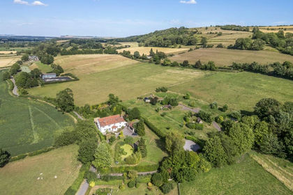
- Price
- Guide Price£1,975,000
- Size
- 30 acres
Farm, 30 acres, glamping, Edington, Westbury, BA13, Edington, Wiltshire BA13 England
Added on 01/08/2026Farmhouse