Farm, 30 acres, glamping, Edington, Westbury, BA13
- Land size
- 30 acres
- Bedrooms
- 5
- Bathrooms
- 4
Key Features
- Attractive farmhouse, extensive buildings, stabling and outdoor arena, set in 30 acres with glamping field.
- Residential, business, smallholding, equestrian and development opportunity.
- Well appointed and spacious farmhouse used recently for boutique style B&B.
- Five bedrooms. Three Reception rooms. Four Bathrooms
- Boutique glamping field
- Extensive range of agricultural buildings. Former poultry buildings.
- 5 Stables and all weather arena
- Edge of popular village. Walking distance from the well-regarded village pub and farm shop.
- Excellent walking and riding on the doorstep
- Close to Frome and Westbury. Good access to Westbury Station
Description
Residential, business, smallholding, equestrian and development opportunity.
Attractive farmhouse, extensive buildings, stabling and outdoor arena, set in 30 acres with glamping field.
An exciting residential, business, smallholding, equestrian and development opportunity set in all just over 30 acres in a glorious rural location, close to the iconic Westbury White Horse and 5 miles from Westbury station.
Slades Farm comprises a well-appointed farmhouse with 5 bedrooms and kitchen/breakfast room adjoining super gardens and grounds with a driveway and garaging. Further land of just under 30 acres adjoins and includes is a beautifully presented glamping field with pods and shepherd’s huts and an immediately adjoining paddock, together with stabling an all-weather school and extensive buildings and farm buildings with potential for other uses. Available as a whole - edged red and blue on the plan. The property sits on the edge of the popular village in walking distance from the well-regarded village pub and farm shop.
The house - edged red on the plan
An attractive and substantial period farmhouse that that has most recently been used as a boutique style bed and breakfast with adjacent successful glamping destination. It has versatile living space that will suit a large family. The entrance porch leads into the inner hall and there are stairs to the first floor. The sitting room has double doors to the front and a woodburning stove set into a red brick chimney breast. On the other side of the hallway is a further reception room with a large red brick fireplace with wood burning stove inset. Double doors lead into the dining room which in turn opens into conservatory. A well-proportioned kitchen and breakfast room provide an extensive range of floor and wall shaker style cabinets finished with a granite worksurface. There is a 1 ½ bowl sink with drainer, a built-in dishwasher, fridge and freezer and an electric Rangemaster cooker. There is also a central island unit and ample space for a breakfast table/seating area. There is a study and a utility room with separate cloakroom. On the first floor there is a spacious and light landing with three en suite bedrooms, two further bedrooms and a family bathroom.
Outside
Attached to the house is a stone storeroom and there is a separate garage, double open garaging and oil store. The gardens are mature and well stocked with trees, borders, a pond and plenty of lawned areas. To the rear of the house is a sheltered and private courtyard area and further lawned area. A paddock of just over 3 acres adjoins the glamping pods and could be used for livestock or amenity uses.
The Farm:
Glamping site
Adjacent to the farmhouse with a separate access the current owners have operated a successful glamping business in conjunction with the house offering bed and breakfast accommodation. There are five beautifully built pods or shepherd huts nestled into the countryside that provide meticulously planned and equipped accommodation. Each pod has a kitchen area, bathroom and bed and provides a private outdoor seating area to enjoy the stunning scenery. The pods are equipped with Wifi and enjoy a stunning setting.
Land and Buildings
Edged blue on the plan - Continue along Baynton Way and there is an extensive range of former poultry and livestock buildings and yard areas that are set at two sites and could suit a multitude of uses, subject to the necessary consent. There are also 5 stables, a hay barn and an all-weather riding arena, currently running a successful livery.
Location
The village of Edington is a small village about 4 miles from Westbury set under the north slopes of the Salisbury Plain and just 3 miles from the famous Westbury White Horse chalk slopes.
There is a lively community with a church, village hall, the award winning 'Three Daggers' pub with farm shop and a busy schedule of WI, parent and toddler, art and gardening groups. The village of Steeple Ashton also enjoys a thriving rural community with a pub, village shop with café, village hall, Brownies, Guides and Rainbows, ballroom dancing, gardening, parent and toddler, WI and exercise groups.
The Bratton Downs which include the White Horse, are a 'site of special scientific interest' and there are a fantastic network of footpaths and open space on the doorstep. Shopping facilities are good with local farm shops, and village stores as well as all the major supermarkets close by including Waitrose, Tesco's, Asda, Sainsburys and Morrisons in the local towns. The cathedral cities of Bath and Salisbury provide a comprehensive range of clothing and high street retail stores. Local primary schools can be found in Bratton, Great Cheverell, Keevil and West Ashton. Excellent private schools can be found in Warminster, Dauntsey's at West Lavington, Stonar at Atworth, Salisbury, Marlborough, Bath and St Mary's at Calne with state schools in Devizes, Warminster, Trowbridge, Bradford on Avon, Melksham and Frome.
Travel connections are good with Westbury train station having regular trains to London, Bath, Bristol, Salisbury, Southampton, Exeter and Taunton.
Riding out from the yard is via a series of country lanes and bridleways. There are some excellent competition and training venues in the area offering both affiliated and unaffiliated competitions catering for all disciplines. There is also a good choice Pony Clubs and Riding Clubs in area including Bath Riding Club, Saxon Dressage Group, Wylye Valley and Avon Vale Pony Clubs.
Agents note
A footpath crosses the land from Baynton Way by the all-weather riding arena diagonally across the land to the corner of the field by Highview House on to Westbury Road.
The land (excluding the gardens) within the area edged in blue is offered for sale subject to an Overage (Uplift) clause. The terms will be 20% of the increased value and will apply for 7 years from the date of a sale
farm-property, equestrian-property, country-property,
Map Location
Property details
- Tenure
- Ask Agent
- Council Tax Band
- Ask Agent
- Date Posted
- 2026-08-01
Market Value Analysis
Compared with 70 Homes with Land listings in South West England (25+ acres).
Energy Performance Certificate
Energy Efficiency Rating
Based on UK Energy Performance Certificate standards (EU Directive 2002/91/EC)
Running costs are one side. Planning activity, flood history and ground risks for this location are in the full report.
Utilities & Restrictions
Utilities
- Electricity
- Ask Agent
- Water
- Ask Agent
- Heating
- Ask Agent
- Broadband
- Ask Agent
- Sewerage
- Ask Agent
Rights & Restrictions
- Public Rights of Way
- Ask Agent
- Private Rights of Way
- Ask Agent
- Listed Property
- Ask Agent
- Restrictions
- Ask Agent
Listed status, conservation areas and planning constraints for this location are in the full report.
Property Features
- Accessibility
- Ask Agent
- Parking
- Parking Available
- Garden
- Garden
Beyond the particulars: planning activity, flood history, heritage and ground risks, checked for this exact spot.
Connectivity
Broadband
Fastest speed available at this postcode
80 Mbps
Superfast
Suitable for
- HD streaming
- Video calls
- Web & social
Mobile signal
Outdoor predictions; indoor signal depends on building materials.
Ofcom Connected Nations postcode-level predictions. Speeds and signal are modelled, not measured, and vary between addresses and providers.
Signal is the easy part. Planning activity, flood history and protected designations here are in the full report.
Nearest Schools
Primary
- Bratton Primary School1.4 milesOfsted: Good
- Ages
- 4 to 11
- Pupils
- 129
- Type
- Community school
- The Holy Trinity Church of England Primary Academy2.8 milesOfsted: Outstanding
- Ages
- 4 to 11
- Pupils
- 150
- Type
- Academy converter
- Faith
- Church of England
- Keevil CofE Primary School3 milesOfsted: Good
- Ages
- 4 to 11
- Pupils
- 87
- Type
- Academy converter
- Faith
- Church of England
- Five Lanes Church of England Primary School3.3 milesOfsted: Requires improvement
- Ages
- 4 to 11
- Pupils
- 47
- Type
- Academy converter
- Faith
- Church of England
- West Ashton Church of England Primary School3.7 milesOfsted: Good
- Ages
- 3 to 11
- Pupils
- 88
- Type
- Academy sponsor led
- Faith
- Church of England
Secondary
- Matravers School4.4 milesOfsted: Good
- Ages
- 11 to 18
- Pupils
- 958
- Type
- Foundation school
- Lavington School4.6 milesNo Ofsted rating
- Ages
- 11 to 18
- Pupils
- 910
- Type
- Academy converter
- Melksham Oak Community School5.6 milesOfsted: Good
- Ages
- 11 to 18
- Pupils
- 1,058
- Type
- Academy converter
- The Clarendon Academy5.7 milesNo Ofsted rating
- Ages
- 11 to 18
- Pupils
- 1,082
- Type
- Academy sponsor led
- The John of Gaunt School6 milesNo Ofsted rating
- Ages
- 11 to 18
- Pupils
- 1,295
- Type
- Academy converter
Distances are straight-line from the advertised location. Source: the national school registers (DfE, Welsh Government, Scottish Government) and Ofsted.
Schools are just the start: sold prices nearby, planning activity and any flood history are in the full report.
Amenities
Supermarket
GP surgery
Pharmacy
Hospital
Green space
Straight-line distances from the advertised location. Sources: NHS records, Geolytix supermarket locations, OS Open Greenspace and the national trails registers.
The area stacks up? Now check the location itself: planning nearby, protected designations and past flooding.
Getting Around
Nearest station
Nearest bus stop
Typical drive times
Straight-line distances from the advertised location; drive times are typical free-flow times over OpenStreetMap road data, so allow more at peak. Public transport locations from DfT NaPTAN.
Easy to reach matters. So do planning activity, flood history and ground risks: all in the full report.
Flood Risk
From Environment Agency flood map open data, checked around the advertised map pin and allowing for the listed acreage where known. This summary comes from LandSale, the advertising platform, not from the listing agent, and is not part of the agent's particulars. Risk can vary across a single holding, so verify anything critical through your own searches before committing.
Rivers and the sea
Surface water
Mapped within the area searched, not at the advertised map pin itself.
These bandings are the summary. Where this location sits on the flood maps, plus planning activity, heritage and ground risks, is in the full report.
Important notice: Information, maps and tags on this page are drawn from the advertising agent's marketing materials or generated automatically. LandSale has not verified them. Relying on these details is at your own risk, always carry out independent checks before committing to a purchase.
LandSale full disclaimer
Marketing information only - not formal particulars. The details on this website are provided for general guidance and do not constitute an offer or contract. Neither LandSale nor the advertising estate/land agent accepts responsibility for any inaccuracy.
1. Source of information
- Listing content: Core description, asking price, tenure, measurements, photographs and planning history originate from the marketing materials of the advertising estate or land agent. LandSale does not author this content and cannot guarantee its accuracy.
- Automated tags & categorisation: Property type, land-use class, acreage bands and similar labels may be applied by machine-learning models. They are intended as a helpful guide only and may not reflect the property's legal status or permitted use.
- Third-party & enriched data layers: Maps, boundary outlines, planning designations, soil reports, broadband coverage and other environmental or location-based insights are licensed from external suppliers. Such data are supplied “as is", may be incomplete or out of date and are subject to change without notice.
2. Verification required
Prospective purchasers must verify critical matters, including but not limited to planning permission, title boundaries, public rights of way, environmental constraints, acreage, services, access and VAT status, through their own inspections, specialist surveys, legal advisers and the selling agent before relying on the information or entering into any contract.
3. No warranty or liability
LandSale gives no warranty, express or implied, as to the accuracy, completeness or fitness for any particular purpose of the information displayed. LandSale shall not be liable for any loss, damage, cost or expense arising directly or indirectly from any use of or reliance on such information, save where liability may not be excluded by law.
4. Updates & feedback
If you believe any detail on this listing is inaccurate, please let us know. We will investigate and, where appropriate, update the listing or notify the agent.
© LandSale | Version 1.3 - August 2026
Listing agent
Cooper and Tanner, Frome
6 The Bridge, Frome, BA11 1AR
Similar properties for sale
- Price
- £1,600,000
- Size
- 23.76 acres
Hisomley, Dilton Marsh, Dilton Marsh, Wiltshire BA13 England
Added on 29/01/2026Equestrian property
- Price
- Guide Price£1,600,000
- Size
- 23.76 acres
Equestrian, 23 acres, Hisomely, Westbury, BA13, Dilton Marsh, Wiltshire BA13 England
Added on 29/01/2026Equestrian property
- Price
- Guide Price£1,750,000
- Size
- 35 acres
35 acres, Farm Buildings, Whaddon, Trowbridge, BA14, Hilperton, Wiltshire BA14 England
Added on 13/03/2026Farmland
- Price
- Guide Price£1,995,000
- Size
- 37.7 acres
West Yatton, Yatton Keynell, Chippenham, Wiltshire, SN14, Yatton Keynell, Wiltshire SN14 England
Added on 14/05/2026Country Home
- Price
- Guide Price£1,950,000
- Size
- 28.98 acres
Stratford Mill, Mill Lane, Stratford Sub Castle, Salisbury, SP1, Salisbury, Wiltshire SP1 England
Added on 31/07/2026House with Land
- Price
- £1,900,000
- Size
- 57.91 acres
Rodgrove, Wincanton, Somerset, BA9, Wincanton, Somerset BA9 England
Added on 30/04/2026Farm
- Price
- Guide Price£1,900,000
- Size
- 57.91 acres
Moor Lane, Rodgrove, Wincanton, Wincanton, Somerset BA9 England
Added on 10/05/2026Farm
- Price
- Guide Price£1,850,000
- Size
- 26.25 acres
Added on 30/05/2026Farmhouse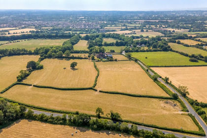
- Price
- Guide Price£1,800,000
- Size
- 32.74 acres
Bury Hill Lane, Yate, Bristol, Gloucestershire, BS37, Wickwar, South Gloucestershire BS37 England
Added on 29/07/2026House with Land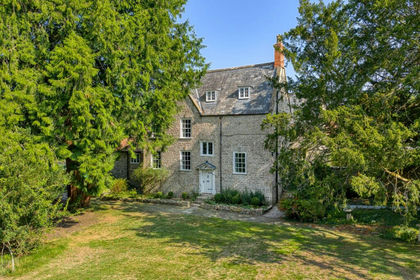
- Price
- Guide Price£2,000,000
- Size
- 25 acres
Manor house with circa 26 acres, a mile from Wells, St Cuthbert Out, Somerset BA5 England
Added on 29/01/2026Country Home