Barn for conversion, Docker Park Farm, Arkholme, Carnforth, LA6
- Land size
- 0.5 acres
Key Features
- Rare opportunity to acquire a substantial traditional barn in attractive rural setting
- Planning consent in place for the creation of two distinctive countryside homes
- Unrestricted occupancy, maximising future flexibility and value
- c. 0.5 acres offering superb potential for landscaping and outdoor living
- Exciting canvas for a high-quality residential development
- Perfect for developers, private buyers, or families wishing to create adjoining homes
- Lune Valley location, handy for Kirkby Lonsdale amenities
Description
The opportunity will suit private buyers keen to have a second dwelling for investment purposes, extended families and developers.
House 1
Ground floor: hall, sitting room, living kitchen, utility room, bedroom 4, shower room.
First floor: ensuite bedroom 1, bedrooms 2 and 3 sharing Jack and Jill style shower room.
House 2
Ground floor: hall, dining room, sitting room, snug, dining kitchen, ensuite bedrooms 1 and 2, bedroom 3, shower room.
First floor: ensuite bedroom 4.
Within the heart of the beautiful Lune Valley, ideal for those seeking a country lifestyle whilst still being readily accessible for amenities, schools and shops in Kirkby Lonsdale and Carnforth.
Location
The barn enjoys a rural setting but has road and rail links within easy reach. Depending on whether you’re travelling north or south the M6 is each to access, J35 is 6.5 miles distant with J36 being 10.9 miles. If catching the train, the main
west coastline has stations at Oxenholme (14.6 miles) and Lancaster (11.8 miles), there is also a station at Carnforth (7.1 miles) on the Bentham and Furness lines. Local schools, shops and services are available at both Kirkby Lonsdale (5.5 miles) and Carnforth (6.7 miles). Offering a wider choice of retail and recreational opportunities are the city of Lancaster (11.2 miles) and Lakes Gateway Town of Kendal (17 miles). The Lune Valley offers a great lifestyle especially for those that love the great outdoors with abundant footpaths, bridlepaths and quiet lanes to explore, whether walking, running or cycling and a super selection of cafes, country pubs and restaurants as well as artisan food producers.
The above journey distances are for approximate guidance only and have been sourced from the fastest route on the AA website from the property postcode.
Planning Permission Specifics
Planning permission was granted by Lancaster City Council on the 30th April 2025 for the change of use of the barn into two dwellings, reference number 24/01028/VCN. Interested parties should visit the planning portal to obtain full information.
The purchaser would need to make their own application for garaging if required.
Directions
what3words areas.chip.seagulls
Use the postcode LA6 1AR on Sat Nav with reference to the directions below:
Travelling south from Kirkby Lonsdale on the B6254, pass through the village of Whittington and hamlet of Newton and enter Arkholme, at the crossroads immediately after the school, turn first right, signposted Docker and drive out of the village into the open countryside. Follow the single track lane for 1.3 miles and turn left signposted Borwick. Continue, passing a modern bungalow, the entrance is next on the right. If approaching from Carnforth, enter Arkholme and at the crossroads, turn first left sign posted Docker and continue as before. There is a shorter route from Kirkby Lonsdale but for first viewings this is recommended as preferable.
Local Authority
Lancaster City Council - council tax yet to be assessed.
Services
Currently connected to mains electric with a shared private water supply, from a borehole with the option, if preferred and at the purchaser’s expense to connect to a mains supply. The purchaser to install private drainage as a condition of the planning permission. There is no local mains gas supply.
Broadband
Ultrafast speeds potentially available from B4RN (Broadband for the Rural North) of 1000 Mbps download and for uploading 1000 Mbps. Please visit for more information. Costs of connection at the expense of the purchasers.
Mobile
Broadband and mobile information provided by Ofcom in relation to Docker Park Farmhouse the adjacent property. For guidance purposes only.
Indoor: O2 are reported as providing ‘likely’ services for Voice and ‘limited’ services for Data. EE, Three and Vodafone are reported as ‘limited’ for both Voice and Data services.
Please note
The property will be granted a right of way from points A to B as shown on the plan. This will be subject to a 50% share of repair and maintenance.
The vendors reside in Docker Park Farmhouse and will be responsible for building the dividing wall between points C and D at which time the existing building (marked E on the plan) will be demolished. The lodge park at the rear of the property is owned by Pure Leisure. We are informed this is extremely quiet, with the majority of visitors being walkers.
Anti Money Laundering Regulations (AML)
Due to the Money Laundering Regulations, now officially known as Money Laundering, Terrorist Financing and Transfer of Funds Regulations 2017 we are required to follow government legislation and carry out identification checks on all purchasers. We use a specialist third party company to conduct these checks at a charge of £48 inclusive of VAT per buyer once an offer has been accepted and you will be unable to proceed with the purchase of the property until these checks have been carried out. This charge is non-refundable.
Map Location
Property details
- Tenure
- Ask Agent
- Council Tax Band
- TBC
- Date Posted
- 2026-01-29
Utilities & Restrictions
Utilities
- Electricity
- Mains
- Water
- Private Supply
- Heating
- Ask Agent
- Broadband
- Ask Agent
- Sewerage
- Ask Agent
Rights & Restrictions
- Public Rights of Way
- Ask Agent
- Private Rights of Way
- Ask Agent
- Listed Property
- Ask Agent
- Restrictions
- Ask Agent
Listed status, conservation areas and planning constraints for this location are in the full report.
Property Features
- Accessibility
- Ask Agent
- Parking
- On-Street Parking
- Garden
- Ask Agent
Beyond the particulars: planning activity, flood history, heritage and ground risks, checked for this exact spot.
Connectivity
Broadband
Fastest speed available at this postcode
1 Gbps
Gigabit full fibre · available to 67% of premises
Suitable for
- 4K streaming on every screen
- Full-time home working
- Online gaming & big downloads
Mobile signal
Predicted 4G and 5G signal; indoor signal depends on building materials.
Ofcom Connected Nations postcode-level predictions. Speeds and signal are modelled, not measured, and vary between addresses and providers.
Signal is the easy part. Planning activity, flood history and protected designations here are in the full report.
Nearest Schools
Primary
- Arkholme Church of England Primary School1.3 milesOfsted: Good
- Ages
- 3 to 11
- Pupils
- 102
- Type
- Voluntary aided school
- Faith
- Church of England
- Melling St Wilfrid Church of England Primary School2.6 milesNo Ofsted rating
- Ages
- 4 to 11
- Pupils
- 22
- Type
- Voluntary aided school
- Faith
- Church of England
- Burton Morewood CofE Primary School3 milesOfsted: Good
- Ages
- 2 to 11
- Pupils
- 165
- Type
- Academy converter
- Faith
- Church of England
- Hornby St Margaret's Church of England Primary School3.3 milesOfsted: Requires improvement
- Ages
- 4 to 11
- Pupils
- 16
- Type
- Voluntary aided school
- Faith
- Church of England
- St Mary's CofE Primary School3.8 milesOfsted: Outstanding *
- Ages
- 3 to 11
- Pupils
- 220
- Type
- Voluntary aided school
- Faith
- Church of England
Secondary
- Queen Elizabeth School3.7 milesOfsted: Good
- Ages
- 11 to 18
- Pupils
- 1,155
- Type
- Academy converter
- Queen Elizabeth Studio School3.7 milesOfsted report card · Jun 2026
- Ages
- 14 to 19
- Pupils
- 329
- Type
- Studio schools
- Carnforth High School4.7 milesOfsted report card · Apr 2026
- Ages
- 11 to 16
- Pupils
- 657
- Type
- Academy converter
- Dallam School6.6 milesOfsted report card · Apr 2026
- Ages
- 11 to 18
- Pupils
- 761
- Type
- Academy converter
- Lancaster High School8.8 milesOfsted: Good
- Ages
- 11 to 16
- Pupils
- 567
- Type
- Academy converter
* Latest graded judgement covers quality of education only; no overall grade was issued under the 2024-25 inspection framework.
Distances are straight-line from the advertised location. Source: the national school registers (DfE, Welsh Government, Scottish Government) and Ofsted.
Schools are just the start: sold prices nearby, planning activity and any flood history are in the full report.
Amenities
Supermarket
GP surgery
Pharmacy
Hospital
Straight-line distances from the advertised location. Sources: NHS records, Geolytix supermarket locations, OS Open Greenspace and the national trails registers.
The area stacks up? Now check the location itself: planning nearby, protected designations and past flooding.
Getting Around
Nearest station
Nearest bus stop
Typical drive times
Straight-line distances from the advertised location; drive times are typical free-flow times over OpenStreetMap road data, so allow more at peak. Public transport locations from DfT NaPTAN.
Easy to reach matters. So do planning activity, flood history and ground risks: all in the full report.
Flood Risk
Environment Agency open data, checked around the advertised map pin for the listed acreage. Long-term risk counts flood defences; the planning map's flood zones do not. Provided by LandSale, not the listing agent, and not part of the agent's particulars. Risk varies across a holding, so verify before committing.
Rivers and the sea
Planning map: Flood Zone 1.
Surface water
Not at the pin: mapped about 10 metres away.
These bandings are the summary. Where this location sits on the flood maps, plus planning activity, heritage and ground risks, is in the full report.
Important notice: Information, maps and tags on this page are drawn from the advertising agent's marketing materials or generated automatically. LandSale has not verified them. Relying on these details is at your own risk, always carry out independent checks before committing to a purchase.
LandSale full disclaimer
Marketing information only - not formal particulars. The details on this website are provided for general guidance and do not constitute an offer or contract. Neither LandSale nor the advertising estate/land agent accepts responsibility for any inaccuracy.
1. Source of information
- Listing content: Core description, asking price, tenure, measurements, photographs and planning history originate from the marketing materials of the advertising estate or land agent. LandSale does not author this content and cannot guarantee its accuracy.
- Automated tags & categorisation: Property type, land-use class, acreage bands and similar labels may be applied by machine-learning models. They are intended as a helpful guide only and may not reflect the property's legal status or permitted use.
- Third-party & enriched data layers: Maps, boundary outlines, planning designations, soil reports, broadband coverage and other environmental or location-based insights are licensed from external suppliers. Such data are supplied “as is", may be incomplete or out of date and are subject to change without notice.
2. Verification required
Prospective purchasers must verify critical matters, including but not limited to planning permission, title boundaries, public rights of way, environmental constraints, acreage, services, access and VAT status, through their own inspections, specialist surveys, legal advisers and the selling agent before relying on the information or entering into any contract.
3. No warranty or liability
LandSale gives no warranty, express or implied, as to the accuracy, completeness or fitness for any particular purpose of the information displayed. LandSale shall not be liable for any loss, damage, cost or expense arising directly or indirectly from any use of or reliance on such information, save where liability may not be excluded by law.
4. Updates & feedback
If you believe any detail on this listing is inaccurate, please let us know. We will investigate and, where appropriate, update the listing or notify the agent.
© LandSale | Version 1.3 - August 2026
Listing agent
Matthews Benjamin, Windermere
Hazlewood Ellerthwaite Square, Windermere, LA23 1DU
Contact Matthews Benjamin, Windermere
Hazlewood Ellerthwaite Square, Windermere, LA23 1DU
View agent profileSimilar properties for sale
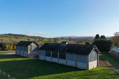 Added on 29/01/2026Barn
 Added on 24/08/2026Development Land
- Price
- Offers in Excess of£350,000
- Size
- 1.25 acres
Added on 29/01/2026Undeveloped LandLeasehold Added on 19/02/2026Commercial Land
- Price
- £350,000
- Size
- 0.5 acres
Methven Road, Grange-over-sands, LA11, Grange-over-Sands, Westmorland and Furness LA11 England
Added on 30/09/2026Development Land
- Price
- Offers in Excess of£275,000
Added on 29/01/2026Development Land Added on 05/10/2026Development Land
- Price
- £400,000
Added on 18/03/2026Development Land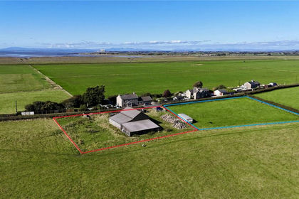
- Price
- Offers in Region of£325,000
- Size
- 0.57 acres
Sandside, Cockerham, Lancaster, Lancashire, Cockerham, Lancashire LA2 England
Added on 29/01/2026Building Plot
- Price
- £350,000
- Size
- 5.78 acres
Added on 20/07/2026Development Land