Canterbury, Kent
- Land size
- 3.86 acres
- Bedrooms
- 6
- Bathrooms
- 3
Key Features
- Charming 4 Bedroom House (1808 sq.ft.)
- Set in 3.86 acres (*TBV) Gardens and Paddocks
- Detached 2 Bedroom self contained Annex
- Immaculately Presented
- 4 Fenced Paddock varying sizes
- Option to add Riding Arena subject to PP
- Large Detached Building - Carport/Workshop/Office Space
- Ample parking area for cars/trailers
- Landscaped gardens with ornamental pond and terrace
- Sought after rural location - outskirts of Canterbury
Description
This delightful spacious family 4 bedroom house has the benefit of a detached 2 bedroom self-contained annexe with outbuildings and stables and is set in 3.86 acres(*TBV). Situated in the highly sought-after area of Broadoak, on the outskirts of the City of Canterbury with many of the rooms giving far reaching views across to Canterbury. To the rear, the garden has good views across the surrounding fields.
MAIN HOUSE
The property is immaculately presented and has been cleverly extended to provide excellent family living space, with an emphasis on bright and airy accommodation. Many features throughout include solid cherry wood flooring, under floor heating, double glazing and an air-conditioned garden room. On the ground floor and in addition to the garden room, there is an excellent double reception room with bay window to the front and attractive fireplace, and to the rear dining area. study,a cloakroom / shower room and modern kitchen with granite worktops, a range cooker with extractor above. On the first floor, there are four bedrooms and a modern family bathroom.
ANNEXE
The property also benefits from a detached two-bedroom self-contained annexe consisting of a sitting room / kitchen with French doors opening on to a paved area and access to the garden, ground floor bedroom and stairs to first floor bedroom with Velux windows.
Situation & Location - Broad Oak is found within 3 miles to the Cathedral city of Canterbury and is a lovely location with its own village hall, public house and convenience store.The City of Canterbury offers a wide variety of shops, bars, cafes and restaurants as well as numerous leisure, sporting and recreational facilities including Scotland Hills golf club, the Marlowe Theatre and Kent County cricket ground to name just a few.There are a number of highly regarded schools to be found in both the public and private sectors as well as the University of Kent and Christ Church University. Canterbury also has two mainline railway stations with Canterbury West station offering a high-speed service to London St. Pancras in under an hour.
There are country walks and riding out on bridleways which can accessed nearby.
Outside & Gardens - The property is reached off Shalloak Road by a driveway, with a right of access for the neighbouring properties, leading to a large parking and turning area at front of the property for cars and trailers. The large impressive rear garden has a well-maintained lawn with a variety of evergreens, shrubs, fruit trees and mature trees, with a large children’s play area, ornamental pond and large terraced seating area ideal for family summer dining. Additionally, there is a greenhouse and useful sheds within the gardens too.
Equestrian & Outbuilings - The land of around 3.86 acres (*TBV) is on opposite side of the driveway and can also approached separately by an additional access gate off Shalloak Road. There are 4 enclosed paddocks with 3 adjoining stables and a large outbuilding divided into workshop/office space and carport area. There is ample space to add a riding arena (subject to planning permission) The paddocks are screened by mature trees and overlooks the city centre.
Land - The acreage and or land shown or stated on any map and or screen print for the property is *TBV – (To Be Verified), which means that the land has not been formally measured and or verified by Equus and or its sellers/clients. A Title Plan from Land Registry will have been acquired, where available, showing the boundary and acreage. Otherwise, an online measuring tool will have been used to ‘check’ the acreage against the Land Registry Title where possible. Interested applicants/buyers are advised that if they have any doubts as to the plot size and wish to have verification of the titles and exact area of the entire plot(s), they will be required to make their own arrangements, at their own cost, by appointing the services of a Solicitor acting on their behalf and an accredited/qualified company who can measure the area for a compliant Land Registry Title Plan.
Material Imformation & Services - TENURE: Freehold
PROPERTY TYPE: Semi Detached - Detached Annexe
PROPERTY CONSTRUCTION: Brick built
NUMBER & TYPE OF ROOM/S: 6 bedrooms including annex (see floorplans)
PARKING: Multiple Areas
LOCAL AUTHORITY: CANTERBURY CITY COUNCIL
TITLE NUMBERS: K719147
TAX BAND : F
EPC RATING: E51 / C75 Certificate No - 3800-8443-0322-2005-3143
FLOOD RISK: Zone 1
WATER SUPPLY: Mains water
ELECTRICITY SUPPLY: Mains - House & Annexe
MAIN HOUSE HEATING: Oil central heating (installed outside around 2 years ago).Underfloor heating installed on 2 seperate zones.
ANNEXE HEATING : Calor gas
MAIN HOUSE DRAINAGE: Mains
ANNEXE DRAINAGE :(Septic Tank) which feeds into mains drain
BROADBAND: (see mobile coverage networks)
Helpful Websites - We recommend that you visit the local authority website pertaining to the property you are interested in buying for all the planning consents/restrictions/history and the following websites for more helpful information about the property and surrounding local area before proceeding in a purchase:
| | | | |
Viewing Arrangements - All Viewings are strictly by Appointment with Equus Country & Equestrian, South East/South West T: E: W:
DISCLAIMER: All prospective buyers view all properties for sale with Equus International Property Ltd at their own risk and neither the Agents, Joint Agents nor the Sellers take responsibility for any damage or injury however caused to themselves or personal belongings or property. By viewing a property with Equus you accept this disclaimer. If inspecting the outbuildings, equestrian facilities or any other building within the grounds you must wear appropriate clothing and footwear and children must be either left in the car or supervised at all times. Livestock should not be touched and all gates left shut or closed after use.
Map Location
Property details
- Tenure
- Freehold
- Council Tax Band
- F
- Date Posted
- 2026-01-28
Market Value Analysis
Compared with 1,861 Homes with Land listings in South East England (1+ acres).
Energy Performance Certificate
Energy Efficiency Rating
Based on UK Energy Performance Certificate standards (EU Directive 2002/91/EC)
Running costs are one side. Planning activity, flood history and ground risks for this location are in the full report.
Utilities & Restrictions
Utilities
- Electricity
- Mains
- Water
- Mains
- Heating
- Oil Heating
- Broadband
- Fibre (FTTC)
- Sewerage
- Mains
Rights & Restrictions
- Public Rights of Way
- Ask Agent
- Private Rights of Way
- Ask Agent
- Listed Property
- Ask Agent
- Restrictions
- Yes
Listed status, conservation areas and planning constraints for this location are in the full report.
Property Features
- Accessibility
- Ask Agent
- Parking
- Off-Street Parking
- Garden
- Garden
Beyond the particulars: planning activity, flood history, heritage and ground risks, checked for this exact spot.
Connectivity
Broadband
Fastest speed available at this postcode
16 Mbps
Standard (10-30 Mbps)
Suitable for
- Web & social
- Music streaming
- Standard video calls
Mobile signal
Outdoor predictions; indoor signal depends on building materials.
Ofcom Connected Nations postcode-level predictions. Speeds and signal are modelled, not measured, and vary between addresses and providers.
Signal is the easy part. Planning activity, flood history and protected designations here are in the full report.
Nearest Schools
Primary
- Sturry Church of England Primary School0.8 milesOfsted: Outstanding *
- Ages
- 4 to 11
- Pupils
- 414
- Type
- Academy converter
- Faith
- Church of England
- Parkside Community Foundation Primary School1.1 milesOfsted: Good
- Ages
- 4 to 11
- Pupils
- 161
- Type
- Foundation school
- St Stephen's Junior School1.5 milesNo Ofsted rating
- Ages
- 7 to 11
- Pupils
- 400
- Type
- Academy converter
- St Stephen's Infant School1.5 milesOfsted: Good
- Ages
- 5 to 7
- Pupils
- 263
- Type
- Academy converter
- St Johns Church of England Primary School1.8 milesOfsted: Good
- Ages
- 2 to 11
- Pupils
- 427
- Type
- Voluntary controlled school
- Faith
- Church of England
Secondary
- The Archbishop's School1.6 milesOfsted: Good
- Ages
- 11 to 18
- Pupils
- 770
- Type
- Foundation school
- Faith
- Church of England
- Orion Spires1.9 milesOfsted: Good
- Ages
- 11 to 16
- Pupils
- 620
- Type
- Academy sponsor led
- Barton Court Grammar School2 milesOfsted: Good
- Ages
- 11 to 18
- Pupils
- 995
- Type
- Academy converter
- Barton Manor School2.1 milesOfsted: Good *
- Ages
- 11 to 19
- Pupils
- 596
- Type
- Free schools
- The Canterbury Academy2.6 milesOfsted report card · Jan 2026
- Ages
- 11 to 19
- Pupils
- 1,984
- Type
- Academy converter
* Latest graded judgement covers quality of education only; no overall grade was issued under the 2024-25 inspection framework.
Distances are straight-line from the advertised location. Source: the national school registers (DfE, Welsh Government, Scottish Government) and Ofsted.
Schools are just the start: sold prices nearby, planning activity and any flood history are in the full report.
Amenities
Supermarket
GP surgery
Pharmacy
Hospital
Green space
Straight-line distances from the advertised location. Sources: NHS records, Geolytix supermarket locations, OS Open Greenspace and the national trails registers.
The area stacks up? Now check the location itself: planning nearby, protected designations and past flooding.
Getting Around
Nearest station
Nearest bus stop
Typical drive times
Straight-line distances from the advertised location; drive times are typical free-flow times over OpenStreetMap road data, so allow more at peak. Public transport locations from DfT NaPTAN.
Easy to reach matters. So do planning activity, flood history and ground risks: all in the full report.
Flood Risk
From Environment Agency flood map open data, checked around the advertised map pin and allowing for the listed acreage where known. This summary comes from LandSale, the advertising platform, not from the listing agent, and is not part of the agent's particulars. Risk can vary across a single holding, so verify anything critical through your own searches before committing.
Rivers and the sea
Surface water
The detail behind these bandings
The full report pinpoints where this location sits on the flood maps, and runs the deeper checks that usually only surface after an offer.
- Exact flood zones & annual chances (included in the full report)
- Any recorded past flooding (included in the full report)
- Planning activity nearby (included in the full report)
- Heritage & conservation (included in the full report)
- Protected nature designations (included in the full report)
- Ground risks (included in the full report)
- Sold prices nearby (included in the full report)
£14.99 · one-off purchase
By LandSale, the platform. Not provided by the listing agent. Ready in about a minute.
Important notice: Information, maps and tags on this page are drawn from the advertising agent's marketing materials or generated automatically. LandSale has not verified them. Relying on these details is at your own risk, always carry out independent checks before committing to a purchase.
LandSale full disclaimer
Marketing information only - not formal particulars. The details on this website are provided for general guidance and do not constitute an offer or contract. Neither LandSale nor the advertising estate/land agent accepts responsibility for any inaccuracy.
1. Source of information
- Listing content: Core description, asking price, tenure, measurements, photographs and planning history originate from the marketing materials of the advertising estate or land agent. LandSale does not author this content and cannot guarantee its accuracy.
- Automated tags & categorisation: Property type, land-use class, acreage bands and similar labels may be applied by machine-learning models. They are intended as a helpful guide only and may not reflect the property's legal status or permitted use.
- Third-party & enriched data layers: Maps, boundary outlines, planning designations, soil reports, broadband coverage and other environmental or location-based insights are licensed from external suppliers. Such data are supplied “as is", may be incomplete or out of date and are subject to change without notice.
2. Verification required
Prospective purchasers must verify critical matters, including but not limited to planning permission, title boundaries, public rights of way, environmental constraints, acreage, services, access and VAT status, through their own inspections, specialist surveys, legal advisers and the selling agent before relying on the information or entering into any contract.
3. No warranty or liability
LandSale gives no warranty, express or implied, as to the accuracy, completeness or fitness for any particular purpose of the information displayed. LandSale shall not be liable for any loss, damage, cost or expense arising directly or indirectly from any use of or reliance on such information, save where liability may not be excluded by law.
4. Updates & feedback
If you believe any detail on this listing is inaccurate, please let us know. We will investigate and, where appropriate, update the listing or notify the agent.
© LandSale | Version 1.3 - August 2026
Listing agent
Equus Country and Equestrian Property, South East
Head Office Lonsdale Gate Lonsdale Gardens Tunbridge Wells Kent TN1 1NU
Contact Equus Country and Equestrian Property, South East
Head Office Lonsdale Gate Lonsdale Gardens Tunbridge Wells Kent TN1 1NU
View agent profileSimilar properties for sale
- Price
- Guide Price£725,000
- Size
- 4 acres
Added on 14/08/2026Equestrian property
- Price
- £950,000
- Size
- 3 acres
The Old Vicarage, Boughton Hill, Dunkirk, Dunkirk, Kent ME13 England
Added on 29/01/2026Country Home
- Price
- £813,000
- Size
- 1 acres
Added on 24/03/2026House with Land
- Price
- £765,000
- Size
- 2.5 acres
Sole Street, Crundale, Canterbury, Kent, CT4, Crundale, Kent CT4 England
Added on 16/07/2026Equestrian property
- Price
- Guide Price£925,000
- Size
- 8 acres
Added on 21/05/2026Equestrian property
- Price
- £875,000
- Size
- 1.3 acres
Bilting Lane, Bilting, Ashford, Kent, TN25, Godmersham, Kent TN25 England
Added on 01/07/2026Country Home
- Price
- Guide Price£1,100,000
- Size
- 2.5 acres
Added on 08/08/2026House with Land
- Price
- Offers in Excess of£695,000
- Size
- 6 acres
Added on 15/03/2026House with Land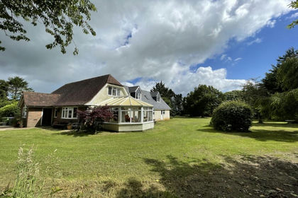
- Price
- Offers Over£895,000
- Size
- 2 acres
Longage Hill, Rhodes Minnis, Canterbury, Kent, CT4, Elham, Kent CT4 England
Added on 29/01/2026House with Land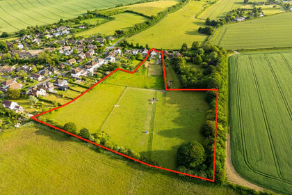
- Price
- Guide Price£870,000
- Size
- 5.42 acres
Added on 29/01/2026House with Land