New House Farm, Llandenny, Usk, Monmouthshire
- Land size
- 135 acres
- Bedrooms
- 4
- Bathrooms
- 2
Key Features
- Attractive and renowned livestock farm of about 135 acres.
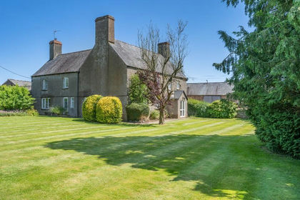
- Handsome period farmhouse with generous accommodation.
- No Chain.
- Three reception rooms, four large bedrooms and a large games room/barn.
- Impressive traditional large stone barns (planning permission for two residential dwellings) plus extensive parking.
- Range of modern agricultural buildings set around a separate large concrete yard.
- Suitable for livestock housing, storage of feed, machinery and workshops.
- Farmhouse EPC Rating E
Description
Attractive farm with traditional barns (Planning to convert into two residential properties) and numerous modern outbuildings. In all, extending to about 135 acres.
New House Farm is an attractive and renowned Monmouthshire livestock farm (home of the former Rosparry Herd) that has a strong residential appeal with a large handsome period house that is thought to date c.1600s with a large attractive walled garden. It is set on a traditional farmyard with two large stone barns that have extant Planning Permission for the conversion into two residential dwellings. Beyond the immediate traditional yard is the modern farmyard with an array of general purpose agricultural buildings. These are currently used for housing livestock, storage of feed, machinery and workshop purposes but would suit a multitude of uses. The farm extends to about 135 acres (stms - subject to measured survey) and includes quality pastureland for grazing and cropping.
Accommodation Ground Floor:
A welcoming front entrance porch leads into the reception hall with doors leading off to the principal reception rooms. On the left is the large reception room with a beamed ceiling, French door to the garden and an open fireplace providing a warm focal point. On the right is the dining room with an old character fireplace. This room leads into the kitchen area at the rear of the house that features modern fitted base and wall units, electric cooker, dishwasher and an extractor hood. Returning back into the hall there is useful pantry with slate worktop and oak shelving and then a second living room with beamed ceiling, wood burning stove and another French door to the garden. At the end of the hall is a door that leads to outside and the separate utility room with Belfast sink, plumbing for a washing machine, central heating boiler and useful shower room and cloakroom. Opposite is a large barn that is attached to the house and has been used as a fun games room in the past as well as a useful storage room/garage.
First Floor
Stairs rise up from the reception hall to the first floor accommodation that includes two large bedrooms facing the front of the house and two further large bedrooms, over-looking the gardens (all with built in wardrobes and two with convenient wash basins). A large family bathroom completes the floor.
Second Floor
Stairs continue to the second floor where here are three loft rooms that are currently not in use but have potential to be incorporated into the dwelling (stp - subject to planning).
Externally
The farmhouse has a pretty walled garden to the front and side with three large lawned areas, mature hedges, trees, bushes, shrubs, flower borders and numerous seating spots to enjoy. The garden is surrounded by high walls and hedges to provide extra privacy.
The Modern and Traditional Agricultural Buildings
The main entrance to the farm leads into the traditional farmyard with the handsome farm house on the left and two large impressive stone barns in front of you and on your right together with a smaller stone barn attached. As mentioned above, the two large barns have extant planning permission for conversion into two large residential dwellings. These would be ideal for an extended family or standalone dwellings. The barns are currently used for storage purposes. Full details of the Planning Permission in respect of the barns can be located under Planning Application Number: DM/2024/00328 (Monmouthshire Council).
Beyond these traditional stone barns is a large complex of modern clear span, general purpose agricultural buildings that are used for livestock housing, storage of feed, machinery and workshop purposes. This yard benefits from two separate access points from the main road. The
various sizes and layouts of the buildings provide a great deal of flexibility of use for a farming operation or for a multitude of other uses. These barns sit around a dedicated concrete yard that is suited for modern machinery and the movement and handling of livestock. At the rear of the buildings is a large manure store.
Adjacent to the property is a large block of about 89 acres (stms) of pasture land within a ring fence (yellow boundary) and accessed from the Llandenny and also Kingcoed Road. This land is divided into manageable enclosures for livestock and cropping and is accessible with modern machinery. Opposite the farmhouse is a pretty field on the edge of the village square that extends to about 1.2 acres (stms) (blue boundary).
A short distance away is a small parcel of grassland and hard-standing storage area that extends to about 2.6 acres (stms) (orange boundary) and is ideal for a pony paddock or amenity use. There is a sheep handling system with sheeted doors and concrete floor together with an adjoining field shelter.
Further land adjoins and is an excellent block of arable/grassland extending to about 29 acres (stms) (purple boundary) and divided into two level enclosures.
Joint Agent: Savills
For full details please see our brochure.
Map Location
Property details
- Tenure
- Freehold
- Council Tax Band
- Ask Agent
- Date Posted
- 2026-01-28
Market Value Analysis
Compared with 7 Livestock Farms listings in Wales (100+ acres).
Utilities & Restrictions
Utilities
- Electricity
- Ask Agent
- Water
- Ask Agent
- Heating
- Ask Agent
- Broadband
- Ask Agent
- Sewerage
- Ask Agent
Rights & Restrictions
- Public Rights of Way
- Ask Agent
- Private Rights of Way
- Ask Agent
- Listed Property
- Ask Agent
- Restrictions
- Ask Agent
Listed status, conservation areas and planning constraints for this location are in the full report.
Property Features
- Accessibility
- Ask Agent
- Parking
- Parking Available
- Garden
- Garden
Beyond the particulars: planning activity, flood history, heritage and ground risks, checked for this exact spot.
Connectivity
Broadband
Fastest speed available at this postcode
1.8 Gbps
Gigabit full fibre · available to 94% of premises
Suitable for
- 4K streaming on every screen
- Full-time home working
- Online gaming & big downloads
Fixed wireless access may also be an option here.
Mobile signal
Predicted 4G and 5G signal; indoor signal depends on building materials.
Ofcom Connected Nations postcode-level predictions. Speeds and signal are modelled, not measured, and vary between addresses and providers.
Signal is the easy part. Planning activity, flood history and protected designations here are in the full report.
Nearest Schools
Primary
- Raglan Primary1.8 miles
- Pupils
- 165
- Type
- Infants & Juniors
- Language
- English medium school / provision
- Usk Primary School3.5 miles
- Pupils
- 261
- Type
- Infants & Juniors
- Language
- English medium school / provision
- Trellech Junior & Infants4.8 miles
- Pupils
- 169
- Type
- Infants & Juniors
- Language
- English medium school / provision
- Goytre Fawr Primary6.3 miles
- Pupils
- 182
- Type
- Infants & Juniors
- Language
- English medium school / provision
- Llandogo Primary6.4 miles
- Pupils
- 64
- Type
- Infants & Juniors
- Language
- English medium school / provision
Secondary
- Monmouth Comprehensive School7.5 miles
- Pupils
- 1,696
- Type
- Secondary (ages 11-19)
- Language
- English medium school / provision
- Ysgol Gymraeg Gwynllyw8.8 miles
- Pupils
- 808
- Type
- Middle (ages 3-19)
- Language
- Welsh medium school / provision (including transitional)
- St. Albans R.C. High School9.1 miles
- Pupils
- 824
- Type
- Secondary (ages 11-16)
- Language
- English medium school / provision
- Chepstow Comprehensive School9.1 miles
- Pupils
- 860
- Type
- Secondary (ages 11-19)
- Language
- English medium school / provision
- West Monmouth School9.1 miles
- Pupils
- 1,149
- Type
- Secondary (ages 11-16)
- Language
- English medium school / provision
Distances are straight-line from the advertised location. Source: the national school registers (DfE, Welsh Government, Scottish Government) and Ofsted.
Schools are just the start: sold prices nearby, planning activity and any flood history are in the full report.
Amenities
Supermarket
GP surgery
Pharmacy
Straight-line distances from the advertised location. Sources: NHS records, Geolytix supermarket locations, OS Open Greenspace and the national trails registers.
The area stacks up? Now check the location itself: planning nearby, protected designations and past flooding.
Getting Around
Nearest station
Nearest bus stop
Typical drive times
Straight-line distances from the advertised location; drive times are typical free-flow times over OpenStreetMap road data, so allow more at peak. Public transport locations from DfT NaPTAN.
Easy to reach matters. So do planning activity, flood history and ground risks: all in the full report.
Flood Risk
Natural Resources Wales open data, checked around the advertised map pin for the listed acreage. Long-term risk counts flood defences; the planning map's flood zones do not. Provided by LandSale, not the listing agent, and not part of the agent's particulars. Risk varies across a holding, so verify before committing.
Rivers and the sea
Not at the pin: mapped about 420 metres away.
Planning map: Flood Zone 3, about 400 metres away.
Surface water
Not at the pin: mapped about 20 metres away.
These bandings are the summary. Where this location sits on the flood maps, plus planning activity, heritage and ground risks, is in the full report.
Important notice: Information, maps and tags on this page are drawn from the advertising agent's marketing materials or generated automatically. LandSale has not verified them. Relying on these details is at your own risk, always carry out independent checks before committing to a purchase.
LandSale full disclaimer
Marketing information only - not formal particulars. The details on this website are provided for general guidance and do not constitute an offer or contract. Neither LandSale nor the advertising estate/land agent accepts responsibility for any inaccuracy.
1. Source of information
- Listing content: Core description, asking price, tenure, measurements, photographs and planning history originate from the marketing materials of the advertising estate or land agent. LandSale does not author this content and cannot guarantee its accuracy.
- Automated tags & categorisation: Property type, land-use class, acreage bands and similar labels may be applied by machine-learning models. They are intended as a helpful guide only and may not reflect the property's legal status or permitted use.
- Third-party & enriched data layers: Maps, boundary outlines, planning designations, soil reports, broadband coverage and other environmental or location-based insights are licensed from external suppliers. Such data are supplied “as is", may be incomplete or out of date and are subject to change without notice.
2. Verification required
Prospective purchasers must verify critical matters, including but not limited to planning permission, title boundaries, public rights of way, environmental constraints, acreage, services, access and VAT status, through their own inspections, specialist surveys, legal advisers and the selling agent before relying on the information or entering into any contract.
3. No warranty or liability
LandSale gives no warranty, express or implied, as to the accuracy, completeness or fitness for any particular purpose of the information displayed. LandSale shall not be liable for any loss, damage, cost or expense arising directly or indirectly from any use of or reliance on such information, save where liability may not be excluded by law.
4. Updates & feedback
If you believe any detail on this listing is inaccurate, please let us know. We will investigate and, where appropriate, update the listing or notify the agent.
© LandSale | Version 1.3 - August 2026
Listing agent
Williams Associates Chartered Surveyors, Penpergwm
The Old School The Bryn Penpergwm Abergavenny Monmouthshire NP7 9AH
Contact Williams Associates Chartered Surveyors, Penpergwm
The Old School The Bryn Penpergwm Abergavenny Monmouthshire NP7 9AH
View agent profileSimilar properties for sale
- Price
- Guide Price£1,750,000
- Size
- 102 acres
New House Farm, Llandenny, Usk, Monmouthshire, Raglan, Monmouthshire NP15 Wales
Added on 29/01/2026Livestock Farm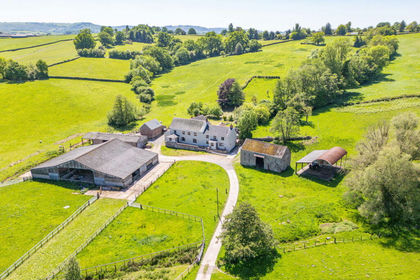
- Price
- Guide Price£2,150,000
- Size
- 116.17 acres
Great Lanolway, Llansoy, Usk, Monmouthshire, NP15, Llantrisant Fawr, Monmouthshire NP15 Wales
Added on 29/01/2026Farm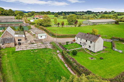
- Price
- Guide Price£1,600,000
- Size
- 100 acres
Added on 01/08/2026Farm
- Price
- Guide Price£2,115,000
- Size
- 276.09 acres
The Garn Fawr Lot 2, Llanhennock, Monmouthshire, NP18, Llangybi, Monmouthshire NP18 Wales
Added on 11/05/2026Farm
- Price
- £1,500,000
- Size
- 228 acres
Llanfoist, Abergavenny., Llanfoist Fawr, Monmouthshire NP7 Wales
Added on 11/05/2026Farmland
- Price
- £2,300,000
- Size
- 96.66 acres
Skenfrith, Abergavenny, Monmouthshire, NP7, Garway, Herefordshire, County of HR2 England
Added on 01/07/2026House with Land
- Price
- Offers in Region of£1,750,000
- Size
- 87.3 acres
Bacton, Hereford, St. Margarets, Herefordshire, County of HR2 England
Added on 19/04/2026Farm
- Price
- Guide Price£2,200,000
- Size
- 130 acres
Added on 25/07/2026Farm