Capel Madog, Aberystwyth
- Land size
- 14 acres
- Bedrooms
- 3
- Bathrooms
- 1
Description
Well located just a short distance inland from Aberystwyth a detached 3 Bedroomed farmhouse together with traditional outbuilding ripe for development and approximately 14 acres of land.
For Sale By Private Treaty -
Well located just a short distance inland from Aberystwyth a detached 3 Bedroomed farmhouse together with traditional outbuilding ripe for development and approximately 14 acres of land.
The hamlet of Capel Madog is within 6 miles of Aberystwyth in an area of unspoilt countryside. The nearby village of Capel Dewi provides access to the A4159 road for ease of access to Aberystwyth and beyond.
Aberystwyth is the largest town in the area with both local and National retailers as well as some tourist attractions. Major employers include the Welsh government offices, the University, National Library of Wales and Bronglais Hospital.
Gelli Fadog is approached over a farm track from the quiet council road. The majority of the land is down to productive pastures with an area of woodland alongside a tributary of the River Peithyll. The traditional outbuildings are suitable for conversion subject to obtaining the necessary consents. The farmhouse provides for commodious accommodation but requires some modernisation.
Tenure - Freehold
Viewing - Strictly by appointment with the sole selling agents. Aled Ellis & Co Ltd, 16 Terrace Road, Aberystwyth, Ceredigion, SY23 1NP or
Services - Mains electricity, private drainage and water.
Council Tax - Band E
Money Laundering - Successful parties will be required to provide sufficient up to date identification to verify your identity in compliance with the Money Laundering Regulations. For example: - Passport/ Photographic Driving licence and a current utility bill.
Gelli Fadog provides for all the following accommodation. All room dimensions are approximate. All images have been taken with a digital camera.
Ground Floor -
Front Entrance Door To -
Porch With Glazed Entrance Door To -
Living/Dining Room - 4.57m x 6.30m (15 x 20'8) - With 2 windows to fore, 2 radiators, stairs to first floor accommodation. Inglenook style fireplace with feature bread oven and slate hearth.
Rear Utility Porch - 4.80m x 2.13m (15'9 x 7) - With windows to rear and door to side, quarry tiled floor. Door to
Downstairs Wc - 2.31m x 2.06m (7'7 x 6'9) - Wash handbasin, radiator, free standing oil fired central heating.
Kitchen - 3.56m x 4.98m (11'8 x 16'4) - Comprising of base and eye level units, double drainer stainless steel sink unit. Oil fired Aga. Plumbing for automatic washing machine. Tiled floor, windows to fore and side. Door to
Utility Room - 2.46m x 3.51m (8'1 x 11'6) - With windows to side and rear, door to garden, tiled floor.
First Floor Accommodation -
Landing - Airing cupboard.
Bedroom 1 - 3.35m x 4.60m (11 x 15'1) - With window to fore, part exposed wooden beams, radiator.
Bedroom 2 - 2.67m x 3.99m (8'9 x 13'1) - With window to fore, part exposed wooden beams, radiator.
Bedroom 3 - 2.82m x 3.71m (9'3 x 12'2) - With window to fore, access to roof space, radiator.
Bathroom - 2.67m x 1.98m (8'9 x 6'6) - Comprising of Bath with mixer tap, WC, tiled walls, wash handbasin, radiator.
Externally - Ample vehicular hardstanding,
Traditional outbuilding (see photographs) comprising of former cart houses, granary cowshed, stables.
The land is divided into 4 enclosures and are in good heart. There is also an area of woodland included in the sale. See plan.
Directions - OS GRID REFERENCE: SN6560 82349
What 3 words//: tortoises.regress.locate
From Aberystwyth take the A44 Trunk Road inland to the Lovesgrove roundabout. Take the first exit on to the A4159 Capel Dewi (Bow Street) road. At Capel Dewi turn right at the crossroads and proceed for approximately a mile before turning right at the bottom of Cefn Llwyd. Proceed for a further mile passing several farms towards Capel Madog and the farm will signposted on your right.
Map Location
Property details
- Tenure
- Freehold
- Council Tax Band
- Ask Agent
- Date Posted
- 2026-01-28
Market Value Analysis
Compared with 168 Homes with Land listings in Wales (10+ acres).
Utilities & Restrictions
Utilities
- Electricity
- Ask Agent
- Water
- Ask Agent
- Heating
- Ask Agent
- Broadband
- Ask Agent
- Sewerage
- Ask Agent
Rights & Restrictions
- Public Rights of Way
- Ask Agent
- Private Rights of Way
- Ask Agent
- Listed Property
- Ask Agent
- Restrictions
- Ask Agent
Listed status, conservation areas and planning constraints for this location are in the full report.
Property Features
- Accessibility
- Ask Agent
- Parking
- Ask Agent
- Garden
- Garden
Beyond the particulars: planning activity, flood history, heritage and ground risks, checked for this exact spot.
Connectivity
Broadband
Fastest speed available at this postcode
1.8 Gbps
Standard (10-30 Mbps)
Suitable for
- 4K streaming on every screen
- Full-time home working
- Online gaming & big downloads
Mobile signal
Predicted 4G and 5G signal; indoor signal depends on building materials.
Ofcom Connected Nations postcode-level predictions. Speeds and signal are modelled, not measured, and vary between addresses and providers.
Signal is the easy part. Planning activity, flood history and protected designations here are in the full report.
Nearest Schools
Primary
- Ysgol Penllwyn1.2 miles
- Pupils
- 42
- Type
- Infants & Juniors
- Language
- Welsh medium school / provision (including transitional)
- Ysgol Penrhyncoch1.4 miles
- Pupils
- 115
- Type
- Infants & Juniors
- Language
- Welsh medium school / provision (including transitional)
- Ysgol Gymunedol Comins Coch2.6 miles
- Pupils
- 133
- Type
- Infants & Juniors
- Language
- Dual language school / provision (Welsh and English) (including transitional)
- Ysgol Gymunedol Rhydypennau2.7 miles
- Pupils
- 194
- Type
- Nursery, Infants & Juniors
- Language
- Welsh medium school / provision (including transitional)
- Ysgol Gymunedol Llanfihangel-Y-Creuddyn4 miles
- Pupils
- 16
- Type
- Infants & Juniors
- Language
- Welsh medium school / provision (including transitional)
Secondary
- Penglais School3.5 miles
- Pupils
- 1,120
- Type
- Secondary (ages 11-19)
- Language
- English medium school / provision
- Ysgol Gyfun Penweddig3.9 miles
- Pupils
- 587
- Type
- Secondary (ages 11-19)
- Language
- Welsh medium school / provision (including transitional)
- Ysgol Uwchradd Tywyn12 miles
- Pupils
- 376
- Type
- Secondary (ages 11-16)
- Language
- Dual language school / provision (Welsh and English) (including transitional)
- Ysgol Bro Hyddgen13 miles
- Pupils
- 441
- Type
- Middle (ages 4-19)
- Language
- Welsh medium school / provision (including transitional)
- Ysgol Henry Richard14 miles
- Pupils
- 387
- Type
- Middle (ages 3-16)
- Language
- Welsh medium school / provision (including transitional)
Distances are straight-line from the advertised location. Source: the national school registers (DfE, Welsh Government, Scottish Government) and Ofsted.
Schools are just the start: sold prices nearby, planning activity and any flood history are in the full report.
Amenities
Supermarket
GP surgery
Pharmacy
Straight-line distances from the advertised location. Sources: NHS records, Geolytix supermarket locations, OS Open Greenspace and the national trails registers.
The area stacks up? Now check the location itself: planning nearby, protected designations and past flooding.
Getting Around
Nearest station
Nearest bus stop
Typical drive times
Straight-line distances from the advertised location; drive times are typical free-flow times over OpenStreetMap road data, so allow more at peak. Public transport locations from DfT NaPTAN.
Easy to reach matters. So do planning activity, flood history and ground risks: all in the full report.
Flood Risk
Natural Resources Wales open data, checked around the advertised map pin for the listed acreage. Long-term risk counts flood defences; the planning map's flood zones do not. Provided by LandSale, not the listing agent, and not part of the agent's particulars. Risk varies across a holding, so verify before committing.
Rivers and the sea
Planning map: Flood Zone 1.
Surface water
Not at the pin: mapped about 30 metres away.
These bandings are the summary. Where this location sits on the flood maps, plus planning activity, heritage and ground risks, is in the full report.
Important notice: Information, maps and tags on this page are drawn from the advertising agent's marketing materials or generated automatically. LandSale has not verified them. Relying on these details is at your own risk, always carry out independent checks before committing to a purchase.
LandSale full disclaimer
Marketing information only - not formal particulars. The details on this website are provided for general guidance and do not constitute an offer or contract. Neither LandSale nor the advertising estate/land agent accepts responsibility for any inaccuracy.
1. Source of information
- Listing content: Core description, asking price, tenure, measurements, photographs and planning history originate from the marketing materials of the advertising estate or land agent. LandSale does not author this content and cannot guarantee its accuracy.
- Automated tags & categorisation: Property type, land-use class, acreage bands and similar labels may be applied by machine-learning models. They are intended as a helpful guide only and may not reflect the property's legal status or permitted use.
- Third-party & enriched data layers: Maps, boundary outlines, planning designations, soil reports, broadband coverage and other environmental or location-based insights are licensed from external suppliers. Such data are supplied “as is", may be incomplete or out of date and are subject to change without notice.
2. Verification required
Prospective purchasers must verify critical matters, including but not limited to planning permission, title boundaries, public rights of way, environmental constraints, acreage, services, access and VAT status, through their own inspections, specialist surveys, legal advisers and the selling agent before relying on the information or entering into any contract.
3. No warranty or liability
LandSale gives no warranty, express or implied, as to the accuracy, completeness or fitness for any particular purpose of the information displayed. LandSale shall not be liable for any loss, damage, cost or expense arising directly or indirectly from any use of or reliance on such information, save where liability may not be excluded by law.
4. Updates & feedback
If you believe any detail on this listing is inaccurate, please let us know. We will investigate and, where appropriate, update the listing or notify the agent.
© LandSale | Version 1.3 - August 2026
Listing agent
Aled Ellis & Co Ltd, Aberystwyth
16 Terrace Road, Aberystwyth, SY23 1NP
View agent profileSimilar properties for sale
- Price
- Guide Price£585,000
- Size
- 29 acres
Added on 08/08/2026Smallholding
- Price
- Guide Price£595,000
- Size
- 8 acres
Added on 29/01/2026Smallholding
- Price
- Guide Price£535,000
- Size
- 55.1 acres
Devils Bridge, Aberystwyth, Pontarfynach, Ceredigion SY23 Wales
Added on 29/01/2026Farm
- Price
- Guide Price£625,000
- Size
- 8.9 acres
Added on 29/01/2026House with Land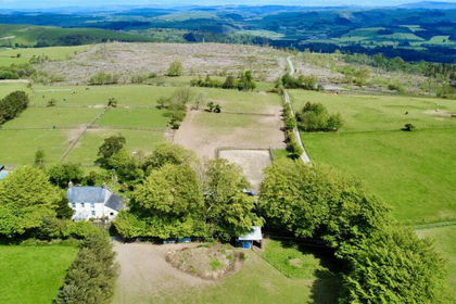
- Price
- £640,000
- Size
- 18 acres
Added on 05/06/2026Smallholding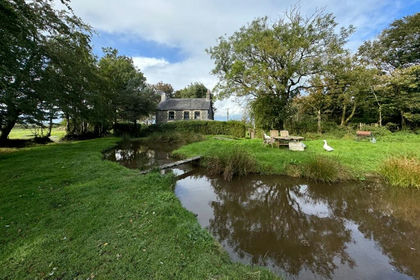
- Price
- £595,000
- Size
- 34 acres
Trefenter, Aberystwyth, SY23, Llangwyryfon, Ceredigion SY23 Wales
Added on 29/01/2026Smallholding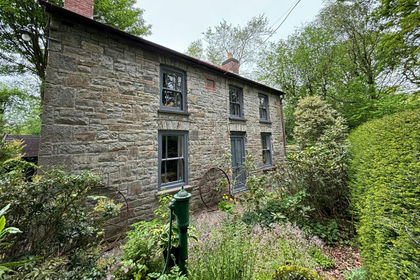
- Price
- £625,000
- Size
- 20 acres
Llangeitho, Tregaron, SY25, Llangeitho, Ceredigion SY25 Wales
Added on 29/01/2026Smallholding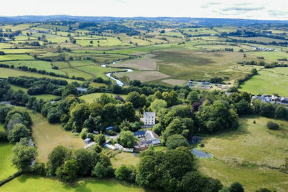
- Price
- £695,000
- Size
- 17 acres
Added on 29/01/2026Country Home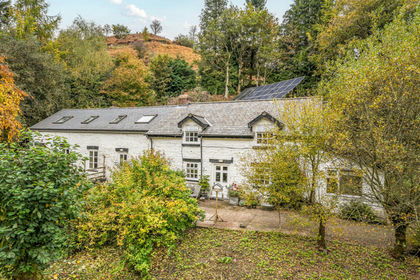
- Price
- Guide Price£650,000
- Size
- 13.57 acres
Van, Llanidloes, Powys, SY18, Llanidloes Without, Powys SY18 Wales
Added on 29/01/2026Cottage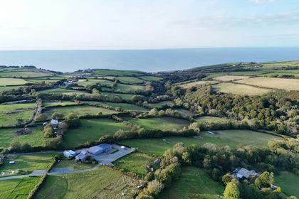
- Price
- £665,000
- Size
- 14.2 acres
Upper Aberarth, Aberaeron, SA46, Dyffryn Arth, Ceredigion SA46 Wales
Added on 29/01/2026Smallholding