Netton, NOSS MAYO, South Devon
- Bedrooms
- 3
- Bathrooms
- 2
Key Features
- Barn Conversion
- Peaceful coastal retreat
- Secluded gardens and terraces
- Annex with kitchenette/living room, shower room and bedroom
- Private parking for two vehicles
- Shared heated indoor pool (April to early November)
- Close to South West Coastal Path
- Character features throughout
- Conservatory
- No chain
Description
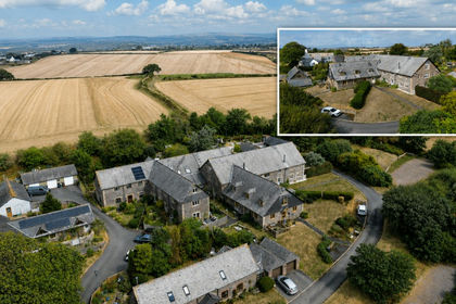
Withie is a charming barn conversion, quietly located in a secluded garden with off road parking for two vehicles. This well maintained home offers beautifully presented accommodation throughout with a self-contained, 1 bedroom apartment which has been used as a productive letting unit by the current owner. The main house provides a bright, sunny kitchen fitted with base and wall units, a spacious living room with feature LPG log effect stove and double doors through to a conservatory that opens directly onto a sheltered patio.
Upstairs there are two bedrooms, with exposed roof trusses and a family bathroom.
Outside, the garden has been meticulously planned with brick paviour pathways bordered by mature shrubs and trees providing areas of dappled shade. A raised patio is the perfect spot to enjoy the evening sun, and leads to a useful storage area and concealed gas cylinder tank. The cottage also benefits from off road parking for 2 vehicles.
Withie benefits from sharing a communal indoor heated swimming pool which is available from April to October by separate arrangement. (Subject to optional Service Charge)
SITUATION AND DESCRIPTION
Netton is idyllically situated close to the South Hams coastline, surrounded by glorious countryside and the Estuary of the River Yealm with its excellent sailing waters. It is only a short walk to the South Devon coastal path and the 'carriage drive' along the cliffs, formerly part of The Revelstoke Estate. Netton today consists of a farmhouse and separate, privately owned barn conversions with two adjacent farm bungalows. Each owner becomes part of the management company which maintains facilities and drainage etc.
The twin villages of Newton Ferrers and Noss Mayo enjoy a delightful riverside setting on the wooded slopes of the estuary of the River Yealm. This sheltered, deep water harbour is much favoured by yachtsmen and lies within a truly beautiful valley in the unspoilt South Hams countryside, an Area of Outstanding Natural Beauty.
The villages share a number of facilities including a post office, pharmacy, Co-operative store, three good public houses, two churches, yacht club with bistro and good Primary School. Bus services run to Plymouth city centre which is within easy commuting distance. The main route from Plymouth to Exeter (A38/M5 Devon Expressway) is only a few miles away. Intercity trains run daily from Plymouth to Paddington. Plymouth Continental Ferryport is also easily accessible. All combine to give superb access to the rest of the country, combined with living in one of the most beautiful riverside locations on the south coast.
Plymouth itself is an historic and vibrant waterside City, well provided with colleges, grammar and public schools, modern university, the Peninsula Medical School, Theatre Royal and cinemas, large department store, cafes, bistros and restaurants. The leisure facilities are outstanding with superb watersports in and around Plymouth Sound.
FURTHER INFOMATION
As part of our transparency policy, we request our sellers fill out a Property Information Questionnaire. This information can be provided to you. However, we recommend that you verify any information given during the conveyance process.
Council Tax: Band C
Tenure: Freehold. No chain.
Management Company: Covers the cost of maintaining and insuring the sewerage plant. Current management charges are £79.63 quarterly, £318.52 per annum. Withie also benefits from sharing a communal indoor heated swimming pool which is available from April - October by separate arrangement. (Subject to optional service charge).
Standard construction
Electric: mains. Water: mains - metered. Heating: LPG Boiler and LPG Fire. Sewerage: Private. Broadband: FTTP subject to connection. Mobile signal:
Parking: Driveway
Local Authority: South Hams District Council, Follaton House, Plymouth Road, Totnes TQ9 5NE. Tel:
Viewing: Strictly by appointment with Luscombe Maye
Directions: From the A379, Plymouth to Kingsbridge Road, take the B3186 signposted Newton Ferrers. Enter the village of Newton Ferrers and at The Green take the left hand fork signposted Noss Mayo/Membland. Continue down Bridgend Hill, around the hairpin bend at the head of the Creek and follow Stoke Road all the way up through Noss Mayo. About ¼ mile out of the village, take the right hand turning signposted Netton. At Netton, turn left into the drive between Slade Barn and Netton Farmhouse and continue around to Withie, which is just on the left hand side.
Lettings: Luscombe Maye also offers an Award Winning Lettings service. Please contact Andrew or Alex on or to discuss our range of bespoke services.
Map Location
Property details
- Tenure
- Freehold
- Council Tax Band
- C
- Date Posted
- 2026-01-29
Energy Performance Certificate
Energy Efficiency Rating
Based on UK Energy Performance Certificate standards (EU Directive 2002/91/EC)
Running costs are one side. Planning activity, flood history and ground risks for this location are in the full report.
Utilities & Restrictions
Utilities
- Electricity
- Mains
- Water
- Mains
- Heating
- Gas Heating, Double Glazing
- Broadband
- Full Fibre (FTTP)
- Sewerage
- Septic Tank / Private
Rights & Restrictions
- Public Rights of Way
- Ask Agent
- Private Rights of Way
- Ask Agent
- Listed Property
- Ask Agent
- Restrictions
- Ask Agent
Listed status, conservation areas and planning constraints for this location are in the full report.
Property Features
- Accessibility
- Ask Agent
- Parking
- Off-Street Parking
- Garden
- Private Garden
Beyond the particulars: planning activity, flood history, heritage and ground risks, checked for this exact spot.
Connectivity
Broadband
Fastest speed available at this postcode
11 Mbps
Standard (10-30 Mbps)
Suitable for
- Web & social
- Music streaming
- Standard video calls
Fixed wireless access may also be an option here.
Mobile signal
Outdoor predictions; indoor signal depends on building materials.
Ofcom Connected Nations postcode-level predictions. Speeds and signal are modelled, not measured, and vary between addresses and providers.
Signal is the easy part. Planning activity, flood history and protected designations here are in the full report.
Nearest Schools
Primary
- Newton Ferrers Church of England Primary School1.2 milesOfsted: Good
- Ages
- 2 to 11
- Pupils
- 125
- Type
- Academy converter
- Faith
- Church of England
- Wembury Primary School2.3 milesOfsted report card · Mar 2026
- Ages
- 4 to 11
- Pupils
- 194
- Type
- Academy converter
- St Mary's Church of England Primary School3.5 milesOfsted: Good *
- Ages
- 4 to 11
- Pupils
- 100
- Type
- Voluntary aided school
- Faith
- Church of England
- Yealmpton Primary School3.6 milesOfsted: Good
- Ages
- 4 to 11
- Pupils
- 173
- Type
- Academy converter
- Elburton Primary School4.3 milesOfsted: Outstanding *
- Ages
- 2 to 11
- Pupils
- 470
- Type
- Academy converter
Secondary
- Coombe Dean School4.1 milesOfsted report card · Mar 2026
- Ages
- 11 to 18
- Pupils
- 1,000
- Type
- Academy converter
- Plymstock School4.8 milesOfsted: Good
- Ages
- 11 to 18
- Pupils
- 1,515
- Type
- Academy converter
- Plympton Academy6.1 milesOfsted: Requires improvement
- Ages
- 11 to 18
- Pupils
- 984
- Type
- Academy converter
- Hele's School6.5 milesNo Ofsted rating
- Ages
- 11 to 18
- Pupils
- 1,378
- Type
- Academy converter
- Lipson Co-operative Academy6.6 milesOfsted report card · Apr 2026
- Ages
- 11 to 18
- Pupils
- 1,131
- Type
- Academy converter
* Latest graded judgement covers quality of education only; no overall grade was issued under the 2024-25 inspection framework.
Distances are straight-line from the advertised location. Source: the national school registers (DfE, Welsh Government, Scottish Government) and Ofsted.
Schools are just the start: sold prices nearby, planning activity and any flood history are in the full report.
Amenities
Supermarket
GP surgery
Pharmacy
Hospital
Green space
Walking trail
Straight-line distances from the advertised location. Sources: NHS records, Geolytix supermarket locations, OS Open Greenspace and the national trails registers.
The area stacks up? Now check the location itself: planning nearby, protected designations and past flooding.
Getting Around
Nearest station
Nearest bus stop
Typical drive times
Straight-line distances from the advertised location; drive times are typical free-flow times over OpenStreetMap road data, so allow more at peak. Public transport locations from DfT NaPTAN.
Easy to reach matters. So do planning activity, flood history and ground risks: all in the full report.
Flood Risk
From Environment Agency flood map open data, checked around the advertised map pin and allowing for the listed acreage where known. This summary comes from LandSale, the advertising platform, not from the listing agent, and is not part of the agent's particulars. Risk can vary across a single holding, so verify anything critical through your own searches before committing.
Rivers and the sea
Surface water
The detail behind these bandings
The full report pinpoints where this location sits on the flood maps, and runs the deeper checks that usually only surface after an offer.
- Exact flood zones & annual chances (included in the full report)
- Any recorded past flooding (included in the full report)
- Planning activity nearby (included in the full report)
- Heritage & conservation (included in the full report)
- Protected nature designations (included in the full report)
- Ground risks (included in the full report)
- Sold prices nearby (included in the full report)
£14.99 · one-off purchase
By LandSale, the platform. Not provided by the listing agent. Ready in about a minute.
Important notice: Information, maps and tags on this page are drawn from the advertising agent's marketing materials or generated automatically. LandSale has not verified them. Relying on these details is at your own risk, always carry out independent checks before committing to a purchase.
LandSale full disclaimer
Marketing information only - not formal particulars. The details on this website are provided for general guidance and do not constitute an offer or contract. Neither LandSale nor the advertising estate/land agent accepts responsibility for any inaccuracy.
1. Source of information
- Listing content: Core description, asking price, tenure, measurements, photographs and planning history originate from the marketing materials of the advertising estate or land agent. LandSale does not author this content and cannot guarantee its accuracy.
- Automated tags & categorisation: Property type, land-use class, acreage bands and similar labels may be applied by machine-learning models. They are intended as a helpful guide only and may not reflect the property's legal status or permitted use.
- Third-party & enriched data layers: Maps, boundary outlines, planning designations, soil reports, broadband coverage and other environmental or location-based insights are licensed from external suppliers. Such data are supplied “as is", may be incomplete or out of date and are subject to change without notice.
2. Verification required
Prospective purchasers must verify critical matters, including but not limited to planning permission, title boundaries, public rights of way, environmental constraints, acreage, services, access and VAT status, through their own inspections, specialist surveys, legal advisers and the selling agent before relying on the information or entering into any contract.
3. No warranty or liability
LandSale gives no warranty, express or implied, as to the accuracy, completeness or fitness for any particular purpose of the information displayed. LandSale shall not be liable for any loss, damage, cost or expense arising directly or indirectly from any use of or reliance on such information, save where liability may not be excluded by law.
4. Updates & feedback
If you believe any detail on this listing is inaccurate, please let us know. We will investigate and, where appropriate, update the listing or notify the agent.
© LandSale | Version 1.3 - August 2026
Listing agent
Luscombe Maye, Newton Ferrers
Newton Hill, Newton Ferrers, PL8 1AA
Similar properties for sale
 Added on 01/09/2026Barn Conversion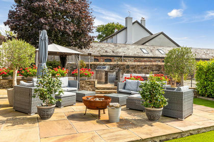
- Price
- Guide Price£599,950
Hareston Farm Barns, Yealmpton, Devon, Brixton, Devon PL8 England
Added on 11/07/2026Barn Conversion
- Price
- Guide Price£675,000
Swainstone Manor, Ivybridge, Devon, PL21, Yealmpton, Devon PL7 England
Added on 07/09/2026Barn Conversion
- Price
- £550,000
- Size
- 0.5 acres
Added on 29/04/2026Barn Conversion
- Price
- Guide Price£625,000
- Size
- 5.5 acres
Added on 13/05/2026Barn Conversion
- Price
- Guide Price£550,000
Added on 27/03/2026Barn Conversion
- Price
- Guide Price£525,000
- Size
- 6 acres
Added on 17/03/2026Smallholding
- Price
- Guide Price£695,000
- Size
- 0.75 acres
Wakeham Barns, Aveton Gifford, TQ7, Aveton Gifford, Devon TQ7 England
Added on 10/08/2026Barn Conversion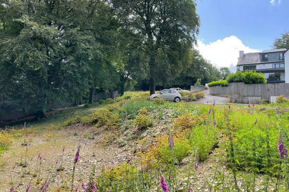
- Price
- Offers in Excess of£550,000
- Size
- 2 acres
Added on 29/01/2026Building Plot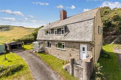
- Price
- Guide Price£575,000
- Size
- 1 acres
Added on 29/01/2026Cottage