Llanafan, Aberystwyth, SY23
- Land size
- 17.7 acres
- Bedrooms
- 4
- Bathrooms
- 2
Key Features
- Ystwyth Valley Near Aberystwyth
- 17.7 Acre Smallholding
- Fully Refurbished 4 bed farmhouse
- Range of traditional outbuildings
- Ideal for conversion
- Additional 48 acres available by sep negotiation
- Private driveway access
- AN OPPORTUNITY NOT TO BE MISSED
Description
**17.7 Acre Smallholding**Fully refurbished 4 bed farmhouse**Attractive range of traditional stone and slate outbuildings, ripe for conversion**Outstanding views over the Ystwyth valley**Highly productive grassland**Highly Productive grassland split into 3 enclosures**Additional 48 acres available by separate negotiation**Private driveway access**A historic local holding**Planning Permission for alterations & extensions**A Wonderful and traditional property set in the heart of the Ystwyth Valley, rarely available in such excellent order**AN OPPORTUNITY NOT TO BE MISSED ! **
The property is situated within the popular rural village of Llanafan, the village boasts an active community hall which relies mainly on nearby Llanilar for its day to day needs including primary school, village shop and post office. The nearby Mid Wales strategic town of Aberystwyth is some 15 minutes drive from the property offering a good level of local services and amenities including regional hospital, university, national library, Welsh Government and council offices, retail parks, supermarkets, local cafes, bars, restaurants, leisure centres and access to the famous promenade.
We are advised the property benefits from mains water, electricity, new private drainage system, new electric heating system.
GENERAL
An exceptional rural property having recently been subject to refurbishment although retaining a wealth of original character features.
The property provides 4 bedroom accommodation to the main house with excellent supporting living accommodation. At this stage there is still an opportunity for a new owner to put their own stamp on the property.
The works to the main house include -
New mains water connection.
Electrical re-wiring of all areas apart from the former kitchen area.
New hot and cold plumbing and waste connections.
New kitchen
New shower facilities to ground floor.
Redecorated throughout.
New facias and soffits.
Repointed chimneys finished in lime render with concrete capping and clay chimney pots.
New white pvc sliding sash windows to main house front elevation.
New upvc casement windows to all other areas.
New foul drainage and treatment works.
New concrete paths to rear.
PLANNING PERMISSION FOR HOUSE ALTERATIONS & EXTENSIONS
We are advised that planning permission is in place for "Proposed alterations and extension to the existing farmhouse inclusive of a change of use of part of the adjoining outbuilding into residential use". Approved drawings and copies of the planning permission are available for inspection from the selling agents, Ceredigion County council planning reference A211090 granted 23rd March 2022. Condition 8 of the planning permission has been discharged in order to allow development to take place (ref A230814 granted 18th January 2024). Approved elevations and floor plans are included within these details.
Reception Hallway
Slate floor, stairs to first floor. Door leading to -
Living Room
16' 2" x 8' 2" (4.93m x 2.49m) Sunhouse night storage heater. Tiled fireplace set within original inglenook fire place, large slate flagstone floors, window to fore. Recess with shelving.
Modern Kitchen
7' 9" x 16' 9" (2.36m x 5.11m) Base units with integrated Lamona electric cooker and 4 ring Lamona hob with stainless steel extractor fan over. 1.5 bowl single drainer stainless steel sink unit with mixer tap. Sunhouse night storage heater. Door and window to rear. Brick wall feature and splashbacks.
Utility Area/Shower Room
8' 0" x 10' 1" (2.44m x 3.07m) Plumbing for washing machine. WC, wash basin, large shower cubicle with Mira shower. Shaver point and light. Night storage heater. Obscured window to rear.
Inner Hallway
With door to fore.
Former Kitchen & Secondary Lounge
18' 3" x 14' 9" (5.56m x 4.50m) Former Kitchen area ideal as additional living space or potential for side annexe with access to loft over, this area has planning permission to be amended also as per the reference to approved drawings.
Secondary Lounge
18' 3" x 14' 9" (5.56m x 4.50m) Retaining original features of Inglenook fireplace with bread oven and exposed beams. Oil fired Rayburn as seen.
Stairs to -
Loft
A framed beams, restricted headroom. Windows to fore and rear.
Bedroom 1
8' 3" x 16' 2" (2.51m x 4.93m) Double bedroom, Electric heater, exposed wooden floor. Recess cupboard and recess with shelving. Window to fore.
Bedroom 2/Office
7' 3" x 5' 7" (2.21m x 1.70m) Electric heater, exposed wooden floor and window to fore.
Bedroom 3
8' 2" x 16' 5" (2.49m x 5.00m) Electric heater, exposed wooden floor, recess cupboard and window to fore & access to loft over kitchen.
Bedroom 4
5' 6" x 8' 3" (1.68m x 2.51m) L Shaped. Sloping headroom, exposed wooden floor, electric heater and window to rear.
Bathroom
Bath with mixer tap. Low level flush WC and washbasin. Exposed wooden floor, heated towel rail. Airing cupboard. Window to rear.
To the front
To the front of the main house is a raised footpath leading down to a concrete forecourt area from the driveway.
To the rear
To the rear of the house is a new concrete footpath and path leading to one of the steel outbuildings.
Traditional Stone and Slate Range Outbuildings
Situated to the side of the main dwelling.
Finished in lime wash render under a traditional Welsh slate roof and part box profile clad in places with part first floor loft over. Views from the yard over the front fields and the Ystwyth Valley and Llanafan Village. Providing -
Store and Feed Room
13' 6" x 16' 0" (4.11m x 4.88m) last used for animal housing with window to front, side stable door, also providing access to -
Stable Block
12' 5" x 16' 0" (3.78m x 4.88m) with 2 stables, window to front.
Former Cow Shed
15' 3" x 16' 0" (4.65m x 4.88m) with stable door and window to front. Feed trough to rear.
Animal Housing Unit
16' 0" x 34' 0" (4.88m x 10.36m) with exposed A frames to ceiling, 2 stables/cubicles and feed troughs to rear, slate flag stone flooring.
L shaped Corner Unit
25' 0" x 54' 0" (7.62m x 16.46m) currently of stone construction, lime washed finished under a box profile roof with exposed A frames to ceiling, last used for animal housing with excellent conversion potential. Having water and electricity connection.
Former Dairy
7' 9" x 10' 2" (2.36m x 3.10m) with window to front, concrete base, water connection.
Stone Lean To
16' 0" x 19' 0" (4.88m x 5.79m) of stone construction with slated roof, open ended to front with concrete base.
Side Muck Store
With access to adjoining fields.
Modern steel framed building
115' 0" x 50' 0" (35.05m x 15.24m) of steel framed construction being zinc clad with zinc roof over.
Part Block Cubicles
Currently used as stables, open ended to one end, steel doors to the other, side open lean to with access to adjoining fields, water and electric connection.
Log Store
19' 0" x 25' 0" (5.79m x 7.62m) of timber frame construction being zinc clad and open ended to front providing excellent dry storage area.
Sheep Dip and Handling Area
with concrete base and breeze block sheep runs.
THE LAND
The land is split into three large enclosures with a productive 7.6 acre parcel to the front of the property accessed from the adjoining private lane that forms part of the property.
To the eastern boundaries of the property area two sloping enclosures measuring 2.22 Acres and 6.05 acres respectively providing excellent grazing land to the rear of the outbuildings. These benefit from track access.
ADDITIONAL LAND
Please note - There is also an option to purchase an additional 48 Acres of grazing and cropping land to the north of the holding and this is currently split into 6 separate enclosures and available to negotiation.
Map Location
Property details
- Tenure
- Freehold
- Council Tax Band
- Ask Agent
- Date Posted
- 2026-01-29
Market Value Analysis
Compared with 203 Farms & Smallholdings listings in Wales (10+ acres).
Energy Performance Certificate
Energy Efficiency Rating
Based on UK Energy Performance Certificate standards (EU Directive 2002/91/EC)
Running costs are one side. Planning activity, flood history and ground risks for this location are in the full report.
Utilities & Restrictions
Utilities
- Electricity
- Ask Agent
- Water
- Ask Agent
- Heating
- Ask Agent
- Broadband
- Ask Agent
- Sewerage
- Ask Agent
Rights & Restrictions
- Public Rights of Way
- Ask Agent
- Private Rights of Way
- Ask Agent
- Listed Property
- Ask Agent
- Restrictions
- Ask Agent
Listed status, conservation areas and planning constraints for this location are in the full report.
Property Features
- Accessibility
- Ask Agent
- Parking
- Parking Available
- Garden
- Garden
Beyond the particulars: planning activity, flood history, heritage and ground risks, checked for this exact spot.
Connectivity
Broadband
Fastest speed available at this postcode
1.8 Gbps
Gigabit full fibre
Suitable for
- 4K streaming on every screen
- Full-time home working
- Online gaming & big downloads
Fixed wireless access may also be an option here.
Mobile signal
Outdoor predictions; indoor signal depends on building materials.
Ofcom Connected Nations postcode-level predictions. Speeds and signal are modelled, not measured, and vary between addresses and providers.
Signal is the easy part. Planning activity, flood history and protected designations here are in the full report.
Nearest Schools
Primary
- Ysgol Gymunedol Llanfihangel-Y-Creuddyn2.6 miles
- Pupils
- 16
- Type
- Infants & Juniors
- Language
- Welsh medium school / provision (including transitional)
- Ysgol Gymunedol Mynach3.8 miles
- Pupils
- 45
- Type
- Infants & Juniors
- Language
- Welsh medium school / provision (including transitional)
- Ysgol Gymunedol Pontrhydfendigaid4.3 miles
- Pupils
- 53
- Type
- Infants & Juniors
- Language
- Welsh medium school / provision (including transitional)
- Ysgol Llanilar4.3 miles
- Pupils
- 106
- Type
- Infants & Juniors
- Language
- Welsh medium school / provision (including transitional)
- Ysgol Penllwyn5.4 miles
- Pupils
- 42
- Type
- Infants & Juniors
- Language
- Welsh medium school / provision (including transitional)
Secondary
- Ysgol Gyfun Penweddig7.9 miles
- Pupils
- 587
- Type
- Secondary (ages 11-19)
- Language
- Welsh medium school / provision (including transitional)
- Penglais School7.9 miles
- Pupils
- 1,120
- Type
- Secondary (ages 11-19)
- Language
- English medium school / provision
- Ysgol Henry Richard8.1 miles
- Pupils
- 387
- Type
- Middle (ages 3-16)
- Language
- Welsh medium school / provision (including transitional)
- Gyfun Aberaeron Comprehensive15 miles
- Pupils
- 573
- Type
- Secondary (ages 11-19)
- Language
- Welsh medium school / provision (including transitional)
- Ysgol Bro Pedr17 miles
- Pupils
- 967
- Type
- Middle (ages 3-19)
- Language
- Dual language school / provision (Welsh and English) (including transitional)
Distances are straight-line from the advertised location. Source: the national school registers (DfE, Welsh Government, Scottish Government) and Ofsted.
Schools are just the start: sold prices nearby, planning activity and any flood history are in the full report.
Amenities
Supermarket
GP surgery
Pharmacy
Green space
Straight-line distances from the advertised location. Sources: NHS records, Geolytix supermarket locations, OS Open Greenspace and the national trails registers.
The area stacks up? Now check the location itself: planning nearby, protected designations and past flooding.
Getting Around
Nearest station
Nearest bus stop
Typical drive times
Straight-line distances from the advertised location; drive times are typical free-flow times over OpenStreetMap road data, so allow more at peak. Public transport locations from DfT NaPTAN.
Easy to reach matters. So do planning activity, flood history and ground risks: all in the full report.
Flood Risk
From Natural Resources Wales flood map open data, checked around the advertised map pin and allowing for the listed acreage where known. This summary comes from LandSale, the advertising platform, not from the listing agent, and is not part of the agent's particulars. Risk can vary across a single holding, so verify anything critical through your own searches before committing.
Rivers and the sea
Surface water
Mapped within the area searched, not at the advertised map pin itself.
The detail behind these bandings
The full report pinpoints where this location sits on the flood maps, and runs the deeper checks that usually only surface after an offer.
- Exact flood zones & annual chances (included in the full report)
- Any recorded past flooding (included in the full report)
- Planning activity nearby (included in the full report)
- Heritage & conservation (included in the full report)
- Protected nature designations (included in the full report)
- Ground risks (included in the full report)
- Sold prices nearby (included in the full report)
£14.99 · one-off purchase
By LandSale, the platform. Not provided by the listing agent. Ready in about a minute.
Important notice: Information, maps and tags on this page are drawn from the advertising agent's marketing materials or generated automatically. LandSale has not verified them. Relying on these details is at your own risk, always carry out independent checks before committing to a purchase.
LandSale full disclaimer
Marketing information only - not formal particulars. The details on this website are provided for general guidance and do not constitute an offer or contract. Neither LandSale nor the advertising estate/land agent accepts responsibility for any inaccuracy.
1. Source of information
- Listing content: Core description, asking price, tenure, measurements, photographs and planning history originate from the marketing materials of the advertising estate or land agent. LandSale does not author this content and cannot guarantee its accuracy.
- Automated tags & categorisation: Property type, land-use class, acreage bands and similar labels may be applied by machine-learning models. They are intended as a helpful guide only and may not reflect the property's legal status or permitted use.
- Third-party & enriched data layers: Maps, boundary outlines, planning designations, soil reports, broadband coverage and other environmental or location-based insights are licensed from external suppliers. Such data are supplied “as is", may be incomplete or out of date and are subject to change without notice.
2. Verification required
Prospective purchasers must verify critical matters, including but not limited to planning permission, title boundaries, public rights of way, environmental constraints, acreage, services, access and VAT status, through their own inspections, specialist surveys, legal advisers and the selling agent before relying on the information or entering into any contract.
3. No warranty or liability
LandSale gives no warranty, express or implied, as to the accuracy, completeness or fitness for any particular purpose of the information displayed. LandSale shall not be liable for any loss, damage, cost or expense arising directly or indirectly from any use of or reliance on such information, save where liability may not be excluded by law.
4. Updates & feedback
If you believe any detail on this listing is inaccurate, please let us know. We will investigate and, where appropriate, update the listing or notify the agent.
© LandSale | Version 1.3 - August 2026
Listing agent
Morgan & Davies, Aberaeron
4 Market Street, Aberaeron, SA46 0AS
Similar properties for sale
- Price
- Guide Price£645,000
- Size
- 17.7 acres
Added on 28/01/2026Smallholding
- Price
- £640,000
- Size
- 18 acres
Added on 05/06/2026Smallholding
- Price
- Guide Price£585,000
- Size
- 29 acres
Added on 08/08/2026Smallholding
- Price
- Guide Price£535,000
- Size
- 55.1 acres
Devils Bridge, Aberystwyth, Pontarfynach, Ceredigion SY23 Wales
Added on 29/01/2026Farm
- Price
- £595,000
- Size
- 34 acres
Trefenter, Aberystwyth, SY23, Llangwyryfon, Ceredigion SY23 Wales
Added on 29/01/2026Smallholding
- Price
- Guide Price£595,000
- Size
- 8 acres
Added on 29/01/2026Smallholding
- Price
- £625,000
- Size
- 20 acres
Llangeitho, Tregaron, SY25, Llangeitho, Ceredigion SY25 Wales
Added on 29/01/2026Smallholding
- Price
- £695,000
- Size
- 17 acres
Added on 29/01/2026Country Home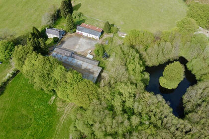
- Price
- £600,000
- Size
- 30 acres
Llanio Road, Tregaron, Llanddewi Brefi, Ceredigion SY25 Wales
Added on 30/05/2026Farm
- Price
- Offers in Region of£679,950
- Size
- 9 acres
Cilcennin, Midway Lampeter and Aberaeron, Ciliau Aeron, Ceredigion SA48 Wales
Added on 02/05/2026Smallholding