Hatton, Market Rasen
- Land size
- 3.42 acres
Key Features
- 3.42 Acres of Pastureland, Hatton, Nr. Wragby
- Offers in excess of: £50,000
Description
Willsons are pleased to bring to the market 3.42 Acres, or thereabouts, of Pastureland. The land is well shaped and in a good location.
The land benefits from direct road frontage onto the Main Road A158.
Offers in excess of: £50,000
Situation And Access - The land is situated in the Parish of Hatton fronting onto the Main Road A158 and Cow Lane which is a no through road. Originally the access was from the Main A158but more recently the land has been accessed from adjoining land. For viewing purposes a mall opening has been created on the corner of the junction to cow lane.
The land is clearly marked with a ‘For Sale’ board, positioned at the opening to the field, which should aid with identification.
What3words: noun.basics.unravel
Description - The land extends to 3.42 acres of permanent pasture and fronts onto the Main A158. It is well shaped with established hedges on four sides including mature ash trees and includes a small pond.
Tenure & Possession - The land is freehold and is being offered for sale with full vacant possession upon completion.
Services - The land has a metered water supply to a concrete livestock drinking trough.
Willsons have not tested or verified the connection of any services or equipment including fixtures and fittings.
Grade, Soil Type & Topogrpahy - The land is scheduled as Grade 3 by the Agricultural Land Classification of England and Wales. The predominant soil type in the area is Ragdale as defined by the soil survey of England and Wales. The land is undulating (ridge and furrow) in places.
Drainage Rates - Drainage rates for the land are payable to the Environment Agency on an annual basis.
Hm Land Registry - The land is registered by HM Land Registry being part of Title No. LL350496.
Underdrainage - We are not aware that the land has been underdrained.
Schedule - OS. Field No. Description Acres Hectares
8712 Permanent pasture3.42 1.384
Easements, Wayleaves & Rights Of Way - Electricity (& telephone) poles and overhead cables cross the land.
We are not aware of any other rights which affect the land, however all of the land is sold subject to and with the help and benefit of all existing rights, including rights of way whether public or private, light, support, drainage, water and electricity supplies and other rights, easements and all wayleaves whether referred to or not in these particulars.
Boundaries - The vendor will, to the best of their knowledge specify the ownership of boundaries upon request but neither the vendor nor the selling agent will be responsible for the information provided and the purchaser will be deemed to have full knowledge.
Rural Payments Agency - The land is registered on the Rural Land Register. None of the land is currently entered into any Countryside Stewardship Scheme.
Nitrate Vulnerable Zones - The land lies within a surface water S375 Nitrogen Vulnerable Zone, as designated by the Environment Agency.
Sporting, Timber & Mineral Rights - Sporting, Timber and Mineral Rights are included in the sale insofar as they are owned, subject to statutory exclusions.
Value Added Tax - The sale of the land does not currently attract VAT but in the event that the sale becomes a chargeable supply, such tax shall be payable by the purchaser in addition to the contract price.
Particulars Of Sale - These particulars including the photographs, plans, areas and schedules (which have been prepared with reference to Ordnance Survey Plans and Rural Land Register Maps) have been prepared in good faith and are only a general guide and do not form any part of an offer or contract and must be not relied upon as a statement or representation of fact. Neither Willsons nor their employees have any authority to make or give any representations or warranties whatsoever in relation to this property.
Viewing - The land may be viewed at any reasonable time during daylight hours providing a set of particulars are to hand. When viewing, interested parties are responsible for their own safety and view at their own risk.
Local Authority - Lincolnshire County Council, County Offices, Newland, Lincoln LN1 1YL, Tel:
East Lindsey District Council, The Hub, Mareham Road, Horncastle, Lincolnshire, LN9 6PH, Tel:
Lindsey Marsh Internal Drainage Board, Manby Park, Wellington House, Manby, Louth LN11 8UU, Tel:
Environment Agency, Ceres House, Searby Rd, Lincoln LN2 4DW
Anti Money Laundering - In accordance with the most recent Anti Money Laundering legislation the purchaser will be required to provide proof of identity and proof of funds to the selling agent once an offer has been submitted and accepted (subject to contract) prior to solicitors being instructed.
Map Location
Property details
- Tenure
- Freehold
- Council Tax Band
- Ask Agent
- Date Posted
- 2026-01-28
Market Value Analysis
Compared with 140 Farmland & Pasture listings in East Midlands (1+ acres).
Utilities & Restrictions
Utilities
- Electricity
- Ask Agent
- Water
- Ask Agent
- Heating
- Ask Agent
- Broadband
- Ask Agent
- Sewerage
- Ask Agent
Rights & Restrictions
- Public Rights of Way
- Ask Agent
- Private Rights of Way
- Ask Agent
- Listed Property
- Ask Agent
- Restrictions
- Ask Agent
Property Features
- Accessibility
- Ask Agent
- Parking
- Ask Agent
- Garden
- Ask Agent
Important notice: Information, maps and tags on this page are supplied by the advertising agent or generated automatically. LandSale has not verified them. Relying on these details is at your own risk, always carry out independent checks before committing to a purchase.
LandSale full disclaimer
Marketing information only - not formal particulars. The details on this website are provided for general guidance and do not constitute an offer or contract. Neither LandSale nor the advertising estate/land agent accepts responsibility for any inaccuracy.
1. Source of information
- Agent-supplied content: Core description, asking price, tenure, measurements, photographs and planning history are uploaded by the appointed agent, who remains solely responsible for their accuracy.
- Automated tags & categorisation: Property type, land-use class, acreage bands and similar labels may be applied by machine-learning models. They are intended as a helpful guide only and may not reflect the property's legal status or permitted use.
- Third-party & enriched data layers: Maps, boundary outlines, planning designations, soil reports, broadband coverage and other environmental or location-based insights are licensed from external suppliers. Such data are supplied “as is", may be incomplete or out of date and are subject to change without notice.
2. Verification required
Prospective purchasers must verify critical matters, including but not limited to planning permission, title boundaries, public rights of way, environmental constraints, acreage, services, access and VAT status, through their own inspections, specialist surveys, legal advisers and the selling agent before relying on the information or entering into any contract.
3. No warranty or liability
LandSale gives no warranty, express or implied, as to the accuracy, completeness or fitness for any particular purpose of the information displayed. LandSale shall not be liable for any loss, damage, cost or expense arising directly or indirectly from any use of or reliance on such information, save where liability may not be excluded by law.
4. Updates & feedback
If you believe any detail on this listing is inaccurate, please let us know. We will investigate and, where appropriate, update the listing or notify the agent.
© LandSale | Version 1.2 - January 2026
Listing agent
Willsons, Skegness
16 Algitha Road, Skegness, PE25 2AG
Similar properties for sale

- Price
- Offers in Region of£60,000
- Size
- 1.1 acres
Amenity Land with Development Potential, Baumber, Horncastle, Baumber, Lincolnshire LN9 5NG England
Added on 15/04/2026Undeveloped Land
- Price
- Guide Price£75,000
- Size
- 8.52 acres
Added on 29/05/2026Farmland
- Price
- Guide Price£55,000
- Size
- 6.2 acres
Added on 11/06/2026Farmland
- Price
- Guide Price£40,000
- Size
- 4.55 acres
Added on 11/06/2026Farmland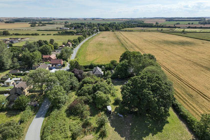
- Price
- Guide Price£50,000
- Size
- 1.5 acres
Scrub Lane, Authorpe, Authorpe, Lincolnshire LN11 8PG England
Added on 30/03/2026Vacant Land
- Price
- Guide Price£75,000
- Size
- 8.65 acres
Added on 30/05/2026Farm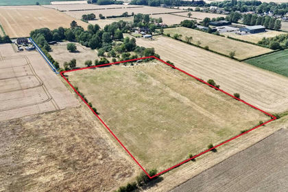
- Price
- £50,000
- Size
- 5 acres
Bishop Norton Road, Snitterby, DN21, Snitterby, Lincolnshire DN21 4TZ England
Added on 17/07/2026Grazing Land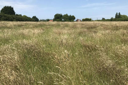
- Price
- Guide Price£50,000
- Size
- 3.53 acres
Added on 02/07/2026Pasture
- Price
- Guide Price£75,000
- Size
- 6.58 acres
Added on 05/06/2026Farmland
- Price
- Guide Price£75,000
- Size
- 5.03 acres
WINTERTON, Water Lane, DN15, Winterton, North Lincolnshire DN15 9RR England
Added on 29/01/2026Arable Land