Croes Lan, Llandysul, SA44 4SN
- Land size
- 41.5 acres
Key Features
- 41.5 ACRES
- INCLUDES 5 ACRES WOODLAND
- WELL FENCED
- PRIVATE WATER SUPPLY
- CONVENIENT LOCATION
Description
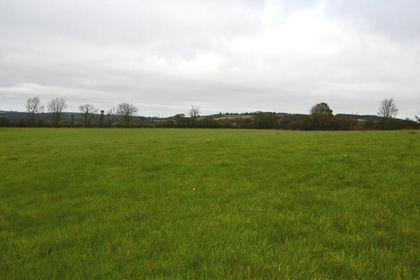
The block totals to some 41½ acres (IACS digitally measured) or thereabouts, and from the lane gateway, has an internal hardcore lane giving access to several of the pasture enclosures located on the Southern aspect of the block. The centrally located wooded area, comprises of mainly mature deciduous species, which slope down to the valley bottom, and an internal track runs up through parcel No. 2161, which links up between pasture parcel Nos. 3566 and 1767.
Pasture Parcel Nos 1940, 3336. 0852, 0563 and 1767 are level to gently sloping and in good heart. Parcel No. 3648 is level at the top (Southern end) and slopes down to its boundary with the wooded area and parcel No. 3566. Parcel No. 3566 slopes down to the valley bottom is suited for grazing only.
The enclosures are individually fenced for sheep, and a private water located at a water trough located in a strategic location, together with a natural supply in one area.
IACS/BPS
The property is currently registered for IACS purposes, and relevant BPS units are available for purchase by SEPARATE NEGOTIATION.
Rights of Way
We note from inspection of the local Ordnance Survey Map, that a public footpath runs along the access lane from the main road over to the Homestead of Pantscythan Fawr, but does not cross the subject land.
Situation Grid Ref: SN 392 - 437
The property is approached off the main A486 Llandysul - New Quay road, some 1½ miles from the market village of Llandysul which has a varied array of retail, social, leisure, and educational facilities. The village of Croeslan is some ¼ mile distant and has a grocery. The Market Town of Newcastle Emlyn is some 6½ miles distant.
TENURE - Advised Freehold.
SERVICES - Advised private water supply connected.
DIRECTIONS
From the Horeb Crossroads on the A486 (with junctions off onto the A475 Newcastle Emlyn/Lampeter road), stay on the A486 heading North towards Ffostrasol. You'll pass a car repair garage on the right hand side, and after climbing up the incline, you'll go down and see a pair of Semi-Detached Houses on the right hand side. The entrance onto the access lane is immediately alongside the 2nd of the pair, and with a Dai Lewis pointer sign located here. Turn onto the lane, and carry on until coming to a pair of double gates (opposite 'Hazevern Court') with our 'For Sale' sign erected.
Land formerly of Pantscythan Fawr.
(Figures taken from Welsh Government 2024 Field Data and converted from Hectares to Acres)
OS. NO. ACREAGE REMARKS
1940 4.69
3336 3.80
3648 8.80
2153 2.25 TO INC. 0.10 TRACK AND 1.93 WOOD
0852 3.98 TO INC. 0.17 TRACK AND 0.17 WOOD
0563 3.58
1767 2.77
2161 1.23 WOOD
2974 2.57 TO INC. 2.00 WOOD
3566 7.83 TO INC 0.22 WOOD
41.50
Summary
35.68 Claimable/Usable
0.27 Track
5.55 Wood
Map Location
Property details
- Tenure
- Ask Agent
- Council Tax Band
- Ask Agent
- Date Posted
- 2026-01-29
Market Value Analysis
Compared with 96 Farmland & Pasture listings in Wales (25+ acres).
Utilities & Restrictions
Utilities
- Electricity
- Ask Agent
- Water
- Ask Agent
- Heating
- Ask Agent
- Broadband
- Ask Agent
- Sewerage
- Ask Agent
Rights & Restrictions
- Public Rights of Way
- Ask Agent
- Private Rights of Way
- Ask Agent
- Listed Property
- Ask Agent
- Restrictions
- Ask Agent
Property Features
- Accessibility
- Ask Agent
- Parking
- Parking Available
- Garden
- Ask Agent
Important notice: Information, maps and tags on this page are supplied by the advertising agent or generated automatically. LandSale has not verified them. Relying on these details is at your own risk, always carry out independent checks before committing to a purchase.
LandSale full disclaimer
Marketing information only - not formal particulars. The details on this website are provided for general guidance and do not constitute an offer or contract. Neither LandSale nor the advertising estate/land agent accepts responsibility for any inaccuracy.
1. Source of information
- Agent-supplied content: Core description, asking price, tenure, measurements, photographs and planning history are uploaded by the appointed agent, who remains solely responsible for their accuracy.
- Automated tags & categorisation: Property type, land-use class, acreage bands and similar labels may be applied by machine-learning models. They are intended as a helpful guide only and may not reflect the property's legal status or permitted use.
- Third-party & enriched data layers: Maps, boundary outlines, planning designations, soil reports, broadband coverage and other environmental or location-based insights are licensed from external suppliers. Such data are supplied “as is", may be incomplete or out of date and are subject to change without notice.
2. Verification required
Prospective purchasers must verify critical matters, including but not limited to planning permission, title boundaries, public rights of way, environmental constraints, acreage, services, access and VAT status, through their own inspections, specialist surveys, legal advisers and the selling agent before relying on the information or entering into any contract.
3. No warranty or liability
LandSale gives no warranty, express or implied, as to the accuracy, completeness or fitness for any particular purpose of the information displayed. LandSale shall not be liable for any loss, damage, cost or expense arising directly or indirectly from any use of or reliance on such information, save where liability may not be excluded by law.
4. Updates & feedback
If you believe any detail on this listing is inaccurate, please let us know. We will investigate and, where appropriate, update the listing or notify the agent.
© LandSale | Version 1.2 - January 2026
Listing agent
Dai Lewis, Newcastle Emlyn
Newcastle Emlyn Sycamore Street, Newcastle Emlyn, SA38 9AJ
Contact Dai Lewis, Newcastle Emlyn
Newcastle Emlyn Sycamore Street, Newcastle Emlyn, SA38 9AJ
View agent profileSimilar properties for sale
- Price
- Offers Over£280,000
- Size
- 37.5 acres
Ffostrasol, Llandysul, Ceredigion. SA44 5JS, Troedyraur, Ceredigion SA44 5JS Wales
Added on 29/01/2026Farmland
- Price
- £285,000
- Size
- 29 acres
Bancyffordd, Llandysul, SA44, Llangeler, Carmarthenshire SA44 4RY Wales
Added on 30/05/2026Farmland
- Price
- Offers in Excess of£300,000
- Size
- 30.17 acres
Talgarreg, Llandysul. SA44 4EU, Llandysiliogogo, Ceredigion SA44 4EU Wales
Added on 29/01/2026Pasture
- Price
- £300,000
- Size
- 20 acres
Added on 29/01/2026Agricultural Land
- Price
- Offers in Region of£320,000
- Size
- 32 acres
Rhos, Llandysul .SA44 5AH, Llangeler, Carmarthenshire SA44 5AH Wales
Added on 28/01/2026Pasture
- Price
- Offers in Excess of£250,000
- Size
- 34.5 acres
Cwmduad, Carmarthen. SA33 6AT, Cynwyl Elfed, Carmarthenshire SA33 6AT Wales
Added on 29/01/2026Agricultural Land
- Price
- Offers in Region of£290,000
- Size
- 30 acres
Delfryn, Newcastle Emlyn, Carmarthenshire, Cenarth, Carmarthenshire SA38 9RJ Wales
Added on 07/07/2026Agricultural Land
- Price
- £295,000
- Size
- 25 acres
Glantren Lane, Llanybydder, SA40, Llanybydder, Carmarthenshire SA40 9SA Wales
Added on 02/04/2026Farmland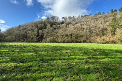
- Price
- Guide Price£260,000
- Size
- 54.4 acres
Added on 29/01/2026Woodland
- Price
- Offers in Region of£342,000
- Size
- 38 acres
Llanboidy, Whitland, SA34, Llanboidy, Carmarthenshire SA34 0EX Wales
Added on 10/05/2026Farm