Far End Lane, Honley, Holmfirth
- Bedrooms
- 2
- Bathrooms
- 2
Key Features
- Grade II Listed Barn Conversion
- Two Bedrooms
- Character And Charm
- Courtyard Setting With Seating Area
- Spacious Open Plan Lounge/Dining Area
- Two Allocated Parking Spaces
- Backing On To Honley Cricket Ground
- Closeby To The Vibrant Honley Village
Description
SUMMARY
***SET IN THE HEART HONLEY*** is this charming grade II restored barn conversion. Set to this beautiful courtyard position, with a delightful seating area. TWO ALLOCATED PARKING SPACES. TWO BEDROOMS, spacious OPEN PLAN lounge/diner. En suite to master bedroom. Backing onto Honley cricket club.
DESCRIPTION
Honley is a village in the Holme valley and is situated near to Holmfirth and Huddersfield. On the banks of the River Holme Honley has an abundance of shops, bars, restaurants and local amenities. with the added benefit of a local railway station. Its popular schooling is well renowned,and there are good motorway network links. A short drive into Holmfirth town,
Summary
A fantastic opportunity to acquire this charming two bedroom barn conversion located to this courtyard setting. With Victorian brick work to the front and feature barn window. Characterful features internally, including ceiling beams, trusses and recessed brick fireplace and chimney. Further enhanced by a proportion of the courtyard seating area, with its attractive pot plants and two allocated parking spaces. Backing onto Honley Cricket ground to the rear. The property would be ideally suited to a professional couple or downsize. The accommodation is upside down and briefly comprising of spacious entrance hallway, two bedrooms, master en suite and house bathroom. To first floor is a spacious open plan lounge/diner and kitchen. Located to the sought after vibrant village of honley with its wealth of shops, wine bars, restaurants along with the train station and well regarded schooling. Further benefiting from being a short drive into the Holmfirth town centre.
Accommodation
Entrance Hallway
Enter into spacious hallway, with slate flooring and inset down lights to ceiling. Attractive built in grey storage offers a modern touch. Radiator.
Master Bedroom 13' 5" x 10' ( 4.09m x 3.05m )
Spacious double bedroom with laminate floor covering. coving to ceiling. Three double glazed windows. Useful understairs storage. Radiator.
En Suite
Three-piece suite comprising of corner shower with mosaic style tiles, pedestal wash hand basin and low flush WC. Paneled ceiling with inset down lights. Obscured double glazed window.
Bedroom Two 12' 1" x 9' 2" ( 3.68m x 2.79m )
This bedroom oozes storage, with a bank of built in wardrobes, complimented by high bed. Anthracite radiator. Double glazed window overlooking the cricket ground.
House Bathroom
Attractive bathroom suite, with deep bath, with feature tiling. Vanity sink and built in WC. Partial tiled walls with inset down lights to ceiling. Chrome style radiator.
First Floor
Timber staircase leading to first floor.
Lounge/Dining Space 29' 1" x 16' 7" ( 8.86m x 5.05m )
This spacious L-shaped lounge dinner offers character and charm. With solid oak floor covering, and ceiling trusses. The real focal point being the recessed brick fireplace and exposed brick chimney with gas stove. The dining table is positioned to look over onto the courtyard with the double glazed barn window offering character.
Kitchen 9' 2" x 8' 3" ( 2.79m x 2.51m )
With a good range of wood style wall and base units, complimented by dishwasher, plumbing for washing machine, Gas Hob with extractor over and oven. Also housing the Maxi boiler. Velux window.
External
To the front of the property is a blocked paved courtyard, which this property benefits from owning a proportion of. Making this an ideal space to sit and enjoy the setting. The property is further enhanced by two allocated parking spaces.
DIRECTIONS
Leave Holmfirth via Huddersfield Road and proceed towards Honley. Turn left up Hagg Wood Road and Right on to Gib Lane and immediate right on to Far Banks which becomes Far End Lane where the property can be identified by our for sale board outside.
1. MONEY LAUNDERING REGULATIONS: Intending purchasers will be asked to produce identification documentation at a later stage and we would ask for your co-operation in order that there will be no delay in agreeing the sale.
2. General: While we endeavour to make our sales particulars fair, accurate and reliable, they are only a general guide to the property and, accordingly, if there is any point which is of particular importance to you, please contact the office and we will be pleased to check the position for you, especially if you are contemplating travelling some distance to view the property.
3. The measurements indicated are supplied for guidance only and as such must be considered incorrect.
4. Services: Please note we have not tested the services or any of the equipment or appliances in this property, accordingly we strongly advise prospective buyers to commission their own survey or service reports before finalising their offer to purchase.
5. THESE PARTICULARS ARE ISSUED IN GOOD FAITH BUT DO NOT CONSTITUTE REPRESENTATIONS OF FACT OR FORM PART OF ANY OFFER OR CONTRACT. THE MATTERS REFERRED TO IN THESE PARTICULARS SHOULD BE INDEPENDENTLY VERIFIED BY PROSPECTIVE BUYERS OR TENANTS. NEITHER SEQUENCE (UK) LIMITED NOR ANY OF ITS EMPLOYEES OR AGENTS HAS ANY AUTHORITY TO MAKE OR GIVE ANY REPRESENTATION OR WARRANTY WHATEVER IN RELATION TO THIS PROPERTY.
Map Location
Property details
- Tenure
- Freehold
- Council Tax Band
- C
- Date Posted
- 2026-01-29
Utilities & Restrictions
Utilities
- Electricity
- Ask Agent
- Water
- Ask Agent
- Heating
- Ask Agent
- Broadband
- Ask Agent
- Sewerage
- Ask Agent
Rights & Restrictions
- Public Rights of Way
- Ask Agent
- Private Rights of Way
- Ask Agent
- Listed Property
- Ask Agent
- Restrictions
- Ask Agent
Listed status, conservation areas and planning constraints for this location are in the full report.
Property Features
- Accessibility
- Ask Agent
- Parking
- Off-Street Parking
- Garden
- Patio
Beyond the particulars: planning activity, flood history, heritage and ground risks, checked for this exact spot.
Connectivity
Broadband
Fastest speed available at this postcode
1.8 Gbps
Gigabit full fibre
Suitable for
- 4K streaming on every screen
- Full-time home working
- Online gaming & big downloads
Mobile signal
Outdoor predictions; indoor signal depends on building materials.
Ofcom Connected Nations postcode-level predictions. Speeds and signal are modelled, not measured, and vary between addresses and providers.
Signal is the easy part. Planning activity, flood history and protected designations here are in the full report.
Nearest Schools
Primary
- Honley CofE (VC) Junior, Infant and Nursery School236 metresOfsted: Good
- Ages
- 4 to 11
- Pupils
- 373
- Type
- Voluntary controlled school
- Faith
- Church of England
- Brockholes Church of England Voluntary Controlled Junior and Infant School0.9 milesOfsted: Outstanding
- Ages
- 4 to 11
- Pupils
- 210
- Type
- Voluntary controlled school
- Faith
- Church of England
- Netherton Infant and Nursery School1.2 milesNo Ofsted rating
- Ages
- 3 to 7
- Pupils
- 204
- Type
- Academy converter
- Netherthong Primary School1.2 milesOfsted: Good
- Ages
- 4 to 11
- Pupils
- 213
- Type
- Community school
- South Crosland Church of England Voluntary Aided Junior School1.3 milesNo Ofsted rating
- Ages
- 7 to 11
- Pupils
- 228
- Type
- Voluntary aided school
- Faith
- Church of England
Secondary
- Honley High School737 metresNo Ofsted rating
- Ages
- 11 to 16
- Pupils
- 1,240
- Type
- Academy converter
- Holmfirth High School1.5 milesOfsted: Outstanding
- Ages
- 11 to 16
- Pupils
- 1,328
- Type
- Community school
- Newsome Academy1.6 milesOfsted: Good
- Ages
- 11 to 16
- Pupils
- 824
- Type
- Academy sponsor led
- Moor End Academy2.2 milesOfsted: Outstanding
- Ages
- 11 to 16
- Pupils
- 1,053
- Type
- Academy converter
- King James's School2.7 milesOfsted: Good
- Ages
- 11 to 16
- Pupils
- 1,055
- Type
- Academy converter
Distances are straight-line from the advertised location. Source: the national school registers (DfE, Welsh Government, Scottish Government) and Ofsted.
Schools are just the start: sold prices nearby, planning activity and any flood history are in the full report.
Amenities
Supermarket
GP surgery
Pharmacy
Hospital
Green space
Straight-line distances from the advertised location. Sources: NHS records, Geolytix supermarket locations, OS Open Greenspace and the national trails registers.
The area stacks up? Now check the location itself: planning nearby, protected designations and past flooding.
Getting Around
Nearest station
Nearest bus stop
Typical drive times
Straight-line distances from the advertised location; drive times are typical free-flow times over OpenStreetMap road data, so allow more at peak. Public transport locations from DfT NaPTAN.
Easy to reach matters. So do planning activity, flood history and ground risks: all in the full report.
Flood Risk
From Environment Agency flood map open data, checked around the advertised map pin and allowing for the listed acreage where known. This summary comes from LandSale, the advertising platform, not from the listing agent, and is not part of the agent's particulars. Risk can vary across a single holding, so verify anything critical through your own searches before committing.
Rivers and the sea
Surface water
The detail behind these bandings
The full report pinpoints where this location sits on the flood maps, and runs the deeper checks that usually only surface after an offer.
- Exact flood zones & annual chances (included in the full report)
- Any recorded past flooding (included in the full report)
- Planning activity nearby (included in the full report)
- Heritage & conservation (included in the full report)
- Protected nature designations (included in the full report)
- Ground risks (included in the full report)
- Sold prices nearby (included in the full report)
£14.99 · one-off purchase
By LandSale, the platform. Not provided by the listing agent. Ready in about a minute.
Important notice: Information, maps and tags on this page are drawn from the advertising agent's marketing materials or generated automatically. LandSale has not verified them. Relying on these details is at your own risk, always carry out independent checks before committing to a purchase.
LandSale full disclaimer
Marketing information only - not formal particulars. The details on this website are provided for general guidance and do not constitute an offer or contract. Neither LandSale nor the advertising estate/land agent accepts responsibility for any inaccuracy.
1. Source of information
- Listing content: Core description, asking price, tenure, measurements, photographs and planning history originate from the marketing materials of the advertising estate or land agent. LandSale does not author this content and cannot guarantee its accuracy.
- Automated tags & categorisation: Property type, land-use class, acreage bands and similar labels may be applied by machine-learning models. They are intended as a helpful guide only and may not reflect the property's legal status or permitted use.
- Third-party & enriched data layers: Maps, boundary outlines, planning designations, soil reports, broadband coverage and other environmental or location-based insights are licensed from external suppliers. Such data are supplied “as is", may be incomplete or out of date and are subject to change without notice.
2. Verification required
Prospective purchasers must verify critical matters, including but not limited to planning permission, title boundaries, public rights of way, environmental constraints, acreage, services, access and VAT status, through their own inspections, specialist surveys, legal advisers and the selling agent before relying on the information or entering into any contract.
3. No warranty or liability
LandSale gives no warranty, express or implied, as to the accuracy, completeness or fitness for any particular purpose of the information displayed. LandSale shall not be liable for any loss, damage, cost or expense arising directly or indirectly from any use of or reliance on such information, save where liability may not be excluded by law.
4. Updates & feedback
If you believe any detail on this listing is inaccurate, please let us know. We will investigate and, where appropriate, update the listing or notify the agent.
© LandSale | Version 1.3 - August 2026
Listing agent
William H. Brown, Holmfirth
34 Victoria Street, Holmfirth, Huddersfield, HD9 7DE
View agent profileSimilar properties for sale
- Price
- Offers Over£250,000
Land to the rear of 41 Quarmby Road, Huddersfield, Colne Valley, Kirklees HD3 England
Added on 29/01/2026Building Plot Added on 30/07/2026Barn Conversion
- Price
- Offers Over£325,000
South View Fold, Penistone, Sheffield, S36, Gunthwaite and Ingbirchworth, Barnsley S36 England
Added on 17/03/2026Barn Conversion
- Price
- Offers in Region of£250,000
Victoria Street, Clayton West, HD8, Denby Dale, Kirklees HD8 England
Added on 05/06/2026Building Plot
- Price
- Offers Over£285,000
Woolley Manor Barn, Blackergreen Lane, Silkstone, Barnsley, S75, Silkstone, Barnsley S75 England
Added on 27/08/2026Barn Conversion
- Price
- £260,000
- Size
- 3 acres
Added on 17/07/2026Development Land
- Price
- Offers in Region of£260,000
Barnsley Road, Darton, Barnsley, Barnsley North, Barnsley S75 England
Added on 17/06/2026Barn Conversion
- Price
- Offers Over£250,000
The Courtyard, Woolley, Wakefield, Woolley, Wakefield WF4 England
Added on 27/02/2026Barn Conversion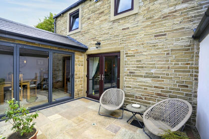 Added on 25/07/2026Barn Conversion
- Price
- £295,000
- Size
- 0.6 acres
Stubley View, Featherstall Road, Littleborough, OL15, Rochdale, Rochdale OL15 England
Added on 29/01/2026Development Land