Bonthorpe Lane, Willoughby LN13
- Land size
- 1.28 acres
Key Features
- Building Plot with 1.28 acre grounds
- Attractive mature tree-lined setting
- Full planning permission for 4-bed detached house + double garage
- Parkland setting on village outskirts
- Potential for domestic or equestrian use only
Description
Enjoying a mature tree-lined setting with 1.28-acre grounds, this exceptional building plot is close to the Church of St. Helena and has full planning permission for a detached 4 bedroom family house with an attached double garage. The grounds enjoy a "parkland" environment in a quiet location on the village outskirts with potential for domestic garden or equestrian use only (STP).
About the Plot.....
Directions From Alford take the B1196 south for around 3.5 miles which culminates in the centre of Willoughby village. Bear left along Church Lane immediately before the Willoughby Arms pub. Go past the church set back on the right (the lane becomes Bonthorpe Road) and the plot will then be found immediately after the barns which stand along the lane side on the right, The grounds of the plot continue for some distance around the sweep of the lane, with traditional metal post and rail fencing, as far as the grand entrance into the large neighbouring house.
Planning Full planning permission was granted by the East Lindsey District Council on the 27th of November 2019 for the detached house and attached garage in conjunction with other adjoining development. Applicants should satisfy themselves regarding planning matters by visiting the planning portal of the ELDC website and searching for application number N/208/00615/18 where a copy of the decision notice and accompanying plans/documents can be found and downloaded. NB a covenant will be imposed restricting the use of the adjoining buildings to residential use and not for any commercial use as previously approved.
Method of Sale The land is for sale by Private Treaty.
The Proposed Dwelling The architect's approved design as shown in the elevations is for a traditional detached family house with an attached double garage and independent access to a home office above. The illustrated front elevation above is shown with an attractive golden brickwork colour reflecting the local "Farlesthorpe Brick" which can be found in many local buildings.
The house will enjoy an exceptional setting with a current parkland feel but offering potential to keep a pony, enjoy horticultural pursuits, create a small hobby farm or consider leisure use, subject to planning permission.
The grounds are enclosed by some fine, mature native trees with typically traditional iron post and rail fencing along the lane side.
The house will provide excellent family accommodation if built in accordance with the approved plans and a brief description with approximate room sizes scaled from the plans, is described below.
Accommodation
Ground Floor Main entrance at the front of the house shown on the elevations with a pillared entrance and 4-panelled front door into the:
Entrance Hall 4.61m x 2.35m (15'1" x 7'8") To include staircase with side screen or balustrade as required and an understairs cupboard accessed from the kitchen. A good size reception area with doors leading off to the living room at the front of the house, the study, the kitchen at the rear and a door at the side to the:
Cloakroom/WC 2.6m x 0.91m (8'6" x 6'3") With space for a suite comprising low-level WC and bracket or vanity wash hand basin, together with light-operated extractor fan.
Living Room 5.87m x 4.61m (19'3" x 15'1") Positioned at the front of the house with two windows on the front elevation and of excellent size.
Study 2.6m x 1.91m (8'6" x 6'3") Also positioned at the front of the property with window on the front elevation.
L-Shaped Dining/Living Kitchen 11.12m x 5.47m in the living area and 3.16m in the kitchen area (36'5" x 17'11" in the living area and 10'4" in the kitchen area)
The architect's drawings show a spacious kitchen area designed for an L-shaped range of base and wall units with two windows on the rear elevation, extensive work surfaces and ample space to incorporate built-in appliances. A door leads from this area to the utility room adjacent and the kitchen is open plan with the dining and living area beyond – an excellent size with two windows to the side elevation overlooking the parkland, single window to the opposite side elevation and rear single window, together with French doors opening onto the patio and garden areas.
Utility Room 2.6m x 1.5m (8'6" x 4'11") Shown on the plans with space for units to the side and recess with plumbing for washing machine, together with any further appliances required. The utility room has a connecting door to the attached double garage.
First Floor Landing 5.12m max. x 3.9m max. (17'5" max. x 12'9" max.)
A spacious landing with two large, built-in linen/storage cupboards, window on the rear elevation and balustrade or side screen adjoining the top steps of the staircase on each side. Further doors lead off to the four double bedrooms and the family bathroom.
Bedroom 1 (rear) 5.21m x 3.83m (17’1” x 12’6”) A spacious double bedroom with ample space as shown on the floor plan for built-in wardrobes and other furniture. Two windows to the rear elevation and connecting door to the:
En Suite Shower Room 2.82m x 1.7m (9'3" x 5'6") Shown with space for a wide shower cubicle and a suite comprising a vanity or pedestal wash hand basin and low-level WC; window on the side elevation.
Bedroom 2 (front) 4.44m x 3.55m plus wide recess (14'6" x 11'5" plus wide recess)
Another good size bedroom, also shown on the plans with ample space for built-in bedroom furniture and having a window on the front elevation.
Bedroom 3 (rear) 4.13m x 2.84m (13’6” x 9’3”) A smaller double bedroom or, as shown on the floor plan, a good size single bedroom with ample space for built-in furniture and a window on the rear elevation.
Bedroom 4 (front) 4.62m/4.02m x 3.71m (15’2”/13’2” x 12’2”) An ideal guest bedroom with window on the front elevation, a recess to the side suitable for a built-in wardrobe and a connecting door to the:
En Suite Shower Room 3.05m x 2m (10' x 6'6") Positioned over the adjoining garage, the shower room has space for a shower cubicle, suite of low-level WC and wash basin as required and a skylight window to the rear roof slope.
Garage Wing
Ground Floor Double Garage 5.72m x 5.46m plus workshop recess (18'9" xc 17'11" plus recess)
An excellent size and shown on the floor plans as having two pairs of double doors on the rear elevation and a window on the front elevation.
Independent Entrance Lobby and doorway to the first-floor office.
With staircase and side screen having kite-winder upper steps and door into the:
First Floor Home Office With part-sloping ceiling having a skylight window on the rear slope and ample space for furniture – a comfortable setting for working from home.
Outside he grounds afford potential to create formal gardens with hard and soft landscaping around the house with driveway to be surfaced from the lane by the purchaser/s and accessed via a vehicular and pedestrian right of way over the area shown blue on the site plan subject to shared maintenance of that area according to user. There is ample space in the paddock for outbuildings (possible stable for a pony shown on the site plan) subject to planning permission as required. NB – The new owner/s will be required to erect and forever after maintain boundary fencing of type to be specified within 3 months of completion.
Viewing The plot can be viewed from Church Lane, you may enter the site on foot only during daylight hours by following the private lane from the parking area in front of the church. Please contact the selling agent for further information on viewing and to register your interest.
Council Tax and Business Rates The property is not recorded on the East Lindsey District Council website for council tax purposes but any residential occupation such as that for which permission has been granted would alter this position.
Sporting and Mineral Rights These are included in the sale where they are owned.
Wayleaves, Easements, Covenants and Rights of Way The land is sold subject to and with the benefit of all existing wayleaves, easements and quasi-easements and rights of way, whether mentioned in these particulars or not.
Tenure The land is offered for sale freehold with vacant possession on completion.
General Information The particulars of this property are intended to give a fair and substantially correct overall description for the guidance of intending purchasers. Plans/Maps are not to specific scale, are based on information supplied and subject to verification by a solicitor at sale stage. It is anticipated that the new dwelling will be connected to mains electricity and water available in the village– applicants should satisfy themselves as to the precise position and accessibility of these services.
NB The contract will specify a single dwelling only on the plot and a covenant restricting the use of the paddock to residential or equestrian only (STP)
Location Willoughby is an interesting village positioned on the eastern edge of the Lincolnshire Wolds and around 3 miles south of Alford market town, and 12 miles from the seaside resort of Skegness. The plot stands in a mature setting with a nearby Manor House of note and the church grounds include a substantial rectory.
Local children are taught about John Smith who was born and raised in Willoughby in the 16th Century and went on to become one of the leaders of the Virginia Colony in North America with recorded connections to Pocahontas.
In 1970, the east Lincolnshire Railway was closed having connected the village to Peterborough and Grimsby with a line to Mablethorpe – as in other local parts of Lincolnshire there is some typical railway architecture to be seen.
There is a strong community spirit with events sponsored by the village hall and green including an annual summer fair. There is a village primary school, a petrol station with store, a public house and a regular visiting mobile fish and chip van.
General Information The particulars of this property are intended to give a fair and substantially correct overall description for the guidance of intending purchasers. No responsibility is to be assumed for individual items.
Any Plans/Maps are not to specific scale, are based on information supplied and subject to verification by a solicitor at sale stage. Applicants should satisfy themselves as to the position and accessibility of mains services.
The red-lined aerial image shows the approximate position of the boundaries and should be verified against the contract plan at sale stage.
Floor plans and elevations are taken from the approved architect's drawings showing approximate intended dimensions. BDLD
Map Location
Property details
- Tenure
- Freehold
- Council Tax Band
- Ask Agent
- Date Posted
- 2026-01-29
Market Value Analysis
Compared with 22 Building Plots listings in East Midlands (1+ acres).
Property Brochure
Seen the details? The full report adds the independent checks: planning activity, flood history, heritage and ground.
Utilities & Restrictions
Utilities
- Electricity
- Ask Agent
- Water
- Ask Agent
- Heating
- Ask Agent
- Broadband
- Ask Agent
- Sewerage
- Ask Agent
Rights & Restrictions
- Public Rights of Way
- Ask Agent
- Private Rights of Way
- Ask Agent
- Listed Property
- Ask Agent
- Restrictions
- Ask Agent
Listed status, conservation areas and planning constraints for this location are in the full report.
Property Features
- Accessibility
- Ask Agent
- Parking
- Parking Available
- Garden
- Garden
Beyond the particulars: planning activity, flood history, heritage and ground risks, checked for this exact spot.
Connectivity
Broadband
Fastest speed available at this postcode
1 Gbps
Gigabit full fibre
Suitable for
- 4K streaming on every screen
- Full-time home working
- Online gaming & big downloads
Mobile signal
Predicted 4G and 5G signal; indoor signal depends on building materials.
Ofcom Connected Nations postcode-level predictions. Speeds and signal are modelled, not measured, and vary between addresses and providers.
Signal is the easy part. Planning activity, flood history and protected designations here are in the full report.
Nearest Schools
Primary
- St Helena's Church of England Primary Academy, Willoughby278 metresOfsted: Good *
- Ages
- 3 to 11
- Pupils
- 145
- Type
- Academy converter
- Faith
- Church of England
- Alford Primary School2.4 milesNo Ofsted rating
- Ages
- 4 to 11
- Pupils
- 304
- Type
- Community school
- Huttoft Primary & Nursery School3.6 milesOfsted: Good *
- Ages
- 2 to 11
- Pupils
- 147
- Type
- Academy converter
- Hogsthorpe Primary Academy3.9 milesOfsted: Good
- Ages
- 4 to 11
- Pupils
- 46
- Type
- Academy converter
- Partney Church of England Aided Primary School4.4 milesOfsted: Requires improvement *
- Ages
- 3 to 11
- Pupils
- 63
- Type
- Voluntary aided school
- Faith
- Church of England
Secondary
- John Spendluffe Foundation Technology College2.5 milesOfsted: Good
- Ages
- 11 to 16
- Pupils
- 650
- Type
- Academy converter
- Queen Elizabeth's Grammar Alford - A Selective Academy2.7 milesOfsted report card · May 2026
- Ages
- 11 to 18
- Pupils
- 565
- Type
- Academy converter
- King Edward VI Academy5.8 milesOfsted: Good
- Ages
- 11 to 16
- Pupils
- 357
- Type
- Academy sponsor led
- Skegness Academy7.3 milesOfsted: Requires improvement
- Ages
- 11 to 19
- Pupils
- 939
- Type
- Academy sponsor led
- Skegness Grammar School7.5 milesOfsted report card · May 2026
- Ages
- 11 to 18
- Pupils
- 622
- Type
- Academy converter
* Latest graded judgement covers quality of education only; no overall grade was issued under the 2024-25 inspection framework.
Distances are straight-line from the advertised location. Source: the national school registers (DfE, Welsh Government, Scottish Government) and Ofsted.
Schools are just the start: sold prices nearby, planning activity and any flood history are in the full report.
Amenities
Supermarket
GP surgery
Pharmacy
Hospital
Green space
Straight-line distances from the advertised location. Sources: NHS records, Geolytix supermarket locations, OS Open Greenspace and the national trails registers.
The area stacks up? Now check the location itself: planning nearby, protected designations and past flooding.
Getting Around
Nearest station
Nearest bus stop
Typical drive times
Straight-line distances from the advertised location; drive times are typical free-flow times over OpenStreetMap road data, so allow more at peak. Public transport locations from DfT NaPTAN.
Easy to reach matters. So do planning activity, flood history and ground risks: all in the full report.
Flood Risk
Environment Agency open data, checked around the advertised map pin for the listed acreage. Long-term risk counts flood defences; the planning map's flood zones do not. Provided by LandSale, not the listing agent, and not part of the agent's particulars. Risk varies across a holding, so verify before committing.
Rivers and the sea
Planning map: Flood Zone 2, about 40 metres away.
Surface water
Not at the pin: mapped about 40 metres away.
These bandings are the summary. Where this location sits on the flood maps, plus planning activity, heritage and ground risks, is in the full report.
Important notice: Information, maps and tags on this page are drawn from the advertising agent's marketing materials or generated automatically. LandSale has not verified them. Relying on these details is at your own risk, always carry out independent checks before committing to a purchase.
LandSale full disclaimer
Marketing information only - not formal particulars. The details on this website are provided for general guidance and do not constitute an offer or contract. Neither LandSale nor the advertising estate/land agent accepts responsibility for any inaccuracy.
1. Source of information
- Listing content: Core description, asking price, tenure, measurements, photographs and planning history originate from the marketing materials of the advertising estate or land agent. LandSale does not author this content and cannot guarantee its accuracy.
- Automated tags & categorisation: Property type, land-use class, acreage bands and similar labels may be applied by machine-learning models. They are intended as a helpful guide only and may not reflect the property's legal status or permitted use.
- Third-party & enriched data layers: Maps, boundary outlines, planning designations, soil reports, broadband coverage and other environmental or location-based insights are licensed from external suppliers. Such data are supplied “as is", may be incomplete or out of date and are subject to change without notice.
2. Verification required
Prospective purchasers must verify critical matters, including but not limited to planning permission, title boundaries, public rights of way, environmental constraints, acreage, services, access and VAT status, through their own inspections, specialist surveys, legal advisers and the selling agent before relying on the information or entering into any contract.
3. No warranty or liability
LandSale gives no warranty, express or implied, as to the accuracy, completeness or fitness for any particular purpose of the information displayed. LandSale shall not be liable for any loss, damage, cost or expense arising directly or indirectly from any use of or reliance on such information, save where liability may not be excluded by law.
4. Updates & feedback
If you believe any detail on this listing is inaccurate, please let us know. We will investigate and, where appropriate, update the listing or notify the agent.
© LandSale | Version 1.3 - August 2026

Listing agent
Masons Sales, Louth
Cornmarket, Louth, LN11 9QD
Similar properties for sale
- Price
- Guide Price£125,000
- Size
- 0.24 acres
Development Site, Off Ranters Row, Alford, Lincolnshire, LN13, Alford, Lincolnshire LN13 England
Added on 29/01/2026Development Land Added on 21/07/2026Development Land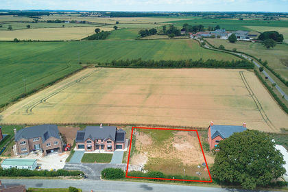
- Price
- Guide Price£165,000
- Size
- 0.28 acres
Plot 5, Tothby Lane, Alford, Alford, Lincolnshire LN13 England
Added on 29/01/2026Building Plot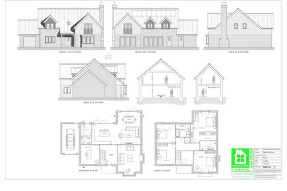
- Price
- Fixed Price£130,000
Plot 2, Skegness Road, Partney, Partney, Lincolnshire PE23 England
Added on 07/02/2026Building Plot
- Price
- From£115,000
Added on 05/06/2026Building Plot
- Price
- Guide Price£185,000
- Size
- 10 acres
Alford Road, Sutton on Sea, Lincolnshire, LN12, Mablethorpe and Sutton, Lincolnshire LN12 England
Added on 29/01/2026Undeveloped Land
- Price
- Offers in Region of£140,000
Building Plot, The Gables, Hundleby, Hundleby, Lincolnshire PE23 England
Added on 02/04/2026Building Plot
- Price
- £145,000
- Size
- 0.5 acres
Added on 19/03/2026Building Plot Added on 22/06/2026Building Plot
- Price
- Guide Price£140,000
- Size
- 0.5 acres
Main Road, Toynton All Saints, PE23, Toynton All Saints, Lincolnshire PE23 England
Added on 17/07/2026Redevelopment Land