Plot 5, Tothby Lane, Alford
- Land size
- 0.28 acres
- Bedrooms
- 4
- Bathrooms
- 3
Key Features
- Unique Opportunity for executive building plot
- Plot with full planning consent for sale as an individual plot
- Sought after edge of town location
- Freehold with vacant possession upon completion
- No BNG requirements
- Unique opportunity to acquire executive style
- PART serviced building plot
- Plot Five - 0.28 acres
- For Sale by Private Treaty
Description
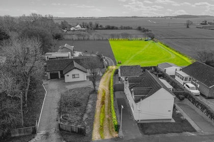
The vendor offers the opportunity to acquire the final superb detached plot set to the edge of Alford Town whilst giving the feeling of being in the open countryside. The plot is offered for sale on a unique executive development and all plots benefit from full planning permission (N/003/00166/20) with all other Plots 1-4 now sold and under construction to private individuals.
The plot is generous in size with ample garden space and an attached garage benefitting from countryside views across the adjacent fields to the rear.
Plot 5 stands in 0.28 acres and comprises of plans for a four bedroomed detached dwelling of 310square metres. Ample living space has been provided with an open plan kitchen diner alongside three reception rooms. Upstairs there are two double bedrooms with dressing rooms and ensuite facilities and a further two double bedrooms.
As shown on the indicative sketches Plot 5 has a shared private driveway gaining access to the individual plot. The maintenance of the shared area is to be split on a 25% basis with Plots 2-4 upon completion of the sale.
LOCATION The plot is located on the western edge of Alford town, benefitting from a countryside location within walking distance to the towns amenities. Alford is a market town consisting of pubs, shops, supermarket, garage and an array of other services with good links to the nearby A16 trunk road giving easy access to Louth and Skegness.
SERVICES All plots will benefit from being part serviced up to connection points. The access points have been installed by the current vendor.
PLANNING Full planning permission was granted by ELDC under application number N/003/00166/20 for the erection of 4no. detached houses with integral garage, 1no. pair of semi detached houses with attached single garages and 1no. block of 4no. Flats. Construction of vehicular accesses and vehicular parking areas.
Please note 1no. detached house and 1no. block of 4no. flats (edged brown) will be retained by the current vendor. Please note Plots 1-4 have now been sold and construction is nearly complete.
TENURE Freehold with vacant possession upon completion.
ALFORD Alford is a picturesque market town in Lincolnshire, located at the foot of the Lincolnshire Wolds and close to the east coast. Known for its historic charm and strong community spirit, it features landmarks such as the five-sailed Alford Windmill, the thatched Alford Manor House, and the medieval St Wilfrid's Church. The town hosts regular markets, craft fairs, and cultural events, and offers easy access to scenic countryside walks and nearby beaches.
Stretching for miles, the Lincolnshire coastline is home to stunning beaches, nature reserves, and picturesque villages, providing an ideal setting for those seeking a more relaxed, rural lifestyle. Areas like Skegness, and Mablethorpe offer thriving local communities, great schools, and a variety of amenities.
The region's natural beauty, including the renowned Gibraltar Point National Nature Reserve, makes it perfect for outdoor enthusiasts, with opportunities for walking, birdwatching, and cycling. Additionally, good transport links, including proximity to business hubs like Lincoln and Grimsby, ensure that residents can easily commute or enjoy day trips to larger urban centres.
DIRECTIONS To get to LN13 0EP from Louth take the A16 south-west and at the Ulceby Cross roundabout, take the first exit onto the A1104 towards Alford. Continue into Alford and after passing the Grammar School turn left into Tothby Lane, and LN13 0EP will be on your right-hand side.
LEGALS Each party to bear their own costs.
VAT It is not anticipated that VAT will be charged, however should any sale of any part of the land or any rights attached to it become chargeable supply for the purpose of VAT, such tax will be payable by the buyer(s) in addition.
VIEWINGS The land may be viewed on foot only during daylight hours. Access is via Tothby Lane, Alford and prior arrangement is necessary with the agent. The vendor has pegged out the plot so viewing is advisable.
OTHER The site is sold subject to, and with the benefit of, all existing easements, wayleaves and rights of way, whether or not specifically mentioned or not in these particulars.
The particulars of this property are intended to give a fair and substantially correct overall description for the guidance of intending purchasers. No responsibility is to be assumed for individual items. No appliances have been tested. Fixtures, fittings, carpets and curtains are excluded unless otherwise stated. Plans/Maps are not to specific scale, are based on information supplied and subject to verification by a solicitor at sale stage. BDLD
The property is not recorded on the East Lindsey District Council website for council tax purposes but any residential occupation such as that for which permission has been granted would alter this position.
Sales particulars prepared July 2025.
Map Location
Property details
- Tenure
- Freehold
- Council Tax Band
- Ask Agent
- Date Posted
- 2026-01-29
Property Brochure
Seen the details? The full report adds the independent checks: planning activity, flood history, heritage and ground.
Utilities & Restrictions
Utilities
- Electricity
- Mains
- Water
- Mains
- Heating
- Ask Agent
- Broadband
- Ask Agent
- Sewerage
- Mains
Rights & Restrictions
- Public Rights of Way
- Ask Agent
- Private Rights of Way
- Ask Agent
- Listed Property
- Ask Agent
- Restrictions
- Ask Agent
Listed status, conservation areas and planning constraints for this location are in the full report.
Property Features
- Accessibility
- Ask Agent
- Parking
- Garage, Off-Street Parking
- Garden
- Garden
Beyond the particulars: planning activity, flood history, heritage and ground risks, checked for this exact spot.
Connectivity
Broadband
Fastest speed available at this postcode
1 Gbps
Gigabit full fibre
Suitable for
- 4K streaming on every screen
- Full-time home working
- Online gaming & big downloads
Mobile signal
Predicted 4G and 5G signal; indoor signal depends on building materials.
Ofcom Connected Nations postcode-level predictions. Speeds and signal are modelled, not measured, and vary between addresses and providers.
Signal is the easy part. Planning activity, flood history and protected designations here are in the full report.
Nearest Schools
Primary
- Alford Primary School0.7 milesNo Ofsted rating
- Ages
- 4 to 11
- Pupils
- 304
- Type
- Community school
- St Helena's Church of England Primary Academy, Willoughby3 milesOfsted: Good *
- Ages
- 3 to 11
- Pupils
- 145
- Type
- Academy converter
- Faith
- Church of England
- The St Margaret's Church of England School, Withern3.9 milesNo Ofsted rating
- Ages
- 4 to 11
- Pupils
- 75
- Type
- Voluntary controlled school
- Faith
- Church of England
- Huttoft Primary & Nursery School4.1 milesOfsted: Good *
- Ages
- 2 to 11
- Pupils
- 147
- Type
- Academy converter
- Partney Church of England Aided Primary School5.3 milesOfsted: Requires improvement *
- Ages
- 3 to 11
- Pupils
- 63
- Type
- Voluntary aided school
- Faith
- Church of England
Secondary
- Queen Elizabeth's Grammar Alford - A Selective Academy528 metresOfsted report card · May 2026
- Ages
- 11 to 18
- Pupils
- 565
- Type
- Academy converter
- John Spendluffe Foundation Technology College0.7 milesOfsted: Good
- Ages
- 11 to 16
- Pupils
- 650
- Type
- Academy converter
- King Edward VI Academy6.7 milesOfsted: Good
- Ages
- 11 to 16
- Pupils
- 357
- Type
- Academy sponsor led
- Louth Academy9.8 milesOfsted: Good
- Ages
- 11 to 16
- Pupils
- 891
- Type
- Academy sponsor led
- King Edward VI Grammar School10 milesOfsted: Good
- Ages
- 11 to 18
- Pupils
- 900
- Type
- Academy converter
* Latest graded judgement covers quality of education only; no overall grade was issued under the 2024-25 inspection framework.
Distances are straight-line from the advertised location. Source: the national school registers (DfE, Welsh Government, Scottish Government) and Ofsted.
Schools are just the start: sold prices nearby, planning activity and any flood history are in the full report.
Amenities
Supermarket
GP surgery
Pharmacy
Hospital
Green space
Straight-line distances from the advertised location. Sources: NHS records, Geolytix supermarket locations, OS Open Greenspace and the national trails registers.
The area stacks up? Now check the location itself: planning nearby, protected designations and past flooding.
Getting Around
Nearest station
Nearest bus stop
Typical drive times
Straight-line distances from the advertised location; drive times are typical free-flow times over OpenStreetMap road data, so allow more at peak. Public transport locations from DfT NaPTAN.
Easy to reach matters. So do planning activity, flood history and ground risks: all in the full report.
Flood Risk
Environment Agency open data, checked around the advertised map pin for the listed acreage. Long-term risk counts flood defences; the planning map's flood zones do not. The map pin for this listing is approximate, so these readings describe the surrounding area. Provided by LandSale, not the listing agent, and not part of the agent's particulars. Risk varies across a holding, so verify before committing.
Rivers and the sea
Planning map: Flood Zone 1.
Surface water
These bandings are the summary. Where this location sits on the flood maps, plus planning activity, heritage and ground risks, is in the full report.
Important notice: Information, maps and tags on this page are drawn from the advertising agent's marketing materials or generated automatically. LandSale has not verified them. Relying on these details is at your own risk, always carry out independent checks before committing to a purchase.
LandSale full disclaimer
Marketing information only - not formal particulars. The details on this website are provided for general guidance and do not constitute an offer or contract. Neither LandSale nor the advertising estate/land agent accepts responsibility for any inaccuracy.
1. Source of information
- Listing content: Core description, asking price, tenure, measurements, photographs and planning history originate from the marketing materials of the advertising estate or land agent. LandSale does not author this content and cannot guarantee its accuracy.
- Automated tags & categorisation: Property type, land-use class, acreage bands and similar labels may be applied by machine-learning models. They are intended as a helpful guide only and may not reflect the property's legal status or permitted use.
- Third-party & enriched data layers: Maps, boundary outlines, planning designations, soil reports, broadband coverage and other environmental or location-based insights are licensed from external suppliers. Such data are supplied “as is", may be incomplete or out of date and are subject to change without notice.
2. Verification required
Prospective purchasers must verify critical matters, including but not limited to planning permission, title boundaries, public rights of way, environmental constraints, acreage, services, access and VAT status, through their own inspections, specialist surveys, legal advisers and the selling agent before relying on the information or entering into any contract.
3. No warranty or liability
LandSale gives no warranty, express or implied, as to the accuracy, completeness or fitness for any particular purpose of the information displayed. LandSale shall not be liable for any loss, damage, cost or expense arising directly or indirectly from any use of or reliance on such information, save where liability may not be excluded by law.
4. Updates & feedback
If you believe any detail on this listing is inaccurate, please let us know. We will investigate and, where appropriate, update the listing or notify the agent.
© LandSale | Version 1.3 - August 2026

Listing agent
Masons Sales, Louth
Cornmarket, Louth, LN11 9QD
Similar properties for sale
- Price
- £150,000
- Size
- 1 acres
Added on 29/01/2026Building Plot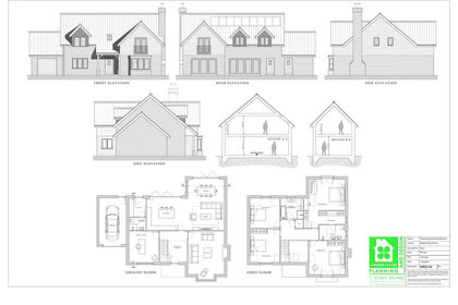
- Price
- Fixed Price£130,000
Plot 2, Skegness Road, Partney, Partney, Lincolnshire PE23 England
Added on 07/02/2026Building Plot
- Price
- Offers in Region of£140,000
Building Plot, The Gables, Hundleby, Hundleby, Lincolnshire PE23 England
Added on 02/04/2026Building Plot Added on 22/06/2026Building Plot
- Price
- £145,000
- Size
- 0.5 acres
Added on 19/03/2026Building Plot Added on 29/01/2026Development Land
 Added on 02/06/2026Building Plot
- Price
- £175,000
- Size
- 0.2 acres
Added on 29/01/2026Building Plot
- Price
- £175,000
- Size
- 0.25 acres
Added on 29/01/2026Building Plot
- Price
- £125,000
- Size
- 0.25 acres
Building Plot at Trianja, Church Lane, Alvingham LN11, Louth, Lincolnshire LN11 England
Added on 29/01/2026Building Plot