Milton Green, Chester, Cheshire
- Land size
- 1.19 acres
Key Features
- Planning approval for 5 open market barn conversions
- Situated on the fringe of Tattenhall village
- All properties will have carport garaging
- South facing domestic gardens
- Approx. 680 sq.m (7317 sq.ft) of proposed accommodation GIA
- Readily accessible site with road frontage
- Site extends to approximately 1.19 acres in total.
Description
Barns with planning approval for 5 open market dwellings, located in a sought-after area on the fringe of the popular village of Tattenhall.
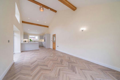
A barn conversion scheme, within a courtyard setting. The scheme allows for four two-storey mews barn conversions and a detached barn conversion. All properties will have generous gardens, garage carports, and ample visitor parking spaces.
Description
• The existing agricultural buildings are of brick construction, under fibre sheet roofing (asbestos). There are two modern steel portal framed buildings which require demolition. The existing brick range extend to approximately 590 sq.m (6348 sq. ft) GIA, with some lean-to and modern attached buildings.
• Approval is for the creation of 5 residential dwellings. The approved plans show two 2-bedroom mews properties, two 3-bedroom mews properties and a detached 3-bedroom house. The estimated total GIA for the five properties is 680 sq. m (7317 sq. ft) GIA, including the “extensions” to the rear of each property.
• Planning exists for the construction of 8 carport garages with additional parking spaces, which can be allocated to the houses as required. In addition there is provision for ample visitors’ spaces.
Planning
• A summary of the planning history, granted by Cheshire West and Chester is as follows:
• 11/03079/FUL & 11/03080/LBC – conversion into 3 dwellings and an office.
• 18/01046/s73 & 18/01309/LBC – variation of plans.
• 19/02798/DIS – discharge of conditions to allow implementation (18/01046/s73)
• 23/00497/LDC – LDC of implementation (18/01046/s73 & 18/01309/LBC)
• 23/00498/FUL & 23/00499/LBC – change of use of office and subdivision of one unit, to provide 5 residential units. (Needs to be implemented by 05/03/27).
• 24/01258/s73 & 24/01457/s19 – approval for an extension to the rear of the detached unit.
• 23/01196/s19 & 23/00915/s73 – application for a larger extension to the rear of unit 5. Planning refused and an appeal submitted and pending.
Situation
Milton Green is within a short distance of the popular village of Tattenhall. The barns enjoy some open countryside views across prime Cheshire countryside.
Tattenhall has an active local community with a good range of local services, including a general store, butchers, hairdressers, public houses, restaurants and doctor's surgery, and Chester has a more comprehensive offering.
The local vicinity offers a range of recreational facilities, including golf at Aldersey Green Golf Club, tennis, squash and cricket at Tattenhall Recreation Club, leisure pursuits at Carden Park Golf Course and Spa and water sports on the river Dee. Local state schooling includes Tattenhall Primary School which is a feeder school for Bishop Heber High School, the latter deemed "outstanding" by Ofsted. Excellent independent schooling is available at Abbeygate College, Saighton and King's and Queen's Schools in Chester. The area is well-placed for commuting to the commercial centres of the North West via the A55 leading to the M53, M56 and M6 networks. Chester station offers direct service to London, Euston within 2 hours.
Information available
• Planning Permissions
• Approved Planning Drawings
• Planning Appeal Drawing
• Site Survey -
Main site and off site for drainage
Barns – Long Barn and Rear barn
• Drainage Design - Bett Associates design
• Asbestos Report and Quote
• Bat Mitigation Licence
• Structural Reports
• Draft Working Drawings for scheme.
Community infrastructure Levy (CIL)
The buyer will be responsible for payment of the CIL charge. The seller has already submitted an Assumption of Liability Notice, but it is yet to be concluded across all 5 units. The seller estimates the CIL charge to be between £6,000 to £8,000 in total. Further information from the selling agents.
Services
Drainage to be provided by way of a bio disc treatment plant, to include a connection for the farmhouse and 5 units. There is mains water and electricity in the vicinity. It is anticipated the properties will be warmed by air source heat pumps. The buyer will be responsible for all service connections and interested parties must make their own enquiries of the relevant statutory authorities, no further information will be provided by the selling agents.
The estimated fastest download speed currently achievable for the property postcode area is around 1000 Mbps] (data taken from checker.ofcom.org.uk on 26/09/2024). Actual service availability at the property or speeds received may be different. We understand that the property is likely to have current mobile coverage (data taken from checker.ofcom.org.uk on 26/09/2024). Please note that actual services available may be different depending on the particular circumstances, precise location and network outages.
Tenure
The property is to be sold freehold with vacant possession.
Local Authority
Cheshire West & Cheshire
Public Rights of Way, Wayleaves and Easements
The property is sold subject to all rights of way, wayleaves and easements whether or not they are defined in this brochure.
Plans, Boundaries and Obligations
The plans within these particulars are based on Ordnance Survey data and provided for reference only. They are believed to be correct but accuracy is not guaranteed. The purchaser shall be deemed to have full knowledge of all boundaries and the extent of ownership. Neither the vendor nor the vendor’s agents will be responsible for dening the boundaries or the ownership thereof.
The buyer will be responsible for the erection of and maintenance of any new boundary fences, where applicable. The buyer will also be responsible for building the courtyard garage block for the farmhouse.
Viewings
Strictly by appointment through Fisher German LLP.
Directions
Postcode – CH3 9DS
what3words ///passenger.stored.cool
From Chester head through Boughton onto the A5115, continuing across the A41 interchange on to the A41.
Continue along the A41 through Waverton and Hatton Heath . On approaching Milton Green after passing Applegates Farm Shop and Café on the right, the entrance to the barns will be seen after a short distance on the left hand side immediately before the former Kia Motors garage.
Map Location
Property details
- Tenure
- Freehold
- Council Tax Band
- TBC
- Date Posted
- 2026-01-29
Market Value Analysis
Compared with 828 Homes with Land listings in North West England (1+ acres).
Utilities & Restrictions
Utilities
- Electricity
- Ask Agent
- Water
- Ask Agent
- Heating
- Ask Agent
- Broadband
- Ask Agent
- Sewerage
- Ask Agent
Rights & Restrictions
- Public Rights of Way
- Ask Agent
- Private Rights of Way
- Ask Agent
- Listed Property
- Ask Agent
- Restrictions
- Ask Agent
Listed status, conservation areas and planning constraints for this location are in the full report.
Property Features
- Accessibility
- Ask Agent
- Parking
- Parking Available
- Garden
- Garden
Beyond the particulars: planning activity, flood history, heritage and ground risks, checked for this exact spot.
Connectivity
Broadband
Fastest speed available at this postcode
1.8 Gbps
Gigabit full fibre · available to 91% of premises
Suitable for
- 4K streaming on every screen
- Full-time home working
- Online gaming & big downloads
Mobile signal
Outdoor predictions; indoor signal depends on building materials.
Ofcom Connected Nations postcode-level predictions. Speeds and signal are modelled, not measured, and vary between addresses and providers.
Signal is the easy part. Planning activity, flood history and protected designations here are in the full report.
Nearest Schools
Primary
- Tattenhall Park Primary School1.1 milesOfsted: Good
- Ages
- 3 to 11
- Pupils
- 199
- Type
- Community school
- Saighton Church of England Primary School & Pre-School2.3 milesNo Ofsted rating
- Ages
- 3 to 11
- Pupils
- 112
- Type
- Voluntary aided school
- Faith
- Church of England
- Clutton Church of England Primary School2.8 milesOfsted: Good
- Ages
- 3 to 11
- Pupils
- 39
- Type
- Academy converter
- Faith
- Church of England
- Waverton Community Primary School3.3 milesOfsted report card · Mar 2026
- Ages
- 5 to 11
- Pupils
- 197
- Type
- Community school
- Huxley CofE Primary School3.5 milesOfsted: Inadequate
- Ages
- 5 to 11
- Pupils
- 63
- Type
- Academy sponsor led
- Faith
- Church of England
Secondary
- Christleton High School4.2 milesOfsted: Good
- Ages
- 11 to 18
- Pupils
- 1,382
- Type
- Academy converter
- The Bishops' Blue Coat Church of England High School4.8 milesOfsted: Good
- Ages
- 11 to 18
- Pupils
- 1,253
- Type
- Academy converter
- Faith
- Church of England
- The Catholic High School, Chester5.1 milesOfsted report card · May 2026
- Ages
- 11 to 18
- Pupils
- 797
- Type
- Academy converter
- Faith
- Roman Catholic
- Queen's Park High School5.3 milesOfsted: Good *
- Ages
- 11 to 18
- Pupils
- 792
- Type
- Academy sponsor led
- Chester International School5.4 milesOfsted: Good
- Ages
- 14 to 19
- Pupils
- 229
- Type
- Studio schools
* Latest graded judgement covers quality of education only; no overall grade was issued under the 2024-25 inspection framework.
Distances are straight-line from the advertised location. Source: the national school registers (DfE, Welsh Government, Scottish Government) and Ofsted.
Schools are just the start: sold prices nearby, planning activity and any flood history are in the full report.
Amenities
Supermarket
GP surgery
Pharmacy
Hospital
Straight-line distances from the advertised location. Sources: NHS records, Geolytix supermarket locations, OS Open Greenspace and the national trails registers.
The area stacks up? Now check the location itself: planning nearby, protected designations and past flooding.
Getting Around
Nearest station
Nearest bus stop
Typical drive times
Straight-line distances from the advertised location; drive times are typical free-flow times over OpenStreetMap road data, so allow more at peak. Public transport locations from DfT NaPTAN.
Easy to reach matters. So do planning activity, flood history and ground risks: all in the full report.
Flood Risk
From Environment Agency flood map open data, checked around the advertised map pin and allowing for the listed acreage where known. This summary comes from LandSale, the advertising platform, not from the listing agent, and is not part of the agent's particulars. Risk can vary across a single holding, so verify anything critical through your own searches before committing.
Rivers and the sea
Surface water
These bandings are the summary. Where this location sits on the flood maps, plus planning activity, heritage and ground risks, is in the full report.
Important notice: Information, maps and tags on this page are drawn from the advertising agent's marketing materials or generated automatically. LandSale has not verified them. Relying on these details is at your own risk, always carry out independent checks before committing to a purchase.
LandSale full disclaimer
Marketing information only - not formal particulars. The details on this website are provided for general guidance and do not constitute an offer or contract. Neither LandSale nor the advertising estate/land agent accepts responsibility for any inaccuracy.
1. Source of information
- Listing content: Core description, asking price, tenure, measurements, photographs and planning history originate from the marketing materials of the advertising estate or land agent. LandSale does not author this content and cannot guarantee its accuracy.
- Automated tags & categorisation: Property type, land-use class, acreage bands and similar labels may be applied by machine-learning models. They are intended as a helpful guide only and may not reflect the property's legal status or permitted use.
- Third-party & enriched data layers: Maps, boundary outlines, planning designations, soil reports, broadband coverage and other environmental or location-based insights are licensed from external suppliers. Such data are supplied “as is", may be incomplete or out of date and are subject to change without notice.
2. Verification required
Prospective purchasers must verify critical matters, including but not limited to planning permission, title boundaries, public rights of way, environmental constraints, acreage, services, access and VAT status, through their own inspections, specialist surveys, legal advisers and the selling agent before relying on the information or entering into any contract.
3. No warranty or liability
LandSale gives no warranty, express or implied, as to the accuracy, completeness or fitness for any particular purpose of the information displayed. LandSale shall not be liable for any loss, damage, cost or expense arising directly or indirectly from any use of or reliance on such information, save where liability may not be excluded by law.
4. Updates & feedback
If you believe any detail on this listing is inaccurate, please let us know. We will investigate and, where appropriate, update the listing or notify the agent.
© LandSale | Version 1.3 - August 2026
Listing agent
Fisher German, Covering Cheshire and North Wales
Covering the North West
View agent profileSimilar properties for sale
- Price
- Offers in Excess of£425,000
Added on 14/03/2026Barn Conversion
- Price
- Offers Over£400,000
Cuckoo's Nest, Cheshire, Poulton and Pulford, Cheshire West and Chester CH4 England
Added on 03/06/2026Barn ConversionLeasehold
- Price
- Offers Over£400,000
Barn Conversion, Pulford, Poulton and Pulford, Cheshire West and Chester CH4 England
Added on 01/06/2026Barn ConversionLeasehold Added on 22/04/2026Barn Conversion
- Price
- Offers in Region of£450,000
- Size
- 0.36 acres
Kidnal, Nr Malpas., Malpas, Cheshire West and Chester SY14 England
Added on 12/08/2026Barn Conversion
- Price
- Guide Price£525,000
Threapwood, Malpas, SY14, Willington Worthenbury, Wrexham SY14 Wales
Added on 01/08/2026Barn Conversion
- Price
- Offers Over£500,000
Wrenbury Road, Chorley Nr. Nantwich, Cholmondeley, Cheshire East CW5 England
Added on 22/05/2026Barn Conversion
- Price
- Guide Price£475,000
Cooks Pit Barns, Woodhey Lane, Faddiley, CW5, Faddiley, Cheshire East CW5 England
Added on 26/08/2026Barn Conversion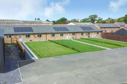 Added on 20/03/2026Barn Conversion
 Added on 22/06/2026Barn Conversion