Carharrack, Redruth - Parcel of land amounting approximately 3.6 acres
- Land size
- 3.6 acres
Key Features
- Freehold parcel of land
- Approximately 3.6 acres
- Land laid mainly to pasture
- Wildlife garden
- Private gated access
- Well defiined boundaries
- Chain free sale
- Rural situation and rare opportunity
Description
Nestling within a gentle sloping valley in a rural location on the outskirts of the village of Carharrack, this is a rare opportunity to acquire a parcel of land amounting to approximately 3.6 acres.
The majority of the land is enclosed pasture and there is also a wildlife garden with a range of saplings and shrubs.
The land is enclosed and access is via a gated entrance off a lane from Wheal Damsel Road, unusually with sales such as this our vendors are not putting any restrictions on its use and subject to any required consent via Cornwall Council, potential buyers will be able to develop the land to their own requirements.
Located off a track from Wheal Damsel Road, the land lies between the village of Carharrack and the ancient site of Gwennap Pit which is at Busveal. Convenient for access to the major towns of Redruth, Falmouth and Truro, there are also the nearby villages of St Day and Lanner. Country walks pass through the area as does the coast to coast footpath linking Portreath to Devoran.
AGENT'S NOTES
Please be advised that this part of Cornwall has extensive historic mining activity and prospective purchasers would be advised to commission a mining report prior to committing to a purchase.
SERVICES
The land does not have any services connected to it although it should be noted that the adjacent property has a Bore Hole water supply and this could well be a suitable means of obtaining water for the site.
DIRECTIONS
From the centre of Carharrack head out of the village towards Falmouth on the B3298 and after passing Chapel Terrace on the right, take the next right and immediately go right again (marked with a tourist sign for Gwennap Pit) into Wheal Damsel Road. The road then bears left and straight ahead is a track with a sign saying Gershoms Ark, from this track down into the valley and at the bottom is the entrance to the field on the right hand side. Your can turn a vehicle at this point if required. If using What3words:- Recorder.Fuels.innovator.
Map Location
Property details
- Tenure
- Freehold
- Council Tax Band
- Ask Agent
- Date Posted
- 2026-01-29
Market Value Analysis
Compared with 101 Bare & Undeveloped Land listings in South West England (1+ acres).
Utilities & Restrictions
Utilities
- Electricity
- Ask Agent
- Water
- Ask Agent
- Heating
- Ask Agent
- Broadband
- Ask Agent
- Sewerage
- Ask Agent
Rights & Restrictions
- Public Rights of Way
- Ask Agent
- Private Rights of Way
- Ask Agent
- Listed Property
- Ask Agent
- Restrictions
- Ask Agent
Property Features
- Accessibility
- Ask Agent
- Parking
- Ask Agent
- Garden
- Garden
Important notice: Information, maps and tags on this page are supplied by the advertising agent or generated automatically. LandSale has not verified them. Relying on these details is at your own risk, always carry out independent checks before committing to a purchase.
LandSale full disclaimer
Marketing information only - not formal particulars. The details on this website are provided for general guidance and do not constitute an offer or contract. Neither LandSale nor the advertising estate/land agent accepts responsibility for any inaccuracy.
1. Source of information
- Agent-supplied content: Core description, asking price, tenure, measurements, photographs and planning history are uploaded by the appointed agent, who remains solely responsible for their accuracy.
- Automated tags & categorisation: Property type, land-use class, acreage bands and similar labels may be applied by machine-learning models. They are intended as a helpful guide only and may not reflect the property's legal status or permitted use.
- Third-party & enriched data layers: Maps, boundary outlines, planning designations, soil reports, broadband coverage and other environmental or location-based insights are licensed from external suppliers. Such data are supplied “as is", may be incomplete or out of date and are subject to change without notice.
2. Verification required
Prospective purchasers must verify critical matters, including but not limited to planning permission, title boundaries, public rights of way, environmental constraints, acreage, services, access and VAT status, through their own inspections, specialist surveys, legal advisers and the selling agent before relying on the information or entering into any contract.
3. No warranty or liability
LandSale gives no warranty, express or implied, as to the accuracy, completeness or fitness for any particular purpose of the information displayed. LandSale shall not be liable for any loss, damage, cost or expense arising directly or indirectly from any use of or reliance on such information, save where liability may not be excluded by law.
4. Updates & feedback
If you believe any detail on this listing is inaccurate, please let us know. We will investigate and, where appropriate, update the listing or notify the agent.
© LandSale | Version 1.2 - January 2026
Listing agent
MAP Estate Agents, Barncoose
Gateway Business Centre, Wilson Way, Barncoose, Illogan Highway, TR15 3RQ
Contact MAP Estate Agents, Barncoose
Gateway Business Centre, Wilson Way, Barncoose, Illogan Highway, TR15 3RQ
View agent profileSimilar properties for sale

- Price
- £175,000
- Size
- 7 acres
Added on 29/01/2026Vacant Land
- Price
- £175,000
- Size
- 7 acres
Added on 29/01/2026Grazing Land
- Price
- Guide Price£95,000
- Size
- 0.91 acres
Added on 12/02/2026Vacant Land
- Price
- Guide Price£95,000
- Size
- 6 acres
Roseland Peninsula - Boswague Portholland, Veryan, Cornwall TR2 5ST England
Added on 29/01/2026Farmland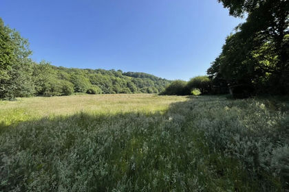
- Price
- Guide Price£150,000
- Size
- 13.82 acres
Added on 17/07/2026Grazing Land
- Price
- Guide Price£80,000
- Size
- 3.29 acres
Botrea, Newbridge, Penzance, Sancreed, Cornwall TR20 8PP England
Added on 16/06/2026Equestrian property
- Price
- Guide Price£130,000
- Size
- 13.54 acres
St. Just, Penzance, TR19, St. Just, Cornwall TR19 7RN England
Added on 28/04/2026Grazing Land
- Price
- £110,000
- Size
- 5.75 acres
Added on 29/01/2026Pasture
- Price
- Guide Price£95,000
- Size
- 5.84 acres
Added on 15/07/2026Vacant Land
- Price
- Guide Price£90,000
- Size
- 3.59 acres
Marine Drive, Widemouth Bay, EX23, Bude-Stratton, Cornwall EX23 0LY England
Added on 15/07/2026Vacant Land