Cordiesmailing, Kings Highway, Largoward, Leven
- Land size
- 6 acres
Description
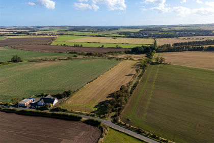
An outstanding opportunity to acquire a residential building plot together with an adjoining paddock, occupying an attractive rural position at Kings Highway, Largoward. Extending in total to approximately six acres, the plot offers the potential to create a bespoke country home surrounded by open Fife countryside, whilst remaining within easy reach of St Andrews and the sought-after East Neuk coastline.
Planning permission in principle has been granted for the erection of a dwellinghouse on the land to the east of Wharenui, presenting an exciting opportunity for a purchaser to create a new home on the site, subject to the necessary detailed consents and planning conditions.
The residential plot itself extends to approximately 429 sq m, as indicated on the submitted block plan, and sits alongside the generous paddock. The combination provides considerable scope to create a distinctive lifestyle property, with space for gardens and outdoor amenity alongside the adjoining grazing ground.
The paddock is a particularly attractive feature, comprising predominantly open grassland bounded by established woodland and planting in parts. Its scale substantially enhances the lifestyle appeal of the opportunity and may suit purchasers with equestrian, smallholding or other rural interests, subject to any necessary consents.
The wider holding enjoys an open rural outlook across the surrounding farmland, while its position close to an established cluster of properties provides a balance between countryside living and accessibility.
EPC Rating - N/A
Council Band - N/A
Tenure - Freehold
Summary
• Residential development plot with adjoining paddock
• Approximately six acres in total
• Residential plot indicated at approximately 429 sq m
• Planning permission in principle for erection of a dwellinghouse - Planning Reference: 25/01684/
• Scope to create a bespoke detached country home, subject to detailed consents
• Extensive adjoining grassland
• Established rural setting
• Convenient for St Andrews and the East Neuk coastline
• Mains water, electricity and drainage are located nearby to the site
Location
Kings Highway enjoys an attractive rural setting near Largoward, surrounded by the rolling agricultural landscape for which this part of North East Fife is renowned. The position offers a wonderful opportunity to enjoy the space and tranquillity of countryside living whilst remaining well placed for access to St Andrews, Cupar and the East Neuk.
Largoward is a well-established rural village positioned between St Andrews and the Fife coast. The surrounding area is characterised by open farmland, quiet country roads and scattered woodland, providing excellent opportunities for walking, cycling and enjoying the outdoors.
The historic town of St Andrews lies to the north-east and provides an outstanding selection of independent shops, restaurants, cafés and cultural amenities, together with the internationally renowned University of St Andrews and its world-famous golf courses.
To the south, the East Neuk coastline is readily accessible, with the sought-after villages of Elie, St Monans, Pittenweem, Anstruther and Crail offering picturesque harbours, beaches, restaurants and access to the Fife Coastal Path.
Cupar and Leven provide a wider range of everyday amenities and transport links, making the location particularly appealing to purchasers seeking a country lifestyle without feeling isolated from the principal towns and coastal communities of North East Fife.
Overall, the combination of planning permission in principle, substantial acreage and an accessible rural position makes this a particularly appealing opportunity to create an individual country property in a highly desirable part of Fife.
General Remarks & Information
Services:
Mains water, electricity and drainage are located nearby to the site
Offers:
Offers should be submitted in Scottish Legal Form to the selling agents Rettie & Co. A closing date by which offers must be submitted may be fixed later. Please note that interested parties are advised to register their interest with the selling agents in order that they may be advised should a closing date be set. The seller reserves the right to accept any offer at any time.
Postcode:
KY9 1JA
Tenure:
Freehold
Particulars Prepared:
6th November 20026
Internet Website
This property and other properties offered by Rettie & Co. & Rettie LLP's.
Servitude Rights, Burdens & Wayleaves
The property is sold subject to and with the benefit of all servitude rights, burdens, reservations and wayleaves including rights of access and rights of way, whether public or private, light, support, drainage, water and wayleaves for masts, pylons, stays, cable, drains and water, gas and other pipes whether contained in the title deeds or informally constituted and whether or not referred to above.
Important Notice
Rettie, their clients and any joint agents give notice that:
They are not authorised to make or give any representations or warranties in relation to the property either in writing or by word of mouth. Any information given is entirely without
responsibility on the part of the agents or the sellers. These particulars do not form part of any offer or contract and must not be relied upon as statements or representations of fact.
All Rettie floorplans are drawn to RICS standard. The text, photographs and plans are for guidance only and are not necessarily comprehensive and it should not be assumed that the property remains as photographed. Any error, omission or mis-statement shall not annul the sale or entitle any party to compensation or recourse to action at law. It should not be assumed that the property has all necessary planning, building regulation or other consents, including for its current use. Rettie & Co. & Rettie LLP’s have not tested any services, equipment or facilities. Purchasers must satisfy themselves by inspection or otherwise and ought to seek their own professional advice.
All descriptions or references to condition are given in good faith only. Whilst every endeavour is made to ensure accuracy, please check with us on any points of especial importance to you, especially if intending to travel some distance. No responsibility can be accepted for expenses incurred in inspecting properties which have been sold or withdrawn.
Proof and source of Funds/Anti Money Laundering
All sellers and buyers will be required to complete Anti-Money Laundering (AML) checks via our specialist third-party provider, Coadjute, who conduct these checks on our behalf. These checks will include identity verification, proof of address, and proof of funds if applicable. For further information on how your personal data is processed, please refer to Rettie's Privacy Policy and Coadjute's Data Security Statement.
Misrepresentations
The property is sold with all faults and defects, whether of condition or otherwise and neither the seller nor Rettie & Co. or Rettie LLP’s, the selling agent, are responsible for such faults and defects, nor for any statement contained in the particulars of the property prepared by the said agent.
The Purchaser(s) shall be deemed to acknowledge that they have not entered into contract in reliance on the said statements, that they are satisfied themselves as to the content of each of the said statements by inspection or otherwise and that no warranty or representation has been made by the seller or the said agents in relation to or in connection with the property.
Any error, omission or misstatement in any of the said statements shall not entitle the purchaser(s) to rescind or to be discharged from this contract, nor entitle either party to compensation or damages nor in any circumstances to give either party any cause for action.
Map Location
Property details
- Tenure
- Freehold
- Council Tax Band
- TBC
- Date Posted
- 2026-11-10
Market Value Analysis
Compared with 12 Building Plots listings in Scotland (5+ acres).
Utilities & Restrictions
Utilities
- Electricity
- Ask Agent
- Water
- Ask Agent
- Heating
- Ask Agent
- Broadband
- Ask Agent
- Sewerage
- Ask Agent
Rights & Restrictions
- Public Rights of Way
- Ask Agent
- Private Rights of Way
- Ask Agent
- Listed Property
- Ask Agent
- Restrictions
- Ask Agent
Listed status, conservation areas and planning constraints for this location are in the full report.
Property Features
- Accessibility
- Ask Agent
- Parking
- Ask Agent
- Garden
- Garden
Beyond the particulars: planning activity, flood history, heritage and ground risks, checked for this exact spot.
Connectivity
Broadband
Fastest speed available at this postcode
1.8 Gbps
Gigabit full fibre · available to 88% of premises
Suitable for
- 4K streaming on every screen
- Full-time home working
- Online gaming & big downloads
Mobile signal
Predicted 4G and 5G signal; indoor signal depends on building materials.
Ofcom Connected Nations postcode-level predictions. Speeds and signal are modelled, not measured, and vary between addresses and providers.
Signal is the easy part. Planning activity, flood history and protected designations here are in the full report.
Nearest Schools
Primary
- Largoward Primary School301 metres
- Pupils
- 17
- Type
- Non-denominational
- Colinsburgh Primary School2.8 miles
- Pupils
- 38
- Type
- Non-denominational
- Kirkton of Largo Primary School3.8 miles
- Type
- Non-denominational
- Lundin Mill Primary School4.6 miles
- Pupils
- 127
- Type
- Non-denominational
- Ceres Primary School4.7 miles
- Pupils
- 111
- Type
- Non-denominational
Secondary
- Madras College5.9 miles
- Pupils
- 1,412
- Type
- Non-denominational
- Waid Academy6.5 miles
- Pupils
- 681
- Type
- Non-denominational
- Bell Baxter High School7.6 miles
- Pupils
- 1,510
- Type
- Non-denominational
- Levenmouth Academy8.6 miles
- Pupils
- 1,755
- Type
- Non-denominational
- Auchmuty High School12 miles
- Pupils
- 1,302
- Type
- Non-denominational
Distances are straight-line from the advertised location. Source: the national school registers (DfE, Welsh Government, Scottish Government) and Ofsted.
Schools are just the start: planning activity, heritage and any flood history here are in the full report.
Amenities
Supermarket
GP surgery
Pharmacy
Green space
Walking trail
Straight-line distances from the advertised location. Sources: NHS records, Geolytix supermarket locations, OS Open Greenspace and the national trails registers.
The area stacks up? Now check the location itself: planning nearby, protected designations and past flooding.
Getting Around
Nearest station
Nearest bus stop
Typical drive times
Straight-line distances from the advertised location; drive times are typical free-flow times over OpenStreetMap road data, so allow more at peak. Public transport locations from DfT NaPTAN.
Easy to reach matters. So do planning activity, flood history and ground risks: all in the full report.
Flood Risk
SEPA open data, checked around the advertised map pin for the listed acreage. The map pin for this listing is approximate, so these readings describe the surrounding area. Provided by LandSale, not the listing agent, and not part of the agent's particulars. Risk varies across a holding, so verify before committing.
Rivers and the sea
Surface water
Not at the pin: mapped about 30 metres away.
These bandings are the summary. Where this location sits on the flood maps, plus planning activity, heritage and ground risks, is in the full report.
Important notice: Information, maps and tags on this page are drawn from the advertising agent's marketing materials or generated automatically. LandSale has not verified them. Relying on these details is at your own risk, always carry out independent checks before committing to a purchase.
LandSale full disclaimer
Marketing information only - not formal particulars. The details on this website are provided for general guidance and do not constitute an offer or contract. Neither LandSale nor the advertising estate/land agent accepts responsibility for any inaccuracy.
1. Source of information
- Listing content: Core description, asking price, tenure, measurements, photographs and planning history originate from the marketing materials of the advertising estate or land agent. LandSale does not author this content and cannot guarantee its accuracy.
- Automated tags & categorisation: Property type, land-use class, acreage bands and similar labels may be applied by machine-learning models. They are intended as a helpful guide only and may not reflect the property's legal status or permitted use.
- Third-party & enriched data layers: Maps, boundary outlines, planning designations, soil reports, broadband coverage and other environmental or location-based insights are licensed from external suppliers. Such data are supplied “as is", may be incomplete or out of date and are subject to change without notice.
2. Verification required
Prospective purchasers must verify critical matters, including but not limited to planning permission, title boundaries, public rights of way, environmental constraints, acreage, services, access and VAT status, through their own inspections, specialist surveys, legal advisers and the selling agent before relying on the information or entering into any contract.
3. No warranty or liability
LandSale gives no warranty, express or implied, as to the accuracy, completeness or fitness for any particular purpose of the information displayed. LandSale shall not be liable for any loss, damage, cost or expense arising directly or indirectly from any use of or reliance on such information, save where liability may not be excluded by law.
4. Updates & feedback
If you believe any detail on this listing is inaccurate, please let us know. We will investigate and, where appropriate, update the listing or notify the agent.
© LandSale | Version 1.3 - August 2026
Nearby properties for sale
- Price
- Offers Over£30,000
- Size
- 3.85 acres
Glasterlaw Glebe, Arbroath, DD11, Arbroath, Angus DD11 Scotland
Added on 05/11/2026Cheap Land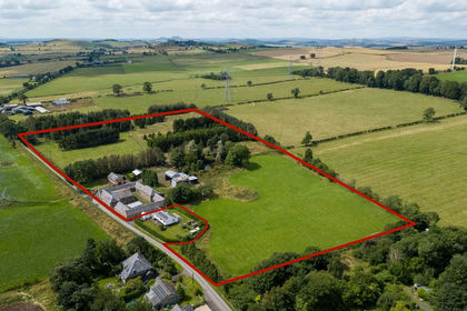
- Price
- Guide Price£425,000
- Size
- 13 acres
Wester Howlaws Farm, Wester Howlaws, Greenlaw, TD10, Duns, Scottish Borders TD10 Scotland
Added on 04/04/2026Smallholding
- Price
- Offers in Excess of£80,000
- Size
- 10.38 acres
Added on 11/09/2026Grazing Land
- Price
- Offers Over£499,000
- Size
- 2.3 acres
Added on 29/01/2026Equestrian property
- Price
- Offers Over£390,000
- Size
- 4 acres
Clatt, Huntly, AB54, Gordon and Buchan, Aberdeenshire AB54 Scotland
Added on 29/09/2026Smallholding
- Price
- Offers Over£425,000
- Size
- 36.2 acres
Longframlington, Morpeth, Northumberland, NE65, Longframlington, Northumberland NE65 England
Added on 09/09/2026Smallholding
- Price
- Offers Over£370,000
- Size
- 2.8 acres
East Linnbridgeford, Waterbeck, Lockerbie, DG11, Lockerbie, Dumfries and Galloway DG11 Scotland
Added on 30/10/2026Cottage
- Price
- Offers Over£325,000
- Size
- 2 acres
Glenlivet, Ballindalloch, Moray West, Nairn and Strathspey, Moray AB37 Scotland
Added on 08/10/2026House with Land
- Price
- Offers in Excess of£260,000
- Size
- 1 acres
Logierieve, Ellon, AB41, Gordon and Buchan, Aberdeenshire AB41 Scotland
Added on 14/11/2026Smallholding
- Price
- Offers Over£440,000
- Size
- 9 acres
Ythanwells, Huntly, AB54, Gordon and Buchan, Aberdeenshire AB54 Scotland
Added on 08/08/2026Smallholding