Treswithian Downs, Camborne
- Land size
- 31.43 acres
- Bedrooms
- 2
- Bathrooms
- 1
Key Features
- 31 acre small holding
- Ring-fenced farmstead
- Detached character dwelling
- Range of traditional and modern buildings
- Largely level pasture land
- Sold with no onward chain
Description
For sale for the first time in over 100 years - a ring-fenced small holding extending to over 30 acres and with largely level land together with a character dwelling and a range of traditional and modern buildings. Accessible location near the north Cornish coast. Offered for sale with no onward chain.
The Property
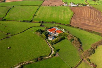
In the same family ownership since 1912 and completely unspoilt is this wonderful ring-fenced small holding extending to 31.43 acres or thereabouts. Comprising a detached character property set amongst a range of traditional and modern farm buildings, many with potential for a number of uses or for conversion (subject to consent), together with nine field enclosures New Downs Farm offers an opportunity to create a lifestyle property seldom available in the market and must be viewed to be fully appreciated.
The Dwelling
At the heart of the farmstead is a double fronted period house which, whilst in need of some upgrading and improvement, offers a comfortable family home with scope for enlargement (subject to consent) full of charm, character features and incredibly high ceilings within the original part. Formerly a three bedroom dwelling the accommodation currently comprises; entrance hall with tessellated tiled floor and large understairs cupboard, sitting room with open fire, dining room with woodburning stove, office, rear lobby, kitchen, utility, w.c. and rear porch to the ground floor with two double bedroooms - the principal bedroom being particularly large - and a family bathroom to the first floor. With some reconfiguration of the first floor accommodation (subject to consent) the property could easily be arranged to offer three bedrooms again.
To the rear of the dwelling is a lawned garden leading to a former vegetable garden with polytunnel frame and greenhouse, and a Mediterranean garden complete with fig and olive trees and a pergola adorned with a mature wisteria, whilst to the front is an orchard garden.
Farm Buildings
Forming a courtyard arrangement behind the dwelling are a number of traditional stone and red-brick built barns including a two storey stone barn, a single storey stable block complete with cobbled yard, a workshop, store and a double car port. Some of these buildings are considered to have potential for conversion into additional dwelling(s) or ancillary accommodation or perhaps with potential for commercial use (all subject to consent).
At the entrance to the farmstead are two Dutch barns suited for the storage of machinery, hay, straw etc and within one of the field enclosures is a large timber field shelter.
Land & Grounds
The land is, in its majority, almost totally level and is set across nine field enclosures, most with water connected and all with good natural shelter provided by hedge and tree lined boundaries. Each enclosure is in permanent pasture and is well suited to livestock grazing. The land is classified as Grade III on the Land Classification Map.
Alongside the Dutch barns is a large yard area with hard standing and this continues around to the property and the traditional barns, providing ample parking and turning space for vehicles, trailers etc.
The grounds at New Downs Farm extend to approximately 31.43 acres in all.
Property Information
EPC E Council Tax Band C
Services
Mains water and electricity. Private drainage. Oil fired central heating.
None of these services have been tested and therefore no guarantees can be given. Interested parties are advised to make their own enquiries to the relevant service providers.
Wayleaves, Easements & Rights of Way
The sale will be subject to and with the benefit of all wayleaves, easements and rights of way as may exist. A public footpath crosses two of the field enclosures (as indicated by a dashed line on the land plan) and the property is accessed via a long track (also a public footpath) in third party ownership over which this property has the benefit of a vehicular right of way.
Particulars & Plan
Whilst every care is taken in the preparation of these particulars, their accuracy is not guaranteed and they do not constitute any part of an offer or contract. Any intending purchaser/s must satisfy themselves by inspection or otherwise as to the correctness of these particulars.
Location
Treswithian Downs is a sought after semi-rural location being so easily accessible from the A30. Nearby Kehelland offers a primary school whilst Camborne town offers a whole range of amenities including primary and secondary schooling, supermarkets, leisure and retail facilities as well as a mainline railway link to London (Paddington). The stunning north coast beaches at Hayle, Gwithian and Portreath are all within 5 and 6 miles respectively.
Viewing & Directions
Strictly by appointment with the sole selling agent Lodge & Thomas.
Tel: .
Email:
Directions
Proceeding along the A30 westbound exit at Camborne (West) A3047 and turn left at the junction, heading towards the roundabout. Exit right at the roundabout (turning back on yourself) and proceed over the flyover before turning left signposted Crematorium. Follow this road as it bears sharply left and the entrance lane leading to New Downs Farm will be found on the left hand side after almost a quarter of a mile.
What3words///bookcases.modern.gratitude
(head of entrance lane)
Map Location
Property details
- Tenure
- Freehold
- Council Tax Band
- C
- Date Posted
- 2026-11-03
Market Value Analysis
Compared with 68 Farms & Smallholdings listings in South West England (25+ acres).
Energy Performance Certificate
Energy Efficiency Rating
Based on UK Energy Performance Certificate standards (EU Directive 2002/91/EC)
Running costs are one side. Planning activity, flood history and ground risks for this location are in the full report.
Utilities & Restrictions
Utilities
- Electricity
- Mains
- Water
- Mains
- Heating
- Oil Heating
- Broadband
- Ask Agent
- Sewerage
- Septic Tank / Private
Rights & Restrictions
- Public Rights of Way
- Ask Agent
- Private Rights of Way
- Ask Agent
- Listed Property
- Ask Agent
- Restrictions
- Ask Agent
Listed status, conservation areas and planning constraints for this location are in the full report.
Property Features
- Accessibility
- Ask Agent
- Parking
- Covered Parking
- Garden
- Garden
Beyond the particulars: planning activity, flood history, heritage and ground risks, checked for this exact spot.
Connectivity
Broadband
Fastest speed available at this postcode
1.8 Gbps
Gigabit full fibre · available to 8% of premises
Suitable for
- 4K streaming on every screen
- Full-time home working
- Online gaming & big downloads
Fixed wireless access may also be an option here.
Mobile signal
Predicted 4G and 5G signal; indoor signal depends on building materials.
Ofcom Connected Nations postcode-level predictions. Speeds and signal are modelled, not measured, and vary between addresses and providers.
Signal is the easy part. Planning activity, flood history and protected designations here are in the full report.
Nearest Schools
Primary
- Kehelland Village School588 metresOfsted: Good
- Ages
- 4 to 11
- Pupils
- 64
- Type
- Academy converter
- Weeth Community Primary School0.7 milesOfsted: Good
- Ages
- 4 to 11
- Pupils
- 182
- Type
- Academy converter
- St Meriadoc CofE Junior Academy0.7 milesNo Ofsted rating
- Ages
- 7 to 11
- Pupils
- 216
- Type
- Academy converter
- Faith
- Church of England
- St Meriadoc CofE Infant Academy0.9 milesNo Ofsted rating
- Ages
- 2 to 7
- Pupils
- 173
- Type
- Academy converter
- Faith
- Church of England
- Trevithick Learning Academy1.3 milesOfsted: Good
- Ages
- 2 to 11
- Pupils
- 520
- Type
- Academy converter
Secondary
- Camborne Science and International Academy886 metresOfsted: Good
- Ages
- 11 to 18
- Pupils
- 1,751
- Type
- Academy converter
- Pool Academy2.3 milesOfsted report card · Mar 2026
- Ages
- 11 to 16
- Pupils
- 714
- Type
- Academy converter
- Redruth School3.8 milesNo Ofsted rating
- Ages
- 11 to 16
- Pupils
- 1,433
- Type
- Foundation school
- Hayle Academy4.6 milesOfsted report card · Jun 2026
- Ages
- 11 to 16
- Pupils
- 623
- Type
- Academy converter
- St Ives School7.2 milesNo Ofsted rating
- Ages
- 11 to 16
- Pupils
- 580
- Type
- Academy sponsor led
Distances are straight-line from the advertised location. Source: the national school registers (DfE, Welsh Government, Scottish Government) and Ofsted.
Schools are just the start: sold prices nearby, planning activity and any flood history are in the full report.
Amenities
Supermarket
GP surgery
Pharmacy
Hospital
Green space
Straight-line distances from the advertised location. Sources: NHS records, Geolytix supermarket locations, OS Open Greenspace and the national trails registers.
The area stacks up? Now check the location itself: planning nearby, protected designations and past flooding.
Getting Around
Nearest station
Nearest bus stop
Typical drive times
Straight-line distances from the advertised location; drive times are typical free-flow times over OpenStreetMap road data, so allow more at peak. Public transport locations from DfT NaPTAN.
Easy to reach matters. So do planning activity, flood history and ground risks: all in the full report.
Flood Risk
Environment Agency open data, checked around the advertised map pin for the listed acreage. Long-term risk counts flood defences; the planning map's flood zones do not. Provided by LandSale, not the listing agent, and not part of the agent's particulars. Risk varies across a holding, so verify before committing.
Rivers and the sea
Planning map: Flood Zone 1.
Surface water
Not at the pin: mapped about 30 metres away.
These bandings are the summary. Where this location sits on the flood maps, plus planning activity, heritage and ground risks, is in the full report.
Important notice: Information, maps and tags on this page are drawn from the advertising agent's marketing materials or generated automatically. LandSale has not verified them. Relying on these details is at your own risk, always carry out independent checks before committing to a purchase.
LandSale full disclaimer
Marketing information only - not formal particulars. The details on this website are provided for general guidance and do not constitute an offer or contract. Neither LandSale nor the advertising estate/land agent accepts responsibility for any inaccuracy.
1. Source of information
- Listing content: Core description, asking price, tenure, measurements, photographs and planning history originate from the marketing materials of the advertising estate or land agent. LandSale does not author this content and cannot guarantee its accuracy.
- Automated tags & categorisation: Property type, land-use class, acreage bands and similar labels may be applied by machine-learning models. They are intended as a helpful guide only and may not reflect the property's legal status or permitted use.
- Third-party & enriched data layers: Maps, boundary outlines, planning designations, soil reports, broadband coverage and other environmental or location-based insights are licensed from external suppliers. Such data are supplied “as is", may be incomplete or out of date and are subject to change without notice.
2. Verification required
Prospective purchasers must verify critical matters, including but not limited to planning permission, title boundaries, public rights of way, environmental constraints, acreage, services, access and VAT status, through their own inspections, specialist surveys, legal advisers and the selling agent before relying on the information or entering into any contract.
3. No warranty or liability
LandSale gives no warranty, express or implied, as to the accuracy, completeness or fitness for any particular purpose of the information displayed. LandSale shall not be liable for any loss, damage, cost or expense arising directly or indirectly from any use of or reliance on such information, save where liability may not be excluded by law.
4. Updates & feedback
If you believe any detail on this listing is inaccurate, please let us know. We will investigate and, where appropriate, update the listing or notify the agent.
© LandSale | Version 1.3 - August 2026
Similar properties for sale
- Price
- Guide Price£795,000
- Size
- 10.5 acres
Added on 12/10/2026Smallholding
- Price
- £620,000
- Size
- 4.9 acres
Tregolls, Stithians, Truro, Cornwall, TR3, Stithians, Cornwall TR3 England
Added on 17/10/2026Smallholding
- Price
- Guide Price£770,000
- Size
- 19.08 acres
Tregolls, Stithians, Truro, Cornwall, TR3, Stithians, Cornwall TR3 England
Added on 17/10/2026Smallholding
- Price
- Guide Price£675,000
- Size
- 7.74 acres
Added on 28/10/2026Smallholding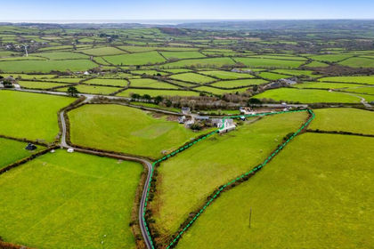
- Price
- Guide Price£745,000
- Size
- 4 acres
Stunning Home with Land & Consent for Additional Dwelling, Wendron, Cornwall TR13 England
Added on 21/08/2026House with Land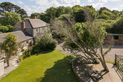
- Price
- £550,000
- Size
- 2 acres
Stunning Barn Conversion with Land & Stables in Nancledra, Towednack, Cornwall TR20 England
Added on 29/01/2026Smallholding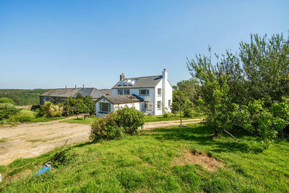
- Price
- Guide Price£775,000
- Size
- 5.73 acres
Added on 09/06/2026Farmhouse
- Price
- Guide Price£700,000
- Size
- 10 acres
Foxhole, St. Austell, St. Stephen-in-Brannel, Cornwall PL26 England
Added on 23/10/2026Smallholding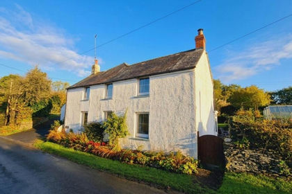
- Price
- £625,000
- Size
- 4.58 acres
Added on 07/10/2026House with Land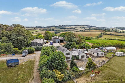
- Price
- Guide Price£925,000
- Size
- 36.51 acres
Trewidland, Liskeard, PL14, St. Keyne and Trewidland, Cornwall PL14 England
Added on 19/05/2026Smallholding