
Land At Morchard Bishop, Crediton, EX17
- Land size
- 29.34 acres
Key Features
- Productive agricultural land
- Convenient location close to the village
- Track access
- Pasture used for grazing and fodder production
- Superb views
- Agricultural, equestrian, conservation and amenity potential.
- In all about 29.34 Acres.
Description
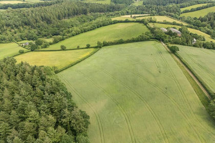
An attractive and versatile block of productive agricultural land enjoying a convenient position close to the village with superb views and potential for a variety of agricultural, equestrian or amenity uses. In all about 29.34 Acres.
The sale of this land represents an excellent opportunity to acquire a well-situated block of versatile agricultural land occupying a convenient and readily accessible rural position close to Morchard Bishop. Contained within hedged and fenced boundaries the land is divided into a number of manageable enclosures, with the benefit of right of way track access leading from the road which runs from Morchard Bishop to the A377 at Morchard Road. The land is primarily gently sloping enjoying a southerly aspect with mains trough watering available to all fields. Whilst we understand that some fields have previously been utilised for arable cropping, the land is currently sown to a combination of productive grass/herbal leys with some longer term pasture.
Whilst the land may be well suited to arable cropping, fodder production and livestock grazing, its convenient location, superb views towards Dartmoor and aesthetic appeal may also make it suitable for a variety of other agricultural, equestrian, conservation or amenity uses, subject to obtaining any necessary consents. In total, the land extends to about 29.34 acres, as shown shaded red on the attached identification plan.
Tenure
The land is of freehold tenure with vacant possession available upon completion of the sale.
Services
The land benefits from mains trough watering. The land will be sold without any other mains services of any kind and prospective purchasers should make their own enquires as to the availability of mains electricity and any other services.
Agri-Environment Schemes & Designations
We understand that the land is currently entered into a Higher Tier Countryside Stewardship agreement which is due to expire on the 1st January 2027.
Sporting & Mineral Rights
The sporting and mineral rights across the land, insofar as they are owned, will be included in the freehold sale.
Rights of Way, Easements, Etc.
It is understood that the land benefits from a right of way over the track leading from the council road.
A public footpath crosses the land.
The land, as far as required by the Vendors, will be conveyed, subject to all other public or private rights of way, easements, and wayleaves of telegraph and telephone poles, stays and wires, electric pylons, poles and cables, water and gas pipes at present erected on and passing over or under the property and subject to the agreements affecting the same (if any).
Farm Properties Health & Safety Notice
All persons wishing to view the land do so entirely at their own risk. Neither the Vendors or their Agents will be held liable for any damage or injury that may occur when interested parties are visiting the property. Agricultural land is a potentially hazardous environment and for prospective purchasers own personal safety, please be vigilant when viewing, particularly in fields containing horses or stock. All persons viewing the property are asked to observe the country code and close all gates.
The land enjoys a convenient position a short distance to the south of the popular village of Morchard Bishop, enjoying far reaching views over the surrounding unspoilt Devon countryside towards Dartmoor. Despite its rural position the land is well situated for easy access to the surrounding districts and main routes of communication. The village of Morchard Bishop provides a thriving local community with a range of local services including a post office/stores, primary school, doctors surgery, parish church and popular public house, The London Inn. The nearby A377 Barnstaple to Exeter road provides easy access to the larger centres of Crediton and Exeter to the south east. Tiverton lies approximately 15 miles to the east with access to the M5 motorway available at Junction 27. Mainline rail services are available at Exeter and Tiverton Parkway, with international airports at Exeter and Bristol.
The land is surrounded by picturesque Devon countryside providing a wealth of recreational activities including walking, horse riding, cycling, fishing, hunting, shooting and golf courses at Crediton, Tiverton and Barnstaple. To the north and south the Exmoor and Dartmoor National Parks respectively offer beautiful moorland scenery with many foot and bridle paths.
Directions
Travelling south easterly towards Crediton on the A377 at Morchard Road turn left beside The Devonshire Dumpling public house signed for Morchard Bishop. Follow this road for approximately 2.3 miles and as you start to enter the village the entrance to the right of way access track to the land will be found on the left hand side, denoted by the agents ‘For Sale’ board.
What3Words - For the exact location of the entrance to the access track download the App and enter:- frogs.stub.messaging
Please Note:- You are strongly advised to follow the directions above rather than relying on satellite navigation.
Map Location
Property details
- Tenure
- Freehold
- Council Tax Band
- Ask Agent
- Date Posted
- 2026-11-02
Market Value Analysis
Compared with 93 Farmland & Pasture listings in South West England (25+ acres).
Utilities & Restrictions
Utilities
- Electricity
- Ask Agent
- Water
- Ask Agent
- Heating
- Ask Agent
- Broadband
- Ask Agent
- Sewerage
- Ask Agent
Rights & Restrictions
- Public Rights of Way
- Ask Agent
- Private Rights of Way
- Ask Agent
- Listed Property
- Ask Agent
- Restrictions
- Ask Agent
Listed status, conservation areas and planning constraints for this location are in the full report.
Property Features
- Accessibility
- Ask Agent
- Parking
- Ask Agent
- Garden
- Ask Agent
Beyond the particulars: planning activity, flood history, heritage and ground risks, checked for this exact spot.
Connectivity
Broadband
Fastest speed available at this postcode
80 Mbps
Superfast
Suitable for
- HD streaming
- Video calls
- Web & social
Fixed wireless access may also be an option here.
Mobile signal
Predicted 4G and 5G signal; indoor signal depends on building materials.
Ofcom Connected Nations postcode-level predictions. Speeds and signal are modelled, not measured, and vary between addresses and providers.
Signal is the easy part. Planning activity, flood history and protected designations here are in the full report.
Nearest Schools
Primary
- Morchard Bishop Church of England Primary School561 metresNo Ofsted rating
- Ages
- 2 to 11
- Pupils
- 101
- Type
- Academy converter
- Faith
- Church of England
- St Thomas of Canterbury CofE Primary School2.3 milesOfsted report card · Jun 2026
- Ages
- 2 to 11
- Pupils
- 51
- Type
- Academy converter
- Faith
- Anglican/Church of England
- Copplestone Primary School2.8 milesOfsted: Good
- Ages
- 4 to 11
- Pupils
- 138
- Type
- Foundation school
- East Worlington Primary School4 milesNo Ofsted rating
- Ages
- 0 to 11
- Pupils
- 75
- Type
- Academy converter
- Bow Community Primary School4.6 milesOfsted: Good *
- Ages
- 4 to 11
- Pupils
- 133
- Type
- Community school
Secondary
- Queen Elizabeth's5.6 milesOfsted report card · May 2026
- Ages
- 11 to 18
- Pupils
- 1,096
- Type
- Academy converter
- Chulmleigh Community College6.9 milesNo Ofsted rating
- Ages
- 11 to 16
- Pupils
- 735
- Type
- Academy converter
- South Molton Community College12 milesOfsted: Good *
- Ages
- 11 to 16
- Pupils
- 656
- Type
- Foundation school
- Thomas Hall School12 milesOfsted: Requires improvement
- Ages
- 4 to 16
- Pupils
- 438
- Type
- Free schools
- Tiverton High School12 milesOfsted: Inadequate *
- Ages
- 11 to 16
- Type
- Academy sponsor led
* Latest graded judgement covers quality of education only; no overall grade was issued under the 2024-25 inspection framework.
Distances are straight-line from the advertised location. Source: the national school registers (DfE, Welsh Government, Scottish Government) and Ofsted.
Schools are just the start: sold prices nearby, planning activity and any flood history are in the full report.
Amenities
Supermarket
GP surgery
Pharmacy
Hospital
Green space
Straight-line distances from the advertised location. Sources: NHS records, Geolytix supermarket locations, OS Open Greenspace and the national trails registers.
The area stacks up? Now check the location itself: planning nearby, protected designations and past flooding.
Getting Around
Nearest station
Nearest bus stop
Typical drive times
Straight-line distances from the advertised location; drive times are typical free-flow times over OpenStreetMap road data, so allow more at peak. Public transport locations from DfT NaPTAN.
Easy to reach matters. So do planning activity, flood history and ground risks: all in the full report.
Flood Risk
Environment Agency open data, checked around the advertised map pin for the listed acreage. Long-term risk counts flood defences; the planning map's flood zones do not. Provided by LandSale, not the listing agent, and not part of the agent's particulars. Risk varies across a holding, so verify before committing.
Rivers and the sea
Planning map: Flood Zone 1.
Surface water
Not at the pin: mapped about 30 metres away.
These bandings are the summary. Where this location sits on the flood maps, plus planning activity, heritage and ground risks, is in the full report.
Important notice: Information, maps and tags on this page are drawn from the advertising agent's marketing materials or generated automatically. LandSale has not verified them. Relying on these details is at your own risk, always carry out independent checks before committing to a purchase.
LandSale full disclaimer
Marketing information only - not formal particulars. The details on this website are provided for general guidance and do not constitute an offer or contract. Neither LandSale nor the advertising estate/land agent accepts responsibility for any inaccuracy.
1. Source of information
- Listing content: Core description, asking price, tenure, measurements, photographs and planning history originate from the marketing materials of the advertising estate or land agent. LandSale does not author this content and cannot guarantee its accuracy.
- Automated tags & categorisation: Property type, land-use class, acreage bands and similar labels may be applied by machine-learning models. They are intended as a helpful guide only and may not reflect the property's legal status or permitted use.
- Third-party & enriched data layers: Maps, boundary outlines, planning designations, soil reports, broadband coverage and other environmental or location-based insights are licensed from external suppliers. Such data are supplied “as is", may be incomplete or out of date and are subject to change without notice.
2. Verification required
Prospective purchasers must verify critical matters, including but not limited to planning permission, title boundaries, public rights of way, environmental constraints, acreage, services, access and VAT status, through their own inspections, specialist surveys, legal advisers and the selling agent before relying on the information or entering into any contract.
3. No warranty or liability
LandSale gives no warranty, express or implied, as to the accuracy, completeness or fitness for any particular purpose of the information displayed. LandSale shall not be liable for any loss, damage, cost or expense arising directly or indirectly from any use of or reliance on such information, save where liability may not be excluded by law.
4. Updates & feedback
If you believe any detail on this listing is inaccurate, please let us know. We will investigate and, where appropriate, update the listing or notify the agent.
© LandSale | Version 1.3 - August 2026
Contact Greenslade Taylor Hunt, South Molton
23 Broad Street, South Molton, EX36 3AQ
View agent profileSimilar properties for sale
- Price
- Guide Price£280,000
- Size
- 30.47 acres
Added on 03/07/2026Vacant Land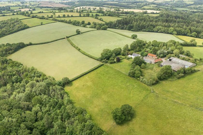
- Price
- Guide Price£295,000
- Size
- 33.03 acres
Added on 03/07/2026Farm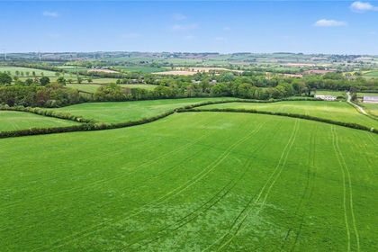
- Price
- Guide Price£265,000
- Size
- 33.09 acres
Station Farm - Lot 3, 33.09 Acres - Bow, Crediton, EX17, Crediton, Devon EX17 England
Added on 05/06/2026Agricultural Land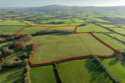
- Price
- Guide Price£295,000
- Size
- 34.64 acres
Sampford Courtenay, Okehampton, EX20, Sampford Courtenay, Devon EX20 England
Added on 28/04/2026Farmland
- Price
- £312,000
- Size
- 35.37 acres
Lot 1: 35.37 of Land at Bolsters Wood, Exeter, Exeter, Devon EX4 England
Added on 29/01/2026Vacant Land
- Price
- Guide Price£275,000
- Size
- 25.17 acres
Land To The South Of Westcott, Cullompton, Devon, EX15, , Devon EX15 England
Added on 16/10/2026Agricultural Land
- Price
- Guide Price£250,000
- Size
- 29.66 acres
Chilpark, Fremington, Barnstaple, Fremington, Devon EX31 England
Added on 04/09/2026Amenity Land
- Price
- Fixed Price£215,000
- Size
- 14.5 acres
Fellows Meadow & Copse Clawton, Holsworthy, Devon, EX22, Ashwater, Devon EX22 England
Added on 10/09/2026Undeveloped Land
- Price
- Guide Price£300,000
- Size
- 67.43 acres
Sidmouth Woods Lot 2, Sidmouth, EX10, Sidmouth, Devon EX10 England
Added on 24/07/2026Timberland
- Price
- Guide Price£295,000
- Size
- 14.75 acres
Added on 03/09/2026Agricultural Land