Higham Fields Lane, Higham-On-The-Hill
- Bedrooms
- 3
- Bathrooms
- 2
Key Features
- Offered with no onward chain
- Three bedroom detached barn conversion
- Charming rustic character and exposed beams
- Farmhouse-style kitchen with flagstone flooring
- Generous sitting room with wood-burning stove
- Main bedroom with dressing area
- Wraparound terrace overlooking the gardens
- Driveway and courtyard parking
- EPC Rating D / Council Tax Band F / Freehold
Description
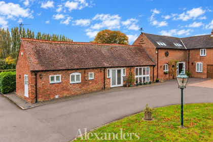
Alexanders are excited to bring to the market this delightful three bedroom detached barn conversion, brimming with rustic charm and enjoying a generous plot in a peaceful rural location. Situated between the villages of Stoke Golding and Higham on the Hill, the property is surrounded by open countryside.
A central reception hall gives access to the traditional farmhouse-style kitchen, boasting timber beams and flagstone flooring, as well as ample space for dining. A useful utility room leads to a ground-floor shower room. The generous sitting room enjoys direct access to the outdoor seating terrace via double doors and features an inset wood-burning stove with a charming red brick surround. The ground floor is completed by a further reception room, offering versatile uses as a snug, home office or playroom.
Upstairs, an impressive landing, flooded with natural light and offering space for a reading area, leads to three spacious bedrooms. One enjoys a private dressing area, whilst another benefits from bespoke fitted cabinetry. A well-appointed four-piece family bathroom serves all three bedrooms.
Approached via a gated, block-paved driveway, the property offers secure parking for multiple vehicles. A wraparound paved terrace provides a lovely spot for outdoor entertaining, with views over the manicured gardens, which are predominantly laid to lawn, and the neighbouring countryside beyond. To the front of the property is a shared courtyard area and a further driveway, providing additional parking.
Location: - The property lies between the popular villages of Stoke Golding and Higham on the Hill, with a range of local amenities available nearby. Stoke Golding is a well-established village, renowned for its strong community atmosphere and offering local shops, schooling, public houses and attractive countryside walks. The nearby Ashby Canal provides further opportunities for walking, cycling and leisure. The property is also ideally positioned for access to neighbouring market towns and major road networks, providing convenient commuting links towards Market Bosworth, Hinckley and Nuneaton.
Method Of Sale: - The property is offered for sale by Private Treaty.
Measurements: - Every care has been taken to reflect the true dimensions of this property, but they should be treated as approximate and for general guidance only.
Tenure: - The property is being sold freehold with vacant possession upon completion.
Local Authority: - Hinckley & Bosworth Borough Council, Hinckley Hub, Rugby Road, Hinckley Leics, LE10 0FR. Council Tax Band F.
Viewings: - Viewing strictly by appointment only via sole selling agent, Alexanders of Market Bosworth, 7 Main St, Market Bosworth, Nuneaton CV13 0JN.
Services: - The property is connected to mains electricity and water.
Heating is provided by an oil-fired central heating system.
Drainage is via a shared septic tank system.
Please note that none of the services, systems or appliances, including heating, plumbing and electrics, have been tested by the selling agents.
Prospective purchasers should be aware that if the private drainage system requires upgrading or replacement, it is assumed that all associated costs have been factored into any offer made. These costs will remain the responsibility of the purchaser. Interested parties are advised to carry out their own investigations, as no further information will be provided by the selling agents.
Public Rights Of Way, Wayleaves & Easements: - The property is sold subject to all existing public rights of way, wayleaves, easements and other legal rights, whether or not specifically mentioned in these particulars.
Plans And Boundaries: - The plans included in these particulars are based on Ordnance Survey data and are intended for guidance only. While believed to be correct, their accuracy is not guaranteed. The purchaser will be deemed to have full knowledge of the boundaries and the extent of the ownership. Neither the vendor nor their agents will be held responsible for defining ownership or boundary lines.
Technical Information: - Further details, including any covenants, overage provisions, or other relevant legal or technical information, can be provided upon request.
Money Laundering: - Where an offer is successfully put forward, we are obliged by law to ask the prospective purchaser for confirmation of their identity. This will include production of their passport or driving licence and recent utility bill to prove residence. Prospective purchasers will also be required to have an AML search conducted at their cost. This evidence and search will be required prior to solicitors being instructed.
General Note: - These particulars whilst believed to be accurate set out as a general outline only for guidance and do not constitute any part of an offer or contract. Intending purchasers should not rely on these particulars of sale as a statement of representation of fact, but must satisfy themselves by inspection or otherwise as to their accuracy. No person in this agents employment has the authority to make or give any representation or warranty in respect to the property.
Property Imagery Disclaimer: - Please note, digital enhancement and artificial intelligence tools may have been used on select photographs on this listing to help visualize the property's potential. These images are intended as a visual guide only and should not be relied upon as a factual representation of the current furnishings or condition. Buyers are advised to verify all details in person during an official viewing.
Map Location
Property details
- Tenure
- Freehold
- Council Tax Band
- F
- Date Posted
- 2026-10-28
Energy Performance Certificate
Energy Efficiency Rating
Based on UK Energy Performance Certificate standards (EU Directive 2002/91/EC)
Running costs are one side. Planning activity, flood history and ground risks for this location are in the full report.
Utilities & Restrictions
Utilities
- Electricity
- Mains
- Water
- Mains
- Heating
- Oil Heating
- Broadband
- Ask Agent
- Sewerage
- Septic Tank / Private
Rights & Restrictions
- Public Rights of Way
- Ask Agent
- Private Rights of Way
- Ask Agent
- Listed Property
- Ask Agent
- Restrictions
- Yes
Listed status, conservation areas and planning constraints for this location are in the full report.
Property Features
- Accessibility
- Ask Agent
- Parking
- Parking Available
- Garden
- Garden
Beyond the particulars: planning activity, flood history, heritage and ground risks, checked for this exact spot.
Connectivity
Broadband
Fastest speed available at this postcode
1.8 Gbps
Gigabit full fibre · available to 88% of premises
Suitable for
- 4K streaming on every screen
- Full-time home working
- Online gaming & big downloads
Mobile signal
Predicted 4G and 5G signal; indoor signal depends on building materials.
Ofcom Connected Nations postcode-level predictions. Speeds and signal are modelled, not measured, and vary between addresses and providers.
Signal is the easy part. Planning activity, flood history and protected designations here are in the full report.
Nearest Schools
Primary
- Higham-on-the-Hill Church of England Primary School0.8 milesNo Ofsted rating
- Ages
- 4 to 11
- Pupils
- 92
- Type
- Academy converter
- Faith
- Church of England
- St Margaret's Church of England Primary School, Stoke Golding1.1 milesOfsted: Good *
- Ages
- 5 to 11
- Pupils
- 217
- Type
- Academy converter
- Faith
- Church of England
- Milby Primary School1.8 milesNo Ofsted rating
- Ages
- 4 to 11
- Pupils
- 422
- Type
- Community school
- Hollycroft Primary School2 milesOfsted report card · Jun 2026
- Ages
- 4 to 11
- Pupils
- 71
- Type
- Free schools
- Lower Farm Academy2 milesOfsted: Good
- Ages
- 2 to 11
- Pupils
- 410
- Type
- Free schools
Secondary
- Saint Martin's Catholic Voluntary Academy1.6 milesNo Ofsted rating
- Ages
- 11 to 16
- Pupils
- 731
- Type
- Academy converter
- Faith
- Roman Catholic
- Higham Lane North Academy1.7 milesNo Ofsted rating
- Ages
- 11 to 16
- Pupils
- 154
- Type
- Free schools
- Redmoor Academy2.4 milesOfsted report card · Apr 2026
- Ages
- 11 to 16
- Pupils
- 990
- Type
- Academy converter
- Higham Lane School2.5 milesNo Ofsted rating
- Ages
- 11 to 18
- Pupils
- 1,516
- Type
- Academy converter
- Etone College3 milesNo Ofsted rating
- Ages
- 11 to 18
- Pupils
- 1,164
- Type
- Academy converter
* Latest graded judgement covers quality of education only; no overall grade was issued under the 2024-25 inspection framework.
Distances are straight-line from the advertised location. Source: the national school registers (DfE, Welsh Government, Scottish Government) and Ofsted.
Schools are just the start: sold prices nearby, planning activity and any flood history are in the full report.
Amenities
Supermarket
GP surgery
Pharmacy
Hospital
Straight-line distances from the advertised location. Sources: NHS records, Geolytix supermarket locations, OS Open Greenspace and the national trails registers.
The area stacks up? Now check the location itself: planning nearby, protected designations and past flooding.
Getting Around
Nearest station
Nearest bus stop
Typical drive times
Straight-line distances from the advertised location; drive times are typical free-flow times over OpenStreetMap road data, so allow more at peak. Public transport locations from DfT NaPTAN.
Easy to reach matters. So do planning activity, flood history and ground risks: all in the full report.
Flood Risk
Environment Agency open data, checked around the advertised map pin for the listed acreage. Long-term risk counts flood defences; the planning map's flood zones do not. The map pin for this listing marks the postcode area rather than the exact location, so these readings describe the surrounding area. Provided by LandSale, not the listing agent, and not part of the agent's particulars. Risk varies across a holding, so verify before committing.
Rivers and the sea
Planning map: Flood Zone 1.
Surface water
Not at the pin: mapped about 10 metres away.
These bandings are the summary. Where this location sits on the flood maps, plus planning activity, heritage and ground risks, is in the full report.
Important notice: Information, maps and tags on this page are drawn from the advertising agent's marketing materials or generated automatically. LandSale has not verified them. Relying on these details is at your own risk, always carry out independent checks before committing to a purchase.
LandSale full disclaimer
Marketing information only - not formal particulars. The details on this website are provided for general guidance and do not constitute an offer or contract. Neither LandSale nor the advertising estate/land agent accepts responsibility for any inaccuracy.
1. Source of information
- Listing content: Core description, asking price, tenure, measurements, photographs and planning history originate from the marketing materials of the advertising estate or land agent. LandSale does not author this content and cannot guarantee its accuracy.
- Automated tags & categorisation: Property type, land-use class, acreage bands and similar labels may be applied by machine-learning models. They are intended as a helpful guide only and may not reflect the property's legal status or permitted use.
- Third-party & enriched data layers: Maps, boundary outlines, planning designations, soil reports, broadband coverage and other environmental or location-based insights are licensed from external suppliers. Such data are supplied “as is", may be incomplete or out of date and are subject to change without notice.
2. Verification required
Prospective purchasers must verify critical matters, including but not limited to planning permission, title boundaries, public rights of way, environmental constraints, acreage, services, access and VAT status, through their own inspections, specialist surveys, legal advisers and the selling agent before relying on the information or entering into any contract.
3. No warranty or liability
LandSale gives no warranty, express or implied, as to the accuracy, completeness or fitness for any particular purpose of the information displayed. LandSale shall not be liable for any loss, damage, cost or expense arising directly or indirectly from any use of or reliance on such information, save where liability may not be excluded by law.
4. Updates & feedback
If you believe any detail on this listing is inaccurate, please let us know. We will investigate and, where appropriate, update the listing or notify the agent.
© LandSale | Version 1.3 - August 2026
Contact Alexanders, Market Bosworth
7 Main Street, Market Bosworth, Leicestershire, CV13 0JN
View agent profileSimilar properties for sale
- Price
- Guide Price£395,000
Main Street, Stoke Golding, Stoke Golding, Leicestershire CV13 England
Added on 28/10/2026Barn Conversion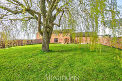
- Price
- Guide Price£499,950
Market Bosworth Road, Dadlington, Dadlington & Sutton Cheney, Leicestershire CV13 England
Added on 27/02/2026Barn Conversion Added on 06/10/2026Building Plot
 Added on 29/01/2026Development Land
- Price
- Offers Over£400,000
Coleshill Road, Ansley Common, Ansley, Warwickshire CV10 England
Added on 21/09/2026Barn Conversion Added on 19/10/2026Barn Conversion
- Price
- Guide Price£385,000
Pipe Lane, Orton-On-The-Hill, Twycross, Leicestershire CV9 England
Added on 20/08/2026Barn Conversion Added on 05/09/2026Barn Conversion
- Price
- Guide Price£450,000
- Size
- 3 acres
Building Plot, The Barns, Nailstone, Nailstone, Leicestershire CV13 England
Added on 02/10/2026Self Build Plot
- Price
- Guide Price£600,000
- Size
- 0.4 acres
Added on 30/07/2026Development Land