193 Acres Of Land At Hall Farm, Clawson Road, Long Clawson, Melton Mowbray, Leicestershire, LE14
- Land size
- 196.36 acres
Key Features
- 196.36 Acres of Predominantly Arable Land
- Available as a whole or in two lots
- Excellent access to A46 and A606
- What3wordsLot 1 - ///anguished.indicate.poppingLot 2 - ///insect.summer.s
Description
Detailed Description
Agricultural Land
The land is classified as Grade 3 under the Agricultural Land Classification system.
The soils belong to the Denchworth series according to soil series of England and Wales which are described as slowly permeable, seasonally waterlogged clayey soils with similar fine loamy over clayey soils. There are also areas of soil belonging to the Ragdale series, described as slowly permeable, seasonally waterlogged clayey and fine loamy over clayey soils.
Environmental schemes
The land is entered into a Sustainable Farming Incentive Agreement, which expires on 31st March 2027 and 31st March 2028 respectively. The relevant options are set out below:
Option Code Option Description Action End Date
AHL2 Winter bird food on arable and horticultural land 31/03/2027
AHW2 Supplementary winter bird food 31/03/2028
HRW1 Assess and record hedgerow condition 31/03/2027
HRW2 Manage hedgerows 31/03/2027
IPM4 No use of insecticide, nematicide or acaricide on
arable crops and permanent crops 31/03/2027
SAM1 Assess soil, produce a soil management plan
and test soil organic matter 31/03/2027
The successful Purchaser will indemnify the Vendor against any breaches or penalties in that regard.
Field schedule:
Field No. Hectares Acres Use
6291 10.45 25.81 Arable
5362 8.60 21.25 Arable
7749 6.93 17.12 Arable
6024 8.59 21.22 Arable
9019 10.45 25.81 Arable
7496 7.32 18.08 Arable
4004 2.87 7.1 Arable
2301 1.47 3.62 Arable
2692 0.33 0.81 Miscellaneous
2787 0.26 0.64 Miscellaneous
5084 9.70 23.98 Arable
7863 5.95 14.71 Arable
8031 6.56 16.21 Arable
TOTAL 79.48 196.36
Tenure and Possession
The property being sold has Freehold Title and will be sold subject to a Farm Business Tenancy expiring in October 2027.
Sporting Rights
The Purchaser will agree to let the current Shooting Syndicate benefit from the sporting Rights until the end of the current season, being 1st February 2027, and not to remove any game or wild bird seed plots until after that date.[CM1.1]
Plans, Areas and schedules
These have been prepared as carefully as possible and are based on the Ordinance survey 1:2500 scale plans. The plans are published for illustrative purposes only and although they are believed to be correct, their accuracy is not guaranteed.
Wayleaves, Easements and Rights of Way
The property is sold subject to and with the help and benefit of all existing rights of way, whether public or private, light support, drainage, water and electricity supplies and other rights, easements, quasi-easements, and all wayleaves referred to or not in these particulars.
The property is subject to the following Public Footpaths:
LT|Leicestershire|F43/1 from Long Clawson towards Hose.
LT|Leicestershire|G45/1from Long Clawson towards Scalford.
LT|Leicestershire|G44/1from Long Clawson towards Scalford.
There are high voltage overhead electricity cables crossing the land, with National Grid being the Network Operator.
Boundaries
The Purchaser shall be deemed to have full knowledge of all boundaries and neither the Vendor nor the vendor's Agent will be responsible for defining boundaries nor their ownership.
Land Registry Title Numbers
The property is registered with the Land Registry and forms part of the Land Registry Title Number LT399092.
Sporting, Timber & Mineral Rights
The sporting rights[CM2.1], mineral rights and timber rights will be included within the freehold so far as they are owned by the Vendor.
Disputes
Should any disputes arise as to the boundaries or any point arising in the General Remarks and stipulations or Particulars of Sale, Schedules, Plans or interpretations of any of them, the matter shall be referred to an Arbitrator to be appointment by the Vendor's Agent.
The Purchaser shall be deemed to have full knowledge of all boundaries and neither the Vendor nor the Vendor's Agent will be responsible for defining boundaries or the ownership thereof.
Fixtures and Fittings
All fixtures and fittings are excluded from the sale unless specifically referred to in these particulars.
Local Authority
Melton Borough Council, Parkside, Station Approach, Burton Street, Melton Mowbray, Leicestershire, LE13 1GH
T:
Anti-Money Laundering Regulations
In accordance with the most recent Anti-Money Laundering Legislation, the Purchaser will be required to provide proof of identity and address to the Vendor's Agent once an offer has been submitted and accepted (subject to contract) prior to Solicitors being instructed.
Solicitor Details
Chattertons
9 Broad St, Stamford PE9 1PY
Jonathan Blythe
T:
M:
E: jonathan.
Selling Agent
Brown & Co
5 Geoff Monk Way, Birstall, Leicestershire, LE4 3BU
Gilbert G Watchorn Bsc (Hons) MRICS FAAV
T:
M:
E: gilbert.
Charlotte Mountford BA (Hons)
T:
M:
E: charlotte.
Location
The land lies on the east side of Waltham Road in Long Clawson, Nottinghamshire. Situated within the Vale of Belvoir, the village offers a range of local amenities. The land enjoys both a convenient and tranquil rural location with excellent access to the A46 and A606, placing the commercial centres of Nottingham, Melton Mowbray and Leicester within easy reach. The surrounding area is characterised by undulating mixed farmland and attractive open countryside, making the property well positioned for both farming, amenity and investment purposes.
The land is located approximately 13 miles south-east of Nottingham and 5 miles north of Melton Mowbray.
What3words
Lot 1 - ///anguished.indicate.popping
Lot 2 - ///insect.summer.sunblock
Map Location
Property details
- Tenure
- Freehold
- Council Tax Band
- Ask Agent
- Date Posted
- 2026-10-20
Market Value Analysis
Compared with 17 Farmland & Pasture listings in East Midlands (100+ acres).
Utilities & Restrictions
Utilities
- Electricity
- Ask Agent
- Water
- Ask Agent
- Heating
- Ask Agent
- Broadband
- Ask Agent
- Sewerage
- Ask Agent
Rights & Restrictions
- Public Rights of Way
- Ask Agent
- Private Rights of Way
- Ask Agent
- Listed Property
- Ask Agent
- Restrictions
- Ask Agent
Listed status, conservation areas and planning constraints for this location are in the full report.
Property Features
- Accessibility
- Ask Agent
- Parking
- Ask Agent
- Garden
- Ask Agent
Beyond the particulars: planning activity, flood history, heritage and ground risks, checked for this exact spot.
Connectivity
Broadband
Fastest speed available at this postcode
1.8 Gbps
Gigabit full fibre
Suitable for
- 4K streaming on every screen
- Full-time home working
- Online gaming & big downloads
Mobile signal
Predicted 4G and 5G signal; indoor signal depends on building materials.
Ofcom Connected Nations postcode-level predictions. Speeds and signal are modelled, not measured, and vary between addresses and providers.
Signal is the easy part. Planning activity, flood history and protected designations here are in the full report.
Nearest Schools
Primary
- Long Clawson Church of England Primary School1.3 milesOfsted: Good *
- Ages
- 4 to 11
- Pupils
- 57
- Type
- Voluntary controlled school
- Faith
- Church of England
- Scalford Church of England Primary School1.9 milesNo Ofsted rating
- Ages
- 4 to 11
- Pupils
- 69
- Type
- Academy converter
- Faith
- Church of England
- Ab Kettleby Primary School2.1 milesOfsted: Good
- Ages
- 4 to 11
- Pupils
- 67
- Type
- Academy converter
- Hose Church of England Primary School2.1 milesOfsted: Good *
- Ages
- 4 to 11
- Pupils
- 43
- Type
- Voluntary controlled school
- Faith
- Church of England
- St Mary's Church of England Primary School3.2 milesOfsted: Good *
- Ages
- 4 to 11
- Pupils
- 179
- Type
- Academy sponsor led
- Faith
- Church of England
Secondary
- John Ferneley College3.1 milesOfsted: Requires improvement
- Ages
- 11 to 16
- Pupils
- 1,170
- Type
- Academy converter
- Long Field Spencer Academy4.5 milesNo Ofsted rating
- Ages
- 11 to 19
- Pupils
- 930
- Type
- Academy converter
- The South Wolds Academy & Sixth Form8.3 milesOfsted: Good *
- Ages
- 11 to 18
- Pupils
- 1,033
- Type
- Academy converter
- The Priory Belvoir Academy8.7 milesNo Ofsted rating
- Ages
- 11 to 16
- Pupils
- 672
- Type
- Academy converter
- Toot Hill School8.8 milesOfsted: Good
- Ages
- 11 to 18
- Pupils
- 1,838
- Type
- Academy converter
* Latest graded judgement covers quality of education only; no overall grade was issued under the 2024-25 inspection framework.
Distances are straight-line from the advertised location. Source: the national school registers (DfE, Welsh Government, Scottish Government) and Ofsted.
Schools are just the start: sold prices nearby, planning activity and any flood history are in the full report.
Amenities
Supermarket
GP surgery
Pharmacy
Hospital
Straight-line distances from the advertised location. Sources: NHS records, Geolytix supermarket locations, OS Open Greenspace and the national trails registers.
The area stacks up? Now check the location itself: planning nearby, protected designations and past flooding.
Getting Around
Nearest station
Nearest bus stop
Typical drive times
Straight-line distances from the advertised location; drive times are typical free-flow times over OpenStreetMap road data, so allow more at peak. Public transport locations from DfT NaPTAN.
Easy to reach matters. So do planning activity, flood history and ground risks: all in the full report.
Flood Risk
Environment Agency open data, checked around the advertised map pin for the listed acreage. Long-term risk counts flood defences; the planning map's flood zones do not. Provided by LandSale, not the listing agent, and not part of the agent's particulars. Risk varies across a holding, so verify before committing.
Rivers and the sea
Planning map: Flood Zone 1.
Surface water
Not at the pin: mapped about 40 metres away.
These bandings are the summary. Where this location sits on the flood maps, plus planning activity, heritage and ground risks, is in the full report.
Important notice: Information, maps and tags on this page are drawn from the advertising agent's marketing materials or generated automatically. LandSale has not verified them. Relying on these details is at your own risk, always carry out independent checks before committing to a purchase.
LandSale full disclaimer
Marketing information only - not formal particulars. The details on this website are provided for general guidance and do not constitute an offer or contract. Neither LandSale nor the advertising estate/land agent accepts responsibility for any inaccuracy.
1. Source of information
- Listing content: Core description, asking price, tenure, measurements, photographs and planning history originate from the marketing materials of the advertising estate or land agent. LandSale does not author this content and cannot guarantee its accuracy.
- Automated tags & categorisation: Property type, land-use class, acreage bands and similar labels may be applied by machine-learning models. They are intended as a helpful guide only and may not reflect the property's legal status or permitted use.
- Third-party & enriched data layers: Maps, boundary outlines, planning designations, soil reports, broadband coverage and other environmental or location-based insights are licensed from external suppliers. Such data are supplied “as is", may be incomplete or out of date and are subject to change without notice.
2. Verification required
Prospective purchasers must verify critical matters, including but not limited to planning permission, title boundaries, public rights of way, environmental constraints, acreage, services, access and VAT status, through their own inspections, specialist surveys, legal advisers and the selling agent before relying on the information or entering into any contract.
3. No warranty or liability
LandSale gives no warranty, express or implied, as to the accuracy, completeness or fitness for any particular purpose of the information displayed. LandSale shall not be liable for any loss, damage, cost or expense arising directly or indirectly from any use of or reliance on such information, save where liability may not be excluded by law.
4. Updates & feedback
If you believe any detail on this listing is inaccurate, please let us know. We will investigate and, where appropriate, update the listing or notify the agent.
© LandSale | Version 1.3 - August 2026
Contact BROWN & CO-PROPERTY AND BUSINESS CONSULTANTS LLP, Leicester
View agent profileSimilar properties for sale
- Price
- Guide Price£1,350,000
- Size
- 143.46 acres
Added on 04/09/2026Farmland
- Price
- Guide Price£1,200,000
- Size
- 156.74 acres
Added on 27/06/2026Farm
- Price
- Guide Price£1,200,000
- Size
- 70.69 acres
Added on 24/09/2026Agricultural Land
- Price
- Guide Price£1,725,000
- Size
- 206.58 acres
Whisby, Lincoln, Doddington and Whisby, Lincolnshire LN6 England
Added on 07/10/2026Arable Land
- Price
- Guide Price£1,915,000
- Size
- 210.07 acres
Added on 31/05/2026Farmland
- Price
- Guide Price£1,175,000
- Size
- 130.17 acres
Lot 2 - Land and Buildings at Mount Pleasant Farm, Winwick, Winwick, Cambridgeshire PE28 England
Added on 24/09/2026Farmland
- Price
- Guide Price£2,155,000
- Size
- 212.16 acres
Land and Buildings at Mount Pleasant Farm, Winwick, Winwick, Cambridgeshire PE28 England
Added on 24/09/2026Farmland
- Price
- Guide Price£1,500,000
- Size
- 135.76 acres
Added on 29/01/2026Farmland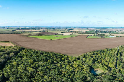
- Price
- Guide Price£1,895,000
- Size
- 209.24 acres
Land North Of Ramsey Road, Warboys, PE28, Warboys, Cambridgeshire PE28 England
Added on 12/10/2026Farmland
- Price
- Guide Price£1,900,000
- Size
- 119.57 acres
Grade 1 Arable Silt Land, For Sale and To Let, Leverton, Lincolnshire PE22 England
Added on 18/08/2026Arable Land