Princes Gate, Narberth, SA67
- Land size
- 12 acres
- Bedrooms
- 4
- Bathrooms
- 1
Key Features
- Great Renovation Project
- Superb Location with Countryside Views
- Location - Narberth
- EPC Rating - D ** Potential - B
- Detached Double Garage
- 12 Acres Productive Land
- Generous Gardens & Grounds
- Various outbuildings including two substantial modern outbuildings
Description
12 Acres and Great Location with huge potential to refurbish a period farmhouse a prominent location with views of open countryside and over its own land with the Preseli Mountains in the distance. The original farmhouse still stands with potential for residential/ holiday use ( STP). IMpresive range of modern outbuildings include a Handy double garage with 2 x roller door access. Three further multi purpose storage sheds. The main residence has a commanding position with views to fore. Currently offering 4 bedroom accommodation but is versatile and flexible rooms could be split or able to take more bedrooms if required. The property could offer a retreat or similar, great family home, or with the great set of outbuildings run a business from subject to planning consents. Set in its own land and in one block adjoining
Directions : From Carmarthen take A 40 west towards St. Clears. At the roundabout take the first junction off towards Tenby on the A 477. After a little over a mile turn left for Llanddowror. Travel on this windy road going through the village and onto Red Roses. In the village of Red Roses turn right by the Sporting Chance public house and carry on. Go through Taverspite village and carry on the B4314, go passed turning for Tavernspite and Narberth. Carry on for just over a mile and the large wide entrance will be found on the left hand side before a small bridge and The Grange Farm yard.
What3words Location ///tooth.activism.collides
Farmhouse
A substantial period farmhouse is offered having a commanding position and location with views to fore as far as the Preseli Mountains. Some work has been carried out to the property but is in need of further renovation. Some internal insulation work has been done and the property has a ground source heat pump heating system.
Location
The property offers a commanding location with some superb rural views to fore. A shared access drive leads to its own tree lined drive which terminates at the farmhouse. The property is close to Princess Gate and Tavernspite villages. With Ludchurch village nearby the property is situated in a central and convenient location on the Pembrokeshire/ Carmarthenshire borders. Narberth is 4 miles with train station, Whitland 5 miles, Tenby ( coastline)11 miles approx. The main A 40 carriageway is conveniently located for access back to the M4 or continue onto the termination in Fishguard with the Ferry crossing to Ireland.
Freezer / Boot Room
3.75m x 2.46m (12' 4" x 8' 1")
Kitchen
5.3m x 3.34m (17' 5" x 10' 11")
Sitting Room
4.43m x 4.03m (14' 6" x 13' 3")
Living Room
5.24m x 4.09m (17' 2" x 13' 5")
Utility
3.3m x 3.3m (10' 10" x 10' 10")
Boiler Room
3.34m x 1.93m (10' 11" x 6' 4")
Landing
Cloakroom
WC and wash hand basin.
Bedroom 1
3.1m x 3.04m (10' 2" x 10' 0")
Bedroom 2
3.4m x 3.45m (11' 2" x 11' 4")
Bathroom
2.1m x 1.8m (6' 11" x 5' 11")
Bedroom & Dressing Room 1
2.36m x 4.02m (7' 9" x 13' 2") & 4.3m x 2.8m (14' 1" x 9' 2")
Bedroom & Dressing Room 2
1.81m x 3.3m (5' 11" x 10' 10") & 2.97m x 3.35m (9' 9" x 11' 0")
Externally
Access from the roadway leading along a track with turning off for a tree lined private access track sweeping up to the house. The lane splits with one leading to the main outbuildings which are listed below. Second track leading to Parking and turning area with access off to the old farmhouse and double garage. The access road has a stream and natural pond along the side with mature broadleaf trees lining the lane. 12 acres of land which is a rich red sandstone land capable of good growing quantities. Split into 2 main fields, woodland and yard areas.
Land
Two fields to the front of the property being level to gently sloping. Recently re seeded and in good heart. There are some wooded areas giving it some lovely sheltered areas. Open yards give good parking and turning areas.
Outbuildings
Garage / Storage 12meters X 6.3 Meters. 2 x Roller shutter doors with concrete floors.
Old Original Farmhouse 4.8 X 10 Meters.
Former Dairy 3.2 m X 4.5 meters.
Store Shed 18m X 8.5 meters. Lean too 18m X 3.2m.
Store Shed 28m X 6.3 meters with 3.8 meters to lower eaves with large access doors and concrete floors.
Modern 30 meter X 15 Meter outbuilding. 2 X Roller shutter doors 5 meter high.
Services
We have been informed by the current vendor that the property benefits from mains water, mains electric, private drainage and ground source heat pump heating.
Tenure and Possession
We are informed the property is of Freehold Tenure and will be vacant on completion
Anti Money Laundering
To comply with Government anti-money laundering legislation, we are legally required to carry out identity and verification checks on all buyers and sellers. We work with our trusted and industry-recognised partner, Coadjute, who will send you a secure link to complete these biometric checks electronically once your offer has been accepted (subject to contract). A non-refundable fee of £45 + VAT per person is payable directly to Coadjute for this service. These checks must be completed before we can issue the memorandum of sale to the solicitors and progress the transaction.
If you have any questions or need any assistance, please don’t hesitate to contact the office – we’re always happy to help.
Land Transaction Tax
The purchase of this property may be subject to Land Transaction Tax (LTT). The amount payable will depend upon the purchase price and the purchaser’s individual circumstances. Buyers are advised to use the Welsh Revenue Authority Land Transaction Tax calculator and/or seek advice from their solicitor or financial adviser.
Map Location
Property details
- Tenure
- Freehold
- Council Tax Band
- Ask Agent
- Date Posted
- 2026-10-17
Market Value Analysis
Compared with 221 Farms & Smallholdings listings in Wales (10+ acres).
Energy Performance Certificate
Energy Efficiency Rating
Based on UK Energy Performance Certificate standards (EU Directive 2002/91/EC)
Running costs are one side. Planning activity, flood history and ground risks for this location are in the full report.
Utilities & Restrictions
Utilities
- Electricity
- Mains
- Water
- Mains
- Heating
- Ground Source Heat Pump
- Broadband
- Fibre (FTTC)
- Sewerage
- Septic Tank / Private
Rights & Restrictions
- Public Rights of Way
- Ask Agent
- Private Rights of Way
- Ask Agent
- Listed Property
- Ask Agent
- Restrictions
- Ask Agent
Listed status, conservation areas and planning constraints for this location are in the full report.
Property Features
- Accessibility
- Ask Agent
- Parking
- Driveway
- Garden
- Garden
Beyond the particulars: planning activity, flood history, heritage and ground risks, checked for this exact spot.
Connectivity
Broadband
Fastest speed available at this postcode
18 Mbps
Standard (10-30 Mbps)
Suitable for
- Web & social
- Music streaming
- Standard video calls
Mobile signal
Predicted 4G and 5G signal; indoor signal depends on building materials.
Ofcom Connected Nations postcode-level predictions. Speeds and signal are modelled, not measured, and vary between addresses and providers.
Signal is the easy part. Planning activity, flood history and protected designations here are in the full report.
Nearest Schools
Primary
- Tavernspite Community Primary School2 miles
- Pupils
- 208
- Type
- Nursery, Infants & Juniors
- Language
- English medium school / provision
- Templeton Community Primary School2.1 miles
- Pupils
- 126
- Type
- Nursery, Infants & Juniors
- Language
- English medium school / provision
- Narberth Community Primary School2.7 miles
- Pupils
- 281
- Type
- Nursery, Infants & Juniors
- Language
- Dual language school / provision (Welsh and English) (including transitional)
- Stepaside Community Primary School3.2 miles
- Pupils
- 119
- Type
- Nursery, Infants & Juniors
- Language
- English medium school / provision
- Saundersfoot Community Primary School4.4 miles
- Pupils
- 172
- Type
- Nursery, Infants & Juniors
- Language
- English medium school / provision
Secondary
- Dyffryn Taf4.3 miles
- Pupils
- 890
- Type
- Secondary (ages 11-19)
- Language
- Dual language school / provision (Welsh and English) (including transitional)
- Ysgol Greenhill School7.2 miles
- Pupils
- 877
- Type
- Secondary (ages 11-19)
- Language
- English medium school / provision
- Ysgol Harri Tudur / Henry Tudor School12 miles
- Pupils
- 1,152
- Type
- Secondary (ages 11-19)
- Language
- English medium school / provision
- Ysgol Caer Elen12 miles
- Pupils
- 907
- Type
- Middle (ages 3-16)
- Language
- Welsh medium school / provision (including transitional)
- Haverfordwest High VC School13 miles
- Pupils
- 1,699
- Type
- Secondary (ages 11-19)
- Language
- English medium school / provision
Distances are straight-line from the advertised location. Source: the national school registers (DfE, Welsh Government, Scottish Government) and Ofsted.
Schools are just the start: sold prices nearby, planning activity and any flood history are in the full report.
Amenities
Supermarket
GP surgery
Pharmacy
Straight-line distances from the advertised location. Sources: NHS records, Geolytix supermarket locations, OS Open Greenspace and the national trails registers.
The area stacks up? Now check the location itself: planning nearby, protected designations and past flooding.
Getting Around
Nearest station
Nearest bus stop
Typical drive times
Straight-line distances from the advertised location; drive times are typical free-flow times over OpenStreetMap road data, so allow more at peak. Public transport locations from DfT NaPTAN.
Easy to reach matters. So do planning activity, flood history and ground risks: all in the full report.
Flood Risk
Natural Resources Wales open data, checked around the advertised map pin for the listed acreage. Long-term risk counts flood defences; the planning map's flood zones do not. Provided by LandSale, not the listing agent, and not part of the agent's particulars. Risk varies across a holding, so verify before committing.
Rivers and the sea
Planning map: Flood Zone 1.
Surface water
Not at the pin: mapped about 110 metres away.
These bandings are the summary. Where this location sits on the flood maps, plus planning activity, heritage and ground risks, is in the full report.
Important notice: Information, maps and tags on this page are drawn from the advertising agent's marketing materials or generated automatically. LandSale has not verified them. Relying on these details is at your own risk, always carry out independent checks before committing to a purchase.
LandSale full disclaimer
Marketing information only - not formal particulars. The details on this website are provided for general guidance and do not constitute an offer or contract. Neither LandSale nor the advertising estate/land agent accepts responsibility for any inaccuracy.
1. Source of information
- Listing content: Core description, asking price, tenure, measurements, photographs and planning history originate from the marketing materials of the advertising estate or land agent. LandSale does not author this content and cannot guarantee its accuracy.
- Automated tags & categorisation: Property type, land-use class, acreage bands and similar labels may be applied by machine-learning models. They are intended as a helpful guide only and may not reflect the property's legal status or permitted use.
- Third-party & enriched data layers: Maps, boundary outlines, planning designations, soil reports, broadband coverage and other environmental or location-based insights are licensed from external suppliers. Such data are supplied “as is", may be incomplete or out of date and are subject to change without notice.
2. Verification required
Prospective purchasers must verify critical matters, including but not limited to planning permission, title boundaries, public rights of way, environmental constraints, acreage, services, access and VAT status, through their own inspections, specialist surveys, legal advisers and the selling agent before relying on the information or entering into any contract.
3. No warranty or liability
LandSale gives no warranty, express or implied, as to the accuracy, completeness or fitness for any particular purpose of the information displayed. LandSale shall not be liable for any loss, damage, cost or expense arising directly or indirectly from any use of or reliance on such information, save where liability may not be excluded by law.
4. Updates & feedback
If you believe any detail on this listing is inaccurate, please let us know. We will investigate and, where appropriate, update the listing or notify the agent.
© LandSale | Version 1.3 - August 2026
Listing agent
Morgan & Davies, Carmarthen
11 Lammas Street, Carmarthen, SA31 3AD
Similar properties for sale
- Price
- Offers in Region of£599,950
- Size
- 9 acres
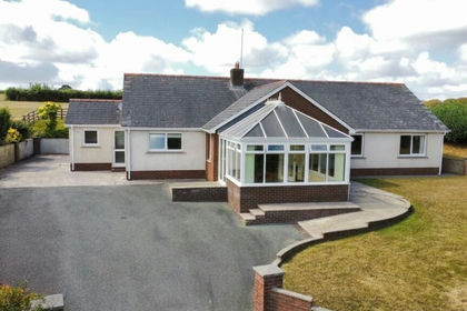
Princes Gate, Narberth, SA67, Lampeter Velfrey, Pembrokeshire SA67 Wales
Added on 26/08/2026Smallholding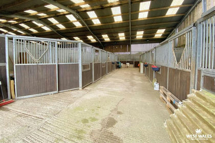
- Price
- £700,000
- Size
- 25 acres
Tavernspite, Whitland, Eglwyscummin, Carmarthenshire SA34 Wales
Added on 29/01/2026Smallholding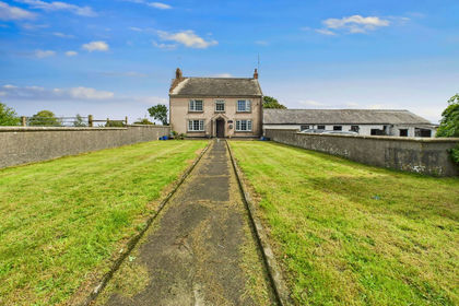
- Price
- Guide Price£635,000
- Size
- 12 acres
Reynalton, Kilgetty, SA68, Kilgetty, Pembrokeshire SA68 Wales
Added on 18/06/2026Farmhouse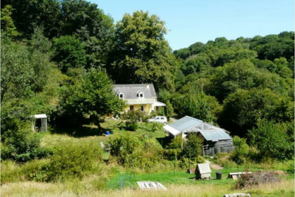
- Price
- Offers in Region of£530,000
- Size
- 6 acres
Hafod Y Dail, Clynderwen, SA66, New Moat, Pembrokeshire SA66 Wales
Added on 26/09/2026Smallholding
- Price
- Offers in Region of£699,950
- Size
- 17 acres
Laugharne, Carmarthen, SA33, Laugharne Township, Carmarthenshire SA33 Wales
Added on 02/05/2026Smallholding
- Price
- Guide Price£485,000
- Size
- 21.54 acres
Llandawke, Laugharne, Carmarthen, SA33, Carmarthen, Carmarthenshire SA33 Wales
Added on 26/08/2026Smallholding
- Price
- Offers in Region of£720,000
- Size
- 15 acres
Landshipping, Narberth, SA67, Martletwy, Pembrokeshire SA67 Wales
Added on 29/01/2026Smallholding
- Price
- Offers in Region of£725,000
- Size
- 15.67 acres
Penbontbren, Login, Whitland, SA34, Whitland, Carmarthenshire SA34 Wales
Added on 18/04/2026Smallholding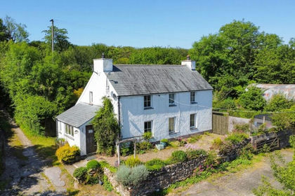
- Price
- Offers in Region of£695,000
- Size
- 28 acres
Llanycefn, Clynderwen, SA66, Maenclochog, Pembrokeshire SA66 Wales
Added on 05/06/2026Smallholding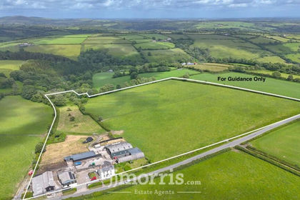
- Price
- £650,000
- Size
- 16 acres
Maenclochog, Clynderwen, SA66, Maenclochog, Pembrokeshire SA66 Wales
Added on 04/07/2026Smallholding